22188+4604 TDT 3457 (HD 212029)
22h 18m 46.21s +46° 04' 17.1" P.A. 246.00 sep 0.5 mag 10.86,10.92 dist. 58.55 pc (190.99 l.y.)
| Coord 2000 |
22188+4604 |
|
Discov num |
TDT3457 |
|
Comp |
|
|
Coord arcsec 2000 |
22 18 46.21 +46 04 17.1 |
|
| Date first |
1991 |
|
Date last |
1991 |
|
Obs |
1 |
|
| Pa first |
246 |
|
Pa last |
246.4 |
|
P.A. Now (θ) |
246.4° |
|
| Sep first |
0.5 |
|
Sep last |
0.47 |
|
Sep. Now (ρ) |
0.47" |
|
| Mag pri |
10.86 |
|
Mag sec |
10.92 |
|
delta mag (ΔM) |
0.06 |
|
Spectral class |
|
|
| Pri motion ra |
+000 |
|
Sec motion ra |
+000 |
|
| Pri motion dec |
+004 |
|
Sec motion dec |
+004 |
|
| Notes |
|
|
Nature of this double is uncertain.
OTHER CATALOGS AND DESIGNATIONS
| Name |
HD 212029 |
|
Spectr |
G0 |
|
Constellation |
Lacerta |
|
HIP |
110291 |
|
| Tycho2 |
3607-02544-1 |
|
Gaia DR2 |
1962427324133658752 |
|
HD |
212029 |
|
BD |
BD+45 3890 |
|
| Distance |
58.55 |
|
Distance ly |
190.99 |
|
ORBITAL ELEMENTS SOLUTION #1
| Period (P) | 757d (2.07y) | ± 70 |
Periastron (T) | 48769d (1992.401y) | ± 316 |
Semi-major axis (a) | 17m | ± 17 |
| Eccentricity (e) | 0.92 | ± 0.2 |
Inclination (i) | 99° | ± 10 |
Longitude of periastron (ω) | 85° | ± 55 |
| Node (Ω) | 72° | ± 99 |
Notes | | |
Reference | Gln2006 | |
| Equinox | | |
Last observation | 1993 | |
Grade | 9 | (1=Definitive, 9=Indet.) |
| label |
theta |
rho |
| 2000-01-01 |
151.3 |
0.005 |
| 2001-01-01 |
231.7 |
0.009 |
| 2002-01-01 |
160.8 |
0.005 |
| 2003-01-01 |
234.7 |
0.008 |
| 2004-01-01 |
170.0 |
0.005 |
| 2005-01-01 |
238.0 |
0.008 |
| 2006-01-01 |
178.4 |
0.005 |
| 2007-01-01 |
242.2 |
0.007 |
| 2008-01-01 |
186.0 |
0.006 |
| 2009-01-01 |
251.2 |
0.003 |
| 2010-01-01 |
192.8 |
0.006 |
| 2011-01-01 |
81.6 |
0.005 |
| 2012-01-01 |
198.8 |
0.006 |
| 2013-01-01 |
89.6 |
0.006 |
| 2014-01-01 |
204.1 |
0.007 |
| 2015-01-01 |
96.3 |
0.006 |
| 2016-01-01 |
208.8 |
0.007 |
| 2017-01-01 |
102.8 |
0.006 |
| 2018-01-01 |
213.0 |
0.008 |
| 2019-01-01 |
109.8 |
0.006 |
| 2020-01-01 |
216.8 |
0.008 |
| 2021-01-01 |
117.3 |
0.005 |
| 2022-01-01 |
220.2 |
0.008 |
| 2023-01-01 |
125.6 |
0.005 |
| 2024-01-01 |
223.4 |
0.008 |
| 2025-01-01 |
134.4 |
0.005 |
| 2026-01-01 |
226.5 |
0.009 |
| 2027-01-01 |
143.8 |
0.005 |
| 2028-01-01 |
229.4 |
0.009 |
| 2029-01-01 |
153.4 |
0.005 |
| 2030-01-01 |
232.4 |
0.009 |
|
|
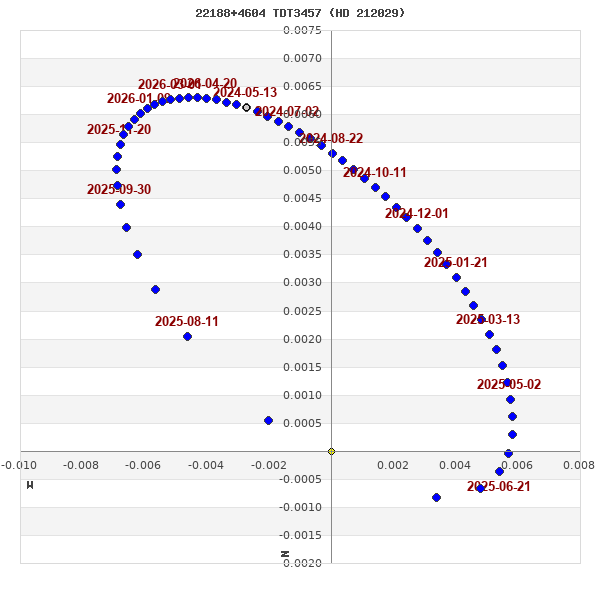
Note: Theta is PA, Rho is Sep. For yearly orbits, data refer to Jan 1st.
|
|
|
|
|
|
|
|
Measures: green=micrometric, blue=interferometric, purple=photographic |
|
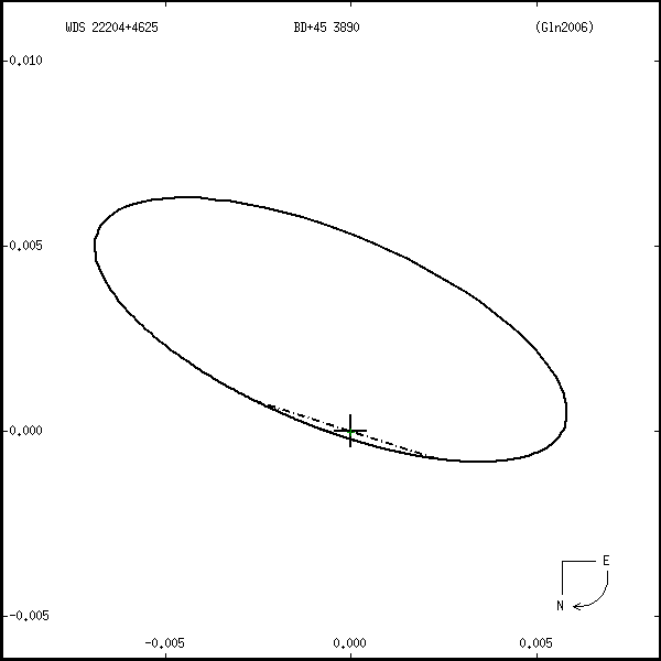
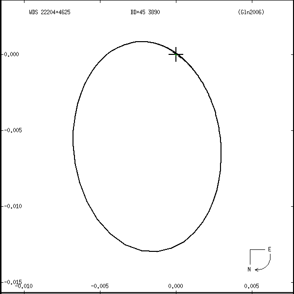
ORBITAL ELEMENTS SOLUTION #2
| Period (P) | 794d (2.17y) | ± 52 |
Periastron (T) | 48911d (1992.79y) | ± 322 |
Semi-major axis (a) | 39m | ± 22 |
| Eccentricity (e) | 0.99 | ± 0.09 |
Inclination (i) | 99° | ± 9 |
Longitude of periastron (ω) | 87° | ± 92 |
| Node (Ω) | 234° | ± 94 |
Notes | | |
Reference | Gln2006 | |
| Equinox | | |
Last observation | 1993 | |
Grade | 9 | (1=Definitive, 9=Indet.) |
| label |
theta |
rho |
| 2000-01-01 |
355.6 |
0.013 |
| 2001-01-01 |
316.9 |
0.010 |
| 2002-01-01 |
1.6 |
0.012 |
| 2003-01-01 |
325.9 |
0.011 |
| 2004-01-01 |
8.4 |
0.011 |
| 2005-01-01 |
333.3 |
0.012 |
| 2006-01-01 |
17.7 |
0.009 |
| 2007-01-01 |
339.8 |
0.013 |
| 2008-01-01 |
249.0 |
0.002 |
| 2009-01-01 |
345.7 |
0.013 |
| 2010-01-01 |
291.9 |
0.007 |
| 2011-01-01 |
351.3 |
0.013 |
| 2012-01-01 |
308.3 |
0.009 |
| 2013-01-01 |
357.0 |
0.013 |
| 2014-01-01 |
319.3 |
0.010 |
| 2015-01-01 |
3.1 |
0.012 |
| 2016-01-01 |
327.9 |
0.011 |
| 2017-01-01 |
10.4 |
0.011 |
| 2018-01-01 |
335.0 |
0.012 |
| 2019-01-01 |
19.3 |
0.009 |
| 2020-01-01 |
341.3 |
0.013 |
| 2021-01-01 |
281.8 |
0.006 |
| 2022-01-01 |
347.1 |
0.013 |
| 2023-01-01 |
296.8 |
0.007 |
| 2024-01-01 |
352.7 |
0.013 |
| 2025-01-01 |
311.4 |
0.009 |
| 2026-01-01 |
358.5 |
0.013 |
| 2027-01-01 |
321.6 |
0.010 |
| 2028-01-01 |
4.8 |
0.012 |
| 2029-01-01 |
329.8 |
0.011 |
| 2030-01-01 |
12.5 |
0.010 |
|
|
Note: Theta is PA, Rho is Sep. For yearly orbits, data refer to Jan 1st.
|
|
|
|
|
|
|
|
Measures: green=micrometric, blue=interferometric, purple=photographic |
|
WDS 22188+4604 TDT 3457 (HD 212029) : NOTES
No records found.
REFERENCES
| refcode |
metd |
author |
reference |
| Gln2006 |
orb - |
Goldin, A. & Makarov, V.V. |
2006ApJS..166..341G |
| Gln2006 |
|
ApJS 166, 341, 2006 |
|
| Gln2006 |
|
(Note: Astrometric orbits based on both NDAC and FAST reductions of Hipparcos data |
|
| Gln2006 |
|
(2 solutions). Values of T0 are relative to 1991.25 = JD 2448349.0625) |
|
DISCOVERER
WDS HISTORIC DATA
| coord_2000 |
discov_num |
comp |
epoch |
obs |
pa |
sep |
mag_pri |
mag_sec |
spectr |
notes |
coord_arcsec_2000 |
| 22188+4604 |
TDT3457 |
|
1991 |
1 |
246 |
0.5 |
10.86 |
10.92 |
|
|
221846.21+460417.1 |
If you need more information about this double, apply for a
data request form to the WDS.
WDS 22188+4604 TDT 3457 (HD 212029) : VISUAL OBSERVATIONS REPORTS
No records found.
WDS 22188+4604 TDT 3457 (HD 212029) : MEASURES
No records found.
WDS 22188+4604 (HD 212029) : VIRTUAL EYEPIECE

Click on the map to see the double of your interest.
Pass over with the mouse cursor to display the catalog designation.
|
|
WDS 22188+4604 (HD 212029) : ALADIN DSS IMAGE @ 22h 18m 46.21s +46° 04' 17.1"
WDS 22188+4604 TDT 3457 (HD 212029) : NEIGHBORHOODS
|
|
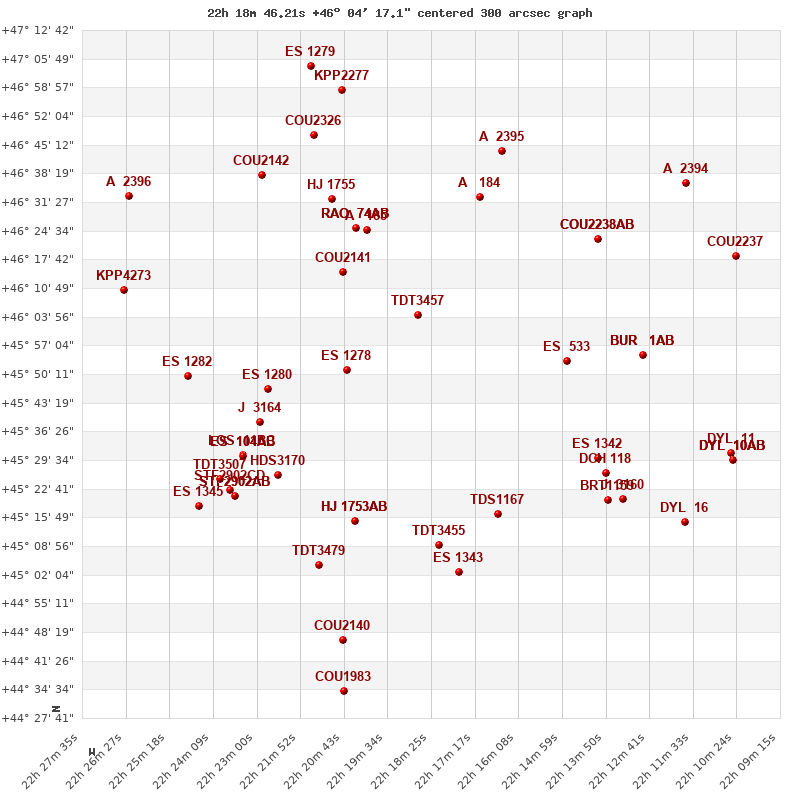
Click on the map to see the double of your interest.
Pass over with the mouse cursor to display the catalog designation.
|
| Show |
name |
coord_2000 |
discov# |
comp |
pa |
sep |
dist(') |
| Show |
|
22188+4604 |
TDT3457 |
|
246 |
0.5 |
|
| Show |
|
22207+4615 |
COU2141 |
|
211 |
0.9 |
23 |
| Show |
|
22206+4551 |
ES 1278 |
|
78 |
8.4 |
24 |
| Show |
|
22201+4625 |
A 185 |
|
137 |
0.8 |
25 |
| Show |
|
22204+4625 |
RAO 74 |
AB |
122 |
15.3 |
27 |
| Show |
|
22204+4625 |
RAO 74 |
AC |
231 |
30.7 |
27 |
| Show |
|
22171+4633 |
A 184 |
|
317 |
2.6 |
33 |
| Show |
|
22210+4632 |
HJ 1755 |
|
6 |
47.6 |
37 |
| Show |
|
22149+4553 |
ES 533 |
|
315 |
4.5 |
43 |
| Show |
|
22227+4547 |
ES 1280 |
|
255 |
7.0 |
45 |
| Show |
|
22166+4644 |
A 2395 |
|
358 |
2.3 |
46 |
| Show |
|
22230+4539 |
J 3164 |
|
215 |
5.1 |
51 |
| Show |
|
22214+4646 |
COU2326 |
|
282 |
0.4 |
52 |
| Show |
|
22204+4514 |
HJ 1753 |
AB |
182 |
5.0 |
53 |
| Show |
|
22204+4514 |
HJ 1753 |
AC |
175 |
42.2 |
53 |
| Show |
|
22141+4623 |
COU2238 |
AB |
64 |
1.3 |
53 |
| Show |
|
22141+4623 |
GII 88 |
AC |
69 |
5.1 |
53 |
| Show |
|
22167+4517 |
TDS1167 |
|
43 |
1.1 |
53 |
| Show |
|
22229+4637 |
COU2142 |
|
117 |
0.6 |
55 |
| Show |
|
22224+4526 |
HDS3170 |
|
118 |
0.1 |
55 |
| Show |
|
22182+4509 |
TDT3455 |
|
13 |
1.9 |
56 |
| Show |
|
22208+4658 |
KPP2277 |
|
177 |
19.2 |
58 |
| Show |
|
22234+4531 |
LOS 11 |
BC |
199 |
2.7 |
59 |
| Show |
|
22234+4531 |
ES 104 |
AB |
30 |
8.1 |
59 |
| Show |
|
22234+4531 |
LOS 11 |
AC |
36 |
5.4 |
59 |
| Show |
|
22141+4531 |
ES 1342 |
|
206 |
4.1 |
60 |
| Show |
|
22129+4555 |
BUR 1 |
AB |
196 |
13.5 |
63 |
| Show |
|
22129+4555 |
BUR 1 |
AC |
195 |
35.1 |
63 |
| Show |
|
22176+4503 |
ES 1343 |
|
74 |
1.7 |
63 |
| Show |
|
22138+4526 |
DCH 118 |
|
16 |
1.5 |
65 |
| Show |
|
22248+4550 |
ES 1282 |
|
57 |
4.6 |
65 |
| Show |
|
22214+4504 |
TDT3479 |
|
273 |
2.2 |
66 |
| Show |
|
22236+4521 |
STF2902 |
AB |
88 |
6.5 |
67 |
| Show |
|
22236+4521 |
STF2902 |
AC |
47 |
124.2 |
67 |
| Show |
|
22216+4704 |
ES 1279 |
|
302 |
5.8 |
67 |
| Show |
|
22236+4521 |
STF2902 |
CD |
73 |
8.0 |
67 |
| Show |
|
22240+4525 |
TDT3507 |
|
192 |
1.0 |
68 |
| Show |
|
22138+4520 |
BRT1159 |
|
234 |
4.5 |
69 |
| Show |
|
22135+4520 |
J 3160 |
|
65 |
5.9 |
72 |
| Show |
|
22245+4518 |
ES 1345 |
|
297 |
2.6 |
76 |
| Show |
|
22117+4636 |
A 2394 |
|
161 |
2.3 |
80 |
| Show |
|
22265+4610 |
KPP4273 |
|
220 |
6.4 |
81 |
| Show |
|
22208+4446 |
COU2140 |
|
85 |
0.6 |
81 |
| Show |
|
22264+4633 |
A 2396 |
|
181 |
1.6 |
84 |
| Show |
|
22104+4619 |
COU2237 |
|
225 |
0.4 |
88 |
| Show |
|
22118+4515 |
DYL 16 |
|
317 |
6.7 |
89 |
| Show |
|
22105+4531 |
DYL 11 |
|
296 |
7.4 |
92 |
| Show |
|
22207+4434 |
COU1983 |
|
259 |
0.4 |
93 |
| Show |
|
22105+4530 |
DYL 10 |
AB |
271 |
54.4 |
94 |
| Show |
|
22105+4530 |
DYL 10 |
AC |
273 |
32.8 |
94 |
| Show |
|
22105+4530 |
DYL 10 |
AD |
312 |
42.0 |
94 |
|
|
WDS 22188+4604 : COMPONENTS
22188+4604 A
| Componente originario normalizzato |
AB |
|
Name |
HD 212029 |
|
Coord arcsec 2000 |
221846.21+460417.1 |
|
Mag |
10.86 |
|
| Spectral class |
G0 (yellow) |
|
PmRA |
0.00 |
|
PmDE |
4.0 |
|
Tycho2 |
3607-02544-1 |
|
| Tycho2 |
3607-02544-1 |
|
Pflag |
|
|
RAmdeg |
334.69245240 |
|
DEmdeg |
46.07139050 |
|
| PmRA |
0.2 |
|
PmDE |
3.8 |
|
E RAmdeg |
22 |
|
E DEmdeg |
23 |
|
| E pmRA |
1.3 |
|
E pmDE |
1.2 |
|
EpRAm |
1986.18 |
|
EpDEm |
1984.94 |
|
| Num |
8 |
|
Q RAmdeg |
1.6 |
|
Q DEmdeg |
1.2 |
|
Q pmRA |
1.6 |
|
| Q pmDE |
1.2 |
|
BTmag |
12.166 |
|
E BTmag |
0.114 |
|
VTmag |
10.264 |
|
| E VTmag |
0.032 |
|
Prox |
800 |
|
TYC |
T |
|
HIP |
|
|
| CCDM |
|
|
RAdeg |
334.69245167 |
|
DEdeg |
46.07138639 |
|
EpRA 1990 |
1.68 |
|
| EpDE 1990 |
1.67 |
|
E RAdeg |
26.5 |
|
E DEdeg |
29.2 |
|
Posflg |
|
|
| Corr |
0.1 |
|
22188+4604 B
| Componente originario normalizzato |
AB |
|
Coord arcsec 2000 |
221846.18+460416.9 |
|
Mag |
10.92 |
|
PmRA |
0.00 |
|
| PmDE |
4.0 |
|
Calc delta mag |
0.06 |
|
Calc coord |
yes |
|