18217-5657 TDT 816
18h 21m 42.64s -56° 56' 33.3" P.A. 250.00 sep 0.4 mag 10.20,10.55
| Coord 2000 |
18217-5657 |
|
Discov num |
TDT 816 |
|
Comp |
|
|
Coord arcsec 2000 |
18 21 42.64 -56 56 33.3 |
|
| Date first |
1991 |
|
Date last |
1991 |
|
Obs |
1 |
|
| Pa first |
250 |
|
Pa last |
249.6 |
|
P.A. Now (θ) |
249.6° |
|
| Sep first |
0.4 |
|
Sep last |
0.43 |
|
Sep. Now (ρ) |
0.43" |
|
| Mag pri |
10.20 |
|
Mag sec |
10.55 |
|
delta mag (ΔM) |
0.35 |
|
Spectral class |
|
|
| Pri motion ra |
+000 |
|
Sec motion ra |
+000 |
|
| Pri motion dec |
+005 |
|
Sec motion dec |
+005 |
|
| Notes |
|
|
Nature of this double is uncertain.
OTHER CATALOGS AND DESIGNATIONS
| Constellation |
Telescopium |
|
Tycho2 |
8752-00034-1 |
|
Gaia DR2 |
6648288041938415488 |
|
WDS 18217-5657 TDT 816 : NOTES
No records found.
REFERENCES
No records found.
WDS HISTORIC DATA
| coord_2000 |
discov_num |
comp |
epoch |
obs |
pa |
sep |
mag_pri |
mag_sec |
spectr |
notes |
coord_arcsec_2000 |
| 18217-5657 |
TDT 816 |
|
1991 |
1 |
250 |
0.4 |
10.20 |
10.55 |
|
|
182142.64-565633.3 |
If you need more information about this double, apply for a
data request form to the WDS.
WDS 18217-5657 TDT 816 : VISUAL OBSERVATIONS REPORTS
No records found.
WDS 18217-5657 TDT 816 : MEASURES
No records found.
WDS 18217-5657 : VIRTUAL EYEPIECE

Click on the map to see the double of your interest.
Pass over with the mouse cursor to display the catalog designation.
|
|
WDS 18217-5657 : ALADIN DSS IMAGE @ 18h 21m 42.64s -56° 56' 33.3"
WDS 18217-5657 TDT 816 : NEIGHBORHOODS
|
|
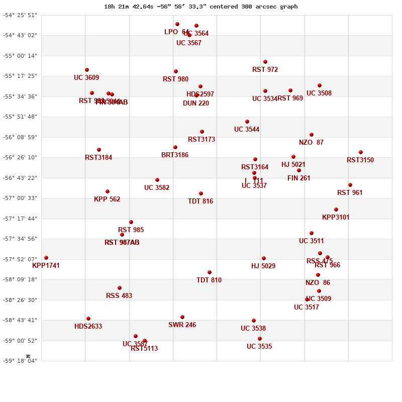
Click on the map to see the double of your interest.
Pass over with the mouse cursor to display the catalog designation.
|
| Show |
name |
coord_2000 |
discov# |
comp |
pa |
sep |
dist(') |
| Show |
|
18217-5657 |
TDT 816 |
|
250 |
0.4 |
|
| Show |
|
18263-5645 |
UC 3582 |
|
177 |
3.9 |
40 |
| Show |
|
18245-5617 |
BRT3186 |
|
75 |
4.8 |
45 |
| Show |
|
18161-5643 |
UC 3537 |
|
238 |
55.7 |
48 |
| Show |
|
18161-5639 |
I 111 |
|
287 |
1.0 |
50 |
| Show |
|
18216-5604 |
RST3173 |
|
292 |
1.6 |
53 |
| Show |
|
18160-5628 |
RST3164 |
|
263 |
0.7 |
55 |
| Show |
|
18290-5721 |
RST 985 |
|
181 |
1.1 |
65 |
| Show |
|
18208-5803 |
TDT 810 |
|
68 |
0.6 |
68 |
| Show |
|
18169-5556 |
UC 3544 |
|
285 |
44.8 |
73 |
| Show |
|
18299-5731 |
RST 987 |
AB |
340 |
1.1 |
76 |
| Show |
|
18299-5731 |
HDO 290 |
AC |
124 |
29.6 |
76 |
| Show |
|
18299-5731 |
SKF 973 |
AD |
273 |
137.5 |
76 |
| Show |
|
18151-5751 |
HJ 5029 |
|
79 |
1.8 |
77 |
| Show |
|
18315-5655 |
KPP 562 |
|
231 |
5.3 |
80 |
| Show |
|
18222-5534 |
DUN 220 |
|
177 |
31.2 |
83 |
| Show |
|
18120-5626 |
HJ 5021 |
|
326 |
4.6 |
86 |
| Show |
|
18115-5637 |
FIN 261 |
|
214 |
3.2 |
87 |
| Show |
|
18218-5526 |
HDS2597 |
|
173 |
0.1 |
91 |
| Show |
|
18324-5620 |
RST3184 |
|
137 |
0.5 |
96 |
| Show |
|
18102-5730 |
UC 3511 |
|
352 |
23.5 |
100 |
| Show |
|
18150-5530 |
UC 3534 |
|
83 |
23.4 |
104 |
| Show |
|
18302-5816 |
RSS 483 |
|
335 |
53.9 |
106 |
| Show |
|
18243-5513 |
RST 980 |
|
14 |
1.1 |
106 |
| Show |
|
18237-5841 |
SWR 246 |
|
254 |
10.9 |
106 |
| Show |
|
18101-5607 |
NZO 87 |
|
121 |
8.3 |
108 |
| Show |
|
18092-5747 |
RSS 475 |
|
330 |
9.7 |
113 |
| Show |
|
18310-5533 |
FIN 304 |
AB |
71 |
1.3 |
114 |
| Show |
|
18310-5533 |
I 1113 |
AC |
14 |
3.8 |
114 |
| Show |
|
18076-5710 |
KPP3101 |
|
74 |
5.2 |
117 |
| Show |
|
18162-5844 |
UC 3538 |
|
114 |
101.2 |
117 |
| Show |
|
18313-5532 |
HJ 5044 |
|
353 |
14.4 |
117 |
| Show |
|
18124-5530 |
RST 969 |
|
94 |
1.9 |
117 |
| Show |
|
18085-5750 |
RST 966 |
|
295 |
2.7 |
120 |
| Show |
|
18095-5805 |
NZO 86 |
|
176 |
6.2 |
121 |
| Show |
|
18149-5505 |
RST 972 |
|
216 |
0.7 |
125 |
| Show |
|
18106-5826 |
UC 3517 |
|
343 |
135.7 |
127 |
| Show |
|
18332-5532 |
RST 989 |
|
286 |
0.9 |
128 |
| Show |
|
18061-5649 |
RST 961 |
|
219 |
1.7 |
129 |
| Show |
|
18094-5819 |
UC 3509 |
|
91 |
86.4 |
129 |
| Show |
|
18285-5857 |
UC 3587 |
|
297 |
33.5 |
133 |
| Show |
|
18155-5859 |
UC 3535 |
|
37 |
79.5 |
133 |
| Show |
|
18276-5902 |
RST5113 |
|
116 |
0.7 |
134 |
| Show |
|
18229-5443 |
UC 3567 |
|
155 |
31.6 |
135 |
| Show |
|
18093-5525 |
UC 3508 |
|
112 |
62.1 |
138 |
| Show |
|
18335-5843 |
HDS2633 |
|
196 |
1.2 |
142 |
| Show |
|
18379-5751 |
KPP1741 |
|
26 |
13.4 |
142 |
| Show |
|
18222-5435 |
UC 3564 |
|
157 |
32.9 |
142 |
| Show |
|
18050-5622 |
RST3150 |
|
106 |
1.0 |
143 |
| Show |
|
18336-5512 |
UC 3609 |
|
27 |
9.5 |
145 |
| Show |
|
18242-5434 |
LPO 64 |
|
177 |
3.0 |
145 |
|
|
WDS 18217-5657 : COMPONENTS
18217-5657 A
| Componente originario normalizzato |
AB |
|
Coord arcsec 2000 |
182142.64-565633.3 |
|
Mag |
10.2 |
|
PmRA |
0.00 |
|
| PmDE |
5.0 |
|
Tycho2 |
8752-00034-1 |
|
| Tycho2 |
8752-00034-1 |
|
Pflag |
|
|
RAmdeg |
275.42759697 |
|
DEmdeg |
-56.94259301 |
|
| PmRA |
-0.1 |
|
PmDE |
4.6 |
|
E RAmdeg |
17 |
|
E DEmdeg |
20 |
|
| E pmRA |
1.5 |
|
E pmDE |
1.5 |
|
EpRAm |
1987.19 |
|
EpDEm |
1985.09 |
|
| Num |
8 |
|
Q RAmdeg |
1.1 |
|
Q DEmdeg |
1.2 |
|
Q pmRA |
1.1 |
|
| Q pmDE |
1.3 |
|
BTmag |
10.882 |
|
E BTmag |
0.050 |
|
VTmag |
9.707 |
|
| E VTmag |
0.027 |
|
Prox |
999 |
|
TYC |
T |
|
HIP |
|
|
| CCDM |
|
|
RAdeg |
275.42759833 |
|
DEdeg |
-56.94260444 |
|
EpRA 1990 |
1.68 |
|
| EpDE 1990 |
1.58 |
|
E RAdeg |
19.2 |
|
E DEdeg |
22.8 |
|
Posflg |
|
|
| Corr |
0.0 |
|
18217-5657 B
| Componente originario normalizzato |
AB |
|
Coord arcsec 2000 |
182142.61-565633.4 |
|
Mag |
10.55 |
|
PmRA |
0.00 |
|
| PmDE |
5.0 |
|
Calc delta mag |
0.35 |
|
Calc coord |
yes |
|