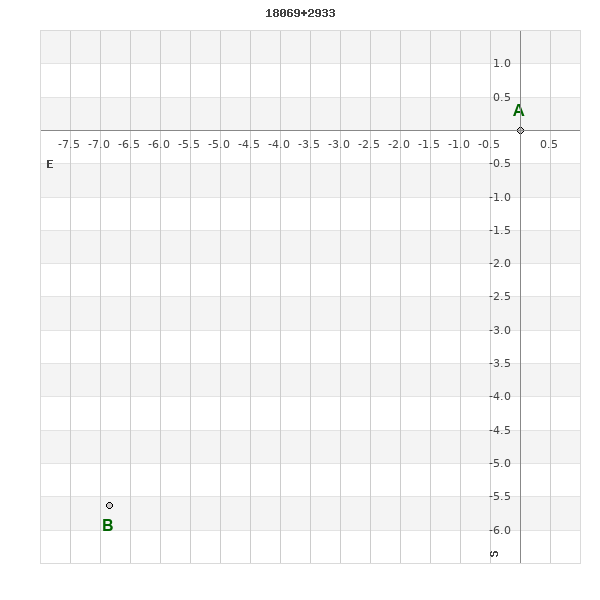
18069+2933 SLE 135
18h 06m 54.38s +29° 33' 09.1" P.A. 126.00 sep 9.7 mag 10.97,10.98
| Coord 2000 |
18069+2933 |
|
Discov num |
SLE 135 |
|
Comp |
|
|
Coord arcsec 2000 |
18 06 54.38 +29 33 09.1 |
|
| Date first |
1900 |
|
Date last |
2018 |
|
Obs |
16 |
|
| Pa first |
127 |
|
Pa last |
125.6 |
|
P.A. Now (θ) |
125.6° |
|
| Sep first |
7.5 |
|
Sep last |
9.676 |
|
Sep. Now (ρ) |
9.676" |
|
| Mag pri |
10.97 |
|
Mag sec |
10.98 |
|
delta mag (ΔM) |
0.01 |
|
Spectral class |
|
|
| Pri motion ra |
-006 |
|
Sec motion ra |
+006 |
|
| Pri motion dec |
-007 |
|
Sec motion dec |
-017 |
|
| Notes |
|
|
rPM=0.866
This double is not physical.
OTHER CATALOGS AND DESIGNATIONS
| Constellation |
Hercules |
|
Tycho2 |
2103-00677-2 |
|
Gaia DR2 |
4590363228088795264 |
|
WDS 18069+2933 SLE 135 : NOTES
No records found.
REFERENCES
| refcode |
metd |
author |
reference |
| Sle1966 |
Mc j |
Soulie, G. |
1966JO.....49..359S |
| Sle1966 |
+Pa |
J. Obs. 49, 359, 1966 |
|
| Sle1983 |
Pa - |
Soulie, G. |
1983A&AS...54..281S |
| Sle1983 |
|
A&AS 54, 281, 1983 |
|
| Sle1984 |
Pa - |
Soulie, G. |
1984A&AS...56..351S |
| Sle1984 |
|
A&AS 56, 351, 1984 |
|
| Sle1985 |
Pa - |
Soulie, G. |
1985A&AS...61...17S |
| Sle1985 |
|
A&AS 61, 17, 1985 |
|
| Sle1986a |
Pa - |
Soulie, G. |
. |
| Sle1986a |
|
Bull. Inf. Cent. Donnes Stell. #30, 91, 1986 |
|
| Sle1986b |
Pa - |
Soulie, G. |
. |
| Sle1986b |
|
Bull. Inf. Cent. Donnes Stell. #30, 103, 1986 |
|
| Sle2003 |
C j |
Soulie, G. |
2003O&T....56...10S |
| Sle2003 |
|
Obs. et Travaux 56, 10, 2003 |
|
| Sle2006 |
Pa - |
Soulie, G. |
2006O&T....62...26S |
| Sle2006 |
|
Obs. et Travaux 62, 26, 2006 |
|
| Sle2006b |
Pa j |
Soulie, G. |
2006O&T....63...15S |
| Sle2006b |
|
Obs. et Travaux 63, 15, 2006 |
|
| Sle2007 |
C j |
Soulie, G. |
2007O&T....65...34S |
| Sle2007 |
|
Obs. et Travaux 65, 34, 2007 |
|
WDS HISTORIC DATA
| coord_2000 |
discov_num |
comp |
epoch |
obs |
pa |
sep |
mag_pri |
mag_sec |
spectr |
notes |
coord_arcsec_2000 |
| 18069+2933 |
SLE 135 |
|
2002 |
6 |
126 |
9.3 |
10.97 |
10.98 |
|
D |
180654.38+293309.1 |
| 18069+2933 |
SLE 135 |
|
2010 |
8 |
126 |
9.3 |
10.97 |
10.98 |
|
|
180654.38+293309.1 |
| 18069+2933 |
SLE 135 |
|
2017 |
9 |
127 |
9.4 |
10.97 |
10.98 |
|
|
180654.38+293309.1 |
| 18069+2933 |
SLE 135 |
|
2018 |
11 |
127 |
9.4 |
10.97 |
10.98 |
|
|
180654.38+293309.1 |
If you need more information about this double, apply for a
data request form to the WDS.
WDS 18069+2933 SLE 135 : VISUAL OBSERVATIONS REPORTS
No records found.
WDS 18069+2933 SLE 135 : MEASURES
No records found.
WDS 18069+2933 : VIRTUAL EYEPIECE
Click on the map to see the double of your interest.
Pass over with the mouse cursor to display the catalog designation.
|
|
WDS 18069+2933 : ALADIN DSS IMAGE @ 18h 06m 54.38s +29° 33' 09.1"
WDS 18069+2933 SLE 135 : NEIGHBORHOODS
|
|
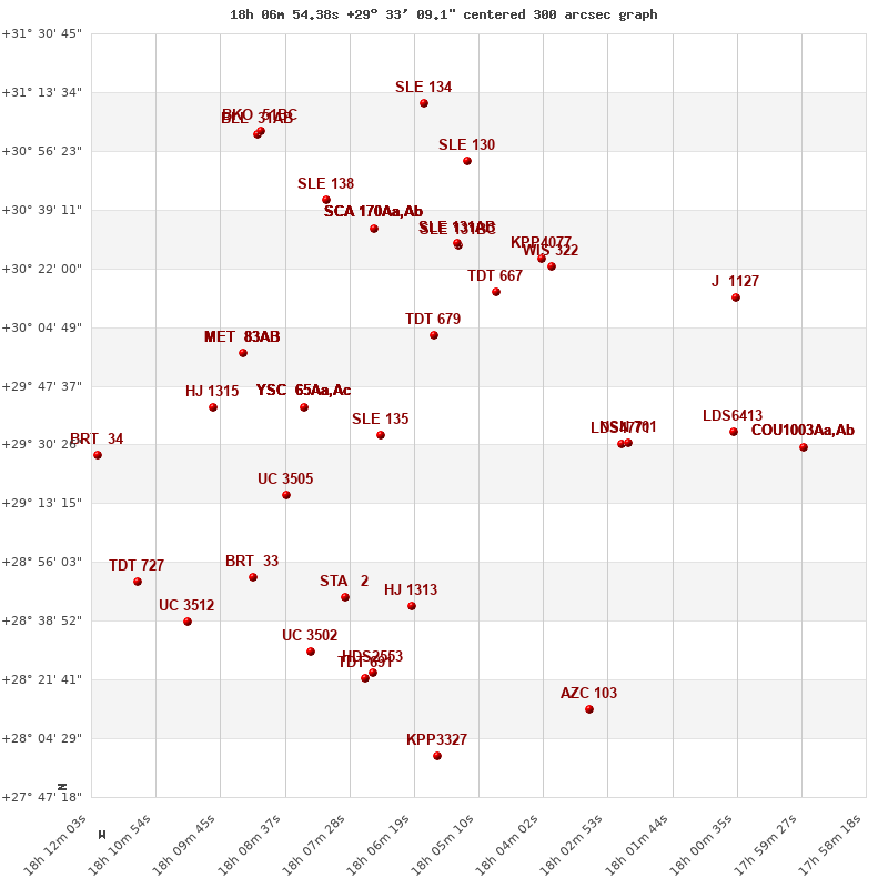
Click on the map to see the double of your interest.
Pass over with the mouse cursor to display the catalog designation.
|
| Show |
name |
coord_2000 |
discov# |
comp |
pa |
sep |
dist(') |
| Show |
|
18069+2933 |
SLE 135 |
|
126 |
9.7 |
|
| Show |
|
18083+2941 |
YSC 65 |
Aa,Ac |
246 |
0.1 |
20 |
| Show |
|
18083+2941 |
LAF 60 |
Aa,Ab |
251 |
0.1 |
20 |
| Show |
|
18083+2941 |
LAF 60 |
AB |
53 |
10.4 |
20 |
| Show |
|
18083+2941 |
LAF 60 |
AC |
196 |
11.2 |
20 |
| Show |
|
18083+2941 |
LAF 60 |
AD |
168 |
13.4 |
20 |
| Show |
|
18083+2941 |
LAF 60 |
AE |
262 |
16.3 |
20 |
| Show |
|
18086+2916 |
UC 3505 |
|
255 |
42.2 |
29 |
| Show |
|
18060+3002 |
TDT 679 |
|
347 |
0.7 |
32 |
| Show |
|
18099+2941 |
HJ 1315 |
|
129 |
9.0 |
40 |
| Show |
|
18094+2957 |
MET 83 |
AB |
274 |
2.7 |
40 |
| Show |
|
18094+2957 |
MET 83 |
AC |
239 |
3.3 |
40 |
| Show |
|
18094+2957 |
MET 83 |
AD |
183 |
9.5 |
40 |
| Show |
|
18094+2957 |
MET 83 |
AE |
281 |
10.4 |
40 |
| Show |
|
18094+2957 |
GAT 25 |
AF |
301 |
29.2 |
40 |
| Show |
|
18075+2846 |
STA 2 |
|
87 |
0.1 |
49 |
| Show |
|
18049+3015 |
TDT 667 |
|
146 |
1.5 |
50 |
| Show |
|
18063+2843 |
HJ 1313 |
|
297 |
13.7 |
51 |
| Show |
|
18090+2851 |
BRT 33 |
|
110 |
3.5 |
52 |
| Show |
|
18026+2931 |
LDS4771 |
|
251 |
16.6 |
56 |
| Show |
|
18025+2931 |
NSN 701 |
|
266 |
16.5 |
58 |
| Show |
|
18054+3029 |
SLE 131 |
BC |
217 |
15.0 |
59 |
| Show |
|
18054+3029 |
SLE 131 |
AB |
203 |
52.4 |
59 |
| Show |
|
18054+3029 |
SLE 131 |
AC |
206 |
67.2 |
59 |
| Show |
|
18070+3034 |
SCA 170 |
Aa,Ab |
230 |
0.2 |
61 |
| Show |
|
18070+3034 |
AC 15 |
AB |
331 |
1.4 |
61 |
| Show |
|
18070+3034 |
AC 15 |
AC |
60 |
97.0 |
61 |
| Show |
|
18070+3034 |
AC 15 |
AD |
103 |
140.1 |
61 |
| Show |
|
18070+3034 |
AC 15 |
AE |
78 |
169.9 |
61 |
| Show |
|
18070+3034 |
AC 15 |
AF |
165 |
162.4 |
61 |
| Show |
|
18070+3034 |
AC 15 |
AG |
|
175.9 |
61 |
| Show |
|
18039+3023 |
WIS 322 |
|
284 |
999.9 |
64 |
| Show |
|
18041+3025 |
KPP4077 |
|
249 |
16.8 |
64 |
| Show |
|
18082+2830 |
UC 3502 |
|
249 |
20.1 |
66 |
| Show |
|
18119+2927 |
BRT 34 |
|
164 |
5.4 |
66 |
| Show |
|
18070+2824 |
HDS2553 |
|
300 |
0.1 |
70 |
| Show |
|
18079+3042 |
SLE 138 |
|
329 |
10.1 |
70 |
| Show |
|
18103+2839 |
UC 3512 |
|
28 |
28.3 |
71 |
| Show |
|
18112+2850 |
TDT 727 |
|
343 |
0.4 |
72 |
| Show |
|
18072+2822 |
TDT 691 |
|
201 |
0.9 |
72 |
| Show |
|
18006+2934 |
LDS6413 |
|
105 |
88.1 |
82 |
| Show |
|
18054+3054 |
SLE 130 |
|
103 |
6.7 |
83 |
| Show |
|
18006+3014 |
J 1127 |
|
341 |
2.9 |
92 |
| Show |
|
18091+3101 |
BLL 31 |
AB |
320 |
64.5 |
93 |
| Show |
|
18091+3101 |
BKO 51 |
BC |
207 |
19.0 |
94 |
| Show |
|
18032+2813 |
AZC 103 |
|
146 |
14.1 |
94 |
| Show |
|
18059+2759 |
KPP3327 |
|
166 |
2.9 |
95 |
| Show |
|
18061+3110 |
SLE 134 |
|
292 |
7.2 |
98 |
| Show |
|
17594+2929 |
COU1003 |
Aa,Ab |
359 |
0.1 |
98 |
| Show |
|
17594+2929 |
STF2247 |
AB |
188 |
11.6 |
98 |
| Show |
|
17594+2929 |
WAL 88 |
AC |
230 |
56.1 |
98 |
|
|
WDS 18069+2933 : COMPONENTS
18069+2933 A
| Componente originario normalizzato |
AB |
|
Coord arcsec 2000 |
180654.38+293309.1 |
|
Mag |
10.97 |
|
PmRA |
-6.00 |
|
| PmDE |
-7.0 |
|
Tycho2 |
2103-00677-1 |
|
| Tycho2 |
2103-00677-1 |
|
Pflag |
|
|
RAmdeg |
271.72896037 |
|
DEmdeg |
29.55099836 |
|
| PmRA |
0.5 |
|
PmDE |
-18.5 |
|
E RAmdeg |
45 |
|
E DEmdeg |
45 |
|
| E pmRA |
2.5 |
|
E pmDE |
2.4 |
|
EpRAm |
1987.79 |
|
EpDEm |
1987.60 |
|
| Num |
3 |
|
Q RAmdeg |
1.9 |
|
Q DEmdeg |
0.6 |
|
Q pmRA |
1.9 |
|
| Q pmDE |
0.6 |
|
BTmag |
12.099 |
|
E BTmag |
0.110 |
|
VTmag |
10.984 |
|
| E VTmag |
0.061 |
|
Prox |
91 |
|
TYC |
T |
|
HIP |
|
|
| CCDM |
|
|
RAdeg |
271.72895861 |
|
DEdeg |
29.55104139 |
|
EpRA 1990 |
1.67 |
|
| EpDE 1990 |
1.63 |
|
E RAdeg |
45.5 |
|
E DEdeg |
46.2 |
|
Posflg |
|
|
| Corr |
0.0 |
|
18069+2933 B
| Componente originario normalizzato |
AB |
|
Coord arcsec 2000 |
180654.90+293303.5 |
|
Mag |
10.98 |
|
PmRA |
6.00 |
|
| PmDE |
-17.0 |
|
Calc delta mag |
0.01 |
|
Calc coord |
yes |
|