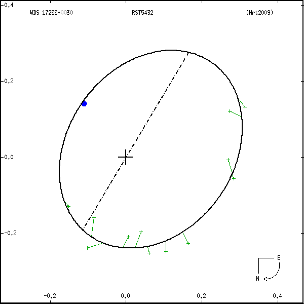
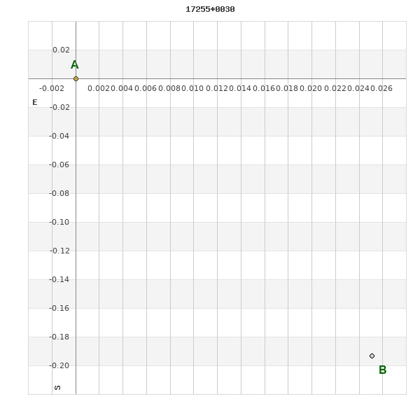
17255+0030 RST 5432
17h 25m 30.20s +00° 29' 58.0" P.A. 187.00 sep 0.2 mag 10.50,10.50 Sp K0
| Coord 2000 |
17255+0030 |
|
Discov num |
RST5432 |
|
Comp |
|
|
Coord arcsec 2000 |
17 25 30.20 +00 29 58.0 |
|
| Date first |
1946 |
|
Date last |
2013 |
|
Obs |
15 |
|
| Pa first |
293 |
|
Pa last |
187.4 |
|
P.A. Now (θ) |
187.4° |
|
| Sep first |
0.3 |
|
Sep last |
0.195 |
|
Sep. Now (ρ) |
0.195" |
|
| Mag pri |
10.50 |
|
Mag sec |
10.50 |
|
delta mag (ΔM) |
0 |
|
Spectral class |
K0 (yellow-orange) |
|
| Pri motion ra |
+009 |
|
Sec motion ra |
|
|
| Pri motion dec |
+001 |
|
Sec motion dec |
|
|
| Notes |
O
(Orbital solution) |
|
This double is physical.
OTHER CATALOGS AND DESIGNATIONS
| Constellation |
Ophiuchus |
|
Tycho2 |
0401-00825-1 |
|
ORBITAL ELEMENTS
| Period (P) | 93.98y | ± 4.89 |
Periastron (T) | 1998.34y | ± 1.97 |
Semi-major axis (a) | 0.285a | ± 0.011 |
| Eccentricity (e) | 0.274 | ± 0.024 |
Inclination (i) | 141.6° | ± 5.6 |
Longitude of periastron (ω) | 228.5° | ± 15.3 |
| Node (Ω) | 149.2° | ± 9.5 |
Notes | | |
Reference | Hrt2009 | |
| Equinox | | |
Last observation | 2007 | |
Grade | 4 | (1=Definitive, 9=Indet.) |
| label |
theta |
rho |
| 2000 |
275.5 |
0.175 |
| 2001 |
267.7 |
0.172 |
| 2002 |
259.6 |
0.170 |
| 2003 |
251.4 |
0.169 |
| 2004 |
243.3 |
0.170 |
| 2005 |
235.3 |
0.173 |
| 2006 |
227.6 |
0.177 |
| 2007 |
220.4 |
0.183 |
| 2008 |
213.7 |
0.190 |
| 2009 |
207.4 |
0.198 |
| 2010 |
201.7 |
0.206 |
| 2011 |
196.4 |
0.215 |
| 2012 |
191.5 |
0.224 |
| 2013 |
187.0 |
0.233 |
| 2014 |
182.9 |
0.243 |
| 2015 |
179.1 |
0.252 |
| 2016 |
175.5 |
0.260 |
| 2017 |
172.1 |
0.269 |
| 2018 |
169.0 |
0.277 |
| 2019 |
166.0 |
0.284 |
| 2020 |
163.1 |
0.291 |
| 2021 |
160.4 |
0.298 |
| 2022 |
157.9 |
0.304 |
| 2023 |
155.4 |
0.310 |
| 2024 |
153.0 |
0.315 |
| 2025 |
150.6 |
0.319 |
| 2026 |
148.4 |
0.324 |
| 2027 |
146.1 |
0.327 |
| 2028 |
144.0 |
0.330 |
| 2029 |
141.8 |
0.333 |
| 2030 |
139.7 |
0.335 |
|
|
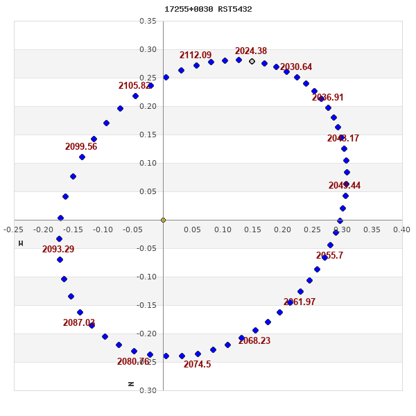
Note: Theta is PA, Rho is Sep. For yearly orbits, data refer to Jan 1st.
|
|
|
|
|
|
|
|
Measures: green=micrometric, blue=interferometric, purple=photographic |
|
WDS 17255+0030 RST 5432 : NOTES
No records found.
REFERENCES
| refcode |
metd |
author |
reference |
| Hrt2009 |
Su j |
Hartkopf, W.I. & Mason, B.D. |
2009AJ....138..813H |
| Hrt2009 |
+orb |
AJ 138, 813, 2009 |
|
DISCOVERER
| idgroup |
discov |
author |
| 1 |
RST |
Rossiter, R.A. |
WDS HISTORIC DATA
| coord_2000 |
discov_num |
comp |
epoch |
obs |
pa |
sep |
mag_pri |
mag_sec |
spectr |
notes |
coord_arcsec_2000 |
| 17255+0030 |
RST5432 |
|
1995 |
12 |
311 |
0.2 |
10.50 |
10.50 |
K0 |
NO |
172530.20+002958.0 |
| 17255+0030 |
RST5432 |
|
2007 |
13 |
218 |
0.2 |
10.50 |
10.50 |
K0 |
NO |
172530.20+002958.0 |
| 17255+0030 |
RST5432 |
|
2011 |
14 |
187 |
0.2 |
10.50 |
10.50 |
K0 |
O |
172530.20+002958.0 |
| 17255+0030 |
RST5432 |
|
2013 |
15 |
187 |
0.2 |
10.50 |
10.50 |
K0 |
O |
172530.20+002958.0 |
If you need more information about this double, apply for a
data request form to the WDS.
WDS 17255+0030 RST 5432 : VISUAL OBSERVATIONS REPORTS
No records found.
WDS 17255+0030 RST 5432 : MEASURES
No records found.
WDS 17255+0030 : VIRTUAL EYEPIECE
Click on the map to see the double of your interest.
Pass over with the mouse cursor to display the catalog designation.
|
|
WDS 17255+0030 : ALADIN DSS IMAGE @ 17h 25m 30.20s +00° 29' 58.0"
WDS 17255+0030 RST 5432 : NEIGHBORHOODS
|
|
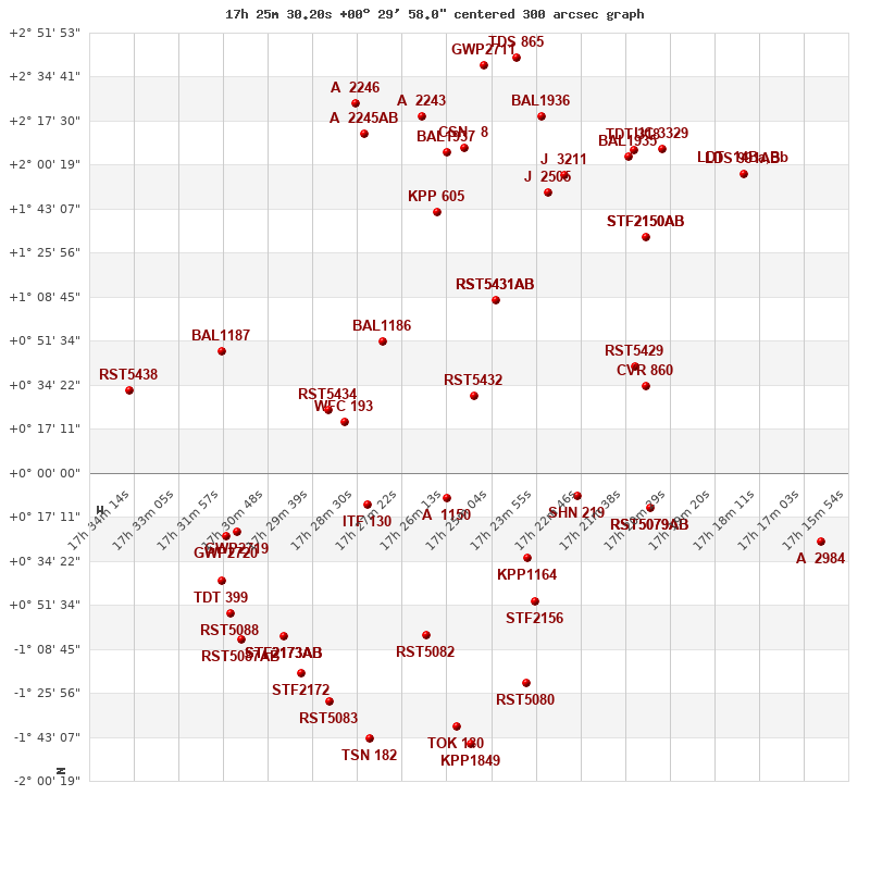
Click on the map to see the double of your interest.
Pass over with the mouse cursor to display the catalog designation.
|
| Show |
name |
coord_2000 |
discov# |
comp |
pa |
sep |
dist(') |
| Show |
|
17255+0030 |
RST5432 |
|
187 |
0.2 |
1 |
| Show |
|
17241-0033 |
KPP1164 |
|
202 |
9.1 |
21 |
| Show |
|
17262-0010 |
A 1150 |
|
124 |
2.7 |
23 |
| Show |
|
17240-0050 |
STF2156 |
|
36 |
3.8 |
31 |
| Show |
|
17250+0108 |
RST5431 |
AB |
161 |
2.7 |
39 |
| Show |
|
17250+0108 |
SCA 199 |
Aa,Ab |
159 |
0.2 |
39 |
| Show |
|
17279+0051 |
BAL1186 |
|
116 |
8.3 |
42 |
| Show |
|
17282-0013 |
ITF 130 |
|
45 |
2.7 |
45 |
| Show |
|
17229-0009 |
SHN 219 |
|
-1 |
0.1 |
45 |
| Show |
|
17288+0020 |
WFC 193 |
|
316 |
46.8 |
51 |
| Show |
|
17292+0025 |
RST5434 |
|
161 |
1.5 |
57 |
| Show |
|
17214+0042 |
RST5429 |
|
305 |
1.6 |
63 |
| Show |
|
17211+0034 |
CVR 860 |
|
78 |
26.9 |
67 |
| Show |
|
17210-0014 |
RST5079 |
AB |
63 |
1.3 |
70 |
| Show |
|
17210-0014 |
GII 245 |
Aa,Ab |
119 |
0.1 |
70 |
| Show |
|
17265+0142 |
KPP 605 |
|
194 |
5.6 |
74 |
| Show |
|
17236+0149 |
J 2505 |
|
137 |
1.6 |
85 |
| Show |
|
17211+0127 |
STF2150 |
AB |
214 |
11.7 |
91 |
| Show |
|
17211+0127 |
STF2150 |
AC |
56 |
160.8 |
91 |
| Show |
|
17316-0023 |
GWP2719 |
|
111 |
48.2 |
92 |
| Show |
|
17230+0157 |
J 3211 |
|
144 |
4.0 |
93 |
| Show |
|
17268-0104 |
RST5082 |
|
284 |
1.5 |
96 |
| Show |
|
17262+0205 |
BAL1937 |
|
204 |
12.0 |
96 |
| Show |
|
17319-0025 |
GWP2720 |
|
302 |
191.9 |
96 |
| Show |
|
17258+0207 |
CSN 8 |
|
269 |
7.3 |
97 |
| Show |
|
17318-0055 |
RST5088 |
|
58 |
1.2 |
98 |
| Show |
|
17320-0042 |
TDT 399 |
|
134 |
0.4 |
99 |
| Show |
|
17320+0047 |
BAL1187 |
|
272 |
3.6 |
99 |
| Show |
|
17283+0212 |
A 2245 |
AB |
351 |
2.1 |
111 |
| Show |
|
17215+0203 |
BAL1935 |
|
26 |
18.7 |
111 |
| Show |
|
17269+0219 |
A 2243 |
|
301 |
2.0 |
112 |
| Show |
|
17238+0219 |
BAL1936 |
|
315 |
3.4 |
113 |
| Show |
|
17242-0124 |
RST5080 |
|
25 |
3.1 |
114 |
| Show |
|
17214+0206 |
TDT 318 |
|
17 |
0.4 |
114 |
| Show |
|
17304-0104 |
STF2173 |
AB |
104 |
0.2 |
120 |
| Show |
|
17304-0104 |
CSN 9 |
AC |
241 |
13.7 |
120 |
| Show |
|
17304-0104 |
CSN 9 |
AD |
317 |
16.9 |
120 |
| Show |
|
17207+0207 |
UC 3329 |
|
304 |
32.2 |
121 |
| Show |
|
17285+0224 |
A 2246 |
|
120 |
0.4 |
124 |
| Show |
|
17299-0118 |
STF2172 |
|
171 |
11.4 |
128 |
| Show |
|
17253+0239 |
GWP2711 |
|
215 |
33.0 |
130 |
| Show |
|
17260-0139 |
TOK 180 |
|
301 |
6.0 |
130 |
| Show |
|
17315-0105 |
RST5087 |
AB |
100 |
1.6 |
131 |
| Show |
|
17292-0129 |
RST5083 |
|
349 |
1.0 |
132 |
| Show |
|
17344+0032 |
RST5438 |
|
76 |
1.4 |
133 |
| Show |
|
17244+0242 |
TDS 865 |
|
144 |
1.1 |
134 |
| Show |
|
17166-0027 |
A 2984 |
|
27 |
0.7 |
134 |
| Show |
|
17187+0157 |
LDT 14 |
Ba,Bb |
55 |
0.5 |
136 |
| Show |
|
17187+0157 |
LDS 991 |
AB |
139 |
13.0 |
136 |
| Show |
|
17256-0146 |
KPP1849 |
|
250 |
14.3 |
136 |
| Show |
|
17282-0144 |
TSN 182 |
|
23 |
0.1 |
140 |
|
|
WDS 17255+0030 : COMPONENTS
17255+0030 A
| Componente originario normalizzato |
AB |
|
Coord arcsec 2000 |
172530.20+002958.0 |
|
Mag |
10.5 |
|
Spectral class |
K0 (yellow-orange) |
|
| PmRA |
9.00 |
|
PmDE |
1.0 |
|
Tycho2 |
0401-00825-1 |
|
| Tycho2 |
0401-00825-1 |
|
Pflag |
|
|
RAmdeg |
261.37584053 |
|
DEmdeg |
0.49946235 |
|
| PmRA |
-2.7 |
|
PmDE |
4.9 |
|
E RAmdeg |
16 |
|
E DEmdeg |
18 |
|
| E pmRA |
1.3 |
|
E pmDE |
1.3 |
|
EpRAm |
1989.60 |
|
EpDEm |
1987.79 |
|
| Num |
7 |
|
Q RAmdeg |
1.1 |
|
Q DEmdeg |
0.4 |
|
Q pmRA |
1.2 |
|
| Q pmDE |
0.5 |
|
BTmag |
10.751 |
|
E BTmag |
0.038 |
|
VTmag |
9.856 |
|
| E VTmag |
0.025 |
|
Prox |
999 |
|
TYC |
T |
|
HIP |
|
|
| CCDM |
|
|
RAdeg |
261.37584694 |
|
DEdeg |
0.49945028 |
|
EpRA 1990 |
1.73 |
|
| EpDE 1990 |
1.61 |
|
E RAdeg |
16.0 |
|
E DEdeg |
20.1 |
|
Posflg |
|
|
| Corr |
0.0 |
|
| Ccdm |
17255+0030 |
|
RComp |
|
|
Comp |
A |
|
Note1 |
|
|
| Note2 |
|
|
Discov num |
|
|
DRAs |
0.20 |
|
DDEs |
-2.4 |
|
| R dRAs |
10 |
|
Year |
|
|
Theta |
|
|
Rho |
|
|
| Obs |
2 |
|
Vmag |
10.5 |
|
Sp |
K0 |
|
PmNote |
* |
|
| PmRA |
10 |
|
PmDE |
-2 |
|
Dm number |
+00 3685 |
|
Cat1 |
BD |
|
| Name2 |
+00 2069 |
|
Cat2 |
AGK2/3 |
|
HD |
|
|
M HD |
|
|
| ADS BDS |
|
|
M ADS BDS |
|
|
N IDS |
|
|
IDS |
17204N0035A |
|
| HIC |
|
|
17255+0030 B
| Componente originario normalizzato |
AB |
|
Coord arcsec 2000 |
172530.20+002957.8 |
|
Mag |
10.5 |
|
Calc coord |
yes |
|
| Ccdm |
17255+0030 |
|
RComp |
|
|
Comp |
B |
|
Note1 |
|
|
| Note2 |
|
|
Discov num |
RST5432 |
|
DRAs |
|
|
DDEs |
|
|
| R dRAs |
|
|
Year |
1946 |
|
Theta |
293 |
|
Rho |
0.3 |
|
| Obs |
2 |
|
Vmag |
10.5 |
|
Sp |
|
|
PmNote |
|
|
| PmRA |
|
|
PmDE |
|
|
Dm number |
|
|
Cat1 |
|
|
| Name2 |
|
|
Cat2 |
|
|
HD |
|
|
M HD |
|
|
| ADS BDS |
|
|
M ADS BDS |
|
|
N IDS |
|
|
IDS |
17204N0035B |
|
| HIC |
|
|