07040+1934 SLE 396 (HD 268513)
07h 03m 57.50s +19° 33' 37.0" P.A. 180.00 sep 23.4 mag 10.96,11.49
| Coord 2000 |
07040+1934 |
|
Discov num |
SLE 396 |
|
Comp |
|
|
Coord arcsec 2000 |
07 03 57.50 +19 33 37.0 |
|
| Date first |
1895 |
|
Date last |
2015 |
|
Obs |
12 |
|
| Pa first |
178 |
|
Pa last |
180.1 |
|
P.A. Now (θ) |
180.1° |
|
| Sep first |
22.6 |
|
Sep last |
23.372 |
|
Sep. Now (ρ) |
23.372" |
|
| Mag pri |
10.96 |
|
Mag sec |
11.49 |
|
delta mag (ΔM) |
0.53 |
|
Spectral class |
|
|
| Pri motion ra |
-002 |
|
Sec motion ra |
-012 |
|
| Pri motion dec |
+003 |
|
Sec motion dec |
-006 |
|
| Notes |
|
|
rPM=1.003
This double is not physical.
OTHER CATALOGS AND DESIGNATIONS
| Name |
HD 268513 |
|
Constellation |
Gemini |
|
Tycho2 |
1352-01028-1 |
|
Gaia DR2 |
3364980024559484544 |
|
| HD |
268513 |
|
WDS 07040+1934 SLE 396 (HD 268513) : NOTES
No records found.
REFERENCES
| refcode |
metd |
author |
reference |
| Sle1966 |
Mc j |
Soulie, G. |
1966JO.....49..359S |
| Sle1966 |
+Pa |
J. Obs. 49, 359, 1966 |
|
| Sle1983 |
Pa - |
Soulie, G. |
1983A&AS...54..281S |
| Sle1983 |
|
A&AS 54, 281, 1983 |
|
| Sle1984 |
Pa - |
Soulie, G. |
1984A&AS...56..351S |
| Sle1984 |
|
A&AS 56, 351, 1984 |
|
| Sle1985 |
Pa - |
Soulie, G. |
1985A&AS...61...17S |
| Sle1985 |
|
A&AS 61, 17, 1985 |
|
| Sle1986a |
Pa - |
Soulie, G. |
. |
| Sle1986a |
|
Bull. Inf. Cent. Donnes Stell. #30, 91, 1986 |
|
| Sle1986b |
Pa - |
Soulie, G. |
. |
| Sle1986b |
|
Bull. Inf. Cent. Donnes Stell. #30, 103, 1986 |
|
| Sle2003 |
C j |
Soulie, G. |
2003O&T....56...10S |
| Sle2003 |
|
Obs. et Travaux 56, 10, 2003 |
|
| Sle2006 |
Pa - |
Soulie, G. |
2006O&T....62...26S |
| Sle2006 |
|
Obs. et Travaux 62, 26, 2006 |
|
| Sle2006b |
Pa j |
Soulie, G. |
2006O&T....63...15S |
| Sle2006b |
|
Obs. et Travaux 63, 15, 2006 |
|
| Sle2007 |
C j |
Soulie, G. |
2007O&T....65...34S |
| Sle2007 |
|
Obs. et Travaux 65, 34, 2007 |
|
WDS HISTORIC DATA
| coord_2000 |
discov_num |
comp |
epoch |
obs |
pa |
sep |
mag_pri |
mag_sec |
spectr |
notes |
coord_arcsec_2000 |
| 07040+1934 |
SLE 396 |
|
1997 |
5 |
180 |
23.6 |
10.96 |
11.49 |
|
D |
070357.50+193337.0 |
| 07040+1934 |
SLE 396 |
|
2008 |
6 |
180 |
23.7 |
10.96 |
11.49 |
|
D |
070357.50+193337.0 |
| 07040+1934 |
SLE 396 |
|
2010 |
8 |
180 |
23.3 |
10.96 |
11.49 |
|
|
070357.50+193337.0 |
| 07040+1934 |
SLE 396 |
|
2015 |
9 |
180 |
23.4 |
10.96 |
11.49 |
|
|
070357.50+193337.0 |
If you need more information about this double, apply for a
data request form to the WDS.
WDS 07040+1934 SLE 396 (HD 268513) : VISUAL OBSERVATIONS REPORTS
No records found.
WDS 07040+1934 SLE 396 (HD 268513) : MEASURES
No records found.
WDS 07040+1934 (HD 268513) : VIRTUAL EYEPIECE
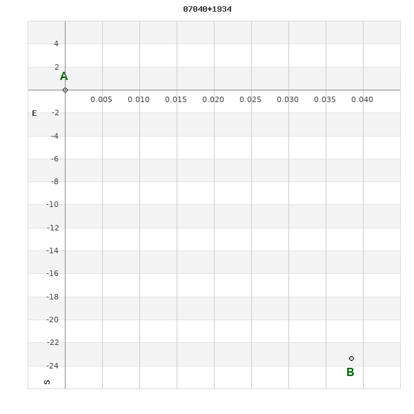
Click on the map to see the double of your interest.
Pass over with the mouse cursor to display the catalog designation.
|
|
WDS 07040+1934 (HD 268513) : ALADIN DSS IMAGE @ 07h 03m 57.50s +19° 33' 37.0"
WDS 07040+1934 SLE 396 (HD 268513) : NEIGHBORHOODS
|
|
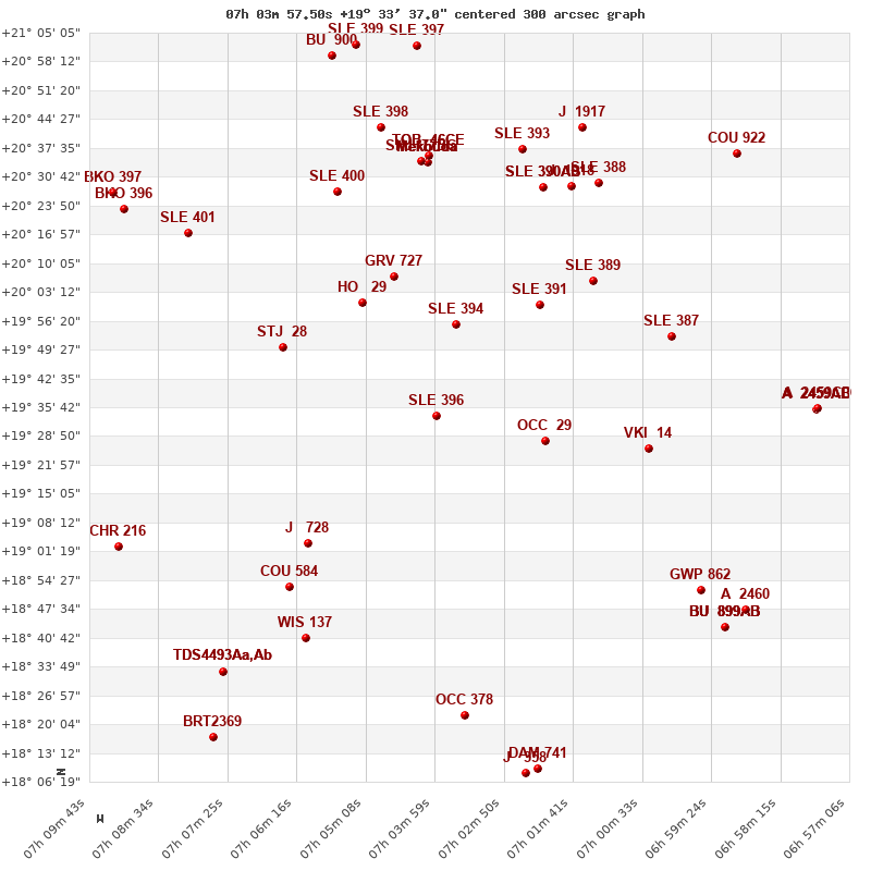
Click on the map to see the double of your interest.
Pass over with the mouse cursor to display the catalog designation.
|
| Show |
name |
coord_2000 |
discov# |
comp |
pa |
sep |
dist(') |
| Show |
|
07040+1934 |
SLE 396 |
|
180 |
23.4 |
|
| Show |
|
07036+1956 |
SLE 394 |
|
275 |
24.4 |
23 |
| Show |
|
07022+1928 |
OCC 29 |
|
-1 |
0.1 |
27 |
| Show |
|
07052+2001 |
HO 29 |
|
157 |
5.0 |
33 |
| Show |
|
07046+2006 |
GRV 727 |
|
180 |
31.9 |
35 |
| Show |
|
07022+2000 |
SLE 391 |
|
86 |
4.7 |
36 |
| Show |
|
07065+1950 |
STJ 28 |
|
88 |
1.4 |
40 |
| Show |
|
07061+1903 |
J 728 |
|
73 |
3.0 |
43 |
| Show |
|
07014+2006 |
SLE 389 |
|
28 |
16.6 |
49 |
| Show |
|
07004+1926 |
VKI 14 |
|
83 |
5.2 |
51 |
| Show |
|
07064+1853 |
COU 584 |
|
209 |
0.7 |
54 |
| Show |
|
07001+1953 |
SLE 387 |
|
113 |
8.0 |
59 |
| Show |
|
07056+2027 |
SLE 400 |
|
354 |
23.4 |
59 |
| Show |
|
07022+2028 |
SLE 390 |
AB |
24 |
16.3 |
60 |
| Show |
|
07022+2028 |
SLE 390 |
AC |
331 |
49.4 |
60 |
| Show |
Mekbuda |
07041+2034 |
SHJ 77 |
AB |
85 |
87.3 |
61 |
| Show |
Mekbuda |
07041+2034 |
SHJ 77 |
AC |
347 |
101.5 |
61 |
| Show |
Mekbuda |
07041+2034 |
SHJ 77 |
AD |
355 |
67.0 |
61 |
| Show |
Mekbuda |
07041+2034 |
OCC 293 |
Aa,Ab |
-1 |
0.1 |
61 |
| Show |
|
07041+2034 |
SHJ 77 |
BC |
309 |
142.2 |
61 |
| Show |
|
07061+1841 |
WIS 137 |
|
336 |
335.2 |
62 |
| Show |
|
07041+2034 |
TOB 46 |
CE |
323 |
95.4 |
63 |
| Show |
|
07041+2034 |
SHJ 77 |
CD |
154 |
35.0 |
63 |
| Show |
|
07017+2029 |
J 1918 |
|
296 |
10.6 |
64 |
| Show |
|
07025+2037 |
SLE 393 |
|
50 |
6.3 |
67 |
| Show |
|
07013+2029 |
SLE 388 |
|
359 |
6.9 |
68 |
| Show |
|
07049+2042 |
SLE 398 |
|
64 |
10.1 |
70 |
| Show |
|
07035+1822 |
OCC 378 |
|
-1 |
0.1 |
72 |
| Show |
|
07081+2016 |
SLE 401 |
|
204 |
12.7 |
73 |
| Show |
|
06596+1852 |
GWP 862 |
|
39 |
23.2 |
75 |
| Show |
|
07015+2042 |
J 1917 |
|
162 |
3.1 |
77 |
| Show |
|
07075+1833 |
TDS4493 |
Aa,Ab |
182 |
0.9 |
79 |
| Show |
|
07075+1833 |
GWP 872 |
AB |
166 |
13.8 |
79 |
| Show |
|
07092+1903 |
CHR 216 |
|
335 |
0.2 |
81 |
| Show |
|
06592+1843 |
BU 899 |
AB |
268 |
0.8 |
85 |
| Show |
|
06592+1843 |
BU 899 |
AC |
176 |
24.2 |
85 |
| Show |
|
06592+1843 |
BU 899 |
AD |
46 |
41.7 |
85 |
| Show |
|
06592+1843 |
ABH 55 |
AE |
93 |
109.7 |
85 |
| Show |
|
06589+1847 |
A 2460 |
|
177 |
0.2 |
87 |
| Show |
|
07023+1809 |
DAM 741 |
|
303 |
8.3 |
88 |
| Show |
|
07024+1808 |
J 358 |
|
170 |
4.1 |
88 |
| Show |
|
07091+2023 |
BKO 396 |
|
15 |
15.9 |
89 |
| Show |
|
07043+2102 |
SLE 397 |
|
17 |
13.8 |
89 |
| Show |
|
06577+1935 |
A 2459 |
AB |
270 |
0.4 |
90 |
| Show |
|
06577+1935 |
A 2459 |
AC |
329 |
35.8 |
90 |
| Show |
|
06577+1935 |
A 2459 |
CD |
20 |
4.4 |
90 |
| Show |
|
07057+2100 |
BU 900 |
|
267 |
1.8 |
90 |
| Show |
|
07053+2102 |
SLE 399 |
|
232 |
11.8 |
91 |
| Show |
|
07093+2027 |
BKO 397 |
|
182 |
13.5 |
93 |
| Show |
|
07076+1817 |
BRT2369 |
|
297 |
4.0 |
93 |
| Show |
|
06589+2036 |
COU 922 |
|
43 |
1.4 |
95 |
|
|
WDS 07040+1934 : COMPONENTS
07040+1934 A
| Componente originario normalizzato |
AB |
|
Name |
HD 268513 |
|
Coord arcsec 2000 |
070357.50+193337.0 |
|
Mag |
10.96 |
|
| PmRA |
-2.00 |
|
PmDE |
3.0 |
|
Tycho2 |
1352-01028-1 |
|
HD |
268513 |
|
| Tycho2 |
1352-01028-1 |
|
Pflag |
|
|
RAmdeg |
105.98957342 |
|
DEmdeg |
19.56027666 |
|
| PmRA |
-2.8 |
|
PmDE |
2.5 |
|
E RAmdeg |
46 |
|
E DEmdeg |
62 |
|
| E pmRA |
1.6 |
|
E pmDE |
1.7 |
|
EpRAm |
1982.60 |
|
EpDEm |
1974.21 |
|
| Num |
3 |
|
Q RAmdeg |
0.4 |
|
Q DEmdeg |
1.9 |
|
Q pmRA |
0.4 |
|
| Q pmDE |
1.9 |
|
BTmag |
11.918 |
|
E BTmag |
0.120 |
|
VTmag |
10.955 |
|
| E VTmag |
0.079 |
|
Prox |
232 |
|
TYC |
|
|
HIP |
|
|
| CCDM |
|
|
RAdeg |
105.98958056 |
|
DEdeg |
19.56027000 |
|
EpRA 1990 |
1.83 |
|
| EpDE 1990 |
1.69 |
|
E RAdeg |
48.2 |
|
E DEdeg |
69.0 |
|
Posflg |
|
|
| Corr |
0.1 |
|
07040+1934 B
| Componente originario normalizzato |
AB |
|
Coord arcsec 2000 |
070357.50+193313.6 |
|
Mag |
11.49 |
|
PmRA |
-12.00 |
|
| PmDE |
-6.0 |
|
Tycho2 |
1352-00879-1 |
|
Calc delta mag |
0.53 |
|
Calc coord |
yes |
|
| Tycho2 |
1352-00879-1 |
|
Pflag |
|
|
RAmdeg |
105.98963988 |
|
DEmdeg |
19.55380869 |
|
| PmRA |
-8.5 |
|
PmDE |
-4.3 |
|
E RAmdeg |
68 |
|
E DEmdeg |
89 |
|
| E pmRA |
1.9 |
|
E pmDE |
2.0 |
|
EpRAm |
1973.62 |
|
EpDEm |
1960.77 |
|
| Num |
3 |
|
Q RAmdeg |
1.8 |
|
Q DEmdeg |
1.6 |
|
Q pmRA |
1.8 |
|
| Q pmDE |
1.6 |
|
BTmag |
12.833 |
|
E BTmag |
0.306 |
|
VTmag |
11.486 |
|
| E VTmag |
0.125 |
|
Prox |
232 |
|
TYC |
|
|
HIP |
|
|
| CCDM |
|
|
RAdeg |
105.98965944 |
|
DEdeg |
19.55381667 |
|
EpRA 1990 |
1.83 |
|
| EpDE 1990 |
1.69 |
|
E RAdeg |
76.2 |
|
E DEdeg |
108.5 |
|
Posflg |
|
|
| Corr |
0.1 |
|