04367+1930 STF 567 (HD 29205)
04h 36m 42.58s +19° 29' 34.8" P.A. 344.00 sep 2.0 mag 9.00,9.28 Sp G0
| Coord 2000 |
04367+1930 |
|
Discov num |
STF 567 |
|
Comp |
|
|
Coord arcsec 2000 |
04 36 42.58 +19 29 34.8 |
|
| Date first |
1831 |
|
Date last |
2019 |
|
Obs |
111 |
|
| Pa first |
303 |
|
Pa last |
344.1 |
|
P.A. Now (θ) |
344.1° |
|
| Sep first |
1.4 |
|
Sep last |
2.019 |
|
Sep. Now (ρ) |
2.019" |
|
| Mag pri |
9.00 |
|
Mag sec |
9.28 |
|
delta mag (ΔM) |
0.28 |
|
Spectral class |
G0 (yellow) |
|
| Pri motion ra |
+035 |
|
Sec motion ra |
+035 |
|
| Pri motion dec |
-039 |
|
Sec motion dec |
-039 |
|
| Notes |
O
(Orbital solution) |
|
This double is physical.
OTHER CATALOGS AND DESIGNATIONS
| Name |
HD 29205 |
|
Constellation |
Taurus |
|
SAO |
94032 |
|
Tycho2 |
1274-01424-1 |
|
| Gaia DR2 |
3410583403191715712 |
|
HD |
29205 |
|
ADS |
3330 |
|
ORBITAL ELEMENTS
| Period (P) | 964.8949y | ± 478.431 |
Periastron (T) | 1787.1437y | ± 65.0915 |
Semi-major axis (a) | 2.4642a | ± 0.86087 |
| Eccentricity (e) | 0.60062 | ± 0.23535 |
Inclination (i) | 63.688° | ± 8.859 |
Longitude of periastron (ω) | 92.134° | ± 24.288 |
| Node (Ω) | 128.851° | ± 35.437 |
Notes | | |
Reference | Izm2019 | |
| Equinox | | |
Last observation | 2015 | |
Grade | 4 | (1=Definitive, 9=Indet.) |
| label |
theta |
rho |
| 2000 |
340.7 |
2.054 |
| 2001 |
340.9 |
2.053 |
| 2002 |
341.1 |
2.052 |
| 2003 |
341.3 |
2.051 |
| 2004 |
341.5 |
2.050 |
| 2005 |
341.7 |
2.049 |
| 2006 |
341.9 |
2.048 |
| 2007 |
342.1 |
2.047 |
| 2008 |
342.3 |
2.046 |
| 2009 |
342.5 |
2.045 |
| 2010 |
342.7 |
2.044 |
| 2011 |
342.8 |
2.043 |
| 2012 |
343.0 |
2.042 |
| 2013 |
343.2 |
2.041 |
| 2014 |
343.4 |
2.040 |
| 2015 |
343.6 |
2.039 |
| 2016 |
343.8 |
2.038 |
| 2017 |
344.0 |
2.037 |
| 2018 |
344.2 |
2.035 |
| 2019 |
344.4 |
2.034 |
| 2020 |
344.6 |
2.033 |
| 2021 |
344.8 |
2.032 |
| 2022 |
345.0 |
2.030 |
| 2023 |
345.2 |
2.029 |
| 2024 |
345.4 |
2.028 |
| 2025 |
345.6 |
2.026 |
| 2026 |
345.8 |
2.025 |
| 2027 |
345.9 |
2.024 |
| 2028 |
346.1 |
2.022 |
| 2029 |
346.3 |
2.021 |
| 2030 |
346.5 |
2.020 |
|
|

Note: Theta is PA, Rho is Sep. For yearly orbits, data refer to Jan 1st.
|
|
|
|
|
|
|
|
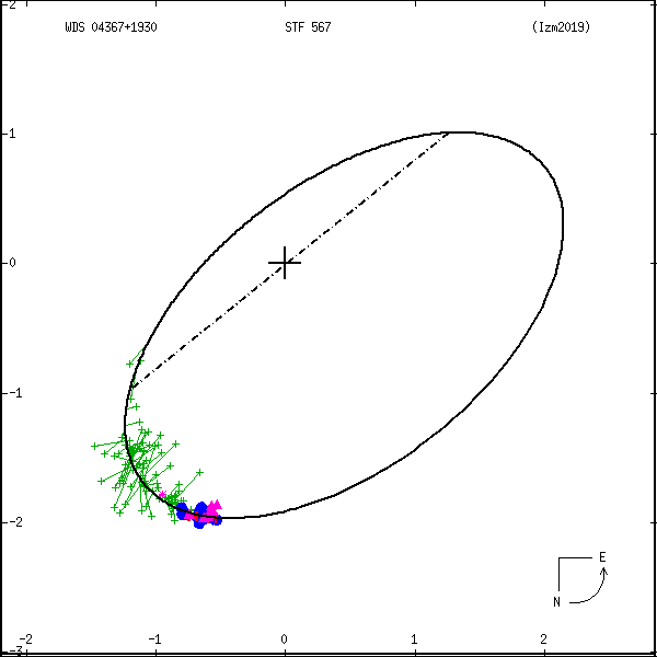
Measures: green=micrometric, blue=interferometric, purple=photographic |
|
WDS 04367+1930 STF 567 (HD 29205) : NOTES
No records found.
REFERENCES
| refcode |
metd |
author |
reference |
| Izm2019 |
orb u |
Izmailov, I.S. |
2019AstL...45...30I |
| Izm2019 |
|
Ast. Lett. 45, 30, 2019 |
|
| Izm2019 |
|
(Orbital elements from weighted solutions used when available (Table 2), |
|
| Izm2019 |
|
unweighted elements (Table 1) used for remaining 29 systems.) |
|
DISCOVERER
| idgroup |
discov |
author |
| 1 |
STF |
Struve, F.G.W. |
WDS HISTORIC DATA
| coord_2000 |
discov_num |
comp |
epoch |
obs |
pa |
sep |
mag_pri |
mag_sec |
spectr |
notes |
coord_arcsec_2000 |
| 04367+1930 |
STF 567 |
|
2006 |
99 |
342 |
2.0 |
9.00 |
9.28 |
G0 |
O |
043642.58+192934.8 |
| 04367+1930 |
STF 567 |
|
2007 |
102 |
343 |
2.0 |
9.00 |
9.28 |
G0 |
O |
043642.58+192934.8 |
| 04367+1930 |
STF 567 |
|
2009 |
104 |
343 |
2.0 |
9.00 |
9.28 |
G0 |
O |
043642.58+192934.8 |
| 04367+1930 |
STF 567 |
|
2012 |
107 |
344 |
1.9 |
9.00 |
9.28 |
G0 |
O |
043642.58+192934.8 |
| 04367+1930 |
STF 567 |
|
2015 |
106 |
344 |
2.1 |
9.00 |
9.28 |
G0 |
O |
043642.58+192934.8 |
| 04367+1930 |
STF 567 |
|
2018 |
109 |
345 |
2.0 |
9.00 |
9.28 |
G0 |
O |
043642.58+192934.8 |
| 04367+1930 |
STF 567 |
|
2019 |
110 |
345 |
2.0 |
9.00 |
9.28 |
G0 |
O |
043642.58+192934.8 |
If you need more information about this double, apply for a
data request form to the WDS.
WDS 04367+1930 STF 567 (HD 29205) : VISUAL OBSERVATIONS REPORTS
No records found.
WDS 04367+1930 STF 567 (HD 29205) : MEASURES
No records found.
WDS 04367+1930 (HD 29205) : VIRTUAL EYEPIECE

Click on the map to see the double of your interest.
Pass over with the mouse cursor to display the catalog designation.
|
|
WDS 04367+1930 (HD 29205) : ALADIN DSS IMAGE @ 04h 36m 42.58s +19° 29' 34.8"
WDS 04367+1930 STF 567 (HD 29205) : NEIGHBORHOODS
|
|

Click on the map to see the double of your interest.
Pass over with the mouse cursor to display the catalog designation.
|
| Show |
name |
coord_2000 |
discov# |
comp |
pa |
sep |
dist(') |
| Show |
|
04367+1930 |
STF 567 |
|
344 |
2.0 |
|
| Show |
|
04366+1930 |
LDS3597 |
|
|
56.3 |
2 |
| Show |
|
04366+1946 |
STT 86 |
|
354 |
0.5 |
17 |
| Show |
|
04376+1915 |
GWP 601 |
|
283 |
20.4 |
20 |
| Show |
|
04381+1942 |
LDS2258 |
|
294 |
3.2 |
23 |
| Show |
|
04357+1953 |
L 4 |
|
134 |
0.1 |
28 |
| Show |
|
04357+1958 |
LDS2256 |
|
329 |
44.6 |
33 |
| Show |
|
04384+1900 |
BRT2317 |
|
183 |
3.8 |
39 |
| Show |
|
04374+1852 |
LDS3600 |
|
185 |
4.4 |
40 |
| Show |
|
04371+1848 |
LDS3599 |
|
175 |
2.0 |
43 |
| Show |
|
04366+1845 |
RUC 4 |
|
39 |
0.8 |
45 |
| Show |
|
04380+2011 |
LDS3601 |
|
17 |
17.1 |
45 |
| Show |
|
04399+1940 |
RED 8 |
|
131 |
0.1 |
46 |
| Show |
|
04334+1949 |
A 2351 |
AB |
173 |
1.0 |
51 |
| Show |
|
04334+1949 |
A 2351 |
AC |
173 |
3.1 |
51 |
| Show |
|
04334+1949 |
GII 130 |
Aa,Ab |
130 |
0.1 |
51 |
| Show |
|
04330+1946 |
KPP 634 |
|
114 |
5.8 |
56 |
| Show |
|
04382+2023 |
KOH 18 |
|
349 |
0.4 |
58 |
| Show |
|
04372+1833 |
OCC 926 |
|
-1 |
0.1 |
58 |
| Show |
|
04407+1905 |
COU 367 |
|
49 |
4.1 |
62 |
| Show |
|
04366+2033 |
LDS3596 |
|
310 |
2.1 |
64 |
| Show |
|
04327+1855 |
DAE 26 |
|
106 |
8.6 |
67 |
| Show |
|
04324+1957 |
LDS2251 |
|
119 |
124.8 |
67 |
| Show |
|
04411+1906 |
LDS2264 |
|
69 |
37.7 |
67 |
| Show |
|
04409+2004 |
LDS2263 |
|
276 |
15.4 |
68 |
| Show |
|
04343+1830 |
SAR 6 |
Aa,Ab |
48 |
0.1 |
69 |
| Show |
|
04343+1830 |
SAR 6 |
Aa,B |
149 |
23.0 |
69 |
| Show |
|
04343+1830 |
SAR 6 |
Aa,C |
214 |
24.5 |
69 |
| Show |
|
04343+1830 |
SAR 6 |
AD |
301 |
9.8 |
69 |
| Show |
|
04343+2030 |
BRT2315 |
|
341 |
4.7 |
70 |
| Show |
|
04352+1822 |
SAR 7 |
AB |
323 |
22.7 |
72 |
| Show |
|
04352+1822 |
SAR 7 |
AC |
258 |
26.1 |
72 |
| Show |
|
04383+1822 |
LDS2259 |
|
285 |
23.9 |
72 |
| Show |
|
04357+1817 |
BRT2316 |
|
288 |
5.0 |
74 |
| Show |
|
04371+2043 |
UC 67 |
|
262 |
24.8 |
74 |
| Show |
|
04313+1931 |
LDS5570 |
|
180 |
17.9 |
77 |
| Show |
|
04337+1824 |
DAE 27 |
|
254 |
7.7 |
78 |
| Show |
|
04414+2014 |
A 2352 |
|
317 |
3.8 |
82 |
| Show |
|
04320+1839 |
KPP1611 |
|
309 |
12.3 |
84 |
| Show |
|
04335+1818 |
LDS2255 |
|
248 |
37.6 |
85 |
| Show |
|
04396+2045 |
HU 441 |
|
47 |
1.7 |
86 |
| Show |
|
04313+2008 |
RAO 51 |
AB |
309 |
19.0 |
86 |
| Show |
|
04313+2008 |
RAO 51 |
BC |
177 |
0.9 |
87 |
| Show |
|
04324+1828 |
BRC 1 |
AC |
30 |
4.3 |
88 |
| Show |
|
04312+1849 |
YSC 179 |
|
150 |
1.8 |
89 |
| Show |
|
04323+1820 |
LDS2252 |
|
52 |
57.7 |
93 |
| Show |
|
04303+1950 |
PAT 10 |
|
303 |
0.2 |
93 |
| Show |
|
04369+2103 |
HU 305 |
AB |
269 |
1.8 |
94 |
| Show |
|
04369+2103 |
FOX9004 |
AC |
81 |
54.0 |
94 |
| Show |
|
04365+1754 |
OCC9097 |
|
-1 |
0.0 |
94 |
| Show |
|
04322+1820 |
KSA 107 |
AB |
14 |
0.1 |
94 |
|
|
WDS 04367+1930 : COMPONENTS
04367+1930 A
| Componente originario normalizzato |
AB |
|
Name |
HD 29205 |
|
Coord arcsec 2000 |
043642.58+192934.8 |
|
Mag |
9 |
|
| Spectral class |
G0 (yellow) |
|
PmRA |
35.00 |
|
PmDE |
-39.0 |
|
SAO |
94032 |
|
| Tycho2 |
1274-01424-1 |
|
HD |
29205 |
|
DM |
BD+19 745 |
|
| Tycho2 |
1274-01424-1 |
|
Pflag |
P |
|
RAmdeg |
69.17740047 |
|
DEmdeg |
19.49300561 |
|
| PmRA |
34.5 |
|
PmDE |
-38.9 |
|
E RAmdeg |
12 |
|
E DEmdeg |
16 |
|
| E pmRA |
1.5 |
|
E pmDE |
1.5 |
|
EpRAm |
1990.81 |
|
EpDEm |
1989.90 |
|
| Num |
6 |
|
Q RAmdeg |
0.8 |
|
Q DEmdeg |
1.0 |
|
Q pmRA |
0.8 |
|
| Q pmDE |
1.0 |
|
BTmag |
9.764 |
|
E BTmag |
0.029 |
|
VTmag |
9.002 |
|
| E VTmag |
0.020 |
|
Prox |
21 |
|
TYC |
T |
|
HIP |
|
|
| CCDM |
|
|
RAdeg |
69.17739250 |
|
DEdeg |
19.49290056 |
|
EpRA 1990 |
1.74 |
|
| EpDE 1990 |
1.51 |
|
E RAdeg |
12.4 |
|
E DEdeg |
16.2 |
|
Posflg |
D |
|
| Corr |
-0.1 |
|
| SAO |
94032 |
|
DelFlag |
|
|
RA1950 |
|
|
PmRA1950 |
0.0022 |
|
| DE1950 |
|
|
PmDE1950 |
-0.033 |
|
Vmag |
8.2 |
|
SpType |
G0 |
|
| Double code |
|
|
Source |
28 |
|
CatNum |
1238 |
|
DM |
BD+19 745 |
|
| DMcomp |
|
|
BDsup |
|
|
HD |
29205 |
|
M HD |
0 |
|
| GC |
|
|
RA1950rad |
1.19458549 |
|
DE1950rad |
0.33846807 |
|
PmRA2000 |
0.0022 |
|
| PmDE2000 |
-0.034 |
|
| Ccdm |
04367+1930 |
|
RComp |
|
|
Comp |
A |
|
Note1 |
|
|
| Note2 |
|
|
Discov num |
|
|
DRAs |
0.61 |
|
DDEs |
-25.6 |
|
| R dRAs |
10 |
|
Year |
|
|
Theta |
|
|
Rho |
|
|
| Obs |
2 |
|
Vmag |
8.9 |
|
Sp |
G0 |
|
PmNote |
* |
|
| PmRA |
44 |
|
PmDE |
-47 |
|
Dm number |
+19 745 |
|
Cat1 |
BD |
|
| Name2 |
+19 363 |
|
Cat2 |
AGK2/3 |
|
HD |
29205 |
|
M HD |
|
|
| ADS BDS |
A 3330 |
|
M ADS BDS |
|
|
N IDS |
|
|
IDS |
04308N1917A |
|
| HIC |
|
|
04367+1930 B
| Componente originario normalizzato |
AB |
|
Coord arcsec 2000 |
043642.54+192936.7 |
|
Mag |
9.28 |
|
PmRA |
35.00 |
|
| PmDE |
-39.0 |
|
Tycho2 |
1274-01424-2 |
|
Calc delta mag |
0.28 |
|
Calc coord |
yes |
|
| Tycho2 |
1274-01424-2 |
|
Pflag |
P |
|
RAmdeg |
69.17740047 |
|
DEmdeg |
19.49300561 |
|
| PmRA |
34.5 |
|
PmDE |
-38.9 |
|
E RAmdeg |
12 |
|
E DEmdeg |
16 |
|
| E pmRA |
1.5 |
|
E pmDE |
1.5 |
|
EpRAm |
1990.81 |
|
EpDEm |
1989.90 |
|
| Num |
6 |
|
Q RAmdeg |
0.8 |
|
Q DEmdeg |
1.0 |
|
Q pmRA |
0.8 |
|
| Q pmDE |
1.0 |
|
BTmag |
10.112 |
|
E BTmag |
0.037 |
|
VTmag |
9.278 |
|
| E VTmag |
0.026 |
|
Prox |
21 |
|
TYC |
T |
|
HIP |
|
|
| CCDM |
|
|
RAdeg |
69.17718222 |
|
DEdeg |
19.49344333 |
|
EpRA 1990 |
1.74 |
|
| EpDE 1990 |
1.51 |
|
E RAdeg |
16.6 |
|
E DEdeg |
21.6 |
|
Posflg |
D |
|
| Corr |
0.0 |
|
| Ccdm |
04367+1930 |
|
RComp |
|
|
Comp |
B |
|
Note1 |
|
|
| Note2 |
|
|
Discov num |
STF 567 |
|
DRAs |
|
|
DDEs |
|
|
| R dRAs |
|
|
Year |
1958 |
|
Theta |
334 |
|
Rho |
2.0 |
|
| Obs |
99 |
|
Vmag |
9.4 |
|
Sp |
|
|
PmNote |
|
|
| PmRA |
|
|
PmDE |
|
|
Dm number |
|
|
Cat1 |
|
|
| Name2 |
|
|
Cat2 |
|
|
HD |
|
|
M HD |
|
|
| ADS BDS |
A 3330 |
|
M ADS BDS |
|
|
N IDS |
|
|
IDS |
04308N1917B |
|
| HIC |
|
|