03332+2817 HO 14 (HD 21945)
03h 33m 14.30s +28° 16' 30.9" P.A. 26.00 sep 2.2 mag 9.70,10.04 Sp A
| Coord 2000 |
03332+2817 |
|
Discov num |
HO 14 |
|
Comp |
|
|
Coord arcsec 2000 |
03 33 14.30 +28 16 30.9 |
|
| Date first |
1883 |
|
Date last |
2018 |
|
Obs |
25 |
|
| Pa first |
21 |
|
Pa last |
25.8 |
|
P.A. Now (θ) |
25.8° |
|
| Sep first |
1.8 |
|
Sep last |
2.164 |
|
Sep. Now (ρ) |
2.164" |
|
| Mag pri |
9.70 |
|
Mag sec |
10.04 |
|
delta mag (ΔM) |
0.34 |
|
Spectral class |
A (white) |
|
| Pri motion ra |
-002 |
|
Sec motion ra |
|
|
| Pri motion dec |
-037 |
|
Sec motion dec |
|
|
| Notes |
|
|
Nature of this double is uncertain.
OTHER CATALOGS AND DESIGNATIONS
| Name |
HD 21945 |
|
Constellation |
Taurus |
|
Tycho2 |
1810-00792-1 |
|
Gaia DR2 |
119471941338354688 |
|
| HD |
21945 |
|
WDS 03332+2817 HO 14 (HD 21945) : NOTES
No records found.
REFERENCES
| refcode |
metd |
author |
reference |
| Ho_1883 |
Ma j |
Hough, G.W. |
1883MNRAS..43..371H |
| Ho_1883 |
|
MNRAS 43, 371, 1883 (data also in Ho_1890) |
1890AN....125....1H |
| Ho_1884 |
Ma j |
Hough, G.W. |
1884MNRAS..44..365H |
| Ho_1884 |
|
MNRAS 44, 365, 1884 (data also in Ho_1890) |
1890AN....125....1H |
| Ho_1885 |
Ma j |
Hough, G.W. |
1885MNRAS..45..417H |
| Ho_1885 |
|
MNRAS 45, 417, 1885 (data also in Ho_1890) |
1890AN....125....1H |
| Ho_1886 |
Ma j |
Hough, G.W. |
1886MNRAS..46..393H |
| Ho_1886 |
|
MNRAS 46, 393, 1886 (data also in Ho_1890) |
1890AN....125....1H |
| Ho_1887 |
Ma j |
Hough, G.W. |
1887AN....116..273H |
| Ho_1887 |
|
AN 116, 273, 1887 |
|
| Ho_1890 |
Ma j |
Hough, G.W. |
1890AN....125....1H |
| Ho_1890 |
|
AN 125, 1, 1890 |
|
| Ho_1890b |
Ma j |
Hough, G.W. |
1890AJ......9..177H |
| Ho_1890b |
|
AJ 9, 177, 1890 (some data also in Ho_1890 or Ho_1894b) |
1890AN....125....1H |
| Ho_1894a |
Ma - |
Hough, G.W. |
1894MNRAS..54..251H |
| Ho_1894a |
|
MNRAS 54, 251, 1894 |
|
| Ho_1894b |
Ma j |
Hough, G.W. (HO 304 - 490) |
1894AN....135..281H |
| Ho_1894b |
|
AN 135, 281, 1894 |
|
| Ho_1894c |
Ma - |
Hough, G.W. (measure by Dembowski, H.) |
1894AN....135..281H |
| Ho_1894c |
|
AN 135, 281, 1894 |
|
| Ho_1899a |
Ma j |
Hough, G.W. |
1899AN....149..65H |
| Ho_1899a |
|
AN 149, 65, 1899 |
|
| Ho_1899b |
Ma - |
Hough, G.W. (measure by Burnham, S.W.) |
1899AN....149..65H |
| Ho_1899b |
|
AN 149, 65, 1899 |
|
| Ho_1907 |
Ma - |
Hough, G.W. |
1907PFAO....3c...1D |
| Ho_1907 |
|
Pub. Univ. Penn. 3, Pt. 3, 1907 (measures sent to Doolittle) |
|
| Ho_1932A |
Ma - |
Hough, G.W. |
1932QB821.A43...... |
| Ho_1932A |
|
cited in ADS, 1932 (unpublished measures sent to Aitken in manuscript by Fox) |
|
WDS HISTORIC DATA
| coord_2000 |
discov_num |
comp |
epoch |
obs |
pa |
sep |
mag_pri |
mag_sec |
spectr |
notes |
coord_arcsec_2000 |
| 03332+2817 |
HO 14 |
|
1999 |
20 |
25 |
2.2 |
9.70 |
10.04 |
A |
|
033314.30+281630.9 |
| 03332+2817 |
HO 14 |
|
2009 |
21 |
26 |
2.0 |
9.70 |
10.04 |
A |
|
033314.30+281630.9 |
| 03332+2817 |
HO 14 |
|
2015 |
23 |
26 |
2.2 |
9.70 |
10.04 |
A |
|
033314.30+281630.9 |
| 03332+2817 |
HO 14 |
|
2018 |
24 |
26 |
2.2 |
9.70 |
10.04 |
A |
|
033314.30+281630.9 |
If you need more information about this double, apply for a
data request form to the WDS.
WDS 03332+2817 HO 14 (HD 21945) : VISUAL OBSERVATIONS REPORTS
No records found.
WDS 03332+2817 HO 14 (HD 21945) : MEASURES
No records found.
WDS 03332+2817 (HD 21945) : VIRTUAL EYEPIECE
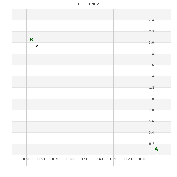
Click on the map to see the double of your interest.
Pass over with the mouse cursor to display the catalog designation.
|
|
WDS 03332+2817 (HD 21945) : ALADIN DSS IMAGE @ 03h 33m 14.30s +28° 16' 30.9"
WDS 03332+2817 HO 14 (HD 21945) : NEIGHBORHOODS
|
|
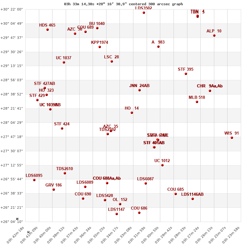
Click on the map to see the double of your interest.
Pass over with the mouse cursor to display the catalog designation.
|
| Show |
name |
coord_2000 |
discov# |
comp |
pa |
sep |
dist(') |
| Show |
|
03332+2817 |
HO 14 |
|
26 |
2.2 |
|
| Show |
|
03326+2844 |
JNN 24 |
AB |
282 |
0.1 |
29 |
| Show |
|
03326+2844 |
JNN 24 |
AC |
104 |
0.3 |
29 |
| Show |
|
03350+2755 |
AZC 35 |
|
122 |
12.2 |
33 |
| Show |
|
03353+2751 |
TDS2592 |
|
96 |
2.1 |
38 |
| Show |
|
03311+2744 |
STFA 7 |
AB |
234 |
44.1 |
44 |
| Show |
|
03311+2744 |
SMR 60 |
BC |
|
12.3 |
45 |
| Show |
|
03313+2734 |
STF 401 |
AB |
270 |
11.5 |
50 |
| Show |
|
03313+2734 |
SHY 445 |
BC |
129 |
999.9 |
50 |
| Show |
|
03350+2919 |
LSC 28 |
|
126 |
0.2 |
67 |
| Show |
|
03306+2713 |
UC 1012 |
|
354 |
48.0 |
73 |
| Show |
|
03277+2829 |
MLB 518 |
|
255 |
3.4 |
75 |
| Show |
|
03286+2904 |
STF 395 |
|
90 |
1.8 |
77 |
| Show |
|
03392+2757 |
STF 424 |
|
313 |
10.0 |
81 |
| Show |
|
03310+2937 |
A 983 |
|
145 |
0.5 |
86 |
| Show |
|
03321+2651 |
LDS6087 |
|
267 |
68.0 |
88 |
| Show |
|
03360+2936 |
KPP1974 |
|
21 |
15.6 |
88 |
| Show |
|
03353+2651 |
COU 688 |
Aa,Ab |
201 |
0.5 |
90 |
| Show |
|
03353+2651 |
STF 415 |
AB |
53 |
15.1 |
90 |
| Show |
|
03353+2651 |
STF 415 |
AC |
357 |
40.0 |
90 |
| Show |
|
03266+2843 |
CHR 9 |
Aa,Ab |
235 |
0.4 |
92 |
| Show |
|
03266+2843 |
TOK 13 |
AB |
129 |
95.6 |
92 |
| Show |
|
03266+2843 |
CIA 10 |
Aa1,2 |
245 |
0.0 |
92 |
| Show |
|
03402+2820 |
UC 1039 |
AB |
3 |
11.7 |
92 |
| Show |
|
03402+2820 |
UC 1039 |
AC |
46 |
48.6 |
92 |
| Show |
|
03402+2820 |
UC 1039 |
BC |
58 |
40.9 |
92 |
| Show |
|
03390+2917 |
UC 1037 |
|
231 |
34.4 |
98 |
| Show |
|
03405+2838 |
HO 323 |
|
208 |
16.5 |
99 |
| Show |
|
03406+2846 |
STF 427 |
AB |
207 |
7.0 |
103 |
| Show |
|
03372+2646 |
LDS6089 |
|
170 |
60.5 |
105 |
| Show |
|
03389+2703 |
TDS2610 |
|
348 |
1.5 |
106 |
| Show |
|
03413+2832 |
STF 429 |
|
105 |
16.8 |
108 |
| Show |
|
03362+2959 |
BU 1040 |
|
338 |
3.2 |
110 |
| Show |
|
03295+2638 |
COU 685 |
|
248 |
2.6 |
111 |
| Show |
|
03355+2630 |
LDS5428 |
|
196 |
36.4 |
111 |
| Show |
|
03372+2954 |
COU 689 |
|
177 |
0.2 |
111 |
| Show |
|
03343+2625 |
OL 152 |
|
50 |
2.3 |
112 |
| Show |
|
03380+2953 |
AZC 36 |
|
58 |
21.8 |
116 |
| Show |
|
03247+2746 |
WIS 91 |
|
327 |
665.6 |
117 |
| Show |
|
03374+2632 |
COU 690 |
|
172 |
4.2 |
118 |
| Show |
|
03325+2615 |
COU 686 |
|
338 |
1.5 |
122 |
| Show |
|
03321+3018 |
LDS3502 |
|
109 |
13.5 |
122 |
| Show |
|
03346+2613 |
LDS1147 |
|
176 |
3.6 |
125 |
| Show |
|
03280+2631 |
LDS1146 |
AB |
308 |
6.0 |
126 |
| Show |
|
03280+2631 |
WIS 93 |
AC |
105 |
636.2 |
126 |
| Show |
|
03398+2643 |
GRV 186 |
|
284 |
31.7 |
129 |
| Show |
|
03262+2950 |
ALP 10 |
|
269 |
24.8 |
132 |
| Show |
|
03416+2655 |
LDS6095 |
|
36 |
40.5 |
138 |
| Show |
|
03277+3013 |
TBN 5 |
|
149 |
0.3 |
138 |
| Show |
|
03404+2957 |
HDS 465 |
|
34 |
0.0 |
138 |
| Show |
|
03276+3014 |
TBN 4 |
|
-1 |
0.3 |
139 |
|
|
WDS 03332+2817 : COMPONENTS
03332+2817 A
| Componente originario normalizzato |
AB |
|
Name |
HD 21945 |
|
Coord arcsec 2000 |
033314.30+281630.9 |
|
Mag |
9.7 |
|
| Spectral class |
A (white) |
|
PmRA |
-2.00 |
|
PmDE |
-37.0 |
|
Tycho2 |
1810-00792-1 |
|
| HD |
21945 |
|
| Tycho2 |
1810-00792-1 |
|
Pflag |
|
|
RAmdeg |
53.30956535 |
|
DEmdeg |
28.27525927 |
|
| PmRA |
-1.7 |
|
PmDE |
-37.1 |
|
E RAmdeg |
14 |
|
E DEmdeg |
17 |
|
| E pmRA |
1.9 |
|
E pmDE |
1.9 |
|
EpRAm |
1989.88 |
|
EpDEm |
1988.68 |
|
| Num |
5 |
|
Q RAmdeg |
4.4 |
|
Q DEmdeg |
7.0 |
|
Q pmRA |
4.3 |
|
| Q pmDE |
6.8 |
|
BTmag |
10.040 |
|
E BTmag |
0.030 |
|
VTmag |
9.703 |
|
| E VTmag |
0.029 |
|
Prox |
22 |
|
TYC |
T |
|
HIP |
|
|
| CCDM |
|
|
RAdeg |
53.30956111 |
|
DEdeg |
28.27532833 |
|
EpRA 1990 |
1.76 |
|
| EpDE 1990 |
1.53 |
|
E RAdeg |
15.0 |
|
E DEdeg |
19.4 |
|
Posflg |
D |
|
| Corr |
-0.1 |
|
| Ccdm |
03332+2817 |
|
RComp |
|
|
Comp |
A |
|
Note1 |
|
|
| Note2 |
|
|
Discov num |
|
|
DRAs |
2.27 |
|
DDEs |
-29.1 |
|
| R dRAs |
10 |
|
Year |
|
|
Theta |
|
|
Rho |
|
|
| Obs |
2 |
|
Vmag |
9.9 |
|
Sp |
A |
|
PmNote |
* |
|
| PmRA |
-2 |
|
PmDE |
-32 |
|
Dm number |
+27 521 |
|
Cat1 |
BD |
|
| Name2 |
+28 365 |
|
Cat2 |
AGK2/3 |
|
HD |
21945 |
|
M HD |
|
|
| ADS BDS |
A 2604 |
|
M ADS BDS |
|
|
N IDS |
|
|
IDS |
03272N2756A |
|
| HIC |
|
|
03332+2817 B
| Componente originario normalizzato |
AB |
|
Coord arcsec 2000 |
033314.36+281632.8 |
|
Mag |
10.04 |
|
Calc delta mag |
0.34 |
|
| Calc coord |
yes |
|
| Ccdm |
03332+2817 |
|
RComp |
|
|
Comp |
B |
|
Note1 |
|
|
| Note2 |
|
|
Discov num |
HO 14 |
|
DRAs |
|
|
DDEs |
|
|
| R dRAs |
|
|
Year |
1883 |
|
Theta |
024 |
|
Rho |
2.0 |
|
| Obs |
17 |
|
Vmag |
10.4 |
|
Sp |
|
|
PmNote |
|
|
| PmRA |
|
|
PmDE |
|
|
Dm number |
|
|
Cat1 |
|
|
| Name2 |
|
|
Cat2 |
|
|
HD |
|
|
M HD |
|
|
| ADS BDS |
A 2604 |
|
M ADS BDS |
|
|
N IDS |
|
|
IDS |
03272N2756B |
|
| HIC |
|
|