23029-1719 RST 3317 (HD 217744)
23h 02m 56.78s -17° 19' 16.8" P.A. 130.00 sep 5.8 mag 9.56,12.10 Sp F6V
| Coord 2000 |
23029-1719 |
|
Discov num |
RST3317 |
|
Comp |
|
|
Coord arcsec 2000 |
23 02 56.78 -17 19 16.8 |
|
| Date first |
1933 |
|
Date last |
2016 |
|
Obs |
8 |
|
| Pa first |
129 |
|
Pa last |
129.8 |
|
P.A. Now (θ) |
129.8° |
|
| Sep first |
5.6 |
|
Sep last |
5.836 |
|
Sep. Now (ρ) |
5.836" |
|
| Mag pri |
9.56 |
|
Mag sec |
12.10 |
|
delta mag (ΔM) |
2.54 |
|
Spectral class |
F6V (yellow-white) |
|
| Pri motion ra |
+027 |
|
Sec motion ra |
+004 |
|
| Pri motion dec |
-014 |
|
Sec motion dec |
-069 |
|
| Notes |
|
|
rPM=0.863
This double is not physical.
OTHER CATALOGS AND DESIGNATIONS
| Name |
HD 217744 |
|
Constellation |
Aquarius |
|
SAO |
165462 |
|
Tycho2 |
6394-00153-1 |
|
| Gaia DR2 |
2400402933348653056 |
|
HD |
217744 |
|
WDS 23029-1719 RST 3317 (HD 217744) : NOTES
No records found.
REFERENCES
| refcode |
metd |
author |
reference |
| Rst1933 |
T - |
Rossiter, R.A. |
1933MmRAS..65...27R |
| Rst1933 |
|
MemRAS 65, 27, 1933 |
|
| Rst1937 |
Ma - |
Rossiter, R.A. |
1937MmRAS..65...51R |
| Rst1937 |
|
MemRAS 65, 51, 1937 |
|
| Rst1943 |
Ma - |
Rossiter, R.A. |
1943POMic...8..133R |
| Rst1943 |
|
Pub. Univ. Michigan Obs. 8, 133, 1943 |
|
| Rst1944 |
- |
Rossiter, R.A. |
1944POMic...9....1R |
| Rst1944 |
|
Pub. Univ. Michigan Obs. 9, 1, 1944 |
|
| Rst1947 |
Ma - |
Rossiter, R.A. |
1947POMic...9....7R |
| Rst1947 |
|
Pub. Univ. Michigan Obs. 9, 7, 1947 |
|
| Rst1955 |
Ma j |
Rossiter, R.A. |
1955POMic..11....1R |
| Rst1955 |
+P+ |
Pub. Univ. Michigan Obs. 11, 1, 1955 |
|
| Rst1964 |
Ma - |
Rossiter, R.A. |
1964POMic...9...73R |
| Rst1964 |
|
Pub. Univ. Michigan Obs. 9, 73, 1964 |
|
WDS HISTORIC DATA
| coord_2000 |
discov_num |
comp |
epoch |
obs |
pa |
sep |
mag_pri |
mag_sec |
spectr |
notes |
coord_arcsec_2000 |
| 23029-1719 |
RST3317 |
|
1999 |
4 |
129 |
5.8 |
9.56 |
12.10 |
F6V |
D |
230256.78-171916.8 |
| 23029-1719 |
RST3317 |
|
2010 |
6 |
131 |
4.7 |
9.56 |
12.10 |
F6V |
|
230256.78-171916.8 |
| 23029-1719 |
RST3317 |
|
2015 |
6 |
130 |
5.8 |
9.56 |
12.10 |
F6V |
|
230256.78-171916.8 |
| 23029-1719 |
RST3317 |
|
2016 |
8 |
130 |
5.8 |
9.56 |
12.10 |
F6V |
|
230256.78-171916.8 |
If you need more information about this double, apply for a
data request form to the WDS.
WDS 23029-1719 RST 3317 (HD 217744) : VISUAL OBSERVATIONS REPORTS
No records found.
WDS 23029-1719 RST 3317 (HD 217744) : MEASURES
No records found.
WDS 23029-1719 (HD 217744) : VIRTUAL EYEPIECE
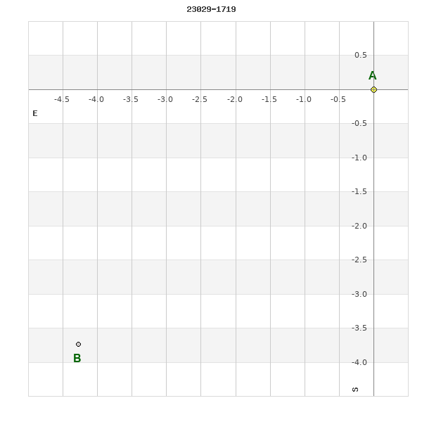
Click on the map to see the double of your interest.
Pass over with the mouse cursor to display the catalog designation.
|
|
WDS 23029-1719 (HD 217744) : ALADIN DSS IMAGE @ 23h 02m 56.78s -17° 19' 16.8"
WDS 23029-1719 RST 3317 (HD 217744) : NEIGHBORHOODS
|
|
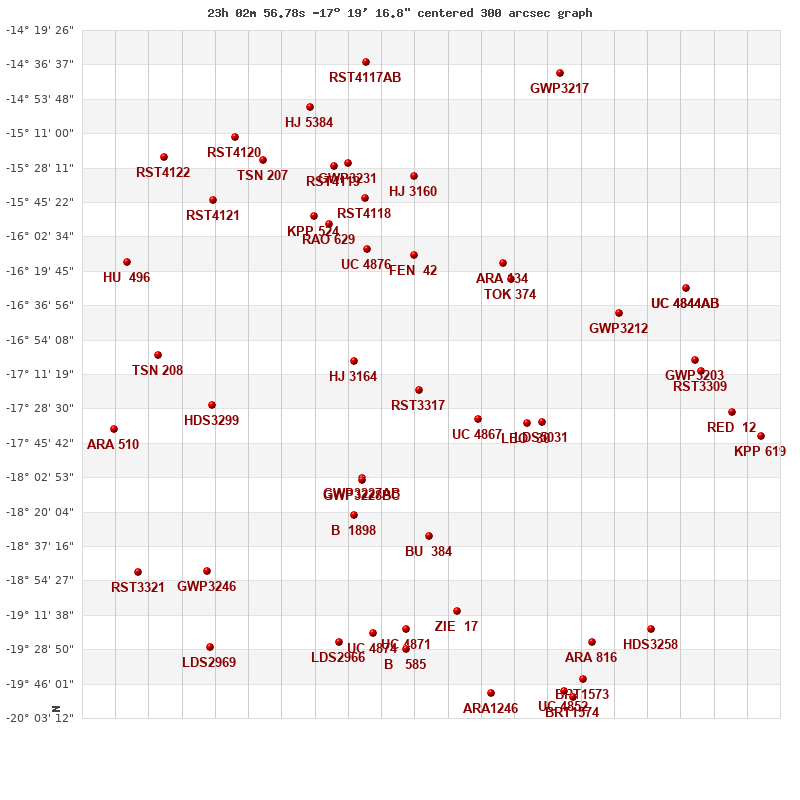
Click on the map to see the double of your interest.
Pass over with the mouse cursor to display the catalog designation.
|
| Show |
name |
coord_2000 |
discov# |
comp |
pa |
sep |
dist(') |
| Show |
|
23029-1719 |
RST3317 |
|
130 |
5.8 |
1 |
| Show |
|
23009-1734 |
UC 4867 |
|
120 |
8.8 |
33 |
| Show |
|
23052-1705 |
HJ 3164 |
|
122 |
56.3 |
36 |
| Show |
|
23049-1803 |
GWP3227 |
AB |
199 |
56.3 |
53 |
| Show |
|
23049-1803 |
GWP3228 |
BC |
38 |
6.3 |
53 |
| Show |
|
22592-1736 |
LEO 30 |
|
157 |
1.5 |
56 |
| Show |
|
22587-1735 |
LDS5031 |
|
32 |
20.8 |
63 |
| Show |
|
23032-1612 |
FEN 42 |
|
278 |
4.2 |
68 |
| Show |
|
23052-1822 |
B 1898 |
|
231 |
0.2 |
71 |
| Show |
|
22598-1624 |
TOK 374 |
|
287 |
0.2 |
72 |
| Show |
|
23026-1832 |
BU 384 |
|
59 |
1.1 |
74 |
| Show |
|
23047-1609 |
UC 4876 |
|
265 |
32.8 |
75 |
| Show |
|
23001-1616 |
ARA 134 |
|
163 |
8.9 |
76 |
| Show |
|
23060-1556 |
RAO 629 |
|
25 |
0.8 |
95 |
| Show |
|
23048-1543 |
RST4118 |
|
192 |
2.4 |
100 |
| Show |
|
23066-1552 |
KPP 524 |
|
317 |
4.6 |
102 |
| Show |
|
23101-1727 |
HDS3299 |
|
307 |
1.0 |
103 |
| Show |
|
22561-1641 |
GWP3212 |
|
72 |
28.3 |
107 |
| Show |
|
23032-1533 |
HJ 3160 |
|
47 |
10.7 |
108 |
| Show |
|
23017-1910 |
ZIE 17 |
|
29 |
4.5 |
112 |
| Show |
|
23054-1526 |
GWP3231 |
|
23 |
29.5 |
119 |
| Show |
|
23034-1919 |
UC 4871 |
|
336 |
18.1 |
120 |
| Show |
|
23059-1527 |
RST4119 |
|
210 |
1.9 |
120 |
| Show |
|
23045-1921 |
UC 4874 |
|
327 |
29.2 |
124 |
| Show |
|
23034-1929 |
B 585 |
|
338 |
1.9 |
130 |
| Show |
|
23120-1702 |
TSN 208 |
|
38 |
0.5 |
131 |
| Show |
|
23058-1926 |
LDS2966 |
|
226 |
3.4 |
133 |
| Show |
|
22535-1704 |
GWP3203 |
|
183 |
21.3 |
137 |
| Show |
|
23103-1850 |
GWP3246 |
|
359 |
98.0 |
139 |
| Show |
|
23083-1525 |
TSN 207 |
|
103 |
0.0 |
139 |
| Show |
|
22533-1710 |
RST3309 |
|
316 |
1.0 |
140 |
| Show |
|
23101-1545 |
RST4121 |
|
17 |
1.2 |
140 |
| Show |
|
22538-1628 |
UC 4844 |
AB |
92 |
27.3 |
142 |
| Show |
|
22538-1628 |
GWP3205 |
AC |
294 |
18.3 |
142 |
| Show |
|
23067-1452 |
HJ 5384 |
|
195 |
29.8 |
152 |
| Show |
|
22570-1925 |
ARA 816 |
|
214 |
5.5 |
152 |
| Show |
|
23135-1738 |
ARA 510 |
|
237 |
10.4 |
153 |
| Show |
|
22522-1730 |
RED 12 |
|
358 |
0.1 |
155 |
| Show |
|
23004-1951 |
ARA1246 |
|
187 |
6.4 |
156 |
| Show |
|
23093-1513 |
RST4120 |
|
267 |
1.4 |
156 |
| Show |
|
23130-1616 |
HU 496 |
|
118 |
1.4 |
159 |
| Show |
|
23102-1926 |
LDS2969 |
|
148 |
3.1 |
165 |
| Show |
|
22549-1919 |
HDS3258 |
|
159 |
0.2 |
166 |
| Show |
|
22574-1944 |
BRT1573 |
|
301 |
4.1 |
166 |
| Show |
|
23127-1850 |
RST3321 |
|
65 |
1.9 |
166 |
| Show |
|
23048-1436 |
RST4117 |
AB |
275 |
0.9 |
166 |
| Show |
|
22579-1950 |
UC 4852 |
|
106 |
54.0 |
167 |
| Show |
|
22512-1742 |
KPP 619 |
|
225 |
5.7 |
171 |
| Show |
|
22577-1953 |
BRT1574 |
|
359 |
4.1 |
171 |
| Show |
|
23118-1523 |
RST4122 |
|
271 |
0.2 |
172 |
| Show |
|
22581-1441 |
GWP3217 |
|
167 |
25.6 |
174 |
|
|
WDS 23029-1719 : COMPONENTS
23029-1719 A
| Componente originario normalizzato |
AB |
|
Name |
HD 217744 |
|
Coord arcsec 2000 |
230256.78-171916.8 |
|
Mag |
9.56 |
|
| Spectral class |
F6V (yellow-white) |
|
PmRA |
27.00 |
|
PmDE |
-14.0 |
|
SAO |
165462 |
|
| Tycho2 |
6394-00153-1 |
|
HD |
217744 |
|
DM |
BD-18 6243 |
|
| Tycho2 |
6394-00153-1 |
|
Pflag |
|
|
RAmdeg |
345.73660078 |
|
DEmdeg |
-17.32134835 |
|
| PmRA |
37.8 |
|
PmDE |
-20.8 |
|
E RAmdeg |
12 |
|
E DEmdeg |
16 |
|
| E pmRA |
1.4 |
|
E pmDE |
1.4 |
|
EpRAm |
1989.40 |
|
EpDEm |
1987.86 |
|
| Num |
9 |
|
Q RAmdeg |
1.0 |
|
Q DEmdeg |
1.2 |
|
Q pmRA |
1.0 |
|
| Q pmDE |
1.3 |
|
BTmag |
10.052 |
|
E BTmag |
0.028 |
|
VTmag |
9.557 |
|
| E VTmag |
0.024 |
|
Prox |
999 |
|
TYC |
T |
|
HIP |
|
|
| CCDM |
|
|
RAdeg |
345.73650889 |
|
DEdeg |
-17.32129833 |
|
EpRA 1990 |
1.78 |
|
| EpDE 1990 |
1.68 |
|
E RAdeg |
13.1 |
|
E DEdeg |
16.6 |
|
Posflg |
|
|
| Corr |
-0.1 |
|
| SAO |
165462 |
|
DelFlag |
|
|
RA1950 |
|
|
PmRA1950 |
0.0015 |
|
| DE1950 |
|
|
PmDE1950 |
0.019 |
|
Vmag |
9 |
|
SpType |
G0 |
|
| Double code |
|
|
Source |
22 |
|
CatNum |
9698 |
|
DM |
BD-18 6243 |
|
| DMcomp |
|
|
BDsup |
|
|
HD |
217744 |
|
M HD |
0 |
|
| GC |
|
|
RA1950rad |
6.02266125 |
|
DE1950rad |
-0.30700704 |
|
PmRA2000 |
0.0017 |
|
| PmDE2000 |
0.015 |
|
| Ccdm |
23029-1719 |
|
RComp |
|
|
Comp |
A |
|
Note1 |
|
|
| Note2 |
|
|
Discov num |
|
|
DRAs |
2.63 |
|
DDEs |
-13.8 |
|
| R dRAs |
10 |
|
Year |
|
|
Theta |
|
|
Rho |
|
|
| Obs |
2 |
|
Vmag |
9.2 |
|
Sp |
G0 |
|
PmNote |
* |
|
| PmRA |
21 |
|
PmDE |
19 |
|
Dm number |
-18 6243 |
|
Cat1 |
BD |
|
| Name2 |
165462 |
|
Cat2 |
SAO |
|
HD |
217744 |
|
M HD |
|
|
| ADS BDS |
|
|
M ADS BDS |
|
|
N IDS |
|
|
IDS |
22576S1752A |
|
| HIC |
|
|
23029-1719 B
| Componente originario normalizzato |
AB |
|
Coord arcsec 2000 |
230257.08-171920.5 |
|
Mag |
12.1 |
|
PmRA |
4.00 |
|
| PmDE |
-69.0 |
|
Calc delta mag |
2.54 |
|
Calc coord |
yes |
|
| Ccdm |
23029-1719 |
|
RComp |
|
|
Comp |
B |
|
Note1 |
|
|
| Note2 |
|
|
Discov num |
RST3317 |
|
DRAs |
|
|
DDEs |
|
|
| R dRAs |
|
|
Year |
1933 |
|
Theta |
129 |
|
Rho |
5.6 |
|
| Obs |
3 |
|
Vmag |
11.7 |
|
Sp |
|
|
PmNote |
|
|
| PmRA |
|
|
PmDE |
|
|
Dm number |
|
|
Cat1 |
|
|
| Name2 |
|
|
Cat2 |
|
|
HD |
|
|
M HD |
|
|
| ADS BDS |
|
|
M ADS BDS |
|
|
N IDS |
|
|
IDS |
22576S1752B |
|
| HIC |
|
|