22522-1730 RED 12
22h 52m 10.73s -17° 30' 13.4" P.A. 358.00 sep 0.1 mag 15.43,16.55 Sp L6+T3.5
| Coord 2000 |
22522-1730 |
|
Discov num |
RED 12 |
|
Comp |
|
|
Coord arcsec 2000 |
22 52 10.73 -17 30 13.4 |
|
| Date first |
2005 |
|
Date last |
2013 |
|
Obs |
13 |
|
| Pa first |
354 |
|
Pa last |
358.2 |
|
P.A. Now (θ) |
354.5° |
|
| Sep first |
0.1 |
|
Sep last |
0.142 |
|
Sep. Now (ρ) |
0.132" |
|
| Mag pri |
15.43 |
|
Mag sec |
16.55 |
|
delta mag (ΔM) |
1.12 |
|
Spectral class |
L6+T3.5 (very deep red/brown dwarf) |
|
| Pri motion ra |
+405 |
|
Sec motion ra |
|
|
| Pri motion dec |
+154 |
|
Sec motion dec |
|
|
| Notes |
N
O
K
(See Notes, Orbital solution, K-band or other infrared magnitudes) |
|
Visually invisible, K-band or other infrared star : Summary line gives K-band or other infrared (>1 micron) magnitudes
This double is physical.
OTHER CATALOGS AND DESIGNATIONS
ORBITAL ELEMENTS
| Period (P) | 8.832y | ± 0.027 |
Periastron (T) | 60727d (2025.141y) | ± 23 |
Semi-major axis (a) | 123.2m | ± 0.8 |
| Eccentricity (e) | 0.335 | ± 0.009 |
Inclination (i) | 108.8° | ± 0.5 |
Longitude of periastron (ω) | 314.6° | ± 1.2 |
| Node (Ω) | 178° | ± 0.3 |
Notes | n | |
Reference | Dup2017 | |
| Equinox | | |
Last observation | 2013 | |
Grade | 3 | (1=Definitive, 9=Indet.) |
| label |
theta |
rho |
| 2000 |
158.3 |
0.079 |
| 2001 |
103.2 |
0.046 |
| 2002 |
37.9 |
0.074 |
| 2003 |
16.9 |
0.119 |
| 2004 |
6.4 |
0.146 |
| 2005 |
357.8 |
0.143 |
| 2006 |
345.0 |
0.096 |
| 2007 |
253.3 |
0.029 |
| 2008 |
178.7 |
0.088 |
| 2009 |
152.9 |
0.073 |
| 2010 |
88.3 |
0.046 |
| 2011 |
32.7 |
0.082 |
| 2012 |
14.8 |
0.125 |
| 2013 |
5.0 |
0.148 |
| 2014 |
356.2 |
0.138 |
| 2015 |
341.1 |
0.084 |
| 2016 |
222.4 |
0.037 |
| 2017 |
174.7 |
0.091 |
| 2018 |
146.4 |
0.066 |
| 2019 |
74.2 |
0.049 |
| 2020 |
28.4 |
0.090 |
| 2021 |
12.9 |
0.131 |
| 2022 |
3.6 |
0.149 |
| 2023 |
354.5 |
0.132 |
| 2024 |
335.7 |
0.070 |
| 2025 |
204.9 |
0.050 |
| 2026 |
170.9 |
0.091 |
| 2027 |
138.4 |
0.060 |
| 2028 |
61.9 |
0.053 |
| 2029 |
24.8 |
0.098 |
| 2030 |
11.1 |
0.136 |
|
|
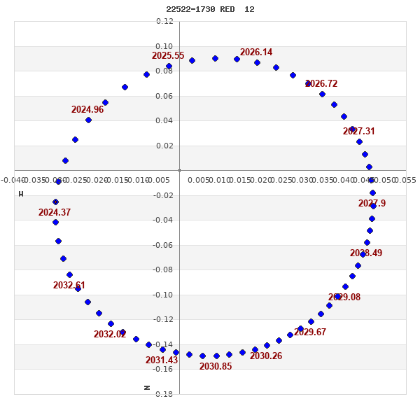
Note: Theta is PA, Rho is Sep. For yearly orbits, data refer to Jan 1st.
|
|
|
|
|
|
|
|
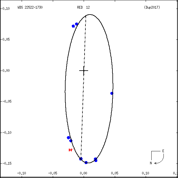
Measures: green=micrometric, blue=interferometric, purple=photographic |
|
WDS 22522-1730 RED 12 : NOTES
| discov_num |
notes |
refcode |
| RED 12 |
2MASS J22521073-1730134 |
|
|
A component spectral type probably L6 +/- 1, B component T2/T3; masses |
|
|
are about 0.07 and 0.06 Msun. Estimated distance is 13.6 pc. |
Red2006a |
REFERENCES
| refcode |
metd |
author |
reference |
| Dup2017 |
A j |
Dupuy, T.J. & Liu, M.C. |
2017ApJS..231...15D |
| Dup2017 |
+orb |
ApJS 231, 15, 2017 |
|
| Red2006a |
Hn j |
Reid, I.N., Lewitus, E., Burgasser, A.J., & Cruz, K.L. |
2006ApJ...639.1114R |
| Red2006a |
|
ApJ 639, 1114, 2006 |
|
WDS HISTORIC DATA
| coord_2000 |
discov_num |
comp |
epoch |
obs |
pa |
sep |
mag_pri |
mag_sec |
spectr |
notes |
coord_arcsec_2000 |
| 22522-1730 |
RED 12 |
|
2005 |
1 |
350 |
0.1 |
15.43 |
16.55 |
L6+T2 |
N DK |
225210.73-173013.4 |
| 22522-1730 |
RED 12 |
|
2013 |
11 |
358 |
0.1 |
15.43 |
16.55 |
L6+T3.5 |
N K |
225210.73-173013.4 |
If you need more information about this double, apply for a
data request form to the WDS.
WDS 22522-1730 RED 12 : VISUAL OBSERVATIONS REPORTS
No records found.
WDS 22522-1730 RED 12 : MEASURES
No records found.
WDS 22522-1730 : VIRTUAL EYEPIECE

Click on the map to see the double of your interest.
Pass over with the mouse cursor to display the catalog designation.
|
|
WDS 22522-1730 : ALADIN DSS IMAGE @ 22h 52m 10.73s -17° 30' 13.4"
WDS 22522-1730 RED 12 : NEIGHBORHOODS
|
|
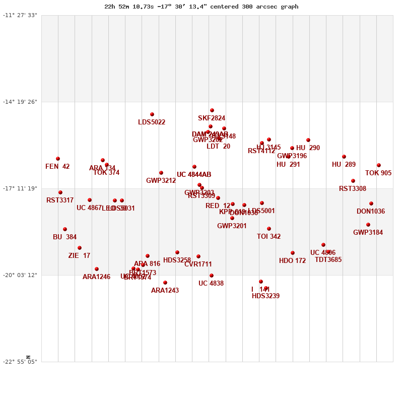
Click on the map to see the double of your interest.
Pass over with the mouse cursor to display the catalog designation.
|
| Show |
name |
coord_2000 |
discov# |
comp |
pa |
sep |
dist(') |
| Show |
|
22522-1730 |
RED 12 |
|
358 |
0.1 |
1 |
| Show |
|
22512-1742 |
KPP 619 |
|
225 |
5.7 |
19 |
| Show |
|
22533-1710 |
RST3309 |
|
316 |
1.0 |
26 |
| Show |
|
22504-1744 |
DON1038 |
|
67 |
0.4 |
30 |
| Show |
|
22535-1704 |
GWP3203 |
|
183 |
21.3 |
32 |
| Show |
|
22512-1811 |
GWP3201 |
|
82 |
20.3 |
43 |
| Show |
|
22492-1740 |
LDS5001 |
|
25 |
4.2 |
45 |
| Show |
|
22538-1628 |
UC 4844 |
AB |
92 |
27.3 |
66 |
| Show |
|
22538-1628 |
GWP3205 |
AC |
294 |
18.3 |
66 |
| Show |
|
22561-1641 |
GWP3212 |
|
72 |
28.3 |
75 |
| Show |
|
22487-5935 |
TOI 342 |
|
227 |
0.4 |
79 |
| Show |
|
22587-1735 |
LDS5031 |
|
32 |
20.8 |
94 |
| Show |
|
22592-1736 |
LEO 30 |
|
157 |
1.5 |
101 |
| Show |
|
22473-1609 |
HU 291 |
|
326 |
2.7 |
108 |
| Show |
|
22549-1919 |
HDS3258 |
|
159 |
0.2 |
116 |
| Show |
|
22492-1541 |
RST4112 |
|
112 |
0.6 |
118 |
| Show |
|
22521-1533 |
LDT 20 |
|
252 |
0.7 |
118 |
| Show |
|
22535-1926 |
CVR1711 |
|
357 |
4.2 |
118 |
| Show |
|
22471-1552 |
GWP3196 |
|
134 |
12.3 |
123 |
| Show |
|
23009-1734 |
UC 4867 |
|
120 |
8.8 |
126 |
| Show |
|
22487-1534 |
HJ 3145 |
|
196 |
15.2 |
127 |
| Show |
|
22598-1624 |
TOK 374 |
|
287 |
0.2 |
128 |
| Show |
|
22528-1519 |
GWP3202 |
|
182 |
128.8 |
132 |
| Show |
|
22470-1919 |
HDO 172 |
|
83 |
22.1 |
132 |
| Show |
|
22570-1925 |
ARA 816 |
|
214 |
5.5 |
135 |
| Show |
|
23001-1616 |
ARA 134 |
|
163 |
8.9 |
136 |
| Show |
|
22429-1656 |
RST3308 |
|
137 |
0.9 |
137 |
| Show |
|
22527-1513 |
HJ 3148 |
|
140 |
29.7 |
138 |
| Show |
|
22449-1903 |
UC 4806 |
|
57 |
29.0 |
139 |
| Show |
|
22527-1509 |
DAM 249 |
AB |
8 |
12.9 |
142 |
| Show |
|
22527-1509 |
DAM 249 |
AC |
244 |
14.6 |
142 |
| Show |
|
22460-1536 |
HU 290 |
|
353 |
17.5 |
146 |
| Show |
|
22435-1608 |
HU 289 |
|
280 |
1.3 |
149 |
| Show |
|
22417-1742 |
DON1036 |
|
282 |
0.6 |
151 |
| Show |
|
22574-1944 |
BRT1573 |
|
301 |
4.1 |
152 |
| Show |
|
22446-1918 |
TDT3685 |
|
224 |
7.2 |
152 |
| Show |
|
22526-2004 |
UC 4838 |
|
90 |
50.4 |
155 |
| Show |
|
23029-1719 |
RST3317 |
|
130 |
5.8 |
155 |
| Show |
|
22419-1823 |
GWP3184 |
|
23 |
45.7 |
157 |
| Show |
|
23026-1832 |
BU 384 |
|
59 |
1.1 |
162 |
| Show |
|
22579-1950 |
UC 4852 |
|
106 |
54.0 |
162 |
| Show |
|
22577-1953 |
BRT1574 |
|
359 |
4.1 |
163 |
| Show |
|
23017-1910 |
ZIE 17 |
|
29 |
4.5 |
168 |
| Show |
|
22412-1625 |
TOK 905 |
|
65 |
4.5 |
171 |
| Show |
|
22492-2016 |
I 141 |
|
322 |
3.0 |
171 |
| Show |
|
22526-1437 |
SKF2824 |
|
251 |
6.5 |
174 |
| Show |
|
22558-2018 |
ARA1243 |
|
271 |
10.1 |
176 |
| Show |
|
23032-1612 |
FEN 42 |
|
278 |
4.2 |
176 |
| Show |
|
22567-1444 |
LDS5022 |
|
251 |
2.3 |
179 |
| Show |
|
23004-1951 |
ARA1246 |
|
187 |
6.4 |
184 |
| Show |
|
22489-2029 |
HDS3239 |
|
199 |
0.3 |
185 |
|
|
WDS 22522-1730 : COMPONENTS
22522-1730 A
| Componente originario normalizzato |
AB |
|
Coord arcsec 2000 |
225210.73-173013.4 |
|
Mag |
15.43 |
|
Spectral class |
L6 (very deep red) |
|
| PmRA |
405.00 |
|
PmDE |
154.0 |
|
22522-1730 B
| Componente originario normalizzato |
AB |
|
Coord arcsec 2000 |
225210.73-173013.3 |
|
Mag |
16.55 |
|
Spectral class |
T3.5 (brown dwarf) |
|
| Calc delta mag |
1.12 |
|
Calc coord |
yes |
|