20482+3326 ES 2377
20h 48m 11.54s +33° 26' 18.7" P.A. 220.00 sep 4.3 mag 10.80,11.00
| Coord 2000 |
20482+3326 |
|
Discov num |
ES 2377 |
|
Comp |
|
|
Coord arcsec 2000 |
20 48 11.54 +33 26 18.7 |
|
| Date first |
1929 |
|
Date last |
2015 |
|
Obs |
5 |
|
| Pa first |
207 |
|
Pa last |
220.3 |
|
P.A. Now (θ) |
220.3° |
|
| Sep first |
3.5 |
|
Sep last |
4.324 |
|
Sep. Now (ρ) |
4.324" |
|
| Mag pri |
10.80 |
|
Mag sec |
11.00 |
|
delta mag (ΔM) |
0.2 |
|
Spectral class |
|
|
| Pri motion ra |
+044 |
|
Sec motion ra |
-019 |
|
| Pri motion dec |
+049 |
|
Sec motion dec |
-012 |
|
| Notes |
N
(See Notes) |
|
rPM=1.332
This double is not physical.
OTHER CATALOGS AND DESIGNATIONS
| Constellation |
Cygnus |
|
Gaia DR2 |
1869074045300509824 |
|
WDS 20482+3326 ES 2377 : NOTES
| discov_num |
notes |
refcode |
| ES 2377 |
ES 2377a. See note for 20487+3334ES 9006. |
|
DISCOVERER
| discov |
author |
| ES |
Espin, T.E. |
WDS HISTORIC DATA
| coord_2000 |
discov_num |
comp |
epoch |
obs |
pa |
sep |
mag_pri |
mag_sec |
spectr |
dm_number |
notes |
coord_arcsec_2000 |
| 20482+3326 |
ES 2377 |
|
2002 |
3 |
217 |
4.1 |
10.80 |
11.00 |
|
|
N D |
204811.54+332618.7 |
| 20482+3326 |
ES 2377 |
|
2015 |
5 |
220 |
4.3 |
10.80 |
11.00 |
|
|
N |
204811.54+332618.7 |
If you need more information about this double, apply for a
data request form to the WDS.
WDS 20482+3326 ES 2377 : VISUAL OBSERVATIONS REPORTS
No records found.
WDS 20482+3326 ES 2377 : MEASURES
No records found.
WDS 20482+3326 : VIRTUAL EYEPIECE
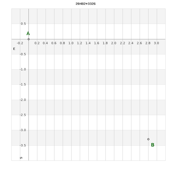
Click on the map to see the double of your interest.
Pass over with the mouse cursor to display the catalog designation.
|
|
WDS 20482+3326 : ALADIN DSS IMAGE @ 20h 48m 11.54s +33° 26' 18.7"
WDS 20482+3326 ES 2377 : NEIGHBORHOODS
|
|

Click on the map to see the double of your interest.
Pass over with the mouse cursor to display the catalog designation.
|
| Show |
name |
coord_2000 |
discov# |
comp |
pa |
sep |
dist(') |
| Show |
|
20482+3326 |
ES 2377 |
|
220 |
4.3 |
0 |
| Show |
|
20487+3334 |
ES 9006 |
|
93 |
25.3 |
10 |
| Show |
|
20470+3318 |
TDT2535 |
|
86 |
0.7 |
17 |
| Show |
|
20477+3343 |
NSN 736 |
|
354 |
45.5 |
18 |
| Show |
|
20493+3314 |
ES 31 |
AB |
238 |
13.8 |
19 |
| Show |
|
20493+3314 |
ES 31 |
AC |
143 |
18.7 |
19 |
| Show |
|
20503+3337 |
ES 2378 |
|
193 |
6.2 |
28 |
| Show |
|
20477+3258 |
COU1634 |
|
61 |
0.4 |
29 |
| Show |
|
20460+3308 |
GYL 69 |
|
357 |
26.7 |
34 |
| Show |
|
20469+3252 |
ARG 93 |
|
87 |
10.9 |
38 |
| Show |
|
20481+3403 |
LDS1047 |
|
7 |
110.2 |
39 |
| Show |
|
20483+3247 |
TDT2550 |
|
132 |
0.9 |
40 |
| Show |
Aljanah |
20462+3358 |
CHR 100 |
Aa,Ab |
350 |
0.0 |
41 |
| Show |
Aljanah |
20462+3358 |
STT 594 |
AB |
261 |
79.2 |
41 |
| Show |
Aljanah |
20462+3358 |
BU 676 |
AC |
269 |
79.0 |
41 |
| Show |
Aljanah |
20462+3358 |
LEP 96 |
AD |
271 |
93.4 |
41 |
| Show |
|
20519+3327 |
GYL 26 |
AB |
353 |
28.6 |
47 |
| Show |
|
20519+3327 |
WSI 47 |
AC |
337 |
11.0 |
47 |
| Show |
|
20520+3320 |
TDT2590 |
|
116 |
0.5 |
48 |
| Show |
|
20504+3406 |
GRV 387 |
|
254 |
26.4 |
49 |
| Show |
|
20447+3357 |
ES 2311 |
|
44 |
7.0 |
53 |
| Show |
|
20448+3401 |
GRV 376 |
|
179 |
65.2 |
55 |
| Show |
|
20437+3332 |
GRV 373 |
|
178 |
26.2 |
56 |
| Show |
|
20446+3401 |
TDT2511 |
|
36 |
3.2 |
57 |
| Show |
|
20528+3320 |
LDS2932 |
|
107 |
9.1 |
58 |
| Show |
|
20472+3422 |
BU 677 |
AB |
120 |
10.0 |
58 |
| Show |
|
20472+3422 |
BU 677 |
AC |
211 |
16.8 |
58 |
| Show |
|
20491+3230 |
GYL 70 |
|
188 |
61.2 |
58 |
| Show |
|
20486+3424 |
ES 249 |
|
26 |
7.7 |
59 |
| Show |
|
20521+3254 |
TDT2591 |
|
5 |
0.5 |
60 |
| Show |
|
20452+3240 |
TDT2517 |
|
144 |
1.6 |
60 |
| Show |
|
20488+3426 |
SEI1256 |
|
279 |
26.3 |
61 |
| Show |
|
20522+3401 |
TDT2593 |
|
257 |
4.5 |
61 |
| Show |
|
20435+3302 |
GRV 372 |
|
109 |
17.3 |
63 |
| Show |
|
20442+3404 |
TDT2507 |
|
165 |
0.9 |
63 |
| Show |
|
20445+3409 |
HU 690 |
|
278 |
0.5 |
63 |
| Show |
|
20533+3319 |
LDS2933 |
|
146 |
9.0 |
65 |
| Show |
|
20432+3350 |
HDS2949 |
|
165 |
0.9 |
67 |
| Show |
|
20493+3430 |
POP 51 |
|
347 |
6.6 |
67 |
| Show |
|
20532+3349 |
TDT2605 |
|
301 |
0.8 |
67 |
| Show |
|
20532+3301 |
ES 2356 |
|
250 |
5.0 |
68 |
| Show |
|
20525+3246 |
GYL 39 |
|
83 |
14.9 |
68 |
| Show |
|
20493+3217 |
LDS2931 |
AB |
246 |
34.4 |
71 |
| Show |
|
20493+3217 |
HLA 28 |
AC |
125 |
5.3 |
71 |
| Show |
|
20437+3243 |
COU1633 |
Aa,Ab |
239 |
1.9 |
71 |
| Show |
|
20437+3243 |
ES 2376 |
AB |
124 |
7.6 |
71 |
| Show |
|
20539+3320 |
TDT2612 |
|
202 |
0.5 |
72 |
| Show |
|
20539+3326 |
BLL 52 |
|
59 |
186.6 |
72 |
| Show |
|
20424+3405 |
ES 2309 |
|
168 |
4.1 |
75 |
| Show |
|
20471+3210 |
ARY 61 |
|
237 |
99.4 |
78 |
| Show |
|
20431+3411 |
ES 2310 |
|
33 |
4.1 |
78 |
|
|
WDS 20482+3326 : COMPONENTS
20482+3326 A
| Coord arcsec 2000 |
204811.54+332618.7 |
|
Mag |
10.8 |
|
PmRA |
44.00 |
|
PmDE |
49.0 |
|
20482+3326 B
| Coord arcsec 2000 |
204811.32+332615.4 |
|
Mag |
11 |
|
PmRA |
-19.00 |
|
PmDE |
-12.0 |
|
| Delta magnitude |
0.2 |
|
Coordinate calculated |
yes |
|