02134-1644 TDS 2164
02h 13m 24.80s -16° 43' 33.1" P.A. 90.00 sep 0.8 mag 11.78,12.12
| Coord 2000 |
02134-1644 |
|
Discov num |
TDS2164 |
|
Comp |
|
|
Coord arcsec 2000 |
02 13 24.80 -16 43 33.1 |
|
| Date first |
1991 |
|
Date last |
1991 |
|
Obs |
1 |
|
| Pa first |
90 |
|
Pa last |
90 |
|
P.A. Now (θ) |
90° |
|
| Sep first |
0.8 |
|
Sep last |
0.84 |
|
Sep. Now (ρ) |
0.84" |
|
| Mag pri |
11.78 |
|
Mag sec |
12.12 |
|
delta mag (ΔM) |
0.34 |
|
Spectral class |
|
|
| Pri motion ra |
+014 |
|
Sec motion ra |
+014 |
|
| Pri motion dec |
+009 |
|
Sec motion dec |
+009 |
|
| Notes |
X
(Dubious double) |
|
Nature of this double is uncertain.
OTHER CATALOGS AND DESIGNATIONS
| Constellation |
Cetus |
|
Tycho2 |
5859-01087-1 |
|
Gaia DR2 |
5144446788459638784 |
|
WDS 02134-1644 TDS 2164 : NOTES
No records found.
DISCOVERER
| discov |
author |
| TDS |
Tycho Double Star (from additional DD list) |
WDS HISTORIC DATA
| coord_2000 |
discov_num |
comp |
epoch |
obs |
pa |
sep |
mag_pri |
mag_sec |
spectr |
dm_number |
notes |
coord_arcsec_2000 |
| 02134-1644 |
TDS2164 |
|
1991 |
1 |
90 |
0.8 |
11.78 |
12.12 |
|
|
|
021324.80-164333.1 |
If you need more information about this double, apply for a
data request form to the WDS.
WDS 02134-1644 TDS 2164 : VISUAL OBSERVATIONS REPORTS
No records found.
WDS 02134-1644 TDS 2164 : MEASURES
No records found.
WDS 02134-1644 : VIRTUAL EYEPIECE
Click on the map to see the double of your interest.
Pass over with the mouse cursor to display the catalog designation.
|
|
WDS 02134-1644 : ALADIN DSS IMAGE @ 02h 13m 24.80s -16° 43' 33.1"
WDS 02134-1644 TDS 2164 : NEIGHBORHOODS
|
|
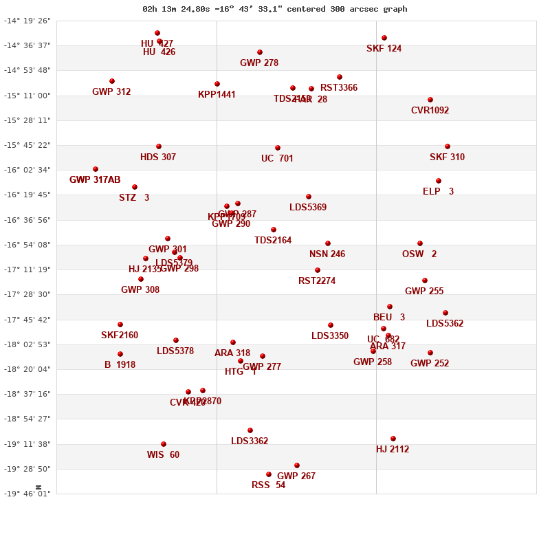
Click on the map to see the double of your interest.
Pass over with the mouse cursor to display the catalog designation.
|
| Show |
name |
coord_2000 |
discov# |
comp |
pa |
sep |
dist(') |
| Show |
|
02134-1644 |
TDS2164 |
|
90 |
0.8 |
0 |
| Show |
|
02160-1626 |
GWP 287 |
|
211 |
10.5 |
41 |
| Show |
|
02109-1620 |
LDS5369 |
|
282 |
68.2 |
44 |
| Show |
|
02164-1632 |
GWP 290 |
|
61 |
9.3 |
45 |
| Show |
|
02168-1628 |
KPP1709 |
|
142 |
13.2 |
51 |
| Show |
|
02103-1712 |
RST2274 |
|
322 |
6.5 |
54 |
| Show |
|
02095-1653 |
NSN 246 |
|
94 |
5.0 |
57 |
| Show |
|
02131-1547 |
UC 701 |
|
140 |
17.7 |
57 |
| Show |
|
02142-1811 |
GWP 277 |
|
78 |
6.9 |
89 |
| Show |
|
02163-1802 |
ARA 318 |
|
12 |
15.5 |
89 |
| Show |
|
02092-1750 |
LDS3350 |
|
254 |
55.2 |
89 |
| Show |
|
02158-1814 |
HTG 1 |
|
172 |
2.1 |
97 |
| Show |
|
02201-1703 |
GWP 298 |
|
12 |
100.3 |
98 |
| Show |
|
02120-1506 |
TDS2153 |
|
316 |
0.6 |
100 |
| Show |
|
02204-1658 |
LDS5379 |
|
101 |
48.9 |
103 |
| Show |
|
02107-1507 |
FAR 28 |
|
218 |
2.6 |
105 |
| Show |
|
02210-1650 |
GWP 301 |
|
233 |
5.9 |
110 |
| Show |
|
02174-1503 |
KPP1441 |
|
283 |
10.8 |
116 |
| Show |
|
02144-1441 |
GWP 278 |
|
70 |
11.5 |
123 |
| Show |
|
02087-1458 |
RST3366 |
|
240 |
1.7 |
126 |
| Show |
|
02203-1759 |
LDS5378 |
|
236 |
289.0 |
127 |
| Show |
|
02051-1737 |
BEU 3 |
|
288 |
0.2 |
131 |
| Show |
|
02216-1546 |
HDS 307 |
|
257 |
0.5 |
132 |
| Show |
|
02055-1752 |
UC 682 |
|
355 |
14.1 |
133 |
| Show |
|
02185-1835 |
KPP2870 |
|
222 |
2.9 |
133 |
| Show |
|
02062-1808 |
GWP 258 |
|
52 |
4.3 |
133 |
| Show |
|
02225-1704 |
HJ 2135 |
|
322 |
16.6 |
134 |
| Show |
|
02051-1757 |
ARA 317 |
|
170 |
10.8 |
139 |
| Show |
|
02151-1902 |
LDS3362 |
|
2 |
12.4 |
141 |
| Show |
|
02229-1718 |
GWP 308 |
|
9 |
295.1 |
141 |
| Show |
|
02195-1836 |
CVR 420 |
|
90 |
9.1 |
143 |
| Show |
|
02234-1614 |
STZ 3 |
|
196 |
12.6 |
147 |
| Show |
|
02029-1653 |
OSW 2 |
|
75 |
71.7 |
152 |
| Show |
|
02026-1719 |
GWP 255 |
|
345 |
13.4 |
160 |
| Show |
|
02117-1927 |
GWP 267 |
|
52 |
37.3 |
165 |
| Show |
|
02138-1933 |
RSS 54 |
|
172 |
27.8 |
170 |
| Show |
|
02244-1749 |
SKF2160 |
|
37 |
77.3 |
171 |
| Show |
|
02016-1610 |
ELP 3 |
|
296 |
0.5 |
174 |
| Show |
|
02216-1434 |
HU 426 |
|
349 |
0.8 |
176 |
| Show |
|
02055-1431 |
SKF 124 |
|
300 |
2.7 |
176 |
| Show |
|
02244-1810 |
B 1918 |
|
116 |
5.2 |
180 |
| Show |
|
02217-1428 |
HU 427 |
|
326 |
0.6 |
182 |
| Show |
|
02022-1808 |
GWP 252 |
|
179 |
10.2 |
182 |
| Show |
|
02022-1514 |
CVR1092 |
|
66 |
3.3 |
186 |
| Show |
|
02011-1741 |
LDS5362 |
|
262 |
13.4 |
186 |
| Show |
|
02213-1912 |
WIS 60 |
|
269 |
487.8 |
187 |
| Show |
|
02262-1602 |
GWP 317 |
AB |
246 |
43.2 |
189 |
| Show |
|
02262-1602 |
GWP 317 |
Aa,Ab |
278 |
0.4 |
189 |
| Show |
|
02009-1546 |
SKF 310 |
|
173 |
7.8 |
189 |
| Show |
|
02048-1908 |
HJ 2112 |
|
172 |
17.0 |
190 |
| Show |
|
02250-1501 |
GWP 312 |
|
136 |
8.9 |
196 |
|
|
WDS 02134-1644 : COMPONENTS
02134-1644 A
| Coord arcsec 2000 |
021324.80-164333.1 |
|
Mag |
11.78 |
|
PmRA |
14.00 |
|
PmDE |
9.0 |
|
| Tycho2 |
5859-01087-1 |
|
| Tycho2 |
5859-01087-1 |
|
Pflag |
|
|
RAmdeg |
33.35345531 |
|
DEmdeg |
-16.72584051 |
|
| PmRA |
13.6 |
|
PmDE |
9.1 |
|
E RAmdeg |
43 |
|
E DEmdeg |
55 |
|
| E pmRA |
2.3 |
|
E pmDE |
2.4 |
|
EpRAm |
1986.34 |
|
EpDEm |
1983.66 |
|
| Num |
4 |
|
Q RAmdeg |
2.0 |
|
Q DEmdeg |
1.2 |
|
Q pmRA |
1.9 |
|
| Q pmDE |
1.2 |
|
BTmag |
11.727 |
|
E BTmag |
0.078 |
|
VTmag |
11.319 |
|
| E VTmag |
0.090 |
|
Prox |
999 |
|
TYC |
T |
|
HIP |
|
|
| CCDM |
|
|
RAdeg |
33.35342194 |
|
DEdeg |
-16.72586194 |
|
EpRA 1990 |
1.65 |
|
| EpDE 1990 |
1.46 |
|
E RAdeg |
44.9 |
|
E DEdeg |
57.8 |
|
Posflg |
|
|
| Corr |
-0.1 |
|
02134-1644 B
| Coord arcsec 2000 |
021324.86-164333.1 |
|
Mag |
12.12 |
|
PmRA |
14.00 |
|
PmDE |
9.0 |
|
| Delta magnitude |
0.34 |
|
Coordinate calculated |
yes |
|