17594+2929 COU 1003 Aa,Ab
17h 59m 24.52s +29° 29' 29.6" P.A. 359.00 sep 0.1 mag 9.92,9.92 Sp F5
| Coord 2000 |
17594+2929 |
|
Discov num |
COU1003 |
|
Comp |
Aa,Ab |
|
Coord arcsec 2000 |
17 59 24.52 +29 29 29.6 |
|
| Date first |
1973 |
|
Date last |
2018 |
|
Obs |
8 |
|
| Pa first |
56 |
|
Pa last |
358.8 |
|
P.A. Now (θ) |
358.8° |
|
| Sep first |
0.2 |
|
Sep last |
0.057 |
|
Sep. Now (ρ) |
0.057" |
|
| Mag pri |
9.92 |
|
Mag sec |
9.92 |
|
delta mag (ΔM) |
0 |
|
Spectral class |
F5 (yellow-white) |
|
| Pri motion ra |
-030 |
|
Sec motion ra |
|
|
| Pri motion dec |
-027 |
|
Sec motion dec |
|
|
| Notes |
O
W
(Orbital solution, ) |
|
This double is physical.
17594+2929 SYSTEM COMPONENTS
| Show |
name |
SAO |
coord |
wds_name |
last |
obs |
pa |
sep |
mag1 |
mag2 |
d_mag |
orb |
current |
| Show |
|
|
17 59 25 +29 29 30 |
COU 1003 Aa,Ab |
2018 |
8 |
359 |
0.1 |
9.92 |
9.92 |
0.00 |
Y |
<=== |
| Show |
|
|
17 59 25 +29 29 30 |
STF 2247 AB |
2018 |
36 |
188 |
11.6 |
9.17 |
9.88 |
0.71 |
|
|
| Show |
|
|
17 59 25 +29 29 30 |
WAL 88 AC |
2018 |
9 |
230 |
56.1 |
9.17 |
12.49 |
3.32 |
|
|
Quadruple system
3 estimated visually detectable stars in this system
OTHER CATALOGS AND DESIGNATIONS
| Constellation |
Hercules |
|
Tycho2 |
2102-01493-1 |
|
Gaia DR2 |
4584635116105365120 |
|
ADS |
10961 |
|
ORBITAL ELEMENTS
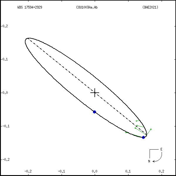
| Period (P) | 159.3y | ± 13.1 |
Periastron (T) | 1971.2y | ± 4 |
Semi-major axis (a) | 0.233a | ± 0.012 |
| Eccentricity (e) | 0.178 | ± 0.023 |
Inclination (i) | 100.4° | ± 0.2 |
Longitude of periastron (ω) | 317° | ± 12.5 |
| Node (Ω) | 51° | ± 0.3 |
Notes | | |
Reference | BAE2021 | |
| Equinox | | |
Last observation | | |
Grade | 4 | (1=Definitive, 9=Indet.) |
| label |
theta |
rho |
| 2000 |
41.7 |
0.167 |
| 2001 |
40.9 |
0.162 |
| 2002 |
40.1 |
0.157 |
| 2003 |
39.2 |
0.152 |
| 2004 |
38.2 |
0.146 |
| 2005 |
37.1 |
0.140 |
| 2006 |
36.0 |
0.134 |
| 2007 |
34.7 |
0.128 |
| 2008 |
33.3 |
0.122 |
| 2009 |
31.7 |
0.115 |
| 2010 |
30.0 |
0.109 |
| 2011 |
28.0 |
0.102 |
| 2012 |
25.8 |
0.096 |
| 2013 |
23.2 |
0.089 |
| 2014 |
20.3 |
0.083 |
| 2015 |
16.9 |
0.077 |
| 2016 |
12.8 |
0.070 |
| 2017 |
8.0 |
0.065 |
| 2018 |
2.4 |
0.060 |
| 2019 |
355.7 |
0.055 |
| 2020 |
347.9 |
0.051 |
| 2021 |
339.0 |
0.048 |
| 2022 |
329.3 |
0.047 |
| 2023 |
319.2 |
0.046 |
| 2024 |
309.2 |
0.048 |
| 2025 |
300.0 |
0.050 |
| 2026 |
291.9 |
0.054 |
| 2027 |
284.8 |
0.058 |
| 2028 |
278.9 |
0.063 |
| 2029 |
273.8 |
0.069 |
| 2030 |
269.6 |
0.075 |
|
|
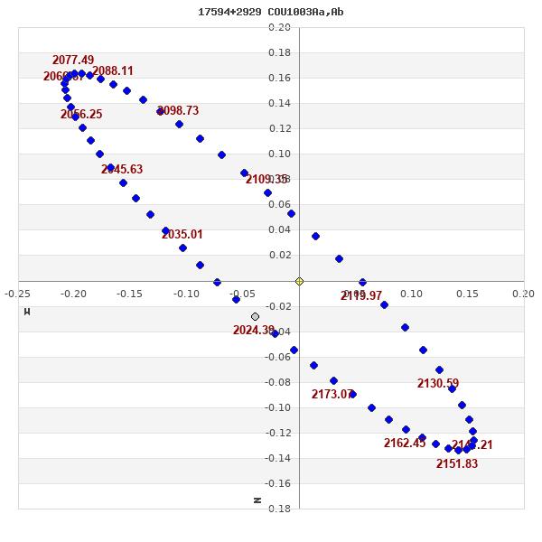
Note: Theta is PA, Rho is Sep. For yearly orbits, data refer to Jan 1st.
|
|
|
|
|
|
|
|
Measures: green=micrometric, blue=interferometric, purple=photographic |
|
WDS 17594+2929 COU 1003 Aa,Ab : NOTES
No records found.
REFERENCES
| refcode |
metd |
author |
reference |
| BAE2021 |
orb j |
Baidin, A.E. & Krechet, V.G. |
2021AstBu..76...84B |
| BAE2021 |
|
Astrophys. Bull. 76, 84, 2021 |
|
DISCOVERER
| idgroup |
discov |
author |
| 1 |
COU |
Couteau, P. |
| 240 |
STF |
Struve, F.G.W. |
| 273 |
WAL |
Wallenquist, A. |
WDS HISTORIC DATA
| coord_2000 |
discov_num |
comp |
epoch |
obs |
pa |
sep |
mag_pri |
mag_sec |
spectr |
notes |
coord_arcsec_2000 |
| 17594+2929 |
COU1003 |
Aa,Ab |
1991 |
6 |
38 |
0.2 |
9.92 |
9.92 |
F5 |
|
175924.52+292929.6 |
| 17594+2929 |
COU1003 |
Aa,Ab |
2018 |
8 |
359 |
0.1 |
9.92 |
9.92 |
F5 |
W |
175924.52+292929.6 |
If you need more information about this double, apply for a
data request form to the WDS.
WDS 17594+2929 COU 1003 Aa,Ab : VISUAL OBSERVATIONS REPORTS
No records found.
WDS 17594+2929 COU 1003 Aa,Ab : MEASURES
No records found.
WDS 17594+2929 : VIRTUAL EYEPIECE

Click on the map to see the double of your interest.
Pass over with the mouse cursor to display the catalog designation.
|
|
WDS 17594+2929 : ALADIN DSS IMAGE @ 17h 59m 24.52s +29° 29' 29.6"
WDS 17594+2929 COU 1003 Aa,Ab : NEIGHBORHOODS
|
|

Click on the map to see the double of your interest.
Pass over with the mouse cursor to display the catalog designation.
|
| Show |
name |
coord_2000 |
discov# |
comp |
pa |
sep |
dist(') |
| Show |
|
17594+2929 |
COU1003 |
Aa,Ab |
359 |
0.1 |
|
| Show |
|
17594+2929 |
STF2247 |
AB |
188 |
11.6 |
|
| Show |
|
17594+2929 |
WAL 88 |
AC |
230 |
56.1 |
|
| Show |
|
18006+2934 |
LDS6413 |
|
105 |
88.1 |
17 |
| Show |
|
17590+3003 |
STF2259 |
|
277 |
19.6 |
34 |
| Show |
|
17567+2929 |
D 17 |
|
130 |
23.9 |
36 |
| Show |
|
18025+2931 |
NSN 701 |
|
266 |
16.5 |
41 |
| Show |
|
18026+2931 |
LDS4771 |
|
251 |
16.6 |
43 |
| Show |
|
17585+3011 |
HDS2534 |
|
355 |
0.5 |
44 |
| Show |
|
18006+3014 |
J 1127 |
|
341 |
2.9 |
47 |
| Show |
|
17559+2943 |
AZC 102 |
|
35 |
21.3 |
48 |
| Show |
|
17564+2846 |
GRV 971 |
|
237 |
73.0 |
59 |
| Show |
|
17564+3018 |
KPP2118 |
|
349 |
17.2 |
63 |
| Show |
|
17564+3028 |
KPP4069 |
AC |
76 |
2.5 |
71 |
| Show |
|
17549+2852 |
CBL 163 |
|
244 |
41.5 |
71 |
| Show |
|
17541+2949 |
AC 9 |
|
242 |
1.0 |
72 |
| Show |
|
17577+2815 |
HO 424 |
|
204 |
1.4 |
78 |
| Show |
|
18039+3023 |
WIS 322 |
|
284 |
999.9 |
79 |
| Show |
|
18041+3025 |
KPP4077 |
|
249 |
16.8 |
83 |
| Show |
|
17566+3045 |
COU 999 |
|
311 |
1.4 |
84 |
| Show |
|
18049+3015 |
TDT 667 |
|
146 |
1.5 |
85 |
| Show |
|
18020+3047 |
COU 811 |
|
153 |
2.2 |
85 |
| Show |
|
17529+2941 |
AC 8 |
|
304 |
0.1 |
86 |
| Show |
|
18032+2813 |
AZC 103 |
|
146 |
14.1 |
92 |
| Show |
|
18060+3002 |
TDT 679 |
|
347 |
0.7 |
92 |
| Show |
|
17575+2759 |
HO 423 |
|
293 |
4.7 |
94 |
| Show |
|
18069+2933 |
SLE 135 |
|
126 |
9.7 |
98 |
| Show |
|
17520+2917 |
AZC 101 |
|
270 |
22.6 |
99 |
| Show |
|
18054+3029 |
SLE 131 |
BC |
217 |
15.0 |
100 |
| Show |
|
18054+3029 |
SLE 131 |
AB |
203 |
52.4 |
100 |
| Show |
|
18054+3029 |
SLE 131 |
AC |
206 |
67.2 |
100 |
| Show |
|
17578+2751 |
ALL 2 |
|
206 |
18.9 |
101 |
| Show |
|
18063+2843 |
HJ 1313 |
|
297 |
13.7 |
103 |
| Show |
|
18015+3113 |
TDT 639 |
|
142 |
0.6 |
107 |
| Show |
|
17566+3110 |
ES 343 |
|
281 |
8.5 |
109 |
| Show |
|
17512+2946 |
BRT 31 |
|
147 |
7.6 |
109 |
| Show |
|
18033+2751 |
ES 470 |
|
208 |
8.3 |
112 |
| Show |
|
18054+3054 |
SLE 130 |
|
103 |
6.7 |
115 |
| Show |
|
18028+3115 |
TDT 651 |
|
228 |
0.6 |
115 |
| Show |
|
18075+2846 |
STA 2 |
|
87 |
0.1 |
116 |
| Show |
|
18083+2941 |
YSC 65 |
Aa,Ac |
246 |
0.1 |
117 |
| Show |
|
18083+2941 |
LAF 60 |
Aa,Ab |
251 |
0.1 |
117 |
| Show |
|
18083+2941 |
LAF 60 |
AB |
53 |
10.4 |
117 |
| Show |
|
18083+2941 |
LAF 60 |
AC |
196 |
11.2 |
117 |
| Show |
|
18083+2941 |
LAF 60 |
AD |
168 |
13.4 |
117 |
| Show |
|
18083+2941 |
LAF 60 |
AE |
262 |
16.3 |
117 |
| Show |
|
17510+3010 |
COU 636 |
|
269 |
1.5 |
118 |
| Show |
|
18019+3123 |
SEI 554 |
|
48 |
23.5 |
118 |
| Show |
|
17558+3117 |
SEI 552 |
|
235 |
5.6 |
118 |
| Show |
|
18070+3034 |
SCA 170 |
Aa,Ab |
230 |
0.2 |
118 |
| Show |
|
18070+3034 |
AC 15 |
AB |
331 |
1.4 |
118 |
|
|
WDS 17594+2929 : COMPONENTS
| |
A |
Ab |
B |
| Ab |
pa=359.0°
sep=0.06"
| |
| B |
pa=187.3°
sep=11.59"
| pa=187.3°
sep=11.65"
| |
| C |
pa=226.5°
sep=51.88"
| pa=226.4°
sep=51.92"
| pa=236.1°
sep=43.51"
|
17594+2929 A
| Coord arcsec 2000 |
175924.52+292929.6 |
|
Mag |
9.17 |
|
Spectral class |
F5 (yellow-white) |
|
PmRA |
-7.00 |
|
| PmDE |
-7.0 |
|
Tycho2 |
2102-01493-1 |
|
ADS |
10961 |
|
DM |
BD+29 3160 |
|
| Tycho2 |
2102-01493-1 |
|
Pflag |
|
|
RAmdeg |
269.85216515 |
|
DEmdeg |
29.49156280 |
|
| PmRA |
-5.2 |
|
PmDE |
-9.8 |
|
E RAmdeg |
11 |
|
E DEmdeg |
10 |
|
| E pmRA |
1.3 |
|
E pmDE |
1.2 |
|
EpRAm |
1990.59 |
|
EpDEm |
1990.61 |
|
| Num |
9 |
|
Q RAmdeg |
2.0 |
|
Q DEmdeg |
1.9 |
|
Q pmRA |
2.1 |
|
| Q pmDE |
1.8 |
|
BTmag |
9.749 |
|
E BTmag |
0.022 |
|
VTmag |
9.168 |
|
| E VTmag |
0.017 |
|
Prox |
115 |
|
TYC |
T |
|
HIP |
|
|
| CCDM |
|
|
RAdeg |
269.85217944 |
|
DEdeg |
29.49158583 |
|
EpRA 1990 |
1.59 |
|
| EpDE 1990 |
1.64 |
|
E RAdeg |
11.1 |
|
E DEdeg |
10.2 |
|
Posflg |
|
|
| Corr |
0.1 |
|
| Ccdm |
17594+2929 |
|
RComp |
|
|
Comp |
A |
|
Note1 |
|
|
| Note2 |
|
|
Discov num |
|
|
DRAs |
0.57 |
|
DDEs |
27.0 |
|
| R dRAs |
12 |
|
Year |
|
|
Theta |
|
|
Rho |
|
|
| Obs |
3 |
|
Vmag |
9.5 |
|
Sp |
F5 |
|
PmNote |
|
|
| PmRA |
38 |
|
PmDE |
-55 |
|
Dm number |
+29 3160 |
|
Cat1 |
BD |
|
| Name2 |
+29 1768 |
|
Cat2 |
AGK2/3 |
|
HD |
|
|
M HD |
|
|
| ADS BDS |
A10961 |
|
M ADS BDS |
|
|
N IDS |
|
|
IDS |
17556N2930A |
|
| HIC |
|
|
17594+2929 Ab
| Coord arcsec 2000 |
175924.52+292929.7 |
|
Mag |
9.92 |
|
Calc coord |
yes |
|
17594+2929 B
| Coord arcsec 2000 |
175924.41+292918.1 |
|
Mag |
9.88 |
|
PmRA |
-7.00 |
|
PmDE |
-7.0 |
|
| Tycho2 |
2102-02774-1 |
|
Calc delta mag |
0.04 |
|
Calc coord |
yes |
|
| Tycho2 |
2102-02774-1 |
|
Pflag |
|
|
RAmdeg |
269.85161916 |
|
DEmdeg |
29.48840395 |
|
| PmRA |
-4.8 |
|
PmDE |
-9.4 |
|
E RAmdeg |
18 |
|
E DEmdeg |
20 |
|
| E pmRA |
1.8 |
|
E pmDE |
1.8 |
|
EpRAm |
1990.53 |
|
EpDEm |
1990.14 |
|
| Num |
4 |
|
Q RAmdeg |
2.7 |
|
Q DEmdeg |
0.6 |
|
Q pmRA |
2.7 |
|
| Q pmDE |
0.6 |
|
BTmag |
10.397 |
|
E BTmag |
0.033 |
|
VTmag |
9.876 |
|
| E VTmag |
0.029 |
|
Prox |
115 |
|
TYC |
T |
|
HIP |
|
|
| CCDM |
|
|
RAdeg |
269.85163194 |
|
DEdeg |
29.48842611 |
|
EpRA 1990 |
1.64 |
|
| EpDE 1990 |
1.55 |
|
E RAdeg |
18.4 |
|
E DEdeg |
20.0 |
|
Posflg |
|
|
| Corr |
0.1 |
|
| Ccdm |
17594+2929 |
|
RComp |
|
|
Comp |
B |
|
Note1 |
|
|
| Note2 |
|
|
Discov num |
COU1003 |
|
DRAs |
|
|
DDEs |
|
|
| R dRAs |
|
|
Year |
1973 |
|
Theta |
56 |
|
Rho |
0.2 |
|
| Obs |
1 |
|
Vmag |
9.2 |
|
Sp |
|
|
PmNote |
|
|
| PmRA |
|
|
PmDE |
|
|
Dm number |
|
|
Cat1 |
|
|
| Name2 |
|
|
Cat2 |
|
|
HD |
|
|
M HD |
|
|
| ADS BDS |
A10961 |
|
M ADS BDS |
|
|
N IDS |
|
|
IDS |
17555N2930P |
|
| HIC |
|
|
17594+2929 C
| Coord arcsec 2000 |
175921.64+292853.9 |
|
Mag |
12.49 |
|
PmRA |
-7.00 |
|
PmDE |
-7.0 |
|
| Calc delta mag |
2.57 |
|
Calc coord |
yes |
|
| Ccdm |
17594+2929 |
|
RComp |
|
|
Comp |
C |
|
Note1 |
|
|
| Note2 |
|
|
Discov num |
STF2247 |
|
DRAs |
|
|
DDEs |
|
|
| R dRAs |
|
|
Year |
1830 |
|
Theta |
190 |
|
Rho |
11.5 |
|
| Obs |
11 |
|
Vmag |
10.0 |
|
Sp |
|
|
PmNote |
|
|
| PmRA |
|
|
PmDE |
|
|
Dm number |
|
|
Cat1 |
|
|
| Name2 |
+29 1767 |
|
Cat2 |
AGK2/3 |
|
HD |
|
|
M HD |
|
|
| ADS BDS |
A10961 |
|
M ADS BDS |
|
|
N IDS |
|
|
IDS |
17556N2930B |
|
| HIC |
|
|