10585-1935 TDS 7583
10h 58m 27.32s -19° 34' 47.9" P.A. 246.00 sep 0.8 mag 11.88,12.20
| Coord 2000 |
10585-1935 |
|
Discov num |
TDS7583 |
|
Comp |
|
|
Coord arcsec 2000 |
10 58 27.32 -19 34 47.9 |
|
| Date first |
1991 |
|
Date last |
1991 |
|
Obs |
1 |
|
| Pa first |
246 |
|
Pa last |
245.9 |
|
P.A. Now (θ) |
245.9° |
|
| Sep first |
0.8 |
|
Sep last |
0.82 |
|
Sep. Now (ρ) |
0.82" |
|
| Mag pri |
11.88 |
|
Mag sec |
12.20 |
|
delta mag (ΔM) |
0.32 |
|
Spectral class |
|
|
| Pri motion ra |
-026 |
|
Sec motion ra |
-026 |
|
| Pri motion dec |
-004 |
|
Sec motion dec |
-004 |
|
| Notes |
X
(Dubious double) |
|
Nature of this double is uncertain.
OTHER CATALOGS AND DESIGNATIONS
| Constellation |
Crater |
|
Tycho2 |
6079-01312-1 |
|
Gaia DR2 |
3552350412387920640 |
|
WDS 10585-1935 TDS 7583 : NOTES
No records found.
DISCOVERER
| discov |
author |
| TDS |
Tycho Double Star (from additional DD list) |
WDS HISTORIC DATA
| coord_2000 |
discov_num |
comp |
epoch |
obs |
pa |
sep |
mag_pri |
mag_sec |
spectr |
dm_number |
notes |
coord_arcsec_2000 |
| 10585-1935 |
TDS7583 |
|
1991 |
1 |
246 |
0.8 |
11.88 |
12.20 |
|
|
|
105827.32-193447.9 |
If you need more information about this double, apply for a
data request form to the WDS.
WDS 10585-1935 TDS 7583 : VISUAL OBSERVATIONS REPORTS
No records found.
WDS 10585-1935 TDS 7583 : MEASURES
No records found.
WDS 10585-1935 : VIRTUAL EYEPIECE

Click on the map to see the double of your interest.
Pass over with the mouse cursor to display the catalog designation.
|
|
WDS 10585-1935 : ALADIN DSS IMAGE @ 10h 58m 27.32s -19° 34' 47.9"
WDS 10585-1935 TDS 7583 : NEIGHBORHOODS
|
|
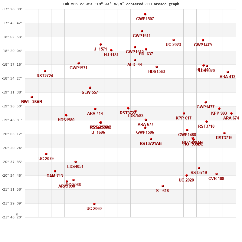
Click on the map to see the double of your interest.
Pass over with the mouse cursor to display the catalog designation.
|
| Show |
name |
coord_2000 |
discov# |
comp |
pa |
sep |
dist(') |
| Show |
|
10585-1935 |
TDS7583 |
|
246 |
0.8 |
0 |
| Show |
|
10591-1931 |
RST3722 |
|
273 |
0.3 |
10 |
| Show |
|
10576-1945 |
ARA 677 |
|
32 |
15.1 |
17 |
| Show |
|
10576-1955 |
GWP1506 |
|
328 |
40.6 |
24 |
| Show |
|
10571-2009 |
RST3721 |
AB |
344 |
0.7 |
40 |
| Show |
|
10571-2009 |
ARA 676 |
AC |
53 |
12.0 |
40 |
| Show |
|
11015-1949 |
RSS 253 |
AB |
356 |
19.0 |
45 |
| Show |
|
11015-1949 |
RSS 253 |
AC |
5 |
17.2 |
45 |
| Show |
|
11015-1949 |
RSS 253 |
BC |
90 |
1.5 |
46 |
| Show |
|
11019-1932 |
ARA 414 |
|
197 |
16.5 |
50 |
| Show |
|
11017-1955 |
B 1696 |
|
4 |
1.9 |
50 |
| Show |
|
10543-1938 |
KPP 617 |
|
275 |
5.6 |
60 |
| Show |
|
10566-1840 |
HDS1563 |
|
215 |
1.2 |
61 |
| Show |
|
11024-1906 |
SLW 557 |
|
252 |
116.2 |
63 |
| Show |
|
10585-1831 |
ALD 44 |
|
301 |
3.4 |
64 |
| Show |
|
10540-1958 |
GWP1488 |
|
250 |
93.5 |
68 |
| Show |
|
10575-1818 |
HU 637 |
|
66 |
5.1 |
78 |
| Show |
|
10535-2008 |
BU 1429 |
AB |
222 |
119.6 |
78 |
| Show |
|
10585-1816 |
GWP1512 |
|
339 |
46.5 |
79 |
| Show |
|
10535-2008 |
HO 533 |
BC |
132 |
13.7 |
80 |
| Show |
|
10535-2008 |
HO 533 |
BD |
297 |
40.5 |
80 |
| Show |
|
11006-1819 |
HJ 1181 |
|
268 |
63.1 |
82 |
| Show |
|
11045-1940 |
HDS1580 |
|
285 |
17.5 |
85 |
| Show |
|
10524-1924 |
GWP1477 |
|
206 |
49.6 |
87 |
| Show |
|
10523-1948 |
RST3718 |
|
260 |
1.7 |
89 |
| Show |
|
11034-1836 |
GWP1531 |
|
43 |
51.9 |
92 |
| Show |
|
11015-1812 |
J 1571 |
|
231 |
6.0 |
93 |
| Show |
|
11036-2038 |
LDS4051 |
|
242 |
8.7 |
97 |
| Show |
|
10561-2108 |
S 618 |
|
38 |
79.5 |
99 |
| Show |
|
10579-1756 |
GWP1511 |
|
25 |
60.5 |
100 |
| Show |
|
10551-1807 |
UC 2023 |
|
309 |
57.5 |
100 |
| Show |
|
10525-1838 |
HU 460 |
|
10 |
0.6 |
102 |
| Show |
|
10540-2055 |
UC 2020 |
|
68 |
33.6 |
102 |
| Show |
|
10512-1932 |
KPP 993 |
|
48 |
8.0 |
103 |
| Show |
|
10522-1839 |
TDS7520 |
|
295 |
0.7 |
105 |
| Show |
|
10530-2045 |
RST3719 |
|
46 |
0.8 |
105 |
| Show |
|
10507-2002 |
RST3715 |
|
324 |
2.0 |
113 |
| Show |
|
11038-2100 |
UC 2066 |
|
327 |
45.1 |
115 |
| Show |
|
10502-1938 |
ARA 674 |
|
268 |
12.7 |
118 |
| Show |
|
10576-1735 |
GWP1507 |
|
121 |
8.4 |
121 |
| Show |
|
10526-1807 |
GWP1479 |
|
334 |
31.4 |
121 |
| Show |
|
11044-2102 |
ARA1090 |
|
235 |
12.8 |
121 |
| Show |
|
11062-2028 |
UC 2079 |
|
32 |
43.0 |
122 |
| Show |
|
11063-1845 |
RST2724 |
|
66 |
0.6 |
122 |
| Show |
|
10505-1847 |
ARA 413 |
|
132 |
12.7 |
124 |
| Show |
|
11054-2049 |
DAM 713 |
|
168 |
16.1 |
124 |
| Show |
|
11020-2130 |
UC 2060 |
|
11 |
137.8 |
126 |
| Show |
|
10514-2053 |
CVR 108 |
|
157 |
13.4 |
127 |
| Show |
|
11075-1917 |
BWL 28 |
AB |
43 |
9.9 |
129 |
| Show |
|
11075-1917 |
BWL 28 |
AC |
106 |
9.4 |
129 |
| Show |
|
11075-1917 |
BWL 28 |
AD |
37 |
14.8 |
129 |
|
|
WDS 10585-1935 : COMPONENTS
10585-1935 A
| Coord arcsec 2000 |
105827.32-193447.9 |
|
Mag |
11.88 |
|
PmRA |
-26.00 |
|
PmDE |
-4.0 |
|
| Tycho2 |
6079-01312-1 |
|
| Tycho2 |
6079-01312-1 |
|
Pflag |
|
|
RAmdeg |
164.61367152 |
|
DEmdeg |
-19.58002659 |
|
| PmRA |
-25.7 |
|
PmDE |
-3.6 |
|
E RAmdeg |
48 |
|
E DEmdeg |
67 |
|
| E pmRA |
2.3 |
|
E pmDE |
2.5 |
|
EpRAm |
1985.26 |
|
EpDEm |
1979.91 |
|
| Num |
4 |
|
Q RAmdeg |
0.6 |
|
Q DEmdeg |
1.8 |
|
Q pmRA |
0.6 |
|
| Q pmDE |
1.8 |
|
BTmag |
11.699 |
|
E BTmag |
0.086 |
|
VTmag |
11.420 |
|
| E VTmag |
0.113 |
|
Prox |
999 |
|
TYC |
T |
|
HIP |
|
|
| CCDM |
|
|
RAdeg |
164.61373444 |
|
DEdeg |
-19.58001833 |
|
EpRA 1990 |
1.68 |
|
| EpDE 1990 |
1.52 |
|
E RAdeg |
50.1 |
|
E DEdeg |
73.1 |
|
Posflg |
|
|
| Corr |
0.0 |
|
10585-1935 B
| Coord arcsec 2000 |
105827.27-193448.2 |
|
Mag |
12.2 |
|
PmRA |
-26.00 |
|
PmDE |
-4.0 |
|
| Delta magnitude |
0.32 |
|
Coordinate calculated |
yes |
|