10449+0540 SLE 591
10h 44m 53.85s +05° 39' 40.8" P.A. 126.00 sep 6.7 mag 11.20,12.20
| Coord 2000 |
10449+0540 |
|
Discov num |
SLE 591 |
|
Comp |
|
|
Coord arcsec 2000 |
10 44 53.85 +05 39 40.8 |
|
| Date first |
1984 |
|
Date last |
2015 |
|
Obs |
10 |
|
| Pa first |
124 |
|
Pa last |
125.5 |
|
P.A. Now (θ) |
125.5° |
|
| Sep first |
6.2 |
|
Sep last |
6.739 |
|
Sep. Now (ρ) |
6.739" |
|
| Mag pri |
11.20 |
|
Mag sec |
12.20 |
|
delta mag (ΔM) |
1 |
|
Spectral class |
|
|
| Pri motion ra |
-049 |
|
Sec motion ra |
+013 |
|
| Pri motion dec |
+018 |
|
Sec motion dec |
-016 |
|
| Notes |
|
|
rPM=1.355
This double is not physical.
OTHER CATALOGS AND DESIGNATIONS
| Constellation |
Sextans |
|
Tycho2 |
0260-00593-1 |
|
Gaia DR2 |
3859174835834295680 |
|
WDS 10449+0540 SLE 591 : NOTES
No records found.
DISCOVERER
| discov |
author |
| SLE |
Soulie, G. |
WDS HISTORIC DATA
| coord_2000 |
discov_num |
comp |
epoch |
obs |
pa |
sep |
mag_pri |
mag_sec |
spectr |
dm_number |
notes |
coord_arcsec_2000 |
| 10449+0540 |
SLE 591 |
|
2000 |
2 |
126 |
6.7 |
11.20 |
12.20 |
|
|
D |
104453.85+053940.8 |
| 10449+0540 |
SLE 591 |
|
2003 |
4 |
126 |
6.7 |
11.20 |
12.20 |
|
|
D |
104453.85+053940.8 |
| 10449+0540 |
SLE 591 |
|
2015 |
5 |
125 |
6.7 |
11.20 |
12.20 |
|
|
|
104453.85+053940.8 |
If you need more information about this double, apply for a
data request form to the WDS.
WDS 10449+0540 SLE 591 : VISUAL OBSERVATIONS REPORTS
No records found.
WDS 10449+0540 SLE 591 : MEASURES
No records found.
WDS 10449+0540 : VIRTUAL EYEPIECE
Click on the map to see the double of your interest.
Pass over with the mouse cursor to display the catalog designation.
|
|
WDS 10449+0540 : ALADIN DSS IMAGE @ 10h 44m 53.85s +05° 39' 40.8"
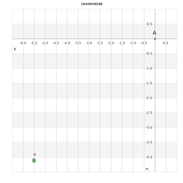
WDS 10449+0540 SLE 591 : NEIGHBORHOODS
|
|
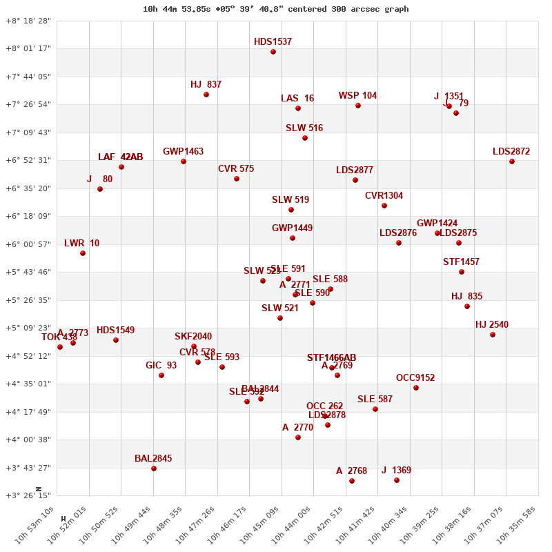
Click on the map to see the double of your interest.
Pass over with the mouse cursor to display the catalog designation.
|
| Show |
name |
coord_2000 |
discov# |
comp |
pa |
sep |
dist(') |
| Show |
|
10449+0540 |
SLE 591 |
|
126 |
6.7 |
1 |
| Show |
|
10446+0530 |
A 2771 |
|
109 |
0.6 |
11 |
| Show |
|
10458+0538 |
SLW 523 |
|
64 |
121.7 |
14 |
| Show |
|
10440+0525 |
SLE 590 |
|
164 |
12.9 |
20 |
| Show |
|
10434+0533 |
SLE 588 |
|
247 |
17.9 |
24 |
| Show |
|
10452+0515 |
SLW 521 |
|
139 |
34.7 |
25 |
| Show |
|
10447+0605 |
GWP1449 |
|
342 |
34.8 |
26 |
| Show |
|
10448+0622 |
SLW 519 |
|
171 |
168.8 |
43 |
| Show |
|
10433+0445 |
STF1466 |
AB |
239 |
6.8 |
60 |
| Show |
|
10433+0445 |
STF1466 |
AC |
210 |
333.8 |
60 |
| Show |
|
10410+0602 |
LDS2876 |
|
131 |
22.2 |
63 |
| Show |
|
10473+0445 |
SLE 593 |
|
334 |
6.4 |
65 |
| Show |
|
10432+0440 |
A 2769 |
|
205 |
0.5 |
66 |
| Show |
|
10483+0458 |
SKF2040 |
|
73 |
4.2 |
66 |
| Show |
|
10467+0641 |
CVR 575 |
|
244 |
29.0 |
68 |
| Show |
|
10415+0625 |
CVR1304 |
|
322 |
4.0 |
69 |
| Show |
|
10425+0640 |
LDS2877 |
|
274 |
5.6 |
71 |
| Show |
|
10481+0448 |
CVR 578 |
|
97 |
17.6 |
71 |
| Show |
|
10459+0426 |
BAL2844 |
|
329 |
5.0 |
76 |
| Show |
|
10464+0424 |
SLE 592 |
|
134 |
19.5 |
79 |
| Show |
|
10396+0607 |
GWP1424 |
|
101 |
97.3 |
85 |
| Show |
|
10436+0415 |
OCC 262 |
|
-1 |
0.1 |
87 |
| Show |
|
10443+0706 |
SLW 516 |
|
217 |
159.2 |
88 |
| Show |
|
10494+0439 |
GIC 93 |
|
356 |
702.2 |
91 |
| Show |
|
10486+0652 |
GWP1463 |
|
192 |
20.0 |
92 |
| Show |
|
10387+0544 |
STF1457 |
|
334 |
1.9 |
93 |
| Show |
|
10435+0410 |
LDS2878 |
|
261 |
6.2 |
93 |
| Show |
|
10418+0419 |
SLE 587 |
|
115 |
21.7 |
93 |
| Show |
|
10388+0603 |
LDS2875 |
|
40 |
46.2 |
94 |
| Show |
|
10403+0432 |
OCC9152 |
|
-1 |
0.2 |
96 |
| Show |
|
10385+0523 |
HJ 835 |
|
9 |
15.7 |
97 |
| Show |
|
10446+0402 |
A 2770 |
|
16 |
0.8 |
98 |
| Show |
|
10510+0502 |
HDS1549 |
|
354 |
0.5 |
100 |
| Show |
|
10446+0725 |
LAS 16 |
|
338 |
9.0 |
106 |
| Show |
|
10523+0555 |
LWR 10 |
|
92 |
26.7 |
111 |
| Show |
|
10509+0648 |
LAF 42 |
AB |
324 |
12.5 |
113 |
| Show |
|
10509+0648 |
LAF 42 |
AC |
338 |
13.9 |
113 |
| Show |
|
10509+0648 |
RAO 256 |
Aa,Ab |
214 |
0.1 |
113 |
| Show |
|
10424+0726 |
WSP 104 |
|
177 |
6.8 |
113 |
| Show |
|
10376+0505 |
HJ 2540 |
|
306 |
27.9 |
115 |
| Show |
|
10516+0635 |
J 80 |
|
219 |
3.9 |
115 |
| Show |
|
10526+0500 |
A 2773 |
|
346 |
1.7 |
122 |
| Show |
|
10478+0733 |
HJ 837 |
|
350 |
17.4 |
122 |
| Show |
|
10530+0458 |
TOK 438 |
|
197 |
0.1 |
129 |
| Show |
|
10426+0335 |
A 2768 |
|
235 |
0.6 |
130 |
| Show |
|
10389+0721 |
J 79 |
|
135 |
1.4 |
136 |
| Show |
|
10391+0726 |
J 1351 |
|
96 |
6.5 |
137 |
| Show |
|
10410+0336 |
J 1369 |
|
121 |
7.5 |
137 |
| Show |
|
10497+0343 |
BAL2845 |
|
158 |
5.7 |
138 |
| Show |
|
10369+0652 |
LDS2872 |
|
194 |
3.4 |
140 |
| Show |
|
10454+0759 |
HDS1537 |
|
277 |
1.0 |
141 |
|
|
WDS 10449+0540 : COMPONENTS
10449+0540 A
| Coord arcsec 2000 |
104453.85+053940.8 |
|
Mag |
11.2 |
|
PmRA |
-49.00 |
|
PmDE |
18.0 |
|
| Tycho2 |
0260-00593-1 |
|
| Tycho2 |
0260-00593-1 |
|
Pflag |
|
|
RAmdeg |
161.22439349 |
|
DEmdeg |
5.66135928 |
|
| PmRA |
-46.3 |
|
PmDE |
19.3 |
|
E RAmdeg |
64 |
|
E DEmdeg |
78 |
|
| E pmRA |
2.4 |
|
E pmDE |
2.3 |
|
EpRAm |
1982.82 |
|
EpDEm |
1976.82 |
|
| Num |
3 |
|
Q RAmdeg |
4.3 |
|
Q DEmdeg |
1.6 |
|
Q pmRA |
4.3 |
|
| Q pmDE |
1.6 |
|
BTmag |
12.127 |
|
E BTmag |
0.167 |
|
VTmag |
11.256 |
|
| E VTmag |
0.113 |
|
Prox |
999 |
|
TYC |
|
|
HIP |
|
|
| CCDM |
|
|
RAdeg |
161.22449917 |
|
DEdeg |
5.66131500 |
|
EpRA 1990 |
1.81 |
|
| EpDE 1990 |
1.72 |
|
E RAdeg |
67.6 |
|
E DEdeg |
84.9 |
|
Posflg |
|
|
| Corr |
0.2 |
|
10449+0540 B
| Coord arcsec 2000 |
104454.22+053936.9 |
|
Mag |
12.2 |
|
PmRA |
13.00 |
|
PmDE |
-16.0 |
|
| Delta magnitude |
1 |
|
Coordinate calculated |
yes |
|