10291+0922 HEI 496
10h 29m 05.46s +09° 22' 31.8" P.A. 343.00 sep 1.8 mag 11.10,11.60
| Coord 2000 |
10291+0922 |
|
Discov num |
HEI 496 |
|
Comp |
|
|
Coord arcsec 2000 |
10 29 05.46 +09 22 31.8 |
|
| Date first |
1988 |
|
Date last |
2016 |
|
Obs |
5 |
|
| Pa first |
338 |
|
Pa last |
343 |
|
P.A. Now (θ) |
343° |
|
| Sep first |
2.4 |
|
Sep last |
1.804 |
|
Sep. Now (ρ) |
1.804" |
|
| Mag pri |
11.10 |
|
Mag sec |
11.60 |
|
delta mag (ΔM) |
0.5 |
|
Spectral class |
|
|
| Pri motion ra |
-116 |
|
Sec motion ra |
|
|
| Pri motion dec |
-025 |
|
Sec motion dec |
|
|
| Notes |
|
|
Nature of this double is uncertain.
OTHER CATALOGS AND DESIGNATIONS
| Constellation |
Leo |
|
Gaia DR2 |
3864079001291514240 |
|
WDS 10291+0922 HEI 496 : NOTES
No records found.
DISCOVERER
| discov |
author |
| HEI |
Heintz, W.D. |
WDS HISTORIC DATA
| coord_2000 |
discov_num |
comp |
epoch |
obs |
pa |
sep |
mag_pri |
mag_sec |
spectr |
dm_number |
notes |
coord_arcsec_2000 |
| 10291+0922 |
HEI 496 |
|
2002 |
2 |
344 |
1.7 |
11.10 |
11.60 |
|
+10 2159 |
|
102905.46+092231.8 |
| 10291+0922 |
HEI 496 |
|
2015 |
3 |
343 |
1.8 |
11.10 |
11.60 |
|
+10 2159 |
|
102905.46+092231.8 |
| 10291+0922 |
HEI 496 |
|
2016 |
4 |
343 |
1.8 |
11.10 |
11.60 |
|
+10 2159 |
|
102905.46+092231.8 |
If you need more information about this double, apply for a
data request form to the WDS.
WDS 10291+0922 HEI 496 : VISUAL OBSERVATIONS REPORTS
No records found.
WDS 10291+0922 HEI 496 : MEASURES
No records found.
WDS 10291+0922 : VIRTUAL EYEPIECE

Click on the map to see the double of your interest.
Pass over with the mouse cursor to display the catalog designation.
|
|
WDS 10291+0922 : ALADIN DSS IMAGE @ 10h 29m 05.46s +09° 22' 31.8"
WDS 10291+0922 HEI 496 : NEIGHBORHOODS
|
|
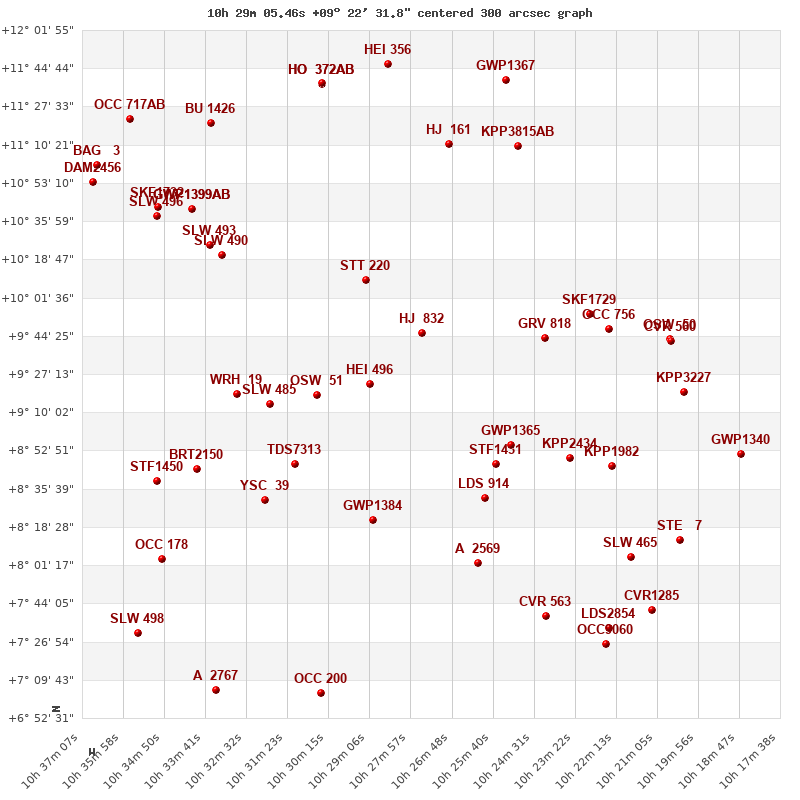
Click on the map to see the double of your interest.
Pass over with the mouse cursor to display the catalog designation.
|
| Show |
name |
coord_2000 |
discov# |
comp |
pa |
sep |
dist(') |
| Show |
|
10291+0922 |
HEI 496 |
|
343 |
1.8 |
0 |
| Show |
|
10306+0918 |
OSW 51 |
|
313 |
9.4 |
23 |
| Show |
|
10276+0946 |
HJ 832 |
|
132 |
37.8 |
32 |
| Show |
|
10319+0914 |
SLW 485 |
|
63 |
11.5 |
43 |
| Show |
|
10292+1009 |
STT 220 |
|
112 |
0.4 |
47 |
| Show |
|
10312+0847 |
TDS7313 |
|
273 |
0.5 |
48 |
| Show |
|
10328+0918 |
WRH 19 |
|
98 |
0.0 |
56 |
| Show |
|
10290+0822 |
GWP1384 |
|
356 |
102.2 |
61 |
| Show |
|
10256+0847 |
STF1431 |
|
76 |
3.6 |
64 |
| Show |
|
10252+0855 |
GWP1365 |
|
108 |
47.7 |
65 |
| Show |
|
10320+0831 |
YSC 39 |
|
22 |
0.8 |
68 |
| Show |
|
10259+0831 |
LDS 914 |
|
286 |
45.5 |
70 |
| Show |
|
10241+0943 |
GRV 818 |
|
299 |
45.1 |
76 |
| Show |
|
10339+0845 |
BRT2150 |
|
101 |
3.3 |
81 |
| Show |
|
10332+1021 |
SLW 490 |
|
241 |
22.0 |
85 |
| Show |
|
10235+0850 |
KPP2434 |
|
291 |
21.3 |
89 |
| Show |
|
10335+1025 |
SLW 493 |
|
241 |
179.7 |
91 |
| Show |
|
10261+0802 |
A 2569 |
|
305 |
2.0 |
93 |
| Show |
|
10229+0954 |
SKF1729 |
|
298 |
1.3 |
97 |
| Show |
|
10350+0839 |
STF1450 |
|
155 |
2.1 |
99 |
| Show |
|
10224+0948 |
OCC 756 |
|
-1 |
0.1 |
102 |
| Show |
|
10223+0846 |
KPP1982 |
|
285 |
15.7 |
107 |
| Show |
|
10341+1041 |
GWP1399 |
AB |
341 |
18.7 |
108 |
| Show |
|
10341+1041 |
GWP1399 |
AC |
186 |
83.1 |
108 |
| Show |
|
10269+1110 |
HJ 161 |
|
211 |
32.9 |
114 |
| Show |
|
10350+1038 |
SLW 496 |
|
75 |
37.7 |
116 |
| Show |
|
10349+0804 |
OCC 178 |
|
-1 |
0.1 |
117 |
| Show |
|
10350+1042 |
SKF1732 |
|
208 |
1.8 |
119 |
| Show |
|
10250+1110 |
KPP3815 |
AB |
223 |
4.5 |
124 |
| Show |
|
10207+0943 |
OSW 50 |
|
179 |
73.1 |
126 |
| Show |
|
10207+0942 |
CVR 560 |
|
254 |
8.6 |
126 |
| Show |
|
10242+0738 |
CVR 563 |
|
146 |
22.4 |
128 |
| Show |
|
10203+0919 |
KPP3227 |
|
18 |
2.5 |
130 |
| Show |
|
10218+0805 |
SLW 465 |
|
164 |
143.1 |
134 |
| Show |
|
10335+1120 |
BU 1426 |
|
200 |
2.7 |
135 |
| Show |
|
10304+1138 |
HO 372 |
AB |
84 |
14.5 |
137 |
| Show |
|
10304+1138 |
HO 372 |
AC |
203 |
47.0 |
137 |
| Show |
|
10304+1138 |
HO 372 |
BC |
216 |
55.9 |
137 |
| Show |
|
10305+0704 |
OCC 200 |
|
-1 |
0.1 |
141 |
| Show |
|
10286+1146 |
HEI 356 |
|
206 |
1.6 |
145 |
| Show |
|
10368+1053 |
DAM2456 |
|
17 |
31.5 |
146 |
| Show |
|
10205+0813 |
STE 7 |
|
124 |
20.7 |
146 |
| Show |
|
10356+0731 |
SLW 498 |
|
79 |
179.1 |
148 |
| Show |
|
10225+0733 |
LDS2854 |
|
348 |
54.6 |
148 |
| Show |
|
10253+1139 |
GWP1367 |
|
167 |
58.8 |
148 |
| Show |
|
10367+1101 |
BAG 3 |
|
69 |
0.1 |
150 |
| Show |
|
10334+0705 |
A 2767 |
|
53 |
5.4 |
152 |
| Show |
|
10225+0726 |
OCC9060 |
|
90 |
4.1 |
153 |
| Show |
|
10212+0741 |
CVR1285 |
|
59 |
3.5 |
155 |
| Show |
|
10358+1122 |
OCC 717 |
AB |
-1 |
0.1 |
156 |
| Show |
|
10187+0851 |
GWP1340 |
|
137 |
15.6 |
157 |
|
|
WDS 10291+0922 : COMPONENTS
10291+0922 A
| Coord arcsec 2000 |
102905.46+092231.8 |
|
Mag |
11.1 |
|
PmRA |
-116.00 |
|
PmDE |
-25.0 |
|
10291+0922 B
| Coord arcsec 2000 |
102905.42+092233.5 |
|
Mag |
11.6 |
|
Delta magnitude |
0.5 |
|
Coordinate calculated |
yes |
|