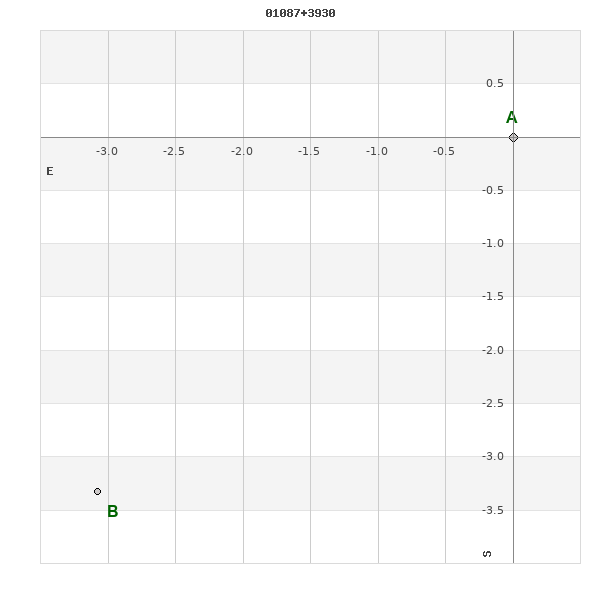
01087+3930 ES 1946
01h 08m 42.61s +39° 31' 11.7" P.A. 137.00 sep 4.5 mag 9.64,11.60
| Coord 2000 |
01087+3930 |
|
Discov num |
ES 1946 |
|
Comp |
|
|
Coord arcsec 2000 |
01 08 42.61 +39 31 11.7 |
|
| Date first |
1922 |
|
Date last |
2015 |
|
Obs |
6 |
|
| Pa first |
134 |
|
Pa last |
137.2 |
|
P.A. Now (θ) |
137.2° |
|
| Sep first |
4.3 |
|
Sep last |
4.529 |
|
Sep. Now (ρ) |
4.529" |
|
| Mag pri |
9.64 |
|
Mag sec |
11.60 |
|
delta mag (ΔM) |
1.96 |
|
Spectral class |
|
|
| Pri motion ra |
+037 |
|
Sec motion ra |
|
|
| Pri motion dec |
+000 |
|
Sec motion dec |
|
|
| Notes |
|
|
Nature of this double is uncertain.
OTHER CATALOGS AND DESIGNATIONS
| Constellation |
Andromeda |
|
Tycho2 |
2803-00262-1 |
|
Gaia DR2 |
371046760187343232 |
|
WDS 01087+3930 ES 1946 : NOTES
No records found.
DISCOVERER
| discov |
author |
| ES |
Espin, T.E. |
WDS HISTORIC DATA
| coord_2000 |
discov_num |
comp |
epoch |
obs |
pa |
sep |
mag_pri |
mag_sec |
spectr |
dm_number |
notes |
coord_arcsec_2000 |
| 01087+3930 |
ES 1946 |
|
1998 |
3 |
138 |
4.2 |
9.64 |
11.60 |
|
+38 196 |
D |
010842.61+393111.7 |
| 01087+3930 |
ES 1946 |
|
2015 |
4 |
137 |
4.5 |
9.64 |
11.60 |
|
+38 196 |
|
010842.61+393111.7 |
If you need more information about this double, apply for a
data request form to the WDS.
WDS 01087+3930 ES 1946 : VISUAL OBSERVATIONS REPORTS
No records found.
WDS 01087+3930 ES 1946 : MEASURES
No records found.
WDS 01087+3930 : VIRTUAL EYEPIECE
Click on the map to see the double of your interest.
Pass over with the mouse cursor to display the catalog designation.
|
|
WDS 01087+3930 : ALADIN DSS IMAGE @ 01h 08m 42.61s +39° 31' 11.7"
WDS 01087+3930 ES 1946 : NEIGHBORHOODS
|
|
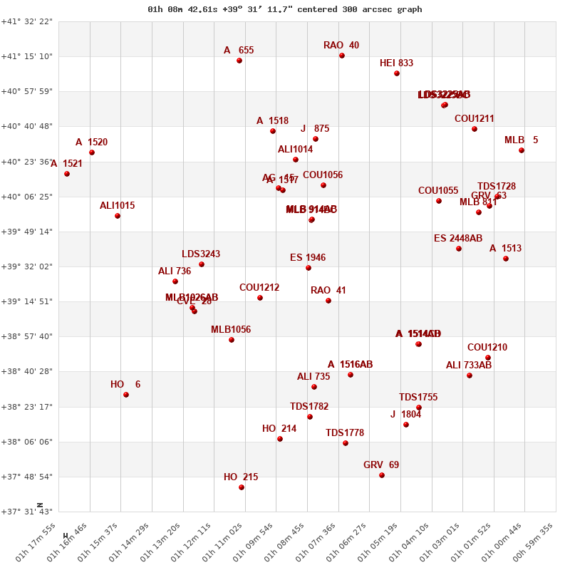
Click on the map to see the double of your interest.
Pass over with the mouse cursor to display the catalog designation.
|
| Show |
name |
coord_2000 |
discov# |
comp |
pa |
sep |
dist(') |
| Show |
|
01087+3930 |
ES 1946 |
|
137 |
4.5 |
1 |
| Show |
|
01080+3915 |
RAO 41 |
|
245 |
26.1 |
19 |
| Show |
|
01085+3956 |
MLB 914 |
BC |
139 |
6.2 |
24 |
| Show |
|
01085+3956 |
MLB 914 |
AB |
137 |
27.5 |
25 |
| Show |
|
01105+3917 |
COU1212 |
|
158 |
0.3 |
26 |
| Show |
|
01096+4010 |
A 1517 |
|
257 |
2.0 |
40 |
| Show |
|
01081+4012 |
COU1056 |
|
96 |
0.7 |
42 |
| Show |
|
01099+4011 |
AG 15 |
|
70 |
2.8 |
42 |
| Show |
|
01127+3933 |
LDS3243 |
|
46 |
80.5 |
46 |
| Show |
|
01115+3856 |
MLB1056 |
|
42 |
15.6 |
49 |
| Show |
|
01129+3910 |
CVE 28 |
|
322 |
7.8 |
54 |
| Show |
|
01130+3911 |
MLB1026 |
AB |
253 |
3.9 |
54 |
| Show |
|
01130+3911 |
FYM 360 |
AC |
349 |
18.0 |
54 |
| Show |
|
01092+4024 |
ALI1014 |
|
338 |
12.8 |
54 |
| Show |
|
01072+3839 |
A 1516 |
AB |
43 |
0.1 |
56 |
| Show |
|
01072+3839 |
STTA 11 |
AB,C |
165 |
60.8 |
56 |
| Show |
|
01136+3925 |
ALI 736 |
|
183 |
3.1 |
58 |
| Show |
|
01085+3833 |
ALI 735 |
|
77 |
10.0 |
59 |
| Show |
|
01047+3854 |
A 1514 |
AB |
291 |
7.2 |
61 |
| Show |
|
01047+3854 |
A 1514 |
AC |
263 |
22.0 |
61 |
| Show |
|
01047+3854 |
A 1514 |
CD |
121 |
1.6 |
61 |
| Show |
|
01084+4035 |
J 875 |
|
337 |
3.4 |
64 |
| Show |
|
01039+4004 |
COU1055 |
|
296 |
1.4 |
65 |
| Show |
|
01032+3940 |
ES 2448 |
AB |
66 |
2.9 |
65 |
| Show |
|
01100+4039 |
A 1518 |
|
280 |
12.0 |
70 |
| Show |
|
01086+3818 |
TDS1782 |
|
220 |
0.5 |
73 |
| Show |
|
01024+3958 |
MLB 811 |
|
196 |
7.1 |
78 |
| Show |
|
01020+4001 |
GRV 63 |
|
188 |
28.5 |
83 |
| Show |
|
01046+3823 |
TDS1755 |
|
163 |
1.1 |
84 |
| Show |
|
01015+3936 |
A 1513 |
|
299 |
3.7 |
85 |
| Show |
|
01098+3807 |
HO 214 |
|
249 |
3.0 |
85 |
| Show |
|
01158+3957 |
ALI1015 |
|
64 |
8.0 |
86 |
| Show |
|
01028+3838 |
ALI 733 |
AB |
8 |
5.8 |
87 |
| Show |
|
01073+3805 |
TDS1778 |
|
111 |
1.5 |
88 |
| Show |
|
01051+3814 |
J 1804 |
|
310 |
5.2 |
88 |
| Show |
|
01017+4006 |
TDS1728 |
|
202 |
2.8 |
88 |
| Show |
|
01021+3847 |
COU1210 |
|
79 |
0.4 |
89 |
| Show |
|
01026+4040 |
COU1211 |
|
19 |
3.2 |
99 |
| Show |
|
01037+4051 |
LDS3225 |
BC |
99 |
2.7 |
99 |
| Show |
|
01037+4051 |
LDS3225 |
AB |
119 |
28.3 |
99 |
| Show |
|
01037+4051 |
BWL 5 |
Aa,Ab |
309 |
0.3 |
99 |
| Show |
|
01037+4051 |
BWL 5 |
AD |
334 |
12.5 |
99 |
| Show |
|
01154+3829 |
HO 6 |
|
123 |
1.3 |
100 |
| Show |
|
01055+4107 |
HEI 833 |
|
229 |
2.0 |
103 |
| Show |
|
01075+4116 |
RAO 40 |
|
335 |
6.2 |
106 |
| Show |
|
01112+4113 |
A 655 |
|
5 |
0.2 |
107 |
| Show |
|
01060+3749 |
GRV 69 |
|
332 |
63.1 |
107 |
| Show |
|
01008+4029 |
MLB 5 |
|
342 |
7.2 |
108 |
| Show |
|
01167+4028 |
A 1520 |
|
239 |
3.0 |
108 |
| Show |
|
01112+3743 |
HO 215 |
|
225 |
0.1 |
112 |
| Show |
|
01176+4018 |
A 1521 |
|
115 |
0.1 |
113 |
|
|
WDS 01087+3930 : COMPONENTS
01087+3930 A
| Coord arcsec 2000 |
010842.61+393111.7 |
|
Mag |
9.64 |
|
PmRA |
37.00 |
|
PmDE |
0.0 |
|
| Tycho2 |
2803-00262-1 |
|
| Tycho2 |
2803-00262-1 |
|
Pflag |
|
|
RAmdeg |
17.17756575 |
|
DEmdeg |
39.51994093 |
|
| PmRA |
36.8 |
|
PmDE |
0.4 |
|
E RAmdeg |
13 |
|
E DEmdeg |
14 |
|
| E pmRA |
3.7 |
|
E pmDE |
3.2 |
|
EpRAm |
1991.45 |
|
EpDEm |
1990.73 |
|
| Num |
3 |
|
Q RAmdeg |
4.9 |
|
Q DEmdeg |
4.5 |
|
Q pmRA |
4.9 |
|
| Q pmDE |
4.3 |
|
BTmag |
10.181 |
|
E BTmag |
0.026 |
|
VTmag |
9.637 |
|
| E VTmag |
0.022 |
|
Prox |
999 |
|
TYC |
T |
|
HIP |
|
|
| CCDM |
|
|
RAdeg |
17.17745500 |
|
DEdeg |
39.51994389 |
|
EpRA 1990 |
1.88 |
|
| EpDE 1990 |
1.82 |
|
E RAdeg |
13.4 |
|
E DEdeg |
14.9 |
|
Posflg |
|
|
| Corr |
0.0 |
|
01087+3930 B
| Coord arcsec 2000 |
010842.88+393108.4 |
|
Mag |
11.6 |
|
Delta magnitude |
1.96 |
|
Coordinate calculated |
yes |
|