03023+1820 A 2414
03h 02m 15.57s +18° 19' 45.0" P.A. 72.00 sep 0.5 mag 10.54,10.41 Sp G5 dist. 93.72 pc (305.71 l.y.)
| Coord 2000 |
03023+1820 |
|
Discov num |
A 2414 |
|
Comp |
|
|
Coord arcsec 2000 |
03 02 15.57 +18 19 45.0 |
|
| Date first |
1910 |
|
Date last |
2022 |
|
Obs |
31 |
|
| Pa first |
311 |
|
Pa last |
71.8 |
|
P.A. Now (θ) |
71.8° |
|
| Sep first |
0.2 |
|
Sep last |
0.538 |
|
Sep. Now (ρ) |
0.538" |
|
| Mag pri |
10.54 |
|
Mag sec |
10.41 |
|
delta mag (ΔM) |
0.13 |
|
Spectral class |
G5 (yellow) |
|
| Pri motion ra |
+113 |
|
Sec motion ra |
+113 |
|
| Pri motion dec |
-066 |
|
Sec motion dec |
-066 |
|
| Notes |
N
O
(See Notes, Orbital solution) |
|
This double is physical.
OTHER CATALOGS AND DESIGNATIONS
| Constellation |
Aries |
|
HIP |
14132 |
|
Tycho2 |
1228-01100-1 |
|
Gaia DR2 |
35694167527007488 |
|
| ADS |
2301 |
|
BD |
BD+17 477 |
|
Distance |
93.72 |
|
Distance ly |
305.71 |
|
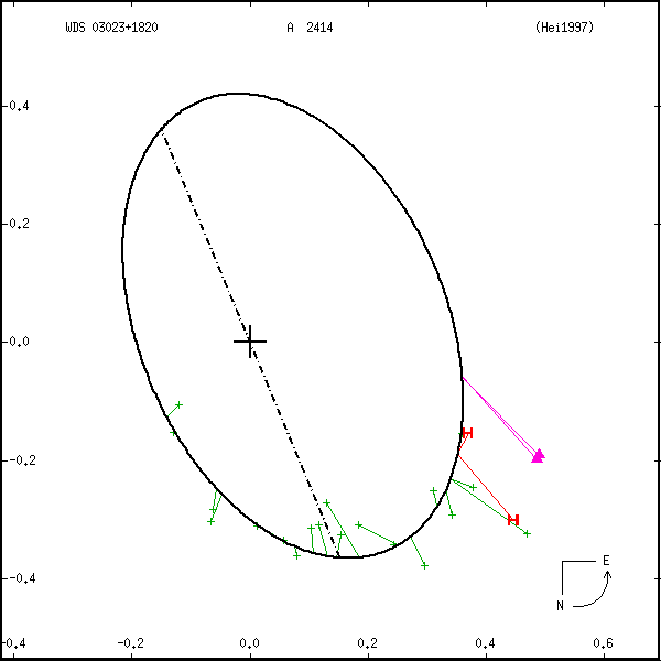
ORBITAL ELEMENTS
| Period (P) | 256y | |
Periastron (T) | 1906y | |
Semi-major axis (a) | 0.432a | |
| Eccentricity (e) | 0.3 | |
Inclination (i) | 53° | |
Longitude of periastron (ω) | 269° | |
| Node (Ω) | 22.7° | |
Notes | n | |
Reference | Hei1997 | |
| Equinox | 2000 | |
Last observation | | |
Grade | 5 | (1=Definitive, 9=Indet.) |
| label |
theta |
rho |
| 2000 |
70.2 |
0.382 |
| 2001 |
71.2 |
0.380 |
| 2002 |
72.3 |
0.378 |
| 2003 |
73.3 |
0.377 |
| 2004 |
74.4 |
0.375 |
| 2005 |
75.5 |
0.373 |
| 2006 |
76.6 |
0.371 |
| 2007 |
77.7 |
0.369 |
| 2008 |
78.8 |
0.367 |
| 2009 |
79.9 |
0.365 |
| 2010 |
81.0 |
0.363 |
| 2011 |
82.2 |
0.362 |
| 2012 |
83.3 |
0.360 |
| 2013 |
84.5 |
0.358 |
| 2014 |
85.7 |
0.357 |
| 2015 |
86.9 |
0.355 |
| 2016 |
88.1 |
0.354 |
| 2017 |
89.3 |
0.352 |
| 2018 |
90.5 |
0.351 |
| 2019 |
91.7 |
0.349 |
| 2020 |
93.0 |
0.348 |
| 2021 |
94.2 |
0.347 |
| 2022 |
95.5 |
0.346 |
| 2023 |
96.7 |
0.345 |
| 2024 |
98.0 |
0.344 |
| 2025 |
99.3 |
0.343 |
| 2026 |
100.6 |
0.342 |
| 2027 |
101.9 |
0.341 |
| 2028 |
103.2 |
0.340 |
| 2029 |
104.5 |
0.340 |
| 2030 |
105.8 |
0.339 |
| 2031 |
107.1 |
0.339 |
| 2032 |
108.4 |
0.339 |
| 2033 |
109.7 |
0.338 |
| 2034 |
111.0 |
0.338 |
| 2035 |
112.4 |
0.338 |
| 2036 |
113.7 |
0.338 |
| 2037 |
115.0 |
0.338 |
| 2038 |
116.3 |
0.338 |
| 2039 |
117.6 |
0.338 |
| 2040 |
118.9 |
0.339 |
| 2041 |
120.3 |
0.339 |
| 2042 |
121.6 |
0.340 |
| 2043 |
122.9 |
0.340 |
| 2044 |
124.2 |
0.341 |
| 2045 |
125.5 |
0.342 |
| 2046 |
126.7 |
0.342 |
| 2047 |
128.0 |
0.343 |
| 2048 |
129.3 |
0.344 |
| 2049 |
130.6 |
0.345 |
| 2050 |
131.8 |
0.346 |
|
|
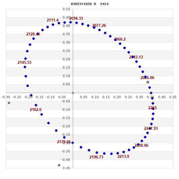
Note: Theta is PA, Rho is Sep. For yearly orbits, data refer to Jan 1st.
Measures: green=micrometric, blue=interferometric, purple=photographic
|
|
WDS 03023+1820 A 2414 : NOTES
| discov_num |
notes |
refcode |
| A 2414 |
A premature orbit has been computed. |
|
REFERENCES
| refcode |
metd |
author |
reference |
| Hei1997 |
orb - |
Heintz, W.D. |
1997ApJS..111..335H |
| Hei1997 |
|
ApJS 111, 335, 1997 |
|
DISCOVERER
| discov |
author |
| A |
Aitken, R.G. |
WDS HISTORIC DATA
| coord_2000 |
discov_num |
comp |
epoch |
obs |
pa |
sep |
mag_pri |
mag_sec |
spectr |
dm_number |
notes |
coord_arcsec_2000 |
| 03023+1820 |
A 2414 |
|
1996 |
20 |
67 |
0.4 |
10.54 |
10.41 |
G5 |
+17 477 |
NOD |
030215.57+181945.0 |
| 03023+1820 |
A 2414 |
|
2009 |
23 |
68 |
0.5 |
10.54 |
10.41 |
G5 |
+17 477 |
NOD |
030215.57+181945.0 |
| 03023+1820 |
A 2414 |
|
2012 |
25 |
69 |
0.5 |
10.54 |
10.41 |
G5 |
+17 477 |
NO |
030215.57+181945.0 |
| 03023+1820 |
A 2414 |
|
2013 |
26 |
68 |
0.5 |
10.54 |
10.41 |
G5 |
+17 477 |
NO |
030215.57+181945.0 |
| 03023+1820 |
A 2414 |
|
2022 |
31 |
72 |
0.5 |
10.54 |
10.41 |
G5 |
+17 477 |
NO |
030215.57+181945.0 |
If you need more information about this double, apply for a
data request form to the WDS.
WDS 03023+1820 A 2414 : VISUAL OBSERVATIONS REPORTS
No records found.
WDS 03023+1820 A 2414 : MEASURES
No records found.
WDS 03023+1820 : VIRTUAL EYEPIECE

Click on the map to see the double of your interest.
Pass over with the mouse cursor to display the catalog designation.
|
|
WDS 03023+1820 : ALADIN DSS IMAGE @ 03h 02m 15.57s +18° 19' 45.0"
WDS 03023+1820 A 2414 : NEIGHBORHOODS
|
|
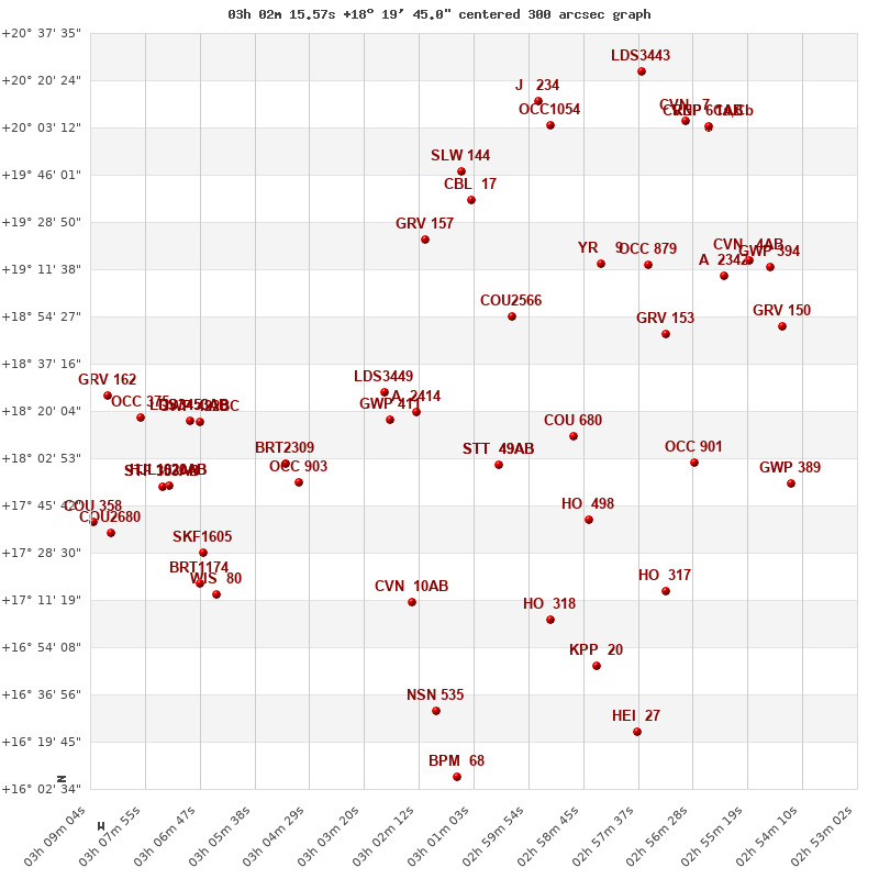
Click on the map to see the double of your interest.
Pass over with the mouse cursor to display the catalog designation.
|
| Show |
name |
coord_2000 |
discov# |
comp |
pa |
sep |
dist(') |
| Show |
|
03023+1820 |
A 2414 |
|
72 |
0.5 |
1 |
| Show |
|
03028+1817 |
GWP 411 |
|
188 |
7.5 |
9 |
| Show |
|
03029+1827 |
LDS3449 |
|
123 |
55.0 |
12 |
| Show |
|
03005+1800 |
STT 49 |
AB |
47 |
2.3 |
32 |
| Show |
|
03005+1800 |
STT 49 |
AC |
208 |
147.1 |
32 |
| Show |
|
03050+1800 |
BRT2309 |
|
90 |
1.4 |
44 |
| Show |
|
03047+1754 |
OCC 903 |
|
-1 |
0.1 |
44 |
| Show |
|
03002+1853 |
COU2566 |
|
59 |
0.8 |
45 |
| Show |
|
02590+1811 |
COU 680 |
|
102 |
0.4 |
48 |
| Show |
|
03020+1922 |
GRV 157 |
|
179 |
66.8 |
63 |
| Show |
|
03070+1816 |
GWP 422 |
BC |
91 |
214.2 |
65 |
| Show |
|
02586+1741 |
HO 498 |
|
62 |
0.4 |
65 |
| Show |
|
03070+1816 |
LDS3453 |
AB |
259 |
173.0 |
68 |
| Show |
|
03070+1816 |
LDS3453 |
AC |
129 |
56.6 |
68 |
| Show |
|
03024+1711 |
CVN 10 |
AB |
132 |
0.8 |
70 |
| Show |
|
03024+1711 |
BNK 2 |
Ba,Bb |
57 |
0.1 |
70 |
| Show |
|
02584+1914 |
YR 9 |
|
239 |
0.6 |
77 |
| Show |
|
03074+1753 |
HJL1020 |
AB |
359 |
105.8 |
79 |
| Show |
|
03074+1753 |
OCC 395 |
Aa,Ab |
-1 |
0.0 |
79 |
| Show |
|
03011+1937 |
CBL 17 |
|
194 |
30.9 |
79 |
| Show |
|
02570+1848 |
GRV 153 |
|
277 |
7.6 |
80 |
| Show |
|
03075+1753 |
STF 353 |
AB |
52 |
12.7 |
81 |
| Show |
|
03075+1753 |
FOX 128 |
AC |
17 |
30.1 |
81 |
| Show |
|
03067+1729 |
SKF1605 |
|
240 |
56.4 |
82 |
| Show |
|
03080+1818 |
OCC 375 |
|
-1 |
0.3 |
83 |
| Show |
|
02564+1801 |
OCC 901 |
|
-1 |
-1.0 |
86 |
| Show |
|
02595+1704 |
HO 318 |
|
26 |
3.2 |
86 |
| Show |
|
02574+1913 |
OCC 879 |
|
-1 |
0.1 |
88 |
| Show |
|
03013+1947 |
SLW 144 |
|
99 |
12.3 |
89 |
| Show |
|
03064+1713 |
WIS 80 |
|
217 |
999.9 |
90 |
| Show |
|
03068+1717 |
BRT1174 |
|
152 |
4.2 |
90 |
| Show |
|
03087+1825 |
GRV 162 |
|
232 |
10.2 |
92 |
| Show |
|
02570+1714 |
HO 317 |
|
309 |
3.6 |
100 |
| Show |
|
03087+1736 |
COU2680 |
|
245 |
1.5 |
102 |
| Show |
|
02558+1909 |
A 2342 |
|
22 |
0.4 |
104 |
| Show |
|
03090+1740 |
COU 358 |
|
112 |
2.1 |
105 |
| Show |
|
02585+1648 |
KPP 20 |
|
196 |
7.3 |
107 |
| Show |
|
03018+1631 |
NSN 535 |
|
309 |
16.2 |
109 |
| Show |
|
02595+2004 |
OCC1054 |
|
-1 |
0.0 |
112 |
| Show |
|
02546+1850 |
GRV 150 |
|
353 |
12.2 |
114 |
| Show |
|
02553+1915 |
CVN 4 |
AB |
161 |
1.0 |
114 |
| Show |
|
02544+1754 |
GWP 389 |
|
301 |
9.5 |
115 |
| Show |
|
02549+1913 |
GWP 394 |
|
160 |
9.7 |
118 |
| Show |
|
02597+2013 |
J 234 |
|
20 |
5.4 |
119 |
| Show |
|
02566+2006 |
CVN 7 |
|
221 |
9.3 |
133 |
| Show |
|
03014+1607 |
BPM 68 |
|
75 |
108.5 |
134 |
| Show |
|
02577+1624 |
HEI 27 |
|
133 |
2.2 |
134 |
| Show |
|
02561+2003 |
CVN 6 |
Ca,Cb |
51 |
0.4 |
136 |
| Show |
|
02561+2003 |
REP 1 |
AB |
58 |
4.1 |
136 |
| Show |
|
02561+2003 |
HER 6 |
AC |
203 |
15.7 |
136 |
| Show |
|
02576+2024 |
LDS3443 |
|
103 |
373.4 |
141 |
|
|
WDS 03023+1820 : COMPONENTS
03023+1820 A
| Coord arcsec 2000 |
030215.57+181945.0 |
|
Mag |
10.54 |
|
Spectral class |
G5 (yellow) |
|
PmRA |
113.00 |
|
| PmDE |
-66.0 |
|
| Ccdm |
03023+1820 |
|
RComp |
|
|
Comp |
A |
|
Note1 |
|
|
| Note2 |
|
|
Discov num |
|
|
DRAs |
-2.44 |
|
DDEs |
-14.0 |
|
| R dRAs |
10 |
|
Year |
|
|
Theta |
|
|
Rho |
|
|
| Obs |
2 |
|
Vmag |
10.2 |
|
Sp |
G5 |
|
PmNote |
* |
|
| PmRA |
105 |
|
PmDE |
-48 |
|
Dm number |
+17 477 |
|
Cat1 |
BD |
|
| Name2 |
+18 231 |
|
Cat2 |
AGK2/3 |
|
HD |
|
|
M HD |
|
|
| ADS BDS |
A 2301 |
|
M ADS BDS |
|
|
N IDS |
|
|
IDS |
02566N1755A |
|
| HIC |
14132 |
|
03023+1820 B
| Coord arcsec 2000 |
030215.61+181945.2 |
|
Mag |
10.41 |
|
PmRA |
113.00 |
|
PmDE |
-66.0 |
|
| HIP |
14132 |
|
Tycho2 |
1228-01100-1 |
|
BD |
BD+17 477 |
|
Delta magnitude |
0.13 |
|
| Coordinate calculated |
yes |
|
| Tycho2 |
1228-01100-1 |
|
Pflag |
|
|
RAmdeg |
45.56495013 |
|
DEmdeg |
18.32919626 |
|
| PmRA |
112.6 |
|
PmDE |
-65.9 |
|
E RAmdeg |
17 |
|
E DEmdeg |
20 |
|
| E pmRA |
1.0 |
|
E pmDE |
1.0 |
|
EpRAm |
1987.42 |
|
EpDEm |
1984.86 |
|
| Num |
8 |
|
Q RAmdeg |
0.8 |
|
Q DEmdeg |
0.9 |
|
Q pmRA |
0.9 |
|
| Q pmDE |
0.9 |
|
BTmag |
10.434 |
|
E BTmag |
0.037 |
|
VTmag |
9.791 |
|
| E VTmag |
0.029 |
|
Prox |
999 |
|
TYC |
T |
|
HIP |
14132 |
|
| CCDM |
AB |
|
RAdeg |
45.56468000 |
|
DEdeg |
18.32934806 |
|
EpRA 1990 |
1.76 |
|
| EpDE 1990 |
1.64 |
|
E RAdeg |
17.7 |
|
E DEdeg |
23.1 |
|
Posflg |
P |
|
| Corr |
-0.2 |
|
| Catalog |
H |
|
HIP |
14132 |
|
Proxy |
H |
|
RAhms |
03 02 15.51 |
|
| DEdms |
+18 19 45.6 |
|
Vmag |
9.6 |
|
VarFlag |
|
|
R Vmag |
H |
|
| RAdeg |
45.5646 |
|
DEdeg |
18.3293 |
|
AstroRef |
A |
|
Plx |
11.94 |
|
| CCDM |
114.80 |
|
N CCDM |
I |
|
Nsys |
1 |
|
Ncomp |
2 |
|
| MultFlag |
C |
|
Source |
|
|
Qual |
A |
|
M HIP |
AB |
|
| Theta |
56 |
|
Rho |
0.538 |
|
HD |
|
|
BD |
BD+17 477 |
|
| CD |
|
|
CP |
|
|
Dm number |
+17 477 |
|
VIred |
0.94 |
|
| SpType |
G5 |
|
R SpType |
|
|
Coord arcsec 2000 |
030215.51+181945.6 |
|
| HIP |
14132 |
|
Sn |
15 |
|
So |
3 |
|
Nc |
2 |
|
| RArad |
0.7952525892 |
|
DErad |
0.3199072278 |
|
Plx |
10.67 |
|
PmRA |
112.72 |
|
| PmDE |
-64.95 |
|
E RArad |
2.12 |
|
E DErad |
1.7 |
|
E Plx |
2.48 |
|
| E pmRA |
3 |
|
E pmDE |
3.25 |
|
Hpmag |
|
|
E Hpmag |
0.0024 |
|
| SHp |
0.021 |
|
VA |
0 |
|
BV |
0.655 |
|
E BV |
0.039 |
|
| VI |
0.72 |
|
| Ccdm |
03023+1820 |
|
RComp |
|
|
Comp |
B |
|
Note1 |
* |
|
| Note2 |
|
|
Discov num |
A 2414 |
|
DRAs |
|
|
DDEs |
|
|
| R dRAs |
|
|
Year |
1951 |
|
Theta |
024 |
|
Rho |
0.3 |
|
| Obs |
11 |
|
Vmag |
10.9 |
|
Sp |
|
|
PmNote |
|
|
| PmRA |
|
|
PmDE |
|
|
Dm number |
|
|
Cat1 |
|
|
| Name2 |
|
|
Cat2 |
|
|
HD |
|
|
M HD |
|
|
| ADS BDS |
A 2301 |
|
M ADS BDS |
|
|
N IDS |
|
|
IDS |
02566N1755B |
|
| HIC |
14132 |
|