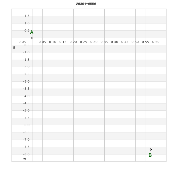
20364-0550 HO 279
20h 36m 24.69s -05° 50' 19.2" P.A. 184.00 sep 7.7 mag 10.64,12.60
| Coord 2000 |
20364-0550 |
|
Discov num |
HO 279 |
|
Comp |
|
|
Coord arcsec 2000 |
20 36 24.69 -05 50 19.2 |
|
| Date first |
1888 |
|
Date last |
2015 |
|
Obs |
12 |
|
| Pa first |
172 |
|
Pa last |
184.3 |
|
P.A. Now (θ) |
184.3° |
|
| Sep first |
6.7 |
|
Sep last |
7.687 |
|
Sep. Now (ρ) |
7.687" |
|
| Mag pri |
10.64 |
|
Mag sec |
12.60 |
|
delta mag (ΔM) |
1.96 |
|
Spectral class |
|
|
| Pri motion ra |
+012 |
|
Sec motion ra |
+006 |
|
| Pri motion dec |
-011 |
|
Sec motion dec |
-033 |
|
| Notes |
|
|
rPM=0.68
Nature of this double is uncertain.
OTHER CATALOGS AND DESIGNATIONS
| Constellation |
Aquila |
|
Tycho2 |
5188-02056-1 |
|
Gaia DR2 |
6908304644776773248 |
|
ADS |
14049 |
|
WDS 20364-0550 HO 279 : NOTES
No records found.
REFERENCES
| refcode |
metd |
author |
reference |
| Ho_1883 |
Ma j |
Hough, G.W. |
1883MNRAS..43..371H |
| Ho_1883 |
|
MNRAS 43, 371, 1883 (data also in Ho_1890) |
1890AN....125....1H |
| Ho_1884 |
Ma j |
Hough, G.W. |
1884MNRAS..44..365H |
| Ho_1884 |
|
MNRAS 44, 365, 1884 (data also in Ho_1890) |
1890AN....125....1H |
| Ho_1885 |
Ma j |
Hough, G.W. |
1885MNRAS..45..417H |
| Ho_1885 |
|
MNRAS 45, 417, 1885 (data also in Ho_1890) |
1890AN....125....1H |
| Ho_1886 |
Ma j |
Hough, G.W. |
1886MNRAS..46..393H |
| Ho_1886 |
|
MNRAS 46, 393, 1886 (data also in Ho_1890) |
1890AN....125....1H |
| Ho_1887 |
Ma j |
Hough, G.W. |
1887AN....116..273H |
| Ho_1887 |
|
AN 116, 273, 1887 |
|
| Ho_1890 |
Ma j |
Hough, G.W. |
1890AN....125....1H |
| Ho_1890 |
|
AN 125, 1, 1890 |
|
| Ho_1890b |
Ma j |
Hough, G.W. |
1890AJ......9..177H |
| Ho_1890b |
|
AJ 9, 177, 1890 (some data also in Ho_1890 or Ho_1894b) |
1890AN....125....1H |
| Ho_1894a |
Ma - |
Hough, G.W. |
1894MNRAS..54..251H |
| Ho_1894a |
|
MNRAS 54, 251, 1894 |
|
| Ho_1894b |
Ma j |
Hough, G.W. (HO 304 - 490) |
1894AN....135..281H |
| Ho_1894b |
|
AN 135, 281, 1894 |
|
| Ho_1894c |
Ma - |
Hough, G.W. (measure by Dembowski, H.) |
1894AN....135..281H |
| Ho_1894c |
|
AN 135, 281, 1894 |
|
| Ho_1899a |
Ma j |
Hough, G.W. |
1899AN....149..65H |
| Ho_1899a |
|
AN 149, 65, 1899 |
|
| Ho_1899b |
Ma - |
Hough, G.W. (measure by Burnham, S.W.) |
1899AN....149..65H |
| Ho_1899b |
|
AN 149, 65, 1899 |
|
| Ho_1907 |
Ma - |
Hough, G.W. |
1907PFAO....3c...1D |
| Ho_1907 |
|
Pub. Univ. Penn. 3, Pt. 3, 1907 (measures sent to Doolittle) |
|
| Ho_1932A |
Ma - |
Hough, G.W. |
1932QB821.A43...... |
| Ho_1932A |
|
cited in ADS, 1932 (unpublished measures sent to Aitken in manuscript by Fox) |
|
WDS HISTORIC DATA
| coord_2000 |
discov_num |
comp |
epoch |
obs |
pa |
sep |
mag_pri |
mag_sec |
spectr |
notes |
coord_arcsec_2000 |
| 20364-0550 |
HO 279 |
|
2000 |
6 |
183 |
7.7 |
10.64 |
12.60 |
|
D |
203624.69-055019.2 |
| 20364-0550 |
HO 279 |
|
2010 |
9 |
182 |
7.3 |
10.64 |
12.60 |
|
|
203624.69-055019.2 |
| 20364-0550 |
HO 279 |
|
2015 |
10 |
184 |
7.7 |
10.64 |
12.60 |
|
|
203624.69-055019.2 |
If you need more information about this double, apply for a
data request form to the WDS.
WDS 20364-0550 HO 279 : VISUAL OBSERVATIONS REPORTS
No records found.
WDS 20364-0550 HO 279 : MEASURES
No records found.
WDS 20364-0550 : VIRTUAL EYEPIECE
Click on the map to see the double of your interest.
Pass over with the mouse cursor to display the catalog designation.
|
|
WDS 20364-0550 : ALADIN DSS IMAGE @ 20h 36m 24.69s -05° 50' 19.2"
WDS 20364-0550 HO 279 : NEIGHBORHOODS
|
|
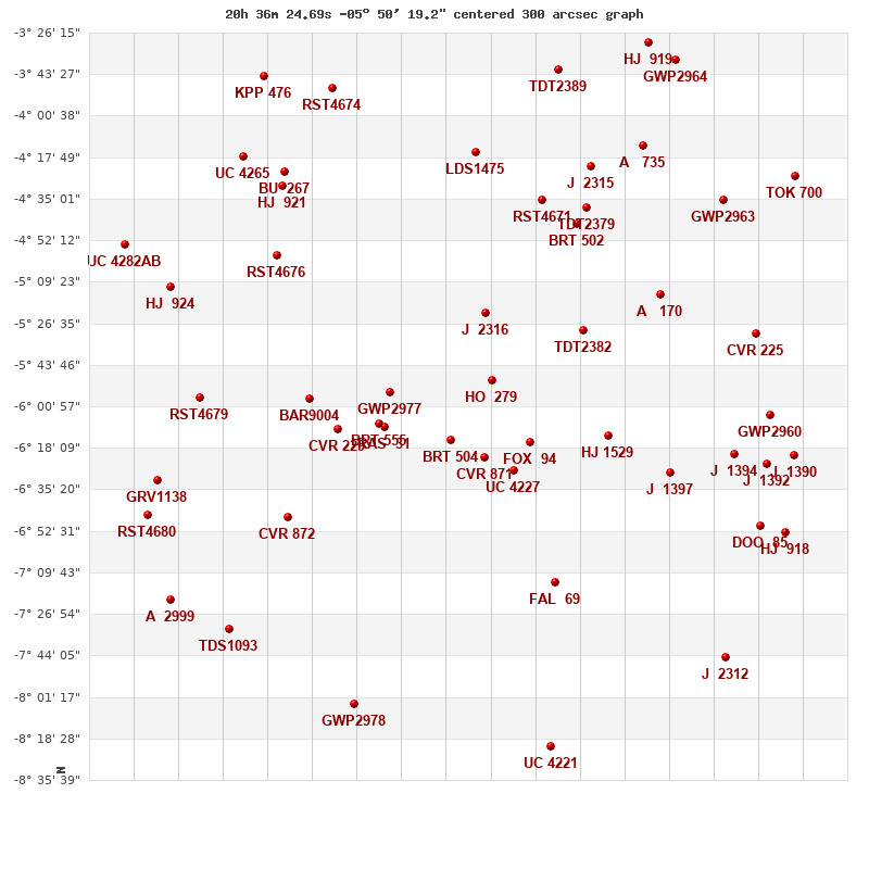
Click on the map to see the double of your interest.
Pass over with the mouse cursor to display the catalog designation.
|
| Show |
name |
coord_2000 |
discov# |
comp |
pa |
sep |
dist(') |
| Show |
|
20364-0550 |
HO 279 |
|
184 |
7.7 |
|
| Show |
|
20372-0523 |
J 2316 |
|
54 |
12.7 |
29 |
| Show |
|
20375-0614 |
BRT 504 |
|
329 |
3.9 |
30 |
| Show |
|
20354-0615 |
FOX 94 |
|
240 |
2.5 |
30 |
| Show |
|
20366-0622 |
CVR 871 |
|
295 |
23.9 |
32 |
| Show |
|
20358-0628 |
UC 4227 |
|
283 |
36.9 |
39 |
| Show |
|
20390-0555 |
GWP2977 |
|
142 |
108.2 |
40 |
| Show |
|
20341-0530 |
TDT2382 |
|
249 |
1.2 |
41 |
| Show |
|
20392-0609 |
RAS 31 |
|
142 |
0.5 |
46 |
| Show |
|
20393-0609 |
BRT 555 |
|
266 |
2.9 |
47 |
| Show |
|
20334-0613 |
HJ 1529 |
|
110 |
37.0 |
51 |
| Show |
|
20404-0610 |
CVR 229 |
|
73 |
35.1 |
63 |
| Show |
|
20411-0558 |
BAR9004 |
|
266 |
3.2 |
71 |
| Show |
|
20343-0445 |
BRT 502 |
|
120 |
3.3 |
73 |
| Show |
|
20321-0515 |
A 170 |
|
218 |
1.7 |
74 |
| Show |
|
20351-0436 |
RST4671 |
|
48 |
0.7 |
78 |
| Show |
|
20318-0629 |
J 1397 |
|
347 |
3.7 |
79 |
| Show |
|
20340-0438 |
TDT2379 |
|
180 |
3.9 |
81 |
| Show |
|
20348-0714 |
FAL 69 |
|
53 |
14.2 |
88 |
| Show |
|
20369-0416 |
LDS1475 |
|
259 |
21.2 |
95 |
| Show |
|
20417-0646 |
CVR 872 |
|
20 |
20.3 |
97 |
| Show |
|
20345-0421 |
J 2315 |
|
319 |
6.5 |
97 |
| Show |
|
20419-0458 |
RST4676 |
|
188 |
0.3 |
98 |
| Show |
|
20302-0621 |
J 1394 |
|
147 |
10.9 |
98 |
| Show |
|
20296-0531 |
CVR 225 |
|
85 |
36.0 |
104 |
| Show |
|
20293-0605 |
GWP2960 |
|
285 |
262.4 |
108 |
| Show |
|
20293-0624 |
J 1392 |
|
317 |
3.4 |
111 |
| Show |
|
20439-0557 |
RST4679 |
|
356 |
0.3 |
112 |
| Show |
|
20325-0413 |
A 735 |
|
271 |
4.5 |
114 |
| Show |
|
20418-0430 |
HJ 921 |
|
220 |
9.4 |
114 |
| Show |
|
20305-0436 |
GWP2963 |
|
324 |
29.1 |
116 |
| Show |
|
20417-0424 |
BU 267 |
|
237 |
1.9 |
118 |
| Show |
|
20296-0650 |
DOO 85 |
|
246 |
3.7 |
120 |
| Show |
|
20286-0622 |
J 1390 |
|
348 |
8.1 |
120 |
| Show |
|
20289-0652 |
HJ 918 |
|
326 |
7.7 |
129 |
| Show |
|
20447-0511 |
HJ 924 |
|
85 |
8.1 |
130 |
| Show |
|
20347-0341 |
TDT2389 |
|
184 |
0.6 |
132 |
| Show |
|
20428-0418 |
UC 4265 |
|
32 |
50.1 |
134 |
| Show |
|
20440-0631 |
GRV1138 |
|
50 |
33.2 |
135 |
| Show |
|
20405-0349 |
RST4674 |
|
118 |
5.1 |
136 |
| Show |
|
20453-0646 |
RST4680 |
|
235 |
0.1 |
143 |
| Show |
|
20399-0804 |
GWP2978 |
|
153 |
9.0 |
144 |
| Show |
|
20286-0426 |
TOK 700 |
|
235 |
0.1 |
144 |
| Show |
|
20432-0733 |
TDS1093 |
|
33 |
0.9 |
144 |
| Show |
|
20305-0745 |
J 2312 |
|
123 |
5.4 |
146 |
| Show |
|
20317-0337 |
GWP2964 |
|
162 |
24.1 |
151 |
| Show |
|
20458-0454 |
UC 4282 |
AB |
209 |
41.1 |
152 |
| Show |
|
20324-0330 |
HJ 919 |
|
219 |
24.6 |
153 |
| Show |
|
20447-0721 |
A 2999 |
|
221 |
2.1 |
153 |
| Show |
|
20349-0822 |
UC 4221 |
|
312 |
17.5 |
154 |
| Show |
|
20423-0344 |
KPP 476 |
|
141 |
3.9 |
154 |
|
|
WDS 20364-0550 : COMPONENTS
20364-0550 A
| Componente originario normalizzato |
AB |
|
Coord arcsec 2000 |
203624.69-055019.2 |
|
Mag |
10.64 |
|
PmRA |
12.00 |
|
| PmDE |
-11.0 |
|
Tycho2 |
5188-02056-1 |
|
ADS |
14049 |
|
DM |
BD-06 5530 |
|
| Tycho2 |
5188-02056-1 |
|
Pflag |
|
|
RAmdeg |
309.10287687 |
|
DEmdeg |
-5.83867526 |
|
| PmRA |
13.0 |
|
PmDE |
-12.7 |
|
E RAmdeg |
23 |
|
E DEmdeg |
30 |
|
| E pmRA |
1.9 |
|
E pmDE |
1.9 |
|
EpRAm |
1990.06 |
|
EpDEm |
1988.73 |
|
| Num |
3 |
|
Q RAmdeg |
0.6 |
|
Q DEmdeg |
0.8 |
|
Q pmRA |
0.6 |
|
| Q pmDE |
0.8 |
|
BTmag |
11.187 |
|
E BTmag |
0.047 |
|
VTmag |
10.641 |
|
| E VTmag |
0.041 |
|
Prox |
999 |
|
TYC |
T |
|
HIP |
|
|
| CCDM |
|
|
RAdeg |
309.10284639 |
|
DEdeg |
-5.83864417 |
|
EpRA 1990 |
1.57 |
|
| EpDE 1990 |
1.17 |
|
E RAdeg |
22.8 |
|
E DEdeg |
30.0 |
|
Posflg |
|
|
| Corr |
-0.3 |
|
20364-0550 B
| Componente originario normalizzato |
AB |
|
Coord arcsec 2000 |
203624.65-055026.9 |
|
Mag |
12.6 |
|
PmRA |
6.00 |
|
| PmDE |
-33.0 |
|
Calc delta mag |
1.96 |
|
Calc coord |
yes |
|