18412+2505 SLE 501
18h 41m 11.13s +25° 04' 41.9" P.A. 314.00 sep 19.3 mag 11.49,12.60
| Coord 2000 |
18412+2505 |
|
Discov num |
SLE 501 |
|
Comp |
|
|
Coord arcsec 2000 |
18 41 11.13 +25 04 41.9 |
|
| Date first |
1982 |
|
Date last |
2015 |
|
Obs |
9 |
|
| Pa first |
309 |
|
Pa last |
314.1 |
|
P.A. Now (θ) |
314.1° |
|
| Sep first |
19.8 |
|
Sep last |
19.331 |
|
Sep. Now (ρ) |
19.331" |
|
| Mag pri |
11.49 |
|
Mag sec |
12.60 |
|
delta mag (ΔM) |
1.11 |
|
Spectral class |
|
|
| Pri motion ra |
-033 |
|
Sec motion ra |
-011 |
|
| Pri motion dec |
-016 |
|
Sec motion dec |
-006 |
|
| Notes |
|
|
rPM=0.659
Nature of this double is uncertain.
OTHER CATALOGS AND DESIGNATIONS
| Constellation |
Hercules |
|
Tycho2 |
2111-00526-1 |
|
Gaia DR2 |
4536147581037121408 |
|
HD |
336746 |
|
WDS 18412+2505 SLE 501 : NOTES
No records found.
REFERENCES
| refcode |
metd |
author |
reference |
| Sle1966 |
Mc j |
Soulie, G. |
1966JO.....49..359S |
| Sle1966 |
+Pa |
J. Obs. 49, 359, 1966 |
|
| Sle1983 |
Pa - |
Soulie, G. |
1983A&AS...54..281S |
| Sle1983 |
|
A&AS 54, 281, 1983 |
|
| Sle1984 |
Pa - |
Soulie, G. |
1984A&AS...56..351S |
| Sle1984 |
|
A&AS 56, 351, 1984 |
|
| Sle1985 |
Pa - |
Soulie, G. |
1985A&AS...61...17S |
| Sle1985 |
|
A&AS 61, 17, 1985 |
|
| Sle1986a |
Pa - |
Soulie, G. |
. |
| Sle1986a |
|
Bull. Inf. Cent. Donnes Stell. #30, 91, 1986 |
|
| Sle1986b |
Pa - |
Soulie, G. |
. |
| Sle1986b |
|
Bull. Inf. Cent. Donnes Stell. #30, 103, 1986 |
|
| Sle2003 |
C j |
Soulie, G. |
2003O&T....56...10S |
| Sle2003 |
|
Obs. et Travaux 56, 10, 2003 |
|
| Sle2006 |
Pa - |
Soulie, G. |
2006O&T....62...26S |
| Sle2006 |
|
Obs. et Travaux 62, 26, 2006 |
|
| Sle2006b |
Pa j |
Soulie, G. |
2006O&T....63...15S |
| Sle2006b |
|
Obs. et Travaux 63, 15, 2006 |
|
| Sle2007 |
C j |
Soulie, G. |
2007O&T....65...34S |
| Sle2007 |
|
Obs. et Travaux 65, 34, 2007 |
|
WDS HISTORIC DATA
| coord_2000 |
discov_num |
comp |
epoch |
obs |
pa |
sep |
mag_pri |
mag_sec |
spectr |
notes |
coord_arcsec_2000 |
| 18412+2505 |
SLE 501 |
|
2000 |
2 |
313 |
19.6 |
11.49 |
12.60 |
|
D |
184111.13+250441.9 |
| 18412+2505 |
SLE 501 |
|
2002 |
3 |
313 |
19.5 |
11.49 |
12.60 |
|
D |
184111.13+250441.9 |
| 18412+2505 |
SLE 501 |
|
2010 |
4 |
314 |
19.4 |
11.49 |
12.60 |
|
|
184111.13+250441.9 |
| 18412+2505 |
SLE 501 |
|
2015 |
5 |
314 |
19.3 |
11.49 |
12.60 |
|
|
184111.13+250441.9 |
If you need more information about this double, apply for a
data request form to the WDS.
WDS 18412+2505 SLE 501 : VISUAL OBSERVATIONS REPORTS
No records found.
WDS 18412+2505 SLE 501 : MEASURES
No records found.
WDS 18412+2505 : VIRTUAL EYEPIECE

Click on the map to see the double of your interest.
Pass over with the mouse cursor to display the catalog designation.
|
|
WDS 18412+2505 : ALADIN DSS IMAGE @ 18h 41m 11.13s +25° 04' 41.9"
WDS 18412+2505 SLE 501 : NEIGHBORHOODS
|
|
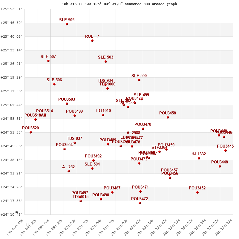
Click on the map to see the double of your interest.
Pass over with the mouse cursor to display the catalog designation.
|
| Show |
name |
coord_2000 |
discov# |
comp |
pa |
sep |
dist(') |
| Show |
|
18412+2505 |
SLE 501 |
|
314 |
19.3 |
|
| Show |
|
18413+2506 |
SLE 502 |
|
94 |
6.2 |
3 |
| Show |
|
18409+2506 |
POU3474 |
|
94 |
6.2 |
4 |
| Show |
|
18407+2509 |
SLE 499 |
|
347 |
31.0 |
8 |
| Show |
|
18421+2501 |
TDT1010 |
|
323 |
1.9 |
13 |
| Show |
|
18407+2454 |
POU3470 |
|
149 |
11.5 |
14 |
| Show |
|
18419+2514 |
TDT1006 |
|
13 |
1.8 |
14 |
| Show |
|
18408+2518 |
SLE 500 |
|
179 |
18.1 |
15 |
| Show |
|
18410+2450 |
A 2988 |
|
210 |
0.1 |
16 |
| Show |
|
18420+2516 |
TDS 934 |
|
203 |
1.3 |
16 |
| Show |
|
18411+2447 |
LDS6330 |
|
5 |
4.5 |
18 |
| Show |
|
18409+2447 |
POU3477 |
|
147 |
14.0 |
19 |
| Show |
|
18398+2459 |
POU3458 |
|
21 |
7.2 |
20 |
| Show |
|
18410+2445 |
POU3478 |
|
115 |
9.8 |
20 |
| Show |
|
18414+2445 |
POU3484 |
|
61 |
9.9 |
21 |
| Show |
|
18419+2446 |
POU3489 |
|
165 |
10.2 |
22 |
| Show |
|
18420+2528 |
SLE 503 |
|
130 |
9.8 |
26 |
| Show |
|
18431+2500 |
POU3499 |
|
295 |
12.4 |
26 |
| Show |
|
18405+2440 |
POU3468 |
|
64 |
11.1 |
27 |
| Show |
|
18401+2442 |
STF2364 |
|
174 |
10.6 |
28 |
| Show |
|
18404+2439 |
POU3467 |
|
132 |
9.6 |
28 |
| Show |
|
18398+2443 |
POU3459 |
|
72 |
9.7 |
29 |
| Show |
|
18408+2437 |
POU3473 |
|
132 |
7.7 |
29 |
| Show |
|
18433+2506 |
POU3503 |
|
95 |
6.3 |
30 |
| Show |
|
18431+2447 |
TDS 937 |
|
44 |
1.7 |
32 |
| Show |
|
18424+2438 |
POU3492 |
|
94 |
8.4 |
32 |
| Show |
|
18424+2434 |
SLE 504 |
|
13 |
20.4 |
36 |
| Show |
|
18438+2516 |
SLE 506 |
|
143 |
13.0 |
38 |
| Show |
|
18434+2439 |
POU3504 |
|
212 |
6.3 |
38 |
| Show |
|
18425+2537 |
ROE 7 |
|
198 |
9.8 |
38 |
| Show |
|
18397+2430 |
POU3457 |
|
322 |
6.4 |
40 |
| Show |
|
18441+2500 |
POU3514 |
|
273 |
6.8 |
41 |
| Show |
|
18397+2429 |
POU3456 |
|
190 |
21.3 |
41 |
| Show |
|
18387+2439 |
HJ 1332 |
|
232 |
27.8 |
43 |
| Show |
|
18407+2423 |
POU3471 |
|
164 |
10.0 |
43 |
| Show |
|
18432+2433 |
A 252 |
|
288 |
1.6 |
44 |
| Show |
|
18417+2422 |
POU3487 |
|
152 |
11.0 |
44 |
| Show |
|
18440+2528 |
SLE 507 |
|
70 |
18.3 |
45 |
| Show |
|
18444+2458 |
POU3518 |
AB |
350 |
12.5 |
45 |
| Show |
|
18444+2458 |
POU3519 |
AC |
303 |
12.8 |
45 |
| Show |
|
18380+2450 |
POU3449 |
|
226 |
5.0 |
46 |
| Show |
|
18421+2419 |
POU3490 |
|
259 |
3.7 |
49 |
| Show |
|
18378+2450 |
POU3446 |
|
126 |
13.5 |
49 |
| Show |
|
18446+2452 |
POU3520 |
|
304 |
9.3 |
49 |
| Show |
|
18408+2417 |
POU3472 |
|
38 |
6.3 |
49 |
| Show |
|
18433+2546 |
SLE 505 |
|
145 |
12.7 |
51 |
| Show |
|
18429+2420 |
POU3497 |
|
207 |
11.1 |
51 |
| Show |
|
18377+2443 |
POU3445 |
|
254 |
11.2 |
52 |
| Show |
|
18429+2418 |
TDT1015 |
|
214 |
0.4 |
53 |
| Show |
|
18379+2435 |
POU3448 |
|
31 |
19.0 |
54 |
| Show |
|
18387+2422 |
POU3452 |
|
139 |
16.1 |
55 |
|
|
WDS 18412+2505 : COMPONENTS
18412+2505 A
| Componente originario normalizzato |
AB |
|
Coord arcsec 2000 |
184111.13+250441.9 |
|
Mag |
11.49 |
|
PmRA |
-33.00 |
|
| PmDE |
-16.0 |
|
Tycho2 |
2111-00526-1 |
|
HD |
336746 |
|
| Tycho2 |
2111-00526-1 |
|
Pflag |
|
|
RAmdeg |
280.29637692 |
|
DEmdeg |
25.07832077 |
|
| PmRA |
-32.7 |
|
PmDE |
-15.9 |
|
E RAmdeg |
54 |
|
E DEmdeg |
46 |
|
| E pmRA |
1.7 |
|
E pmDE |
1.7 |
|
EpRAm |
1979.15 |
|
EpDEm |
1982.56 |
|
| Num |
4 |
|
Q RAmdeg |
0.7 |
|
Q DEmdeg |
0.3 |
|
Q pmRA |
0.7 |
|
| Q pmDE |
0.4 |
|
BTmag |
12.194 |
|
E BTmag |
0.115 |
|
VTmag |
11.492 |
|
| E VTmag |
0.083 |
|
Prox |
999 |
|
TYC |
|
|
HIP |
|
|
| CCDM |
|
|
RAdeg |
280.29646139 |
|
DEdeg |
25.07835778 |
|
EpRA 1990 |
1.54 |
|
| EpDE 1990 |
1.67 |
|
E RAdeg |
57.5 |
|
E DEdeg |
48.0 |
|
Posflg |
|
|
| Corr |
-0.1 |
|
18412+2505 B
| Componente originario normalizzato |
AB |
|
Coord arcsec 2000 |
184110.20+250455.4 |
|
Mag |
12.6 |
|
PmRA |
-11.00 |
|
| PmDE |
-6.0 |
|
Calc delta mag |
1.11 |
|
Calc coord |
yes |
|