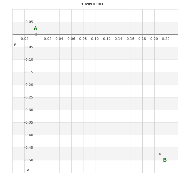
18289+0943 TDT 900
18h 28m 55.69s +09° 43' 29.7" P.A. 204.00 sep 0.5 mag 11.13,11.22
| Coord 2000 |
18289+0943 |
|
Discov num |
TDT 900 |
|
Comp |
|
|
Coord arcsec 2000 |
18 28 55.69 +09 43 29.7 |
|
| Date first |
1991 |
|
Date last |
1991 |
|
Obs |
1 |
|
| Pa first |
204 |
|
Pa last |
204.2 |
|
P.A. Now (θ) |
204.2° |
|
| Sep first |
0.5 |
|
Sep last |
0.52 |
|
Sep. Now (ρ) |
0.52" |
|
| Mag pri |
11.13 |
|
Mag sec |
11.22 |
|
delta mag (ΔM) |
0.09 |
|
Spectral class |
|
|
| Pri motion ra |
-003 |
|
Sec motion ra |
-003 |
|
| Pri motion dec |
-012 |
|
Sec motion dec |
-012 |
|
| Notes |
|
|
Nature of this double is uncertain.
OTHER CATALOGS AND DESIGNATIONS
| Constellation |
Ophiuchus |
|
Tycho2 |
1027-01975-1 |
|
Gaia DR2 |
4480198794429645568 |
|
WDS 18289+0943 TDT 900 : NOTES
No records found.
REFERENCES
No records found.
WDS HISTORIC DATA
| coord_2000 |
discov_num |
comp |
epoch |
obs |
pa |
sep |
mag_pri |
mag_sec |
spectr |
notes |
coord_arcsec_2000 |
| 18289+0943 |
TDT 900 |
|
1991 |
1 |
204 |
0.5 |
11.13 |
11.22 |
|
|
182855.69+094329.7 |
If you need more information about this double, apply for a
data request form to the WDS.
WDS 18289+0943 TDT 900 : VISUAL OBSERVATIONS REPORTS
No records found.
WDS 18289+0943 TDT 900 : MEASURES
No records found.
WDS 18289+0943 : VIRTUAL EYEPIECE
Click on the map to see the double of your interest.
Pass over with the mouse cursor to display the catalog designation.
|
|
WDS 18289+0943 : ALADIN DSS IMAGE @ 18h 28m 55.69s +09° 43' 29.7"
WDS 18289+0943 TDT 900 : NEIGHBORHOODS
|
|
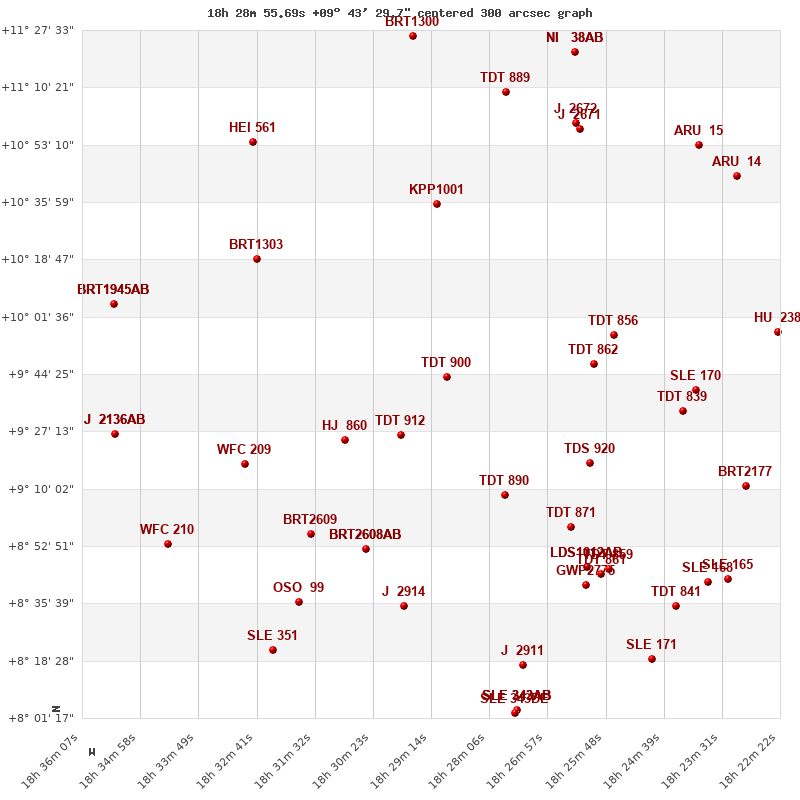
Click on the map to see the double of your interest.
Pass over with the mouse cursor to display the catalog designation.
|
| Show |
name |
coord_2000 |
discov# |
comp |
pa |
sep |
dist(') |
| Show |
|
18289+0943 |
TDT 900 |
|
204 |
0.5 |
1 |
| Show |
|
18298+0926 |
TDT 912 |
|
285 |
0.6 |
22 |
| Show |
|
18310+0924 |
HJ 860 |
|
272 |
22.8 |
36 |
| Show |
|
18278+0908 |
TDT 890 |
|
|
1.4 |
40 |
| Show |
|
18260+0948 |
TDT 862 |
|
298 |
1.1 |
43 |
| Show |
|
18261+0918 |
TDS 920 |
|
58 |
2.0 |
50 |
| Show |
|
18256+0956 |
TDT 856 |
|
43 |
1.1 |
51 |
| Show |
|
18291+1035 |
KPP1001 |
|
11 |
8.1 |
52 |
| Show |
|
18305+0852 |
BRT2608 |
AB |
40 |
4.8 |
57 |
| Show |
|
18305+0852 |
WLY 10 |
AC |
80 |
12.2 |
57 |
| Show |
|
18265+0859 |
TDT 871 |
|
214 |
0.6 |
58 |
| Show |
|
18330+0900 |
BRT2609 |
|
116 |
5.2 |
62 |
| Show |
|
18329+0917 |
WFC 209 |
|
337 |
7.2 |
65 |
| Show |
|
18326+1019 |
BRT1303 |
|
295 |
7.4 |
66 |
| Show |
|
18243+0933 |
TDT 839 |
|
24 |
0.7 |
70 |
| Show |
|
18298+0835 |
J 2914 |
|
176 |
5.0 |
70 |
| Show |
|
18262+0847 |
LDS1012 |
AB |
163 |
608.5 |
71 |
| Show |
|
18262+0847 |
LLO 15 |
AC |
221 |
10.2 |
71 |
| Show |
|
18240+0940 |
SLE 170 |
|
166 |
16.3 |
73 |
| Show |
|
18262+0841 |
GWP2775 |
|
87 |
15.8 |
75 |
| Show |
|
18259+0844 |
TDT 861 |
|
277 |
2.1 |
75 |
| Show |
|
18257+0846 |
TDT 859 |
|
285 |
0.5 |
75 |
| Show |
|
18319+0836 |
OSO 99 |
|
82 |
9.0 |
81 |
| Show |
|
18264+1057 |
J 2671 |
|
334 |
7.0 |
84 |
| Show |
|
18265+1100 |
J 2672 |
|
329 |
7.3 |
85 |
| Show |
|
18278+1109 |
TDT 889 |
|
139 |
2.0 |
88 |
| Show |
|
18273+0820 |
J 2911 |
|
138 |
2.6 |
90 |
| Show |
|
18328+1054 |
HEI 561 |
|
190 |
2.4 |
91 |
| Show |
|
18230+0911 |
BRT2177 |
|
333 |
4.8 |
94 |
| Show |
|
18344+0853 |
WFC 210 |
|
50 |
7.4 |
96 |
| Show |
|
18244+0835 |
TDT 841 |
|
116 |
0.5 |
96 |
| Show |
|
18324+0822 |
SLE 351 |
|
279 |
9.0 |
97 |
| Show |
|
18224+0957 |
HU 238 |
|
162 |
0.9 |
98 |
| Show |
|
18238+0842 |
SLE 168 |
|
261 |
11.3 |
98 |
| Show |
|
18355+0927 |
J 2136 |
AB |
131 |
2.4 |
99 |
| Show |
|
18355+0927 |
J 2136 |
AC |
251 |
9.7 |
99 |
| Show |
|
18355+0927 |
J 2136 |
BC |
265 |
12.2 |
99 |
| Show |
|
18355+1005 |
BRT1945 |
AB |
358 |
5.8 |
100 |
| Show |
|
18355+1005 |
BRT1945 |
AC |
108 |
8.3 |
100 |
| Show |
|
18355+1005 |
J 2137 |
CD |
156 |
11.8 |
100 |
| Show |
|
18240+1053 |
ARU 15 |
|
215 |
0.3 |
102 |
| Show |
|
18234+0843 |
SLE 165 |
|
177 |
12.4 |
102 |
| Show |
|
18276+0804 |
SLE 343 |
AB |
343 |
11.8 |
102 |
| Show |
|
18276+0804 |
SLE 343 |
AC |
104 |
66.0 |
102 |
| Show |
|
18276+0804 |
SLE 343 |
AD |
144 |
62.4 |
102 |
| Show |
|
18276+0804 |
SLE 343 |
DE |
149 |
11.3 |
103 |
| Show |
|
18296+1126 |
BRT1300 |
|
262 |
4.3 |
103 |
| Show |
|
18249+0819 |
SLE 171 |
|
84 |
23.9 |
104 |
| Show |
|
18232+1044 |
ARU 14 |
|
151 |
0.4 |
104 |
| Show |
|
18264+1121 |
NI 38 |
AB |
197 |
8.2 |
105 |
| Show |
|
18264+1121 |
CRC 29 |
AC |
10 |
4.2 |
105 |
|
|
WDS 18289+0943 : COMPONENTS
18289+0943 A
| Componente originario normalizzato |
AB |
|
Coord arcsec 2000 |
182855.69+094329.7 |
|
Mag |
11.13 |
|
PmRA |
-3.00 |
|
| PmDE |
-12.0 |
|
Tycho2 |
1027-01975-1 |
|
| Tycho2 |
1027-01975-1 |
|
Pflag |
|
|
RAmdeg |
277.23202106 |
|
DEmdeg |
9.72484294 |
|
| PmRA |
-2.7 |
|
PmDE |
-12.4 |
|
E RAmdeg |
24 |
|
E DEmdeg |
28 |
|
| E pmRA |
1.9 |
|
E pmDE |
1.8 |
|
EpRAm |
1988.08 |
|
EpDEm |
1986.87 |
|
| Num |
5 |
|
Q RAmdeg |
0.7 |
|
Q DEmdeg |
1.1 |
|
Q pmRA |
0.7 |
|
| Q pmDE |
1.1 |
|
BTmag |
11.272 |
|
E BTmag |
0.058 |
|
VTmag |
10.563 |
|
| E VTmag |
0.043 |
|
Prox |
999 |
|
TYC |
T |
|
HIP |
|
|
| CCDM |
|
|
RAdeg |
277.23203083 |
|
DEdeg |
9.72487917 |
|
EpRA 1990 |
1.84 |
|
| EpDE 1990 |
1.80 |
|
E RAdeg |
27.6 |
|
E DEdeg |
33.7 |
|
Posflg |
|
|
| Corr |
0.0 |
|
18289+0943 B
| Componente originario normalizzato |
AB |
|
Coord arcsec 2000 |
182855.68+094329.2 |
|
Mag |
11.22 |
|
PmRA |
-3.00 |
|
| PmDE |
-12.0 |
|
Calc delta mag |
0.09 |
|
Calc coord |
yes |
|