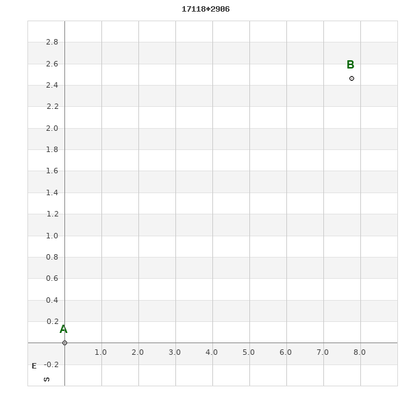
17118+2906 SLE 11
17h 11m 46.73s +29° 05' 42.8" P.A. 286.00 sep 9.2 mag 11.36,12.30
| Coord 2000 |
17118+2906 |
|
Discov num |
SLE 11 |
|
Comp |
|
|
Coord arcsec 2000 |
17 11 46.73 +29 05 42.8 |
|
| Date first |
1901 |
|
Date last |
2019 |
|
Obs |
15 |
|
| Pa first |
279 |
|
Pa last |
285.5 |
|
P.A. Now (θ) |
285.5° |
|
| Sep first |
9.1 |
|
Sep last |
9.21 |
|
Sep. Now (ρ) |
9.21" |
|
| Mag pri |
11.36 |
|
Mag sec |
12.30 |
|
delta mag (ΔM) |
0.94 |
|
Spectral class |
|
|
| Pri motion ra |
-006 |
|
Sec motion ra |
-030 |
|
| Pri motion dec |
-005 |
|
Sec motion dec |
+008 |
|
| Notes |
|
|
rPM=0.879
This double is not physical.
OTHER CATALOGS AND DESIGNATIONS
| Constellation |
Hercules |
|
Tycho2 |
2073-00745-1 |
|
Gaia DR2 |
4575512399408726912 |
|
WDS 17118+2906 SLE 11 : NOTES
No records found.
REFERENCES
| refcode |
metd |
author |
reference |
| Sle1966 |
Mc j |
Soulie, G. |
1966JO.....49..359S |
| Sle1966 |
+Pa |
J. Obs. 49, 359, 1966 |
|
| Sle1983 |
Pa - |
Soulie, G. |
1983A&AS...54..281S |
| Sle1983 |
|
A&AS 54, 281, 1983 |
|
| Sle1984 |
Pa - |
Soulie, G. |
1984A&AS...56..351S |
| Sle1984 |
|
A&AS 56, 351, 1984 |
|
| Sle1985 |
Pa - |
Soulie, G. |
1985A&AS...61...17S |
| Sle1985 |
|
A&AS 61, 17, 1985 |
|
| Sle1986a |
Pa - |
Soulie, G. |
. |
| Sle1986a |
|
Bull. Inf. Cent. Donnes Stell. #30, 91, 1986 |
|
| Sle1986b |
Pa - |
Soulie, G. |
. |
| Sle1986b |
|
Bull. Inf. Cent. Donnes Stell. #30, 103, 1986 |
|
| Sle2003 |
C j |
Soulie, G. |
2003O&T....56...10S |
| Sle2003 |
|
Obs. et Travaux 56, 10, 2003 |
|
| Sle2006 |
Pa - |
Soulie, G. |
2006O&T....62...26S |
| Sle2006 |
|
Obs. et Travaux 62, 26, 2006 |
|
| Sle2006b |
Pa j |
Soulie, G. |
2006O&T....63...15S |
| Sle2006b |
|
Obs. et Travaux 63, 15, 2006 |
|
| Sle2007 |
C j |
Soulie, G. |
2007O&T....65...34S |
| Sle2007 |
|
Obs. et Travaux 65, 34, 2007 |
|
WDS HISTORIC DATA
| coord_2000 |
discov_num |
comp |
epoch |
obs |
pa |
sep |
mag_pri |
mag_sec |
spectr |
notes |
coord_arcsec_2000 |
| 17118+2906 |
SLE 11 |
|
2006 |
7 |
285 |
9.5 |
11.36 |
12.30 |
|
D |
171146.73+290542.8 |
| 17118+2906 |
SLE 11 |
|
2010 |
9 |
285 |
8.4 |
11.36 |
12.30 |
|
|
171146.73+290542.8 |
| 17118+2906 |
SLE 11 |
|
2015 |
10 |
285 |
9.2 |
11.36 |
12.30 |
|
|
171146.73+290542.8 |
| 17118+2906 |
SLE 11 |
|
2019 |
15 |
286 |
9.2 |
11.36 |
12.30 |
|
|
171146.73+290542.8 |
If you need more information about this double, apply for a
data request form to the WDS.
WDS 17118+2906 SLE 11 : VISUAL OBSERVATIONS REPORTS
No records found.
WDS 17118+2906 SLE 11 : MEASURES
No records found.
WDS 17118+2906 : VIRTUAL EYEPIECE
Click on the map to see the double of your interest.
Pass over with the mouse cursor to display the catalog designation.
|
|
WDS 17118+2906 : ALADIN DSS IMAGE @ 17h 11m 46.73s +29° 05' 42.8"
WDS 17118+2906 SLE 11 : NEIGHBORHOODS
|
|
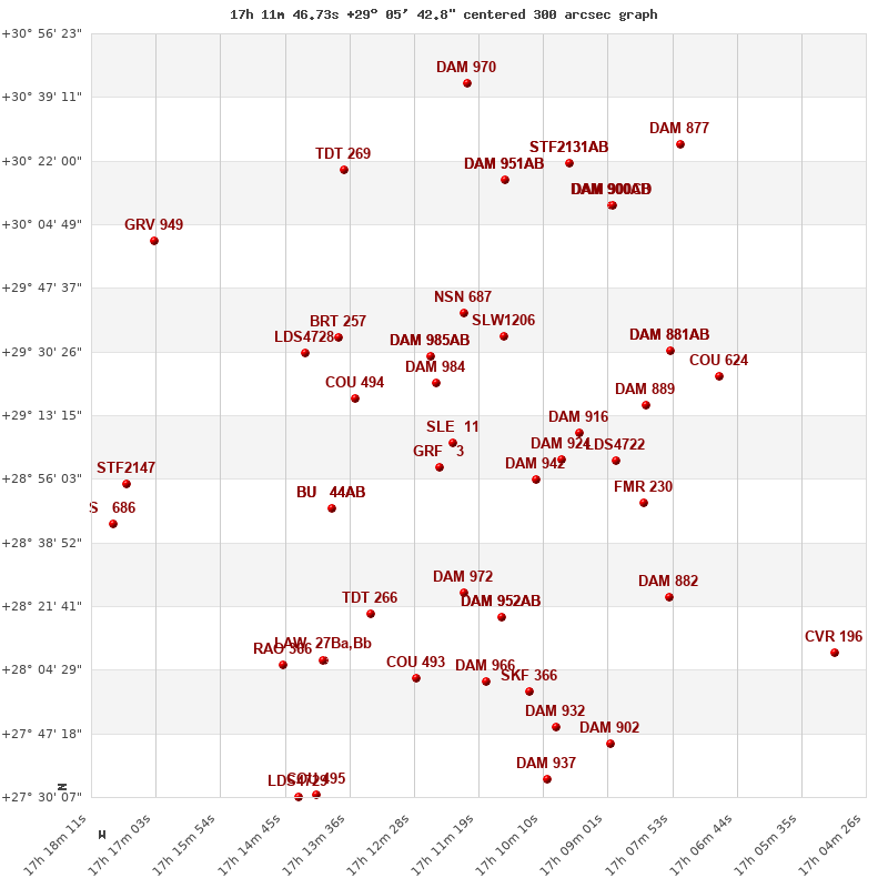
Click on the map to see the double of your interest.
Pass over with the mouse cursor to display the catalog designation.
|
| Show |
name |
coord_2000 |
discov# |
comp |
pa |
sep |
dist(') |
| Show |
|
17118+2906 |
SLE 11 |
|
286 |
9.2 |
|
| Show |
|
17120+2859 |
GRF 3 |
|
186 |
96.5 |
8 |
| Show |
|
17121+2922 |
DAM 984 |
|
331 |
1.8 |
17 |
| Show |
|
17103+2856 |
DAM 942 |
|
279 |
4.9 |
22 |
| Show |
|
17122+2929 |
DAM 985 |
AB |
135 |
1.2 |
25 |
| Show |
|
17122+2929 |
DAM 985 |
AC |
100 |
7.4 |
25 |
| Show |
|
17135+2918 |
COU 494 |
|
354 |
1.6 |
26 |
| Show |
|
17098+2901 |
DAM 924 |
|
134 |
5.1 |
26 |
| Show |
|
17095+2909 |
DAM 916 |
|
344 |
2.6 |
30 |
| Show |
|
17109+2934 |
SLW1206 |
|
303 |
81.6 |
32 |
| Show |
|
17139+2848 |
BU 44 |
AB |
17 |
5.6 |
34 |
| Show |
|
17139+2848 |
BU 44 |
AC |
41 |
42.4 |
34 |
| Show |
|
17116+2941 |
NSN 687 |
|
117 |
11.9 |
36 |
| Show |
|
17088+2900 |
LDS4722 |
|
61 |
19.9 |
39 |
| Show |
|
17135+2935 |
BRT 257 |
|
182 |
5.8 |
39 |
| Show |
|
17116+2825 |
DAM 972 |
|
202 |
3.4 |
41 |
| Show |
|
17145+2931 |
LDS4728 |
|
309 |
2.4 |
43 |
| Show |
|
17084+2916 |
DAM 889 |
|
264 |
2.2 |
47 |
| Show |
|
17084+2850 |
FMR 230 |
|
251 |
3.2 |
48 |
| Show |
|
17109+2819 |
DAM 952 |
AB |
17 |
1.7 |
49 |
| Show |
|
17109+2819 |
DAM 952 |
AC |
292 |
3.8 |
49 |
| Show |
|
17132+2820 |
TDT 266 |
|
343 |
0.8 |
50 |
| Show |
|
17079+2931 |
DAM 881 |
AB |
26 |
2.8 |
57 |
| Show |
|
17079+2931 |
DAM 881 |
AC |
306 |
5.1 |
57 |
| Show |
|
17125+2802 |
COU 493 |
|
56 |
0.3 |
65 |
| Show |
|
17071+2923 |
COU 624 |
|
274 |
3.5 |
65 |
| Show |
|
17112+2801 |
DAM 966 |
|
274 |
3.2 |
65 |
| Show |
|
17079+2824 |
DAM 882 |
|
263 |
10.6 |
66 |
| Show |
|
17141+2807 |
LAW 27 |
Ba,Bb |
259 |
0.1 |
66 |
| Show |
|
17141+2807 |
LAW 27 |
AB |
259 |
7.3 |
66 |
| Show |
|
17104+2759 |
SKF 366 |
|
129 |
48.1 |
70 |
| Show |
|
17148+2806 |
RAO 366 |
|
1 |
0.6 |
72 |
| Show |
|
17109+3017 |
DAM 951 |
AB |
198 |
3.7 |
73 |
| Show |
|
17109+3017 |
DAM 951 |
AC |
102 |
10.5 |
73 |
| Show |
|
17090+3010 |
DAM 900 |
AB |
270 |
5.8 |
74 |
| Show |
|
17090+3010 |
DAM 900 |
AC |
255 |
20.6 |
74 |
| Show |
|
17090+3010 |
DAM 900 |
CD |
150 |
1.0 |
75 |
| Show |
|
17176+2855 |
STF2147 |
|
93 |
6.5 |
77 |
| Show |
|
17137+3020 |
TDT 269 |
|
12 |
0.6 |
79 |
| Show |
|
17097+3021 |
STF2131 |
AB |
178 |
24.3 |
81 |
| Show |
|
17097+3021 |
ARN 46 |
AC |
335 |
140.4 |
81 |
| Show |
|
17100+2749 |
DAM 932 |
|
46 |
4.5 |
81 |
| Show |
|
17178+2844 |
S 686 |
|
4 |
50.0 |
83 |
| Show |
|
17170+3000 |
GRV 949 |
|
277 |
10.6 |
89 |
| Show |
|
17090+2744 |
DAM 902 |
|
228 |
5.5 |
90 |
| Show |
|
17101+2735 |
DAM 937 |
|
200 |
3.4 |
94 |
| Show |
|
17077+3026 |
DAM 877 |
|
138 |
2.7 |
97 |
| Show |
|
17115+3043 |
DAM 970 |
|
298 |
3.8 |
98 |
| Show |
|
17142+2731 |
COU 495 |
|
101 |
0.8 |
101 |
| Show |
|
17145+2731 |
LDS4729 |
|
25 |
108.8 |
103 |
| Show |
|
17050+2809 |
CVR 196 |
|
90 |
27.7 |
106 |
|
|
WDS 17118+2906 : COMPONENTS
17118+2906 A
| Componente originario normalizzato |
AB |
|
Coord arcsec 2000 |
171146.73+290542.8 |
|
Mag |
11.36 |
|
PmRA |
-6.00 |
|
| PmDE |
-5.0 |
|
Tycho2 |
2073-00745-1 |
|
| Tycho2 |
2073-00745-1 |
|
Pflag |
|
|
RAmdeg |
257.94473227 |
|
DEmdeg |
29.09524471 |
|
| PmRA |
-15.3 |
|
PmDE |
-2.2 |
|
E RAmdeg |
48 |
|
E DEmdeg |
49 |
|
| E pmRA |
2.5 |
|
E pmDE |
2.4 |
|
EpRAm |
1987.05 |
|
EpDEm |
1986.80 |
|
| Num |
3 |
|
Q RAmdeg |
1.6 |
|
Q DEmdeg |
1.1 |
|
Q pmRA |
1.6 |
|
| Q pmDE |
1.1 |
|
BTmag |
11.975 |
|
E BTmag |
0.092 |
|
VTmag |
11.362 |
|
| E VTmag |
0.079 |
|
Prox |
999 |
|
TYC |
T |
|
HIP |
|
|
| CCDM |
|
|
RAdeg |
257.94477361 |
|
DEdeg |
29.09524972 |
|
EpRA 1990 |
1.49 |
|
| EpDE 1990 |
1.60 |
|
E RAdeg |
49.3 |
|
E DEdeg |
49.8 |
|
Posflg |
|
|
| Corr |
-0.2 |
|
17118+2906 B
| Componente originario normalizzato |
AB |
|
Coord arcsec 2000 |
171146.14+290545.3 |
|
Mag |
12.3 |
|
PmRA |
-30.00 |
|
| PmDE |
8.0 |
|
Calc delta mag |
0.94 |
|
Calc coord |
yes |
|