14033+0557 HWE 29 AB (HD 122697)
14h 03m 20.86s +05° 57' 28.0" P.A. 235.00 sep 1.4 mag 9.93,9.82 Sp G0
| Coord 2000 |
14033+0557 |
|
Discov num |
HWE 29 |
|
Comp |
AB |
|
Coord arcsec 2000 |
14 03 20.86 +05 57 28.0 |
|
| Date first |
1901 |
|
Date last |
2017 |
|
Obs |
25 |
|
| Pa first |
245 |
|
Pa last |
235.2 |
|
P.A. Now (θ) |
235.2° |
|
| Sep first |
0.9 |
|
Sep last |
1.421 |
|
Sep. Now (ρ) |
1.421" |
|
| Mag pri |
9.93 |
|
Mag sec |
9.82 |
|
delta mag (ΔM) |
0.11 |
|
Spectral class |
G0 (yellow) |
|
| Pri motion ra |
-103 |
|
Sec motion ra |
-103 |
|
| Pri motion dec |
+009 |
|
Sec motion dec |
+009 |
|
| Notes |
|
|
Nature of this double is uncertain.
14033+0557 SYSTEM COMPONENTS
| Show |
name |
SAO |
coord |
wds_name |
last |
obs |
pa |
sep |
mag1 |
mag2 |
d_mag |
orb |
current |
| Show |
HD 122697 |
120257 |
14 03 21 +05 57 28 |
HWE 29 AB |
2017 |
25 |
235 |
1.4 |
9.93 |
9.82 |
0.11 |
|
<=== |
| Show |
|
|
14 03 21 +05 57 28 |
HWE 29 AC |
2015 |
18 |
167 |
16.4 |
9.93 |
12.31 |
2.38 |
|
|
Triple system
3 estimated visually detectable stars in this system
OTHER CATALOGS AND DESIGNATIONS
| Name |
HD 122697 |
|
Constellation |
Virgo |
|
SAO |
120257 |
|
Tycho2 |
0322-00659-1 |
|
| Gaia DR2 |
3672450685963835392 |
|
HD |
122697 |
|
WDS 14033+0557 HWE 29 AB (HD 122697) : NOTES
No records found.
REFERENCES
| refcode |
metd |
author |
reference |
| Hwe1876 |
Ma - |
Howe, H.A. |
1876PCinO...1....1. |
| Hwe1876 |
|
Pub. Cincinnati Obs. #1, 1876 |
|
| Hwe1877 |
Ma - |
Howe, H.A. |
1877PCinO...3....1. |
| Hwe1877 |
|
Pub. Cincinnati Obs. #3, 1877 |
|
| Hwe1878 |
Ma j |
Howe, H.A. |
1878PCinO...4....1. |
| Hwe1878 |
|
Pub. Cincinnati Obs. #4, 1878 |
|
| Hwe1879 |
Ma j |
Howe, H.A. |
1879PCinO...5....1. |
| Hwe1879 |
|
Pub. Cincinnati Obs. #5, 1879 |
|
| Hwe1882 |
Ma - |
Howe, H.A. |
1882PCinO...6....1. |
| Hwe1882 |
|
Pub. Cincinnati Obs. #6, 1882 |
|
| Hwe1906A |
Ma - |
Howe, H.A. |
1906MmRAS..56....1L |
| Hwe1906A |
|
cited by Lewis (MemRAS 56, 1, 1906) |
|
| Hwe1932A |
- |
Howe, H.A. |
1932QB821.A43...... |
| Hwe1932A |
|
cited in ADS (Aitken Double Star Cat.), 1932 |
|
| Hwe9999 |
Ma - |
Howe, H.A. |
................... |
| Hwe9999 |
|
Unpublished, manuscript or reference not found. |
|
WDS HISTORIC DATA
| coord_2000 |
discov_num |
comp |
epoch |
obs |
pa |
sep |
mag_pri |
mag_sec |
spectr |
notes |
coord_arcsec_2000 |
| 14033+0557 |
HWE 29 |
AB |
2005 |
19 |
242 |
1.3 |
9.93 |
9.82 |
G0 |
|
140320.86+055728.0 |
| 14033+0557 |
HWE 29 |
AB |
2010 |
20 |
238 |
1.3 |
9.93 |
9.82 |
G0 |
|
140320.86+055728.0 |
| 14033+0557 |
HWE 29 |
AB |
2012 |
21 |
236 |
1.3 |
9.93 |
9.82 |
G0 |
|
140320.86+055728.0 |
| 14033+0557 |
HWE 29 |
AB |
2015 |
22 |
237 |
1.2 |
9.93 |
9.82 |
G0 |
|
140320.86+055728.0 |
| 14033+0557 |
HWE 29 |
AB |
2017 |
23 |
235 |
1.4 |
9.93 |
9.82 |
G0 |
|
140320.86+055728.0 |
If you need more information about this double, apply for a
data request form to the WDS.
WDS 14033+0557 HWE 29 AB (HD 122697) : VISUAL OBSERVATIONS REPORTS
No records found.
WDS 14033+0557 HWE 29 AB (HD 122697) : MEASURES
No records found.
WDS 14033+0557 (HD 122697) : VIRTUAL EYEPIECE
Click on the map to see the double of your interest.
Pass over with the mouse cursor to display the catalog designation.
|
|
WDS 14033+0557 (HD 122697) : ALADIN DSS IMAGE @ 14h 03m 20.86s +05° 57' 28.0"
WDS 14033+0557 HWE 29 AB (HD 122697) : NEIGHBORHOODS
|
|

Click on the map to see the double of your interest.
Pass over with the mouse cursor to display the catalog designation.
|
| Show |
name |
coord_2000 |
discov# |
comp |
pa |
sep |
dist(') |
| Show |
|
14033+0557 |
HWE 29 |
AB |
235 |
1.4 |
|
| Show |
|
14033+0557 |
HWE 29 |
AC |
167 |
16.4 |
|
| Show |
|
14054+0558 |
STF1801 |
|
73 |
21.6 |
47 |
| Show |
|
14066+0541 |
CVR1563 |
|
157 |
4.3 |
52 |
| Show |
|
14025+0649 |
TDS9077 |
AB |
221 |
0.5 |
53 |
| Show |
|
14025+0649 |
GRV 878 |
AB,C |
285 |
15.6 |
53 |
| Show |
|
14035+0704 |
TDS 735 |
AB |
17 |
0.8 |
67 |
| Show |
|
14036+0451 |
RAO 310 |
|
118 |
0.5 |
67 |
| Show |
|
14077+0616 |
TDS 739 |
|
231 |
2.1 |
67 |
| Show |
|
14056+0500 |
RAO 311 |
|
303 |
0.9 |
68 |
| Show |
|
13590+0531 |
SLW 953 |
AB |
281 |
49.4 |
71 |
| Show |
|
13590+0531 |
UC 2648 |
BC |
107 |
109.7 |
72 |
| Show |
|
13592+0632 |
CLZ 63 |
|
253 |
5.8 |
72 |
| Show |
|
13599+0502 |
GWP2164 |
AB |
280 |
240.9 |
76 |
| Show |
|
14086+0602 |
HJ 2701 |
|
37 |
12.3 |
79 |
| Show |
|
14088+0605 |
CVR1565 |
|
127 |
4.7 |
82 |
| Show |
|
14027+0435 |
GWP2191 |
AB |
192 |
441.6 |
84 |
| Show |
|
14071+0659 |
TDS9100 |
|
110 |
0.9 |
84 |
| Show |
|
13578+0610 |
YSC 51 |
|
143 |
0.2 |
85 |
| Show |
|
14061+0439 |
GWP2218 |
|
247 |
6.5 |
89 |
| Show |
|
13573+0550 |
GOM 27 |
|
292 |
387.0 |
90 |
| Show |
|
14031+0423 |
SLW 957 |
|
266 |
22.4 |
95 |
| Show |
|
13570+0615 |
WIS 240 |
|
296 |
976.9 |
97 |
| Show |
|
14080+0707 |
BRT2156 |
|
60 |
5.4 |
98 |
| Show |
|
14040+0736 |
GIC9019 |
|
177 |
1.1 |
99 |
| Show |
|
14097+0649 |
WIS 250 |
|
125 |
999.9 |
108 |
| Show |
|
13563+0528 |
KPP 742 |
|
82 |
6.5 |
110 |
| Show |
|
14097+0459 |
FOX 71 |
|
181 |
4.1 |
112 |
| Show |
|
14106+0528 |
YSC 52 |
Aa,Ab |
155 |
0.1 |
112 |
| Show |
|
14106+0528 |
HDS1987 |
AB |
258 |
0.9 |
112 |
| Show |
|
14106+0528 |
SKF2658 |
AC |
358 |
5.0 |
112 |
| Show |
|
13562+0634 |
GRV 876 |
|
266 |
18.5 |
112 |
| Show |
|
13563+0517 |
STT 273 |
AB |
113 |
1.0 |
113 |
| Show |
|
13563+0517 |
BU 1438 |
AB,C |
238 |
242.0 |
113 |
| Show |
|
14001+0416 |
HDS1965 |
|
321 |
0.1 |
113 |
| Show |
|
14056+0409 |
SKF1748 |
|
331 |
1.6 |
114 |
| Show |
|
14022+0403 |
GWP2184 |
|
281 |
464.3 |
116 |
| Show |
|
14099+0700 |
CVR1567 |
|
260 |
4.0 |
117 |
| Show |
|
14111+0624 |
BRT2158 |
|
78 |
4.4 |
119 |
| Show |
|
14093+0439 |
BU 1109 |
AB |
311 |
1.8 |
119 |
| Show |
|
14093+0439 |
BU 1109 |
AC |
348 |
55.8 |
119 |
| Show |
|
14110+0525 |
TDS9122 |
|
69 |
0.6 |
120 |
| Show |
|
14088+0428 |
SLW 972 |
|
152 |
166.7 |
122 |
| Show |
|
14092+0723 |
STT 275 |
|
355 |
5.0 |
123 |
| Show |
|
13563+0450 |
CVR1551 |
|
210 |
4.9 |
125 |
| Show |
|
14109+0653 |
GIC 116 |
|
125 |
318.4 |
126 |
| Show |
|
14087+0737 |
WIS 249 |
|
153 |
999.9 |
128 |
| Show |
|
14099+0725 |
LDS4438 |
|
205 |
1.1 |
131 |
| Show |
|
14001+0356 |
UC 188 |
|
138 |
21.6 |
131 |
| Show |
|
14115+0500 |
A 1796 |
|
167 |
3.7 |
135 |
| Show |
|
14065+0805 |
UC 2680 |
|
209 |
14.8 |
137 |
|
|
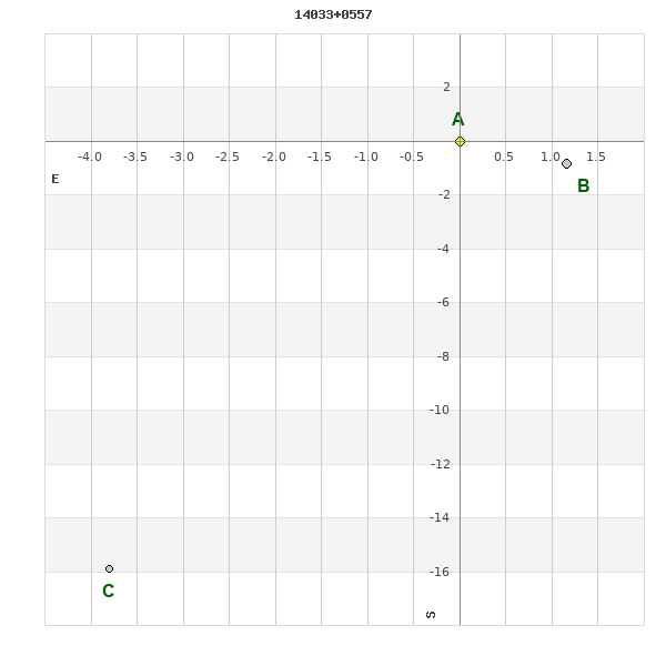
WDS 14033+0557 : COMPONENTS
| |
A |
B |
| B |
pa=235.1°
sep=1.42"
| |
| C |
pa=166.6°
sep=16.36"
| pa=161.8°
sep=15.90"
|
14033+0557 A
| Name |
HD 122697 |
|
Coord arcsec 2000 |
140320.86+055728.0 |
|
Mag |
9.93 |
|
Spectral class |
G0 (yellow) |
|
| PmRA |
-103.00 |
|
PmDE |
9.0 |
|
Tycho2 |
0322-00659-2 |
|
| Tycho2 |
0322-00659-2 |
|
Pflag |
P |
|
RAmdeg |
210.83692587 |
|
DEmdeg |
5.95779127 |
|
| PmRA |
-102.8 |
|
PmDE |
8.7 |
|
E RAmdeg |
12 |
|
E DEmdeg |
19 |
|
| E pmRA |
1.8 |
|
E pmDE |
1.8 |
|
EpRAm |
1991.09 |
|
EpDEm |
1989.85 |
|
| Num |
6 |
|
Q RAmdeg |
1.2 |
|
Q DEmdeg |
1.1 |
|
Q pmRA |
1.3 |
|
| Q pmDE |
1.1 |
|
BTmag |
10.482 |
|
E BTmag |
0.030 |
|
VTmag |
9.931 |
|
| E VTmag |
0.025 |
|
Prox |
13 |
|
TYC |
T |
|
HIP |
|
|
| CCDM |
|
|
RAdeg |
210.83730694 |
|
DEdeg |
5.95786028 |
|
EpRA 1990 |
1.77 |
|
| EpDE 1990 |
1.63 |
|
E RAdeg |
12.1 |
|
E DEdeg |
19.4 |
|
Posflg |
D |
|
| Corr |
0.0 |
|
| Ccdm |
14033+0557 |
|
RComp |
|
|
Comp |
A |
|
Note1 |
|
|
| Note2 |
|
|
Discov num |
|
|
DRAs |
2.86 |
|
DDEs |
27.5 |
|
| R dRAs |
65 |
|
Year |
|
|
Theta |
|
|
Rho |
|
|
| Obs |
3 |
|
Vmag |
10.0 |
|
Sp |
G0 |
|
PmNote |
* |
|
| PmRA |
-121 |
|
PmDE |
4 |
|
Dm number |
+06 2824 |
|
Cat1 |
BD |
|
| Name2 |
+06 1676 |
|
Cat2 |
AGK2/3 |
|
HD |
122697 |
|
M HD |
|
|
| ADS BDS |
A 9091 |
|
M ADS BDS |
|
|
N IDS |
|
|
IDS |
13584N0626A |
|
| HIC |
|
|
14033+0557 B
| Coord arcsec 2000 |
140320.78+055727.2 |
|
Mag |
9.82 |
|
PmRA |
-103.00 |
|
PmDE |
9.0 |
|
| SAO |
120257 |
|
Tycho2 |
0322-00659-1 |
|
HD |
122697 |
|
DM |
BD+06 2824 |
|
| Calc delta mag |
0.11 |
|
Calc coord |
yes |
|
| Tycho2 |
0322-00659-1 |
|
Pflag |
P |
|
RAmdeg |
210.83692587 |
|
DEmdeg |
5.95779127 |
|
| PmRA |
-102.8 |
|
PmDE |
8.7 |
|
E RAmdeg |
12 |
|
E DEmdeg |
19 |
|
| E pmRA |
1.8 |
|
E pmDE |
1.8 |
|
EpRAm |
1991.09 |
|
EpDEm |
1989.85 |
|
| Num |
6 |
|
Q RAmdeg |
1.2 |
|
Q DEmdeg |
1.1 |
|
Q pmRA |
1.3 |
|
| Q pmDE |
1.1 |
|
BTmag |
10.561 |
|
E BTmag |
0.032 |
|
VTmag |
9.820 |
|
| E VTmag |
0.023 |
|
Prox |
13 |
|
TYC |
T |
|
HIP |
|
|
| CCDM |
|
|
RAdeg |
210.83699556 |
|
DEdeg |
5.95766972 |
|
EpRA 1990 |
1.78 |
|
| EpDE 1990 |
1.63 |
|
E RAdeg |
11.9 |
|
E DEdeg |
19.1 |
|
Posflg |
D |
|
| Corr |
0.0 |
|
| SAO |
120257 |
|
DelFlag |
|
|
RA1950 |
|
|
PmRA1950 |
-0.0051 |
|
| DE1950 |
|
|
PmDE1950 |
0.011 |
|
Vmag |
9.2 |
|
SpType |
G0 |
|
| Double code |
|
|
Source |
32 |
|
CatNum |
6587 |
|
DM |
BD+06 2824 |
|
| DMcomp |
|
|
BDsup |
|
|
HD |
122697 |
|
M HD |
0 |
|
| GC |
|
|
RA1950rad |
3.66890637 |
|
DE1950rad |
0.10816742 |
|
PmRA2000 |
-0.0049 |
|
| PmDE2000 |
0.014 |
|
| Ccdm |
14033+0557 |
|
RComp |
|
|
Comp |
B |
|
Note1 |
|
|
| Note2 |
|
|
Discov num |
HWE 29 |
|
DRAs |
|
|
DDEs |
|
|
| R dRAs |
|
|
Year |
1901 |
|
Theta |
063 |
|
Rho |
1.1 |
|
| Obs |
9 |
|
Vmag |
10.1 |
|
Sp |
|
|
PmNote |
|
|
| PmRA |
|
|
PmDE |
|
|
Dm number |
|
|
Cat1 |
|
|
| Name2 |
|
|
Cat2 |
|
|
HD |
|
|
M HD |
|
|
| ADS BDS |
A 9091 |
|
M ADS BDS |
|
|
N IDS |
|
|
IDS |
13584N0626B |
|
| HIC |
|
|
14033+0557 C
| Coord arcsec 2000 |
140321.11+055712.1 |
|
Mag |
12.31 |
|
PmRA |
-44.00 |
|
PmDE |
-6.0 |
|
| Calc delta mag |
2.38 |
|
Calc coord |
yes |
|
| Ccdm |
14033+0557 |
|
RComp |
|
|
Comp |
C |
|
Note1 |
|
|
| Note2 |
|
|
Discov num |
HWE 29 |
|
DRAs |
3.17 |
|
DDEs |
12.5 |
|
| R dRAs |
65 |
|
Year |
1913 |
|
Theta |
184 |
|
Rho |
14.6 |
|
| Obs |
4 |
|
Vmag |
11.5 |
|
Sp |
|
|
PmNote |
|
|
| PmRA |
|
|
PmDE |
|
|
Dm number |
|
|
Cat1 |
|
|
| Name2 |
|
|
Cat2 |
|
|
HD |
|
|
M HD |
|
|
| ADS BDS |
A 9091 |
|
M ADS BDS |
|
|
N IDS |
|
|
IDS |
13584N0626C |
|
| HIC |
|
|