10212-0304 BUG 10
10h 21m 09.69s -03° 04' 19.7" P.A. 164.00 sep 0.2 mag 17.81,17.87 Sp T1+T5
| Coord 2000 |
10212-0304 |
|
Discov num |
BUG 10 |
|
Comp |
|
|
Coord arcsec 2000 |
10 21 09.69 -03 04 19.7 |
|
| Date first |
2004 |
|
Date last |
2013 |
|
Obs |
9 |
|
| Pa first |
245 |
|
Pa last |
163.8 |
|
P.A. Now (θ) |
163.8° |
|
| Sep first |
0.2 |
|
Sep last |
0.153 |
|
Sep. Now (ρ) |
0.153" |
|
| Mag pri |
17.81 |
|
Mag sec |
17.87 |
|
delta mag (ΔM) |
0.06 |
|
Spectral class |
T1+T5 (brown dwarf/brown dwarf) |
|
| Pri motion ra |
|
|
Sec motion ra |
|
|
| Pri motion dec |
|
|
Sec motion dec |
|
|
| Notes |
N
O
K
(See Notes, Orbital solution, K-band or other infrared magnitudes) |
|
Visually invisible, K-band or other infrared star : Summary line gives K-band or other infrared (>1 micron) magnitudes
This double is physical.
OTHER CATALOGS AND DESIGNATIONS
ORBITAL ELEMENTS
| Period (P) | 75y | ± 17 |
Periastron (T) | 82000d (2083.384y) | ± 6000 |
Semi-major axis (a) | 224m | ± 28 |
| Eccentricity (e) | 0.31 | ± 0.07 |
Inclination (i) | 161° | ± 7 |
Longitude of periastron (ω) | 70° | ± 120 |
| Node (Ω) | 260° | ± 100 |
Notes | n | |
Reference | Dup2017 | |
| Equinox | | |
Last observation | 2013 | |
Grade | 5 | (1=Definitive, 9=Indet.) |
| label |
theta |
rho |
| 2000 |
261.0 |
0.184 |
| 2001 |
254.3 |
0.178 |
| 2002 |
247.3 |
0.172 |
| 2003 |
239.8 |
0.167 |
| 2004 |
231.8 |
0.162 |
| 2005 |
223.2 |
0.157 |
| 2006 |
214.2 |
0.153 |
| 2007 |
204.7 |
0.150 |
| 2008 |
194.9 |
0.148 |
| 2009 |
184.9 |
0.147 |
| 2010 |
174.9 |
0.147 |
| 2011 |
165.0 |
0.149 |
| 2012 |
155.5 |
0.153 |
| 2013 |
146.5 |
0.157 |
| 2014 |
138.0 |
0.162 |
| 2015 |
130.1 |
0.168 |
| 2016 |
122.7 |
0.175 |
| 2017 |
115.9 |
0.182 |
| 2018 |
109.6 |
0.188 |
| 2019 |
103.7 |
0.195 |
| 2020 |
98.2 |
0.202 |
| 2021 |
93.1 |
0.209 |
| 2022 |
88.3 |
0.215 |
| 2023 |
83.7 |
0.221 |
| 2024 |
79.4 |
0.227 |
| 2025 |
75.3 |
0.233 |
| 2026 |
71.4 |
0.238 |
| 2027 |
67.7 |
0.243 |
| 2028 |
64.1 |
0.248 |
| 2029 |
60.6 |
0.252 |
| 2030 |
57.3 |
0.256 |
|
|
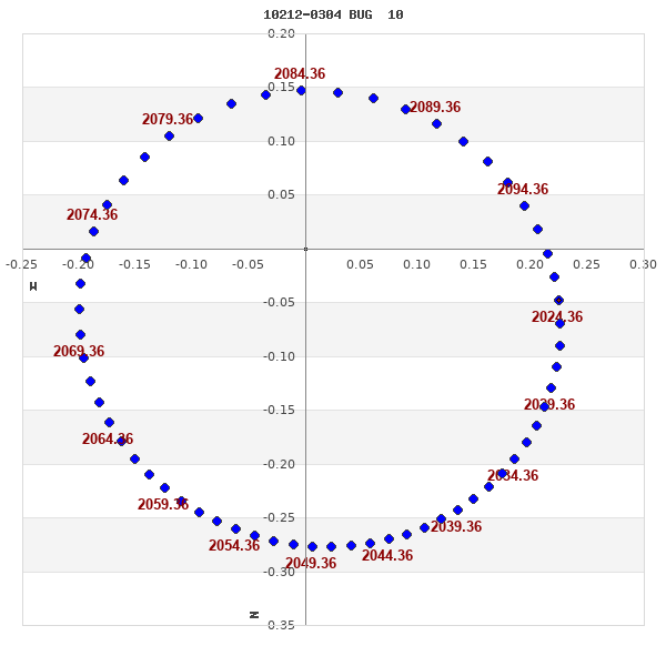
Note: Theta is PA, Rho is Sep. For yearly orbits, data refer to Jan 1st.
|
|
|
|
|
|
|
|
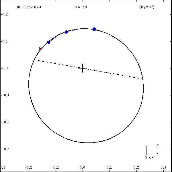
Measures: green=micrometric, blue=interferometric, purple=photographic |
|
WDS 10212-0304 BUG 10 : NOTES
| discov_num |
notes |
refcode |
| BUG 10 |
SDSS J102109.69-030420.1 |
|
|
Estimated spectral types are T1 + T5, effective temperatures 1260 +/- |
|
|
210 and 1130 +/- 190 K. Masses are estimated at 0.025-0.076 and |
|
|
0.021-0.074 Msun, and the orbital period (assuming the semi-major axis |
|
|
= 1.26 * rho) is ~50yr. |
Bug2006a |
REFERENCES
| refcode |
metd |
author |
reference |
| Bug2006a |
Hn j |
Burgasser, A.J., Kirkpatrick, J.D., Cruz, K.L. Reid, I.N., Leggett, S.K., Liebert, |
2006ApJS..166..585B |
| Bug2006a |
+E2 |
J., Burrows, A., & Brown, M.E. |
|
| Bug2006a |
|
ApJS 166, 585, 2006 |
|
| Dup2017 |
A j |
Dupuy, T.J. & Liu, M.C. |
2017ApJS..231...15D |
| Dup2017 |
+orb |
ApJS 231, 15, 2017 |
|
WDS HISTORIC DATA
| coord_2000 |
discov_num |
comp |
epoch |
obs |
pa |
sep |
mag_pri |
mag_sec |
spectr |
notes |
coord_arcsec_2000 |
| 10212-0304 |
BUG 10 |
|
2004 |
1 |
245 |
0.2 |
17.81 |
17.87 |
T1+T5 |
N K |
102109.69-030419.7 |
| 10212-0304 |
BUG 10 |
|
2008 |
2 |
204 |
0.1 |
17.81 |
17.87 |
T1+T5 |
N DK |
102109.69-030419.7 |
| 10212-0304 |
BUG 10 |
|
2013 |
8 |
164 |
0.2 |
17.81 |
17.87 |
T1+T5 |
N K |
102109.69-030419.7 |
If you need more information about this double, apply for a
data request form to the WDS.
WDS 10212-0304 BUG 10 : VISUAL OBSERVATIONS REPORTS
No records found.
WDS 10212-0304 BUG 10 : MEASURES
No records found.
WDS 10212-0304 : VIRTUAL EYEPIECE
Click on the map to see the double of your interest.
Pass over with the mouse cursor to display the catalog designation.
|
|
WDS 10212-0304 : ALADIN DSS IMAGE @ 10h 21m 09.69s -03° 04' 19.7"
WDS 10212-0304 BUG 10 : NEIGHBORHOODS
|
|
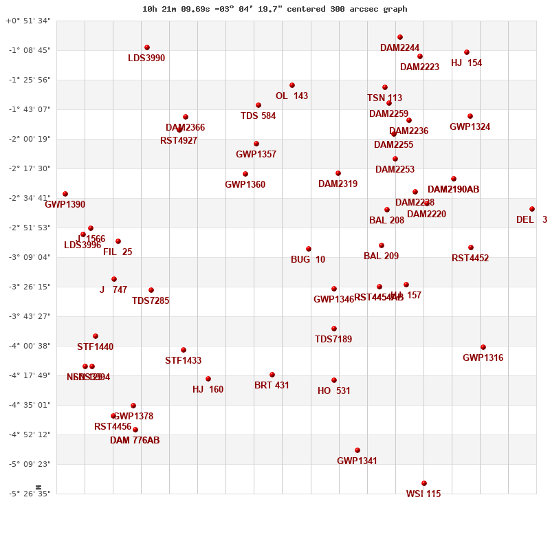
Click on the map to see the double of your interest.
Pass over with the mouse cursor to display the catalog designation.
|
| Show |
name |
coord_2000 |
discov# |
comp |
pa |
sep |
dist(') |
| Show |
|
10212-0304 |
BUG 10 |
|
164 |
0.2 |
1 |
| Show |
|
10201-0327 |
GWP1346 |
|
8 |
15.8 |
28 |
| Show |
|
10182-0303 |
BAL 209 |
|
220 |
17.4 |
45 |
| Show |
|
10200-0220 |
DAM2319 |
|
24 |
1.5 |
48 |
| Show |
|
10183-0326 |
RST4454 |
AB |
224 |
0.3 |
49 |
| Show |
|
10183-0326 |
BAL 210 |
AC |
25 |
20.1 |
49 |
| Show |
|
10201-0351 |
TDS7189 |
|
159 |
0.6 |
49 |
| Show |
|
10180-0242 |
BAL 208 |
|
1 |
6.5 |
53 |
| Show |
|
10237-0221 |
GWP1360 |
|
308 |
19.1 |
59 |
| Show |
|
10172-0325 |
HJ 157 |
|
132 |
20.2 |
63 |
| Show |
|
10233-0203 |
GWP1357 |
|
282 |
66.5 |
69 |
| Show |
|
10168-0231 |
DAM2228 |
|
73 |
4.3 |
73 |
| Show |
|
10176-0212 |
DAM2253 |
|
116 |
4.3 |
75 |
| Show |
|
10227-0417 |
BRT 431 |
|
159 |
5.2 |
77 |
| Show |
|
10164-0238 |
DAM2220 |
|
313 |
25.6 |
77 |
| Show |
|
10201-0421 |
HO 531 |
|
122 |
3.1 |
78 |
| Show |
|
10177-0158 |
DAM2255 |
|
300 |
6.2 |
85 |
| Show |
|
10232-0141 |
TDS 584 |
|
3 |
1.0 |
89 |
| Show |
|
10219-0129 |
OL 143 |
|
213 |
2.8 |
96 |
| Show |
|
10262-0403 |
STF1433 |
|
264 |
23.7 |
97 |
| Show |
|
10171-0149 |
DAM2236 |
|
221 |
5.3 |
97 |
| Show |
|
10253-0419 |
HJ 160 |
|
290 |
11.4 |
97 |
| Show |
|
10153-0223 |
DAM2190 |
AB |
27 |
3.6 |
98 |
| Show |
|
10153-0223 |
DAM2190 |
AC |
91 |
21.1 |
98 |
| Show |
|
10179-0140 |
DAM2259 |
|
21 |
4.5 |
98 |
| Show |
|
10275-0328 |
TDS7285 |
|
66 |
1.5 |
99 |
| Show |
|
10146-0303 |
RST4452 |
|
246 |
0.4 |
99 |
| Show |
|
10264-0155 |
RST4927 |
|
314 |
0.5 |
105 |
| Show |
|
10181-0130 |
TSN 113 |
|
218 |
999.9 |
106 |
| Show |
|
10262-0147 |
DAM2366 |
|
211 |
1.5 |
108 |
| Show |
|
10289-0300 |
FIL 25 |
|
55 |
5.6 |
116 |
| Show |
|
10291-0322 |
J 747 |
|
253 |
3.5 |
120 |
| Show |
|
10141-0401 |
GWP1316 |
|
56 |
117.0 |
121 |
| Show |
|
10192-0502 |
GWP1341 |
|
81 |
65.0 |
121 |
| Show |
|
10146-0147 |
GWP1324 |
|
145 |
27.8 |
125 |
| Show |
|
10166-0112 |
DAM2223 |
|
319 |
6.7 |
131 |
| Show |
|
10301-0252 |
J 1566 |
|
270 |
12.3 |
134 |
| Show |
|
10174-0101 |
DAM2244 |
|
270 |
6.5 |
136 |
| Show |
|
10304-0257 |
LDS3996 |
|
75 |
2.8 |
138 |
| Show |
|
10121-0241 |
DEL 3 |
|
270 |
0.1 |
139 |
| Show |
|
10298-0355 |
STF1440 |
|
345 |
14.8 |
140 |
| Show |
|
10283-0436 |
GWP1378 |
|
158 |
35.1 |
141 |
| Show |
|
10300-0413 |
LDS3994 |
|
140 |
36.1 |
149 |
| Show |
|
10282-0450 |
DAM 776 |
AB |
233 |
13.1 |
149 |
| Show |
|
10282-0450 |
DAM 776 |
AC |
62 |
34.2 |
149 |
| Show |
|
10147-0110 |
HJ 154 |
|
148 |
19.9 |
150 |
| Show |
|
10310-0232 |
GWP1390 |
|
337 |
23.6 |
152 |
| Show |
|
10302-0413 |
NSN 129 |
|
101 |
1.0 |
152 |
| Show |
|
10277-0108 |
LDS3990 |
|
81 |
5.2 |
153 |
| Show |
|
10291-0442 |
RST4456 |
|
347 |
1.1 |
154 |
| Show |
|
10165-0521 |
WSI 115 |
|
195 |
3.2 |
154 |
|
|
WDS 10212-0304 : COMPONENTS
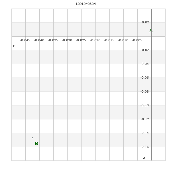
10212-0304 A
| Componente originario normalizzato |
AB |
|
Coord arcsec 2000 |
102109.69-030419.7 |
|
Mag |
17.81 |
|
Spectral class |
T1 (brown dwarf) |
|
10212-0304 B
| Componente originario normalizzato |
AB |
|
Coord arcsec 2000 |
102109.69-030419.8 |
|
Mag |
17.87 |
|
Spectral class |
T5 (brown dwarf) |
|
| Calc delta mag |
0.06 |
|
Calc coord |
yes |
|