00580+0917 WNC 1
00h 58m 00.81s +09° 16' 43.1" P.A. 132.00 sep 5.3 mag 10.13,10.45 Sp G5
| Coord 2000 |
00580+0917 |
|
Discov num |
WNC 1 |
|
Comp |
|
|
Coord arcsec 2000 |
00 58 00.81 +09 16 43.1 |
|
| Date first |
1863 |
|
Date last |
2019 |
|
Obs |
27 |
|
| Pa first |
130 |
|
Pa last |
131.5 |
|
P.A. Now (θ) |
131.5° |
|
| Sep first |
5.3 |
|
Sep last |
5.267 |
|
Sep. Now (ρ) |
5.267" |
|
| Mag pri |
10.13 |
|
Mag sec |
10.45 |
|
delta mag (ΔM) |
0.32 |
|
Spectral class |
G5 (yellow) |
|
| Pri motion ra |
-054 |
|
Sec motion ra |
-009 |
|
| Pri motion dec |
-022 |
|
Sec motion dec |
-055 |
|
| Notes |
|
|
rPM=0.957
This double is not physical.
OTHER CATALOGS AND DESIGNATIONS
| Constellation |
Pisces |
|
Tycho2 |
0605-00387-1 |
|
Gaia DR2 |
2581429521337662464 |
|
WDS 00580+0917 WNC 1 : NOTES
No records found.
REFERENCES
| refcode |
metd |
author |
reference |
| Wnc1855 |
orb - |
Winnecke, A. |
1855AN.....41..101W |
| Wnc1855 |
|
AN 41, 101, #967, 1855 |
|
| Wnc1856 |
orb - |
Winnecke, A. |
. |
| Wnc1856 |
|
Inaug. Diss. Berlin, 1856 |
|
| Wnc1869 |
Ma j |
Winnecke, A. |
1869AN.....73..145W |
| Wnc1869 |
+D |
AN 73, 145, 1869 |
|
| Wnc1893 |
Ma - |
Winnecke, A. (measure in Struve, O.) |
1893ObPul 10....1S |
| Wnc1893 |
|
Pulkova Obs. Observations 10, 1893 |
|
| Wnc1906A |
Ma - |
Winnecke, A. |
. |
| Wnc1906A |
|
cited by Burnham (via Skf2013) |
. |
| Wnc1909 |
Ma - |
Winnecke, A. |
. |
| Wnc1909 |
|
Ann. Uni.-Obs. Strassburg 3, 1909 |
|
| Wnc1906A |
Ma - |
Winnecke, A. |
1906MmRAS..56....1L |
| Wnc1906A |
|
cited by Lewis (MemRAS 56, 1, 1906) |
|
| Wnc1937A |
Ma - |
Winnecke, A. |
1937AnLei..18....1S |
| Wnc1937A |
|
cited by Strand (Ann. Sterrew. Leiden 18, 1937) |
|
WDS HISTORIC DATA
| coord_2000 |
discov_num |
comp |
epoch |
obs |
pa |
sep |
mag_pri |
mag_sec |
spectr |
notes |
coord_arcsec_2000 |
| 00580+0917 |
WNC 1 |
|
2000 |
18 |
131 |
5.3 |
10.13 |
10.45 |
G5 |
D |
005800.81+091643.1 |
| 00580+0917 |
WNC 1 |
|
2009 |
19 |
131 |
5.4 |
10.13 |
10.45 |
G5 |
D |
005800.81+091643.1 |
| 00580+0917 |
WNC 1 |
|
2016 |
22 |
132 |
5.3 |
10.13 |
10.45 |
G5 |
|
005800.81+091643.1 |
| 00580+0917 |
WNC 1 |
|
2019 |
26 |
132 |
5.3 |
10.13 |
10.45 |
G5 |
|
005800.81+091643.1 |
If you need more information about this double, apply for a
data request form to the WDS.
WDS 00580+0917 WNC 1 : VISUAL OBSERVATIONS REPORTS
No records found.
WDS 00580+0917 WNC 1 : MEASURES
No records found.
WDS 00580+0917 : VIRTUAL EYEPIECE
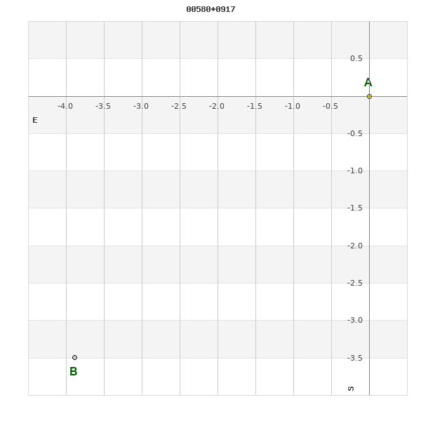
Click on the map to see the double of your interest.
Pass over with the mouse cursor to display the catalog designation.
|
|
WDS 00580+0917 : ALADIN DSS IMAGE @ 00h 58m 00.81s +09° 16' 43.1"
WDS 00580+0917 WNC 1 : NEIGHBORHOODS
|
|
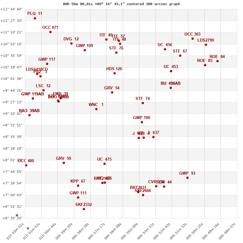
Click on the map to see the double of your interest.
Pass over with the mouse cursor to display the catalog designation.
|
| Show |
name |
coord_2000 |
discov# |
comp |
pa |
sep |
dist(') |
| Show |
|
00580+0917 |
WNC 1 |
|
132 |
5.3 |
1 |
| Show |
|
00568+0941 |
GRV 54 |
|
334 |
17.0 |
30 |
| Show |
|
01005+0933 |
FMR 39 |
|
251 |
19.4 |
41 |
| Show |
|
01007+0929 |
DOO 25 |
CD |
197 |
10.6 |
41 |
| Show |
|
01007+0929 |
STF 82 |
AB |
304 |
1.9 |
42 |
| Show |
|
01007+0929 |
DOO 25 |
AC |
214 |
74.5 |
42 |
| Show |
|
00548+0926 |
STF 74 |
|
298 |
3.1 |
50 |
| Show |
|
00548+0857 |
GWP 100 |
|
12 |
43.3 |
52 |
| Show |
|
00567+1010 |
HDS 126 |
|
65 |
0.8 |
57 |
| Show |
|
01017+0945 |
LSC 12 |
|
228 |
1.1 |
62 |
| Show |
|
00550+0834 |
J 638 |
|
206 |
3.3 |
62 |
| Show |
|
00547+0834 |
WZ 2 |
|
269 |
8.6 |
66 |
| Show |
|
01025+0933 |
GWP 119 |
AB |
107 |
29.4 |
68 |
| Show |
|
01025+0933 |
GWP 119 |
AC |
247 |
1.4 |
68 |
| Show |
|
01027+0908 |
RAO 39 |
AB |
37 |
2.8 |
71 |
| Show |
|
01027+0908 |
RAO 39 |
AC |
146 |
31.7 |
71 |
| Show |
|
00540+0836 |
J 637 |
|
173 |
3.0 |
73 |
| Show |
|
01019+1005 |
PRZ 3 |
|
68 |
2.3 |
76 |
| Show |
|
01076+2257 |
LDS6410 |
CD |
222 |
8.9 |
81 |
| Show |
|
01022+1009 |
NSN 776 |
|
284 |
3.4 |
81 |
| Show |
|
00574+0756 |
UC 475 |
|
68 |
7.6 |
82 |
| Show |
|
00528+0948 |
BU 498 |
AB |
151 |
4.1 |
84 |
| Show |
|
00528+0948 |
FOX 114 |
AC |
224 |
48.4 |
84 |
| Show |
|
01015+1024 |
GWP 117 |
|
201 |
21.9 |
85 |
| Show |
|
00566+1040 |
STF 76 |
|
199 |
3.0 |
87 |
| Show |
|
01003+0757 |
GRV 59 |
|
115 |
50.5 |
87 |
| Show |
|
00588+1044 |
GWP 109 |
|
212 |
14.5 |
89 |
| Show |
|
00528+1013 |
UC 453 |
|
315 |
24.6 |
96 |
| Show |
|
00563+1053 |
ITF 48 |
|
126 |
2.1 |
100 |
| Show |
|
00598+1054 |
DVG 12 |
|
56 |
54.6 |
101 |
| Show |
|
00573+1100 |
ITF 49 |
|
291 |
11.3 |
104 |
| Show |
|
00564+1058 |
ITF 57 |
|
302 |
9.7 |
104 |
| Show |
|
00576+0727 |
BRT2106 |
|
29 |
4.7 |
110 |
| Show |
|
00574+0728 |
UC 476 |
|
61 |
11.7 |
110 |
| Show |
|
01029+0753 |
OCC 480 |
|
-1 |
0.3 |
111 |
| Show |
|
00532+1045 |
UC 456 |
|
297 |
52.5 |
114 |
| Show |
|
00593+0723 |
KPP 67 |
|
330 |
3.8 |
115 |
| Show |
|
00521+1036 |
STF 67 |
|
349 |
2.3 |
118 |
| Show |
|
01012+1111 |
OCC 871 |
|
-1 |
0.1 |
124 |
| Show |
|
00538+0723 |
CVR 351 |
|
319 |
12.9 |
130 |
| Show |
|
00551+0714 |
BRT2831 |
|
112 |
13.2 |
131 |
| Show |
|
00512+1020 |
ROE 85 |
|
139 |
3.7 |
131 |
| Show |
|
00593+0706 |
GWP 111 |
|
214 |
11.4 |
133 |
| Show |
|
00533+0722 |
SLW 44 |
|
235 |
29.2 |
135 |
| Show |
|
00547+0709 |
SKF2666 |
|
217 |
1.0 |
137 |
| Show |
|
00516+0735 |
GWP 93 |
|
276 |
14.8 |
139 |
| Show |
|
00513+1101 |
OCC 303 |
|
-1 |
0.1 |
145 |
| Show |
|
00492+1028 |
ROE 84 |
|
126 |
7.9 |
145 |
| Show |
|
00589+0649 |
SKF2332 |
|
82 |
2.2 |
149 |
| Show |
|
00503+1052 |
LDS2799 |
|
71 |
41.7 |
149 |
| Show |
|
01023+1131 |
PLQ 11 |
|
3 |
9.9 |
149 |
|
|
WDS 00580+0917 : COMPONENTS
00580+0917 A
| Componente originario normalizzato |
AB |
|
Coord arcsec 2000 |
005800.81+091643.1 |
|
Mag |
10.13 |
|
Spectral class |
G5 (yellow) |
|
| PmRA |
-54.00 |
|
PmDE |
-22.0 |
|
Tycho2 |
0605-00387-1 |
|
| Tycho2 |
0605-00387-1 |
|
Pflag |
|
|
RAmdeg |
14.50335476 |
|
DEmdeg |
9.27864385 |
|
| PmRA |
-55.1 |
|
PmDE |
-22.6 |
|
E RAmdeg |
31 |
|
E DEmdeg |
41 |
|
| E pmRA |
2.2 |
|
E pmDE |
2.1 |
|
EpRAm |
1988.51 |
|
EpDEm |
1985.42 |
|
| Num |
5 |
|
Q RAmdeg |
0.8 |
|
Q DEmdeg |
0.4 |
|
Q pmRA |
0.8 |
|
| Q pmDE |
0.4 |
|
BTmag |
11.157 |
|
E BTmag |
0.077 |
|
VTmag |
10.125 |
|
| E VTmag |
0.048 |
|
Prox |
54 |
|
TYC |
T |
|
HIP |
|
|
| CCDM |
|
|
RAdeg |
14.50348194 |
|
DEdeg |
9.27869556 |
|
EpRA 1990 |
1.74 |
|
| EpDE 1990 |
1.73 |
|
E RAdeg |
31.5 |
|
E DEdeg |
42.6 |
|
Posflg |
|
|
| Corr |
0.1 |
|
| Ccdm |
00580+0917 |
|
RComp |
|
|
Comp |
A |
|
Note1 |
|
|
| Note2 |
|
|
Discov num |
|
|
DRAs |
0.77 |
|
DDEs |
-16.8 |
|
| R dRAs |
10 |
|
Year |
|
|
Theta |
|
|
Rho |
|
|
| Obs |
2 |
|
Vmag |
10.3 |
|
Sp |
G5 |
|
PmNote |
* |
|
| PmRA |
-56 |
|
PmDE |
-23 |
|
Dm number |
+08 137 |
|
Cat1 |
BD |
|
| Name2 |
+09 79 |
|
Cat2 |
AGK2/3 |
|
HD |
|
|
M HD |
|
|
| ADS BDS |
A 802 |
|
M ADS BDS |
|
|
N IDS |
|
|
IDS |
00528N0844A |
|
| HIC |
|
|
00580+0917 B
| Componente originario normalizzato |
AB |
|
Coord arcsec 2000 |
005801.07+091639.6 |
|
Mag |
10.45 |
|
PmRA |
-9.00 |
|
| PmDE |
-55.0 |
|
Tycho2 |
0605-00387-2 |
|
Calc delta mag |
0.32 |
|
Calc coord |
yes |
|
| Tycho2 |
0605-00387-2 |
|
Pflag |
|
|
RAmdeg |
14.50450675 |
|
DEmdeg |
9.27767448 |
|
| PmRA |
-55.1 |
|
PmDE |
-23.4 |
|
E RAmdeg |
39 |
|
E DEmdeg |
53 |
|
| E pmRA |
3.0 |
|
E pmDE |
2.9 |
|
EpRAm |
1990.03 |
|
EpDEm |
1987.95 |
|
| Num |
2 |
|
Q RAmdeg |
|
|
Q DEmdeg |
|
|
Q pmRA |
|
|
| Q pmDE |
|
|
BTmag |
11.344 |
|
E BTmag |
0.087 |
|
VTmag |
10.453 |
|
| E VTmag |
0.061 |
|
Prox |
54 |
|
TYC |
T |
|
HIP |
|
|
| CCDM |
|
|
RAdeg |
14.50463472 |
|
DEdeg |
9.27772833 |
|
EpRA 1990 |
1.76 |
|
| EpDE 1990 |
1.69 |
|
E RAdeg |
39.0 |
|
E DEdeg |
53.5 |
|
Posflg |
|
|
| Corr |
0.1 |
|
| Ccdm |
00580+0917 |
|
RComp |
|
|
Comp |
B |
|
Note1 |
|
|
| Note2 |
|
|
Discov num |
WNC 1 |
|
DRAs |
|
|
DDEs |
|
|
| R dRAs |
|
|
Year |
1863 |
|
Theta |
128 |
|
Rho |
5.3 |
|
| Obs |
16 |
|
Vmag |
10.5 |
|
Sp |
|
|
PmNote |
|
|
| PmRA |
|
|
PmDE |
|
|
Dm number |
|
|
Cat1 |
|
|
| Name2 |
|
|
Cat2 |
|
|
HD |
|
|
M HD |
|
|
| ADS BDS |
A 802 |
|
M ADS BDS |
|
|
N IDS |
|
|
IDS |
00528N0844B |
|
| HIC |
|
|