00576+5424 HLD 4 (HD 5502)
00h 57m 35.79s +54° 23' 44.8" P.A. 50.00 sep 0.4 mag 9.00,9.50 Sp G0
| Coord 2000 |
00576+5424 |
|
Discov num |
HLD 4 |
|
Comp |
|
|
Coord arcsec 2000 |
00 57 35.79 +54 23 44.8 |
|
| Date first |
1881 |
|
Date last |
2016 |
|
Obs |
37 |
|
| Pa first |
125 |
|
Pa last |
50 |
|
P.A. Now (θ) |
50° |
|
| Sep first |
1.0 |
|
Sep last |
0.406 |
|
Sep. Now (ρ) |
0.406" |
|
| Mag pri |
9.00 |
|
Mag sec |
9.50 |
|
delta mag (ΔM) |
0.5 |
|
Spectral class |
G0 (yellow) |
|
| Pri motion ra |
+054 |
|
Sec motion ra |
|
|
| Pri motion dec |
-014 |
|
Sec motion dec |
|
|
| Notes |
O
(Orbital solution) |
|
This double is physical.
OTHER CATALOGS AND DESIGNATIONS
| Name |
HD 5502 |
|
Constellation |
Cassiopeia |
|
SAO |
21874 |
|
Tycho2 |
3672-00063-1 |
|
| Gaia DR2 |
417343518342363136 |
|
HD |
5502 |
|
ADS |
795 |
|
ORBITAL ELEMENTS
| Period (P) | 788.16y | |
Periastron (T) | 1990.92y | |
Semi-major axis (a) | 0.948a | |
| Eccentricity (e) | 0.892 | |
Inclination (i) | 13.3° | |
Longitude of periastron (ω) | 191.7° | |
| Node (Ω) | 90.1° | |
Notes | | |
Reference | Mnt2001c | |
| Equinox | | |
Last observation | 1996 | |
Grade | 4 | (1=Definitive, 9=Indet.) |
| label |
theta |
rho |
| 2000 |
16.0 |
0.201 |
| 2001 |
20.2 |
0.216 |
| 2002 |
23.8 |
0.230 |
| 2003 |
27.0 |
0.245 |
| 2004 |
29.9 |
0.259 |
| 2005 |
32.5 |
0.273 |
| 2006 |
34.8 |
0.287 |
| 2007 |
36.8 |
0.301 |
| 2008 |
38.8 |
0.314 |
| 2009 |
40.5 |
0.328 |
| 2010 |
42.1 |
0.341 |
| 2011 |
43.6 |
0.354 |
| 2012 |
45.0 |
0.366 |
| 2013 |
46.3 |
0.379 |
| 2014 |
47.5 |
0.391 |
| 2015 |
48.7 |
0.404 |
| 2016 |
49.8 |
0.416 |
| 2017 |
50.8 |
0.427 |
| 2018 |
51.7 |
0.439 |
| 2019 |
52.7 |
0.451 |
| 2020 |
53.5 |
0.462 |
| 2021 |
54.3 |
0.473 |
| 2022 |
55.1 |
0.484 |
| 2023 |
55.9 |
0.495 |
| 2024 |
56.6 |
0.506 |
| 2025 |
57.3 |
0.517 |
| 2026 |
58.0 |
0.528 |
| 2027 |
58.6 |
0.538 |
| 2028 |
59.2 |
0.548 |
| 2029 |
59.8 |
0.559 |
| 2030 |
60.4 |
0.569 |
|
|
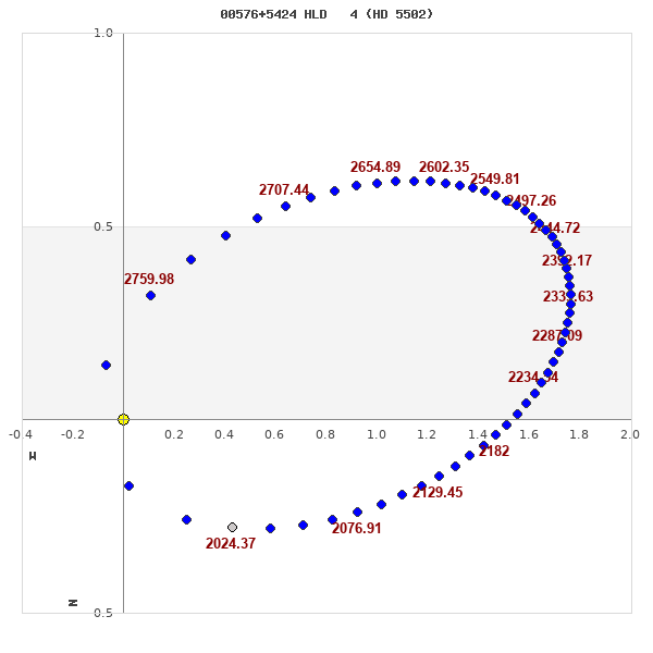
Note: Theta is PA, Rho is Sep. For yearly orbits, data refer to Jan 1st.
|
|
|
|
|
|
|
|
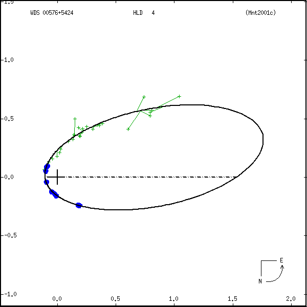
Measures: green=micrometric, blue=interferometric, purple=photographic |
|
WDS 00576+5424 HLD 4 (HD 5502) : NOTES
No records found.
REFERENCES
| refcode |
metd |
author |
reference |
| Mnt2001c |
orb - |
Mante, R. |
2001IAUDS.145....1M |
| Mnt2001c |
|
Inf. Circ. 145, 1, 2001 |
|
DISCOVERER
| idgroup |
discov |
author |
| 1 |
HLD |
Holden, E.S. |
WDS HISTORIC DATA
| coord_2000 |
discov_num |
comp |
epoch |
obs |
pa |
sep |
mag_pri |
mag_sec |
spectr |
notes |
coord_arcsec_2000 |
| 00576+5424 |
HLD 4 |
|
1996 |
33 |
357 |
0.2 |
9.00 |
9.50 |
G0 |
O |
005735.79+542344.8 |
| 00576+5424 |
HLD 4 |
|
2007 |
34 |
38 |
0.3 |
9.00 |
9.50 |
G0 |
O |
005735.79+542344.8 |
| 00576+5424 |
HLD 4 |
|
2009 |
36 |
41 |
0.3 |
9.00 |
9.50 |
G0 |
O |
005735.79+542344.8 |
| 00576+5424 |
HLD 4 |
|
2016 |
37 |
50 |
0.4 |
9.00 |
9.50 |
G0 |
O |
005735.79+542344.8 |
If you need more information about this double, apply for a
data request form to the WDS.
WDS 00576+5424 HLD 4 (HD 5502) : VISUAL OBSERVATIONS REPORTS
No records found.
WDS 00576+5424 HLD 4 (HD 5502) : MEASURES
No records found.
WDS 00576+5424 (HD 5502) : VIRTUAL EYEPIECE
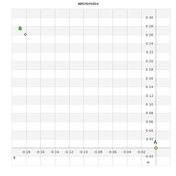
Click on the map to see the double of your interest.
Pass over with the mouse cursor to display the catalog designation.
|
|
WDS 00576+5424 (HD 5502) : ALADIN DSS IMAGE @ 00h 57m 35.79s +54° 23' 44.8"
WDS 00576+5424 HLD 4 (HD 5502) : NEIGHBORHOODS
|
|

Click on the map to see the double of your interest.
Pass over with the mouse cursor to display the catalog designation.
|
| Show |
name |
coord_2000 |
discov# |
comp |
pa |
sep |
dist(') |
| Show |
|
00576+5424 |
HLD 4 |
|
50 |
0.4 |
1 |
| Show |
|
00584+5426 |
HJ 2003 |
|
332 |
16.8 |
7 |
| Show |
|
00561+5406 |
A 1259 |
|
105 |
0.1 |
22 |
| Show |
|
00562+5403 |
ES 754 |
|
198 |
5.9 |
25 |
| Show |
|
00544+5432 |
A 1258 |
|
200 |
0.6 |
30 |
| Show |
|
00590+5354 |
ES 615 |
|
269 |
3.3 |
32 |
| Show |
|
01013+5434 |
TDS1719 |
Aa,Ab |
11 |
1.7 |
34 |
| Show |
|
00538+5434 |
ES 938 |
|
215 |
4.2 |
35 |
| Show |
|
00547+5448 |
TDS1663 |
|
333 |
0.7 |
36 |
| Show |
|
00527+5434 |
STI1456 |
|
339 |
8.6 |
44 |
| Show |
|
00546+5501 |
TDS1662 |
|
351 |
0.5 |
46 |
| Show |
|
01015+5458 |
TDS1723 |
|
196 |
0.7 |
49 |
| Show |
|
01013+5341 |
ES 941 |
|
61 |
3.7 |
53 |
| Show |
|
00517+5412 |
KPP3136 |
|
173 |
50.1 |
54 |
| Show |
|
00578+5519 |
TDS1683 |
|
52 |
1.7 |
56 |
| Show |
|
01018+5343 |
TDS1729 |
|
298 |
0.5 |
56 |
| Show |
|
01016+5339 |
HJ 2008 |
|
69 |
7.2 |
57 |
| Show |
|
00511+5437 |
BKO 161 |
|
117 |
27.7 |
59 |
| Show |
|
00524+5344 |
ES 614 |
|
87 |
1.8 |
62 |
| Show |
|
01030+5506 |
TDS1744 |
|
117 |
0.7 |
63 |
| Show |
|
01003+5522 |
STI1508 |
|
351 |
12.4 |
64 |
| Show |
|
00508+5437 |
STI1445 |
|
315 |
10.8 |
64 |
| Show |
|
01017+5330 |
UC 8 |
|
350 |
19.1 |
66 |
| Show |
|
01036+5345 |
TDS1747 |
|
318 |
0.8 |
66 |
| Show |
|
00501+5434 |
ES 937 |
|
190 |
5.9 |
67 |
| Show |
|
00595+5530 |
STI1504 |
|
14 |
12.2 |
69 |
| Show |
|
00550+5530 |
ES 939 |
|
343 |
6.4 |
70 |
| Show |
|
00529+5520 |
STI1460 |
|
92 |
9.6 |
70 |
| Show |
|
00545+5528 |
STI1466 |
|
326 |
10.7 |
70 |
| Show |
|
01057+5432 |
STI1530 |
|
178 |
15.0 |
71 |
| Show |
|
00494+5431 |
STI1435 |
|
28 |
14.6 |
72 |
| Show |
|
00495+5440 |
STI1436 |
|
195 |
8.7 |
73 |
| Show |
|
00494+5432 |
HSW 2 |
|
87 |
12.2 |
73 |
| Show |
|
00497+5451 |
STI1438 |
|
278 |
17.9 |
74 |
| Show |
|
00491+5427 |
MRI 45 |
|
269 |
44.8 |
75 |
| Show |
|
00555+5539 |
STI1477 |
|
188 |
10.0 |
78 |
| Show |
|
01065+5325 |
ES 616 |
|
282 |
3.4 |
78 |
| Show |
|
00530+5532 |
STI1462 |
|
313 |
5.2 |
79 |
| Show |
|
00528+5533 |
TDS1654 |
|
28 |
0.5 |
81 |
| Show |
|
00592+5303 |
KPP3138 |
|
35 |
2.8 |
82 |
| Show |
|
00482+5405 |
ES 753 |
|
117 |
8.0 |
85 |
| Show |
|
00514+5529 |
STI1447 |
|
94 |
4.1 |
85 |
| Show |
|
00581+5549 |
STI1491 |
|
301 |
11.9 |
86 |
| Show |
|
01074+5426 |
TDS1779 |
|
208 |
1.3 |
86 |
| Show |
|
00562+5549 |
STI1482 |
|
267 |
12.0 |
86 |
| Show |
|
00587+5550 |
STI1496 |
|
142 |
13.3 |
87 |
| Show |
|
00484+5500 |
TDS1619 |
|
193 |
0.9 |
88 |
| Show |
|
00521+5539 |
TDS1643 |
|
175 |
0.5 |
89 |
| Show |
|
00537+5546 |
STI1465 |
|
151 |
12.2 |
89 |
| Show |
|
00510+5532 |
MRI 46 |
|
122 |
514.7 |
89 |
| Show |
|
01047+5529 |
DAM1277 |
|
345 |
3.7 |
90 |
|
|
WDS 00576+5424 : COMPONENTS
00576+5424 A
| Componente originario normalizzato |
AB |
|
Name |
HD 5502 |
|
Coord arcsec 2000 |
005735.79+542344.8 |
|
Mag |
9 |
|
| Spectral class |
G0 (yellow) |
|
PmRA |
54.00 |
|
PmDE |
-14.0 |
|
SAO |
21874 |
|
| Tycho2 |
3672-00063-1 |
|
HD |
5502 |
|
DM |
BD+53 184 |
|
| Tycho2 |
3672-00063-1 |
|
Pflag |
|
|
RAmdeg |
14.39914608 |
|
DEmdeg |
54.39578560 |
|
| PmRA |
51.4 |
|
PmDE |
-30.0 |
|
E RAmdeg |
6 |
|
E DEmdeg |
6 |
|
| E pmRA |
1.3 |
|
E pmDE |
1.4 |
|
EpRAm |
1991.35 |
|
EpDEm |
1991.51 |
|
| Num |
7 |
|
Q RAmdeg |
0.7 |
|
Q DEmdeg |
0.8 |
|
Q pmRA |
0.6 |
|
| Q pmDE |
0.9 |
|
BTmag |
8.920 |
|
E BTmag |
0.016 |
|
VTmag |
8.403 |
|
| E VTmag |
0.012 |
|
Prox |
999 |
|
TYC |
T |
|
HIP |
|
|
| CCDM |
|
|
RAdeg |
14.39894472 |
|
DEdeg |
54.39585333 |
|
EpRA 1990 |
1.77 |
|
| EpDE 1990 |
1.85 |
|
E RAdeg |
5.5 |
|
E DEdeg |
5.8 |
|
Posflg |
|
|
| Corr |
0.1 |
|
| SAO |
21874 |
|
DelFlag |
|
|
RA1950 |
|
|
PmRA1950 |
0.0058 |
|
| DE1950 |
|
|
PmDE1950 |
-0.012 |
|
Vmag |
8 |
|
SpType |
G0 |
|
| Double code |
|
|
Source |
37 |
|
CatNum |
427 |
|
DM |
BD+53 184 |
|
| DMcomp |
|
|
BDsup |
|
|
HD |
5502 |
|
M HD |
0 |
|
| GC |
|
|
RA1950rad |
0.23847243 |
|
DE1950rad |
0.94468051 |
|
PmRA2000 |
0.0059 |
|
| PmDE2000 |
-0.017 |
|
| Ccdm |
00576+5424 |
|
RComp |
|
|
Comp |
A |
|
Note1 |
|
|
| Note2 |
|
|
Discov num |
|
|
DRAs |
-0.20 |
|
DDEs |
-13.7 |
|
| R dRAs |
10 |
|
Year |
|
|
Theta |
|
|
Rho |
|
|
| Obs |
2 |
|
Vmag |
9.0 |
|
Sp |
G0 |
|
PmNote |
* |
|
| PmRA |
55 |
|
PmDE |
-8 |
|
Dm number |
+53 184 |
|
Cat1 |
BD |
|
| Name2 |
+54 89 |
|
Cat2 |
AGK2/3 |
|
HD |
5502 |
|
M HD |
|
|
| ADS BDS |
A 795 |
|
M ADS BDS |
|
|
N IDS |
|
|
IDS |
00517N5351A |
|
| HIC |
|
|
00576+5424 B
| Componente originario normalizzato |
AB |
|
Coord arcsec 2000 |
005735.81+542345.1 |
|
Mag |
9.5 |
|
Calc delta mag |
0.5 |
|
| Calc coord |
yes |
|
| Ccdm |
00576+5424 |
|
RComp |
|
|
Comp |
B |
|
Note1 |
|
|
| Note2 |
|
|
Discov num |
HLD 4 |
|
DRAs |
|
|
DDEs |
|
|
| R dRAs |
|
|
Year |
1960 |
|
Theta |
150 |
|
Rho |
0.5 |
|
| Obs |
9 |
|
Vmag |
9.5 |
|
Sp |
|
|
PmNote |
|
|
| PmRA |
|
|
PmDE |
|
|
Dm number |
|
|
Cat1 |
|
|
| Name2 |
|
|
Cat2 |
|
|
HD |
|
|
M HD |
|
|
| ADS BDS |
A 795 |
|
M ADS BDS |
|
|
N IDS |
|
|
IDS |
00517N5351B |
|
| HIC |
|
|