00571+1239 HEI 304
00h 57m 08.62s +12° 38' 17.7" P.A. 87.00 sep 0.8 mag 11.80,11.80
| Coord 2000 |
00571+1239 |
|
Discov num |
HEI 304 |
|
Comp |
|
|
Coord arcsec 2000 |
00 57 08.62 +12 38 17.7 |
|
| Date first |
1986 |
|
Date last |
2016 |
|
Obs |
5 |
|
| Pa first |
90 |
|
Pa last |
86.5 |
|
P.A. Now (θ) |
86.5° |
|
| Sep first |
0.7 |
|
Sep last |
0.79 |
|
Sep. Now (ρ) |
0.79" |
|
| Mag pri |
11.80 |
|
Mag sec |
11.80 |
|
delta mag (ΔM) |
0 |
|
Spectral class |
|
|
| Pri motion ra |
+026 |
|
Sec motion ra |
|
|
| Pri motion dec |
+006 |
|
Sec motion dec |
|
|
| Notes |
|
|
Nature of this double is uncertain.
OTHER CATALOGS AND DESIGNATIONS
| Constellation |
Pisces |
|
Tycho2 |
0611-00686-1 |
|
Gaia DR2 |
2776525455821040256 |
|
WDS 00571+1239 HEI 304 : NOTES
No records found.
REFERENCES
| refcode |
metd |
author |
reference |
| Hei1954 |
orb - |
Heintz, W.D. |
1954MNRAS.114..600H |
| Hei1954 |
|
MNRAS 114, 600-605, 1954 |
|
| Hei1956a |
M+ - |
Heintz, W.D. |
1956MNRAS.116..248H |
| Hei1956a |
+orb |
MNRAS 116, 248, 1956 |
|
| Hei1956b |
orb - |
Heintz, W.D. |
1956AN....283..145H |
| Hei1956b |
|
AN 283, 145, 1956 |
|
| Hei1958 |
orb - |
Heintz, W.D. |
1958Obs....78...32H |
| Hei1958 |
|
Observatory 78, 32, 1958 |
|
| Hei1960a |
orb - |
Heintz, W.D. |
1960VeMun...5...87H |
| Hei1960a |
|
Veroff. Sternw. Munchen 5, 87-114, 1960 |
|
| Hei1960b |
Ma - |
Heintz, W.D. |
1960AN....285..249H |
| Hei1960b |
+orb |
AN 285, 249, 1960 |
|
| Hei1960c |
orb - |
Heintz, W.D. |
1960AN....285..255H |
| Hei1960c |
|
AN 285, 255, 1960 |
|
| Hei1961 |
Ma - |
Heintz, W.D. |
1961JO.....44..158H |
| Hei1961 |
|
J. Obs. 44, 158, 1961 |
|
| Hei1962 |
orb - |
Heintz, W.D. |
1962VeMun...5..135H |
| Hei1962 |
|
Veroff. Sternw. Munchen 5, 135-160, 1962 |
|
| Hei1963a |
orb - |
Heintz, W.D. |
1963VeMun...5..247H |
| Hei1963a |
|
Veroff. Sternw. Munchen 5, 247-268, 1963 |
|
| Hei1963b |
Ma - |
Heintz, W.D. |
1963JO.....46....1H |
| Hei1963b |
|
J. Obs. 46, 1, 1963 |
|
| Hei1963c |
orb - |
Heintz, W.D. |
1963ZA.....57..159H |
| Hei1963c |
|
ZfAp 57, 159, 1963 |
|
| Hei1965a |
Ma - |
Heintz, W.D. |
1965JO.....48....5H |
| Hei1965a |
|
J. Obs. 48, 5-10, 1965 |
|
| Hei1965b |
Po j |
Heintz, W.D. |
1965AN....289..101H |
| Hei1965b |
|
AN 289, 101, 1965 |
|
| Hei1965c |
orb - |
Heintz, W.D. |
1965VeMun...7....7H |
| Hei1965c |
|
Veroff. Sternw. Munchen 7, 7-14, 1965 |
|
| Hei1966 |
orb - |
Heintz, W.D. |
1966VeMun...7...19H |
| Hei1966 |
|
Veroff. Sternw. Munchen 7, 19-28, 1966 |
|
| Hei1967a |
orb - |
Heintz, W.D. |
1967VeMun...7...29H |
| Hei1967a |
|
Veroff. Sternw. Munchen 7, 29-34, 1967 |
|
| Hei1967b |
Ma - |
Heintz, W.D. |
1967JO.....50..343H |
| Hei1967b |
+orb |
J. Obs. 50, 343, 1967 |
|
| Hei1967c |
orb - |
Heintz, W.D. |
1967AN....289..269H |
| Hei1967c |
|
AN 289, 269, 1967 |
|
| Hei1967d |
orb - |
Heintz, W.D. |
1967JO.....50..357H |
| Hei1967d |
|
J. Obs. 50, 357, 1967 |
|
| Hei1968a |
orb - |
Heintz, W.D. |
1968AJ.....73..512H |
| Hei1968a |
|
AJ 73, 512, 1968 |
|
| Hei1968b |
orb - |
Heintz, W.D. |
1968IAUDS..44....1H |
| Hei1968b |
|
Inf. Circ. 44, 1, 1968 |
|
| Hei1969a |
orb - |
Heintz, W.D. |
1969A&A.....1..249H |
| Hei1969a |
|
A&A 1, 249, 1969 |
|
| Hei1969b |
orb - |
Heintz, W.D. |
1969A&A.....2..169H |
| Hei1969b |
|
A&A 2, 169, 1969 |
|
| Hei1969c |
orb - |
Heintz, W.D. |
1969AJ.....74..768H |
| Hei1969c |
|
AJ 74, 768, 1969 |
|
| Hei1969d |
orb - |
Heintz, W.D. |
1969IAUDS..47....1H |
| Hei1969d |
|
Inf. Circ. 47, 1, 1969 |
|
| Hei1970a |
Po j |
Heintz, W.D. |
1970AJ.....75..848H |
| Hei1970a |
+orb |
AJ 75, 848, 1970 |
|
| Hei1970b |
Ma - |
Heintz, W.D. |
1970A&AS....1..393H |
| Hei1970b |
|
A&AS 1, 393, 1970 |
|
| Hei1971 |
orb - |
Heintz, W.D. |
1971AJ.....76..277H |
| Hei1971 |
|
AJ 76, 277, 1971 |
|
| Hei1972 |
Po - |
Heintz, W.D. |
1972AJ.....77..160H |
| Hei1972 |
+orb |
AJ 77, 160, 1972 |
|
| Hei1973a |
orb - |
Heintz, W.D. |
1973PASP...85..408H |
| Hei1973a |
|
PASP 85, 408, 1973 |
|
| Hei1973b |
orb - |
Heintz, W.D. |
1973AJ.....78..208H |
| Hei1973b |
|
AJ 78, 208, 1973 |
|
| Hei1973c |
orb - |
Heintz, W.D. |
1973AJ.....78..307H |
| Hei1973c |
|
AJ 78, 307, 1973 |
|
| Hei1973d |
orb - |
Heintz, W.D. |
1973IAUDS..60....1H |
| Hei1973d |
|
Inf. Circ. 60, 1, 1973 |
|
| Hei1974a |
orb - |
Heintz, W.D. |
1974ApJ...195..411H |
| Hei1974a |
|
ApJ 195, 411, 1974 |
|
| Hei1974b |
orb - |
Heintz, W.D. |
1974AJ.....79..397H |
| Hei1974b |
|
AJ 79, 397, 1974 |
|
| Hei1974c |
Po j |
Heintz, W.D. |
1974AJ.....79..819H |
| Hei1974c |
+orb |
AJ 79, 819, 1974 |
|
| Hei1975a |
Ma - |
Heintz, W.D. |
1975ApJS...29..315H |
| Hei1975a |
+Po |
ApJS 29, 315, 1975 |
|
| Hei1975b |
orb - |
Heintz, W.D. |
1975ApJS...29..331H |
| Hei1975b |
|
ApJS 29, 331, 1975 |
|
| Hei1976 |
orb - |
Heintz, W.D. |
1976ApJ...208..474H |
| Hei1976 |
|
ApJ 208, 474, 1976 |
|
| Hei1978a |
orb - |
Heintz, W.D. |
1978ApJS...37...71H |
| Hei1978a |
|
ApJS 37, 71, 1978 |
|
| Hei1978b |
M+ - |
Heintz, W.D. |
1978ApJS...37..343H |
| Hei1978b |
+Po |
ApJS 37, 343, 1978 |
|
| Hei1978c |
orb - |
Heintz, W.D. |
1978ApJS...37..515H |
| Hei1978c |
|
ApJS 37, 515, 1978 |
|
| Hei1978d |
- |
Heintz, W.D. |
1978ApJ...220..931H |
| Hei1978d |
|
ApJ 220, 931, 1978 |
|
| Hei1979a |
orb - |
Heintz, W.D. |
1979PASP...91..356H |
| Hei1979a |
|
PASP 91, 356, 1979 |
|
| Hei1979b |
orb - |
Heintz, W.D. |
1979ApJS...41..549H |
| Hei1979b |
|
ApJS 41, 549, 1979 |
|
| Hei1979c |
orb - |
Heintz, W.D. |
1979AJ.....84.1223H |
| Hei1979c |
|
AJ 84, 1223, 1979 |
|
| Hei1979d |
orb - |
Heintz, W.D. |
1979PASP...91..490H |
| Hei1979d |
|
PASP 91, 490, 1979 |
|
| Hei1980a |
Ma j |
Heintz, W.D. |
1980ApJS...44..111H |
| Hei1980a |
+Mb |
ApJS 44, 111, 1980 |
|
| Hei1980b |
orb - |
Heintz, W.D. |
1980IAUDS..82....1H |
| Hei1980b |
|
Inf. Circ. 82, 1, 1980 |
|
| Hei1981a |
orb - |
Heintz, W.D. |
1981ApJS...45..559H |
| Hei1981a |
|
ApJS 45, 559, 1981 |
|
| Hei1981b |
orb - |
Heintz, W.D. |
1981PASP...93...90H |
| Hei1981b |
|
PASP 93, 90, 1981 |
|
| Hei1981c |
orb - |
Heintz, W.D. |
1981PASP...93..328H |
| Hei1981c |
|
PASP 93, 328, 1981 |
|
| Hei1981d |
orb - |
Heintz, W.D. |
1981IAUDS..83....1H |
| Hei1981d |
|
Inf. Circ. 83, 1, 1981 |
|
| Hei1981e |
- |
Heintz, W.D. |
1981ApJS...46..247H |
| Hei1981e |
|
ApJS 46, 247, 1981 |
|
| Hei1981f |
orb - |
Heintz, W.D. |
1981IAUDS..84....1H |
| Hei1981f |
|
Inf. Circ. 84, 1, 1981 |
|
| Hei1981g |
orb - |
Heintz, W.D. |
1981IAUDS..85....1H |
| Hei1981g |
|
Inf. Circ. 85, 1, 1981 |
|
| Hei1982a |
orb - |
Heintz, W.D. |
1982Obs...102...42H |
| Hei1982a |
|
Observatory 102, 42, 1982 |
|
| Hei1982b |
orb - |
Heintz, W.D. |
1982IAUDS..86....1H |
| Hei1982b |
|
Inf. Circ. 86, 1, 1982 |
|
| Hei1982c |
orb - |
Heintz, W.D. |
1982A&AS...47..569H |
| Hei1982c |
|
A&AS 47, 569, 1982 |
|
| Hei1982d |
orb - |
Heintz, W.D. |
1982IAUDS..88....1H |
| Hei1982d |
|
Inf. Circ. 88, 1, 1982 |
|
| Hei1982e |
orb - |
Heintz, W.D. |
1982PASP...94..705H |
| Hei1982e |
|
PASP 94, 705, 1982 |
|
| Hei1983a |
M+ j |
Heintz, W.D. |
1983ApJS...51..249H |
| Hei1983a |
+Po |
ApJS 51, 249, 1983 |
|
| Hei1983b |
orb - |
Heintz, W.D. |
1983IAUDS..89....1H |
| Hei1983b |
|
Inf. Circ. 89, 1, 1983 |
|
| Hei1983c |
orb - |
Heintz, W.D. |
1983IAUDS..90....1H |
| Hei1983c |
|
Inf. Circ. 90, 1, 1983 |
|
| Hei1983d |
orb - |
Heintz, W.D. |
1983IAUDS..91....1H |
| Hei1983d |
|
Inf. Circ. 91, 1, 1983 |
|
| Hei1984a |
orb - |
Heintz, W.D. |
1984AJ.....89.1063H |
| Hei1984a |
|
AJ 89, 1063, 1984 |
|
| Hei1984b |
orb - |
Heintz, W.D. |
1984A&AS...56....5H |
| Hei1984b |
|
A&AS 56, 5, 1984 |
|
| Hei1984c |
orb - |
Heintz, W.D. |
1984ApJ...284..806H |
| Hei1984c |
|
ApJ 284, 806, 1984 |
|
| Hei1984d |
orb - |
Heintz, W.D. |
1984IAUDS..92....1H |
| Hei1984d |
|
Inf. Circ. 92, 1, 1984 |
|
| Hei1984e |
orb - |
Heintz, W.D. |
1984IAUDS..93....1H |
| Hei1984e |
|
Inf. Circ. 93, 1, 1984 |
|
| Hei1984f |
orb - |
Heintz, W.D. |
1984IAUDS..94....1H |
| Hei1984f |
|
Inf. Circ. 94, 1, 1984 |
|
| Hei1984g |
orb - |
Heintz, W.D. |
1984Obs...104...88H |
| Hei1984g |
|
Observatory 104, 88, 1984 |
|
| Hei1984h |
orb - |
Heintz, W.D. |
1984PASP...96..439H |
| Hei1984h |
|
PASP 96, 439 1984 |
|
| Hei1984i |
Po - |
Heintz, W.D. & Borgman, E.R. |
1984AJ.....89.1068H |
| Hei1984i |
|
AJ 89, 1068, 1984 |
|
| Hei1985a |
M+ j |
Heintz, W.D. |
1985ApJS...58..439H |
| Hei1985a |
+Po |
ApJS 58, 439, 1985 |
|
| Hei1985b |
orb - |
Heintz, W.D. |
1985IAUDS..95....1H |
| Hei1985b |
|
Inf. Circ. 95, 1, 1985 |
|
| Hei1985c |
orb - |
Heintz, W.D. |
1985IAUDS..96....1H |
| Hei1985c |
|
Inf. Circ. 96, 1, 1985 |
|
| Hei1985d |
orb - |
Heintz, W.D. |
1985IAUDS..97....1H |
| Hei1985d |
|
Inf. Circ. 97, 1, 1985 |
|
| Hei1986a |
orb - |
Heintz, W.D. |
1986A&AS...64....1H |
| Hei1986a |
|
A&AS 64, 1, 1986 |
|
| Hei1986b |
orb - |
Heintz, W.D. |
1986A&AS...65..411H |
| Hei1986b |
|
A&AS 65, 411, 1986 |
|
| Hei1987a |
M+ j |
Heintz, W.D. |
1987ApJS...65..161H |
| Hei1987a |
+Po |
ApJS 65, 161, 1987 |
|
| Hei1987b |
orb - |
Heintz, W.D. |
1987PASP...99.1084H |
| Hei1987b |
|
PASP 99, 1084, 1987 |
|
| Hei1987c |
orb - |
Heintz, W.D. |
1987AJ.....94.1077H |
| Hei1987c |
|
AJ 94, 1077, 1987 |
|
| Hei1988a |
orb - |
Heintz, W.D. |
1988PASP..100..834H |
| Hei1988a |
|
PASP 100, 834, 1988 |
|
| Hei1988b |
orb - |
Heintz, W.D. |
1988PASP..100..839H |
| Hei1988b |
|
PASP 100, 839, 1988 |
|
| Hei1988c |
orb - |
Heintz, W.D. |
1988JRASC..82..140H |
| Hei1988c |
|
JRASC 82, 140, 1988 |
|
| Hei1988d |
orb - |
Heintz, W.D. |
1988A&AS...72..543H |
| Hei1988d |
|
A&AS 72, 543, 1988 |
|
| Hei1989a |
orb - |
Heintz, W.D. |
1989PASP..101..510H |
| Hei1989a |
|
PASP 101, 510, 1989 |
|
| Hei1989b |
orb - |
Heintz, W.D. |
1989A&A...217..145H |
| Hei1989b |
|
A&A 217, 145, 1989 |
|
| Hei1990a |
orb - |
Heintz, W.D. |
1990Obs...110..131H |
| Hei1990a |
|
Obs 110, 131, 1990 |
|
| Hei1990b |
M+ j |
Heintz, W.D. |
1990ApJS...74..275H |
| Hei1990b |
+Po |
ApJS 74, 275, 1990 |
|
| Hei1990c |
orb - |
Heintz, W.D. |
1990A&AS...82...65H |
| Hei1990c |
|
A&AS 82, 65, 1990 |
|
| Hei1990d |
orb - |
Heintz, W.D. |
1990AJ.....99..420H |
| Hei1990d |
|
AJ 99, 420, 1990 |
|
| Hei1991 |
orb - |
Heintz, W.D. |
1991A&AS...90..311H |
| Hei1991 |
|
A&AS 90, 311, 1991 |
|
| Hei1992a |
M+ j |
Heintz, W.D. |
1992ApJS...83..351H |
| Hei1992a |
+Po |
ApJS 83, 351, 1992 |
|
| Hei1992b |
orb - |
Heintz, W.D. & Cantor, B. |
1992Obs...112..286H |
| Hei1992b |
|
Obs 112, 286, 1992 |
|
| Hei1993a |
orb - |
Heintz, W.D. |
1993PASP..105...44H |
| Hei1993a |
|
PASP 105, 44, 1993 |
|
| Hei1993b |
orb - |
Heintz, W.D. & Strom, C. |
1993PASP..105..293H |
| Hei1993b |
|
PASP 105, 293, 1993 |
|
| Hei1993c |
orb - |
Heintz, W.D. |
1993PASP..105..586H |
| Hei1993c |
|
PASP 105, 586, 1993 |
|
| Hei1993d |
orb - |
Heintz, W.D. |
1993A&AS...98..209H |
| Hei1993d |
|
A&AS 98, 209, 1993 |
|
| Hei1993e |
orb - |
Heintz, W.D. |
1993AJ....105.1188H |
| Hei1993e |
|
AJ 105, 1188, 1993 |
|
| Hei1994a |
orb - |
Heintz, W.D. |
1994AJ....108.2338H |
| Hei1994a |
|
AJ 108, 2338, 1994 |
|
| Hei1994b |
orb - |
Heintz, W.D. & Cantor, B. |
1994PASP..106..363H |
| Hei1994b |
|
PASP 106, 363, 1994 |
|
| Hei1995 |
Ma j |
Heintz, W.D. |
1995ApJS...99..693H |
| Hei1995 |
+Po |
ApJS 99, 693, 1995 |
|
| Hei1995 |
+orb |
|
|
| Hei1996a |
Ma j |
Heintz, W.D. |
1996ApJS..105..475H |
| Hei1996a |
+orb |
ApJS 105, 475, 1996 |
|
| Hei1996b |
orb - |
Heintz, W.D. |
1996AJ....111..408H |
| Hei1996b |
|
AJ 111, 408, 1996 |
|
| Hei1996c |
orb - |
Heintz, W.D. |
1996AJ....111..412H |
| Hei1996c |
|
AJ 111, 412, 1996 |
|
| Hei1997 |
orb - |
Heintz, W.D. |
1997ApJS..111..335H |
| Hei1997 |
|
ApJS 111, 335, 1997 |
|
| Hei1998 |
Ma j |
Heintz, W.D. |
1998ApJS..117..587H |
| Hei1998 |
+orb |
ApJS 117, 587, 1998 |
|
| Hei2000 |
Ma - |
Heintz, W.D. |
................... |
| Hei2000 |
+orb |
private communication, 2000 |
|
| Hei2000 |
+C |
|
|
| Hei2001 |
orb - |
Heintz, W.D. |
2001IAUDS.143Q...1H |
| Hei2001 |
+C |
Inf. Circ. 143, 1, 2001 |
|
WDS HISTORIC DATA
| coord_2000 |
discov_num |
comp |
epoch |
obs |
pa |
sep |
mag_pri |
mag_sec |
spectr |
notes |
coord_arcsec_2000 |
| 00571+1239 |
HEI 304 |
|
1993 |
2 |
90 |
0.7 |
11.80 |
11.80 |
|
|
005708.62+123817.7 |
| 00571+1239 |
HEI 304 |
|
2016 |
3 |
87 |
0.8 |
11.80 |
11.80 |
|
|
005708.62+123817.7 |
If you need more information about this double, apply for a
data request form to the WDS.
WDS 00571+1239 HEI 304 : VISUAL OBSERVATIONS REPORTS
No records found.
WDS 00571+1239 HEI 304 : MEASURES
No records found.
WDS 00571+1239 : VIRTUAL EYEPIECE
Click on the map to see the double of your interest.
Pass over with the mouse cursor to display the catalog designation.
|
|
WDS 00571+1239 : ALADIN DSS IMAGE @ 00h 57m 08.62s +12° 38' 17.7"
WDS 00571+1239 HEI 304 : NEIGHBORHOODS
|
|
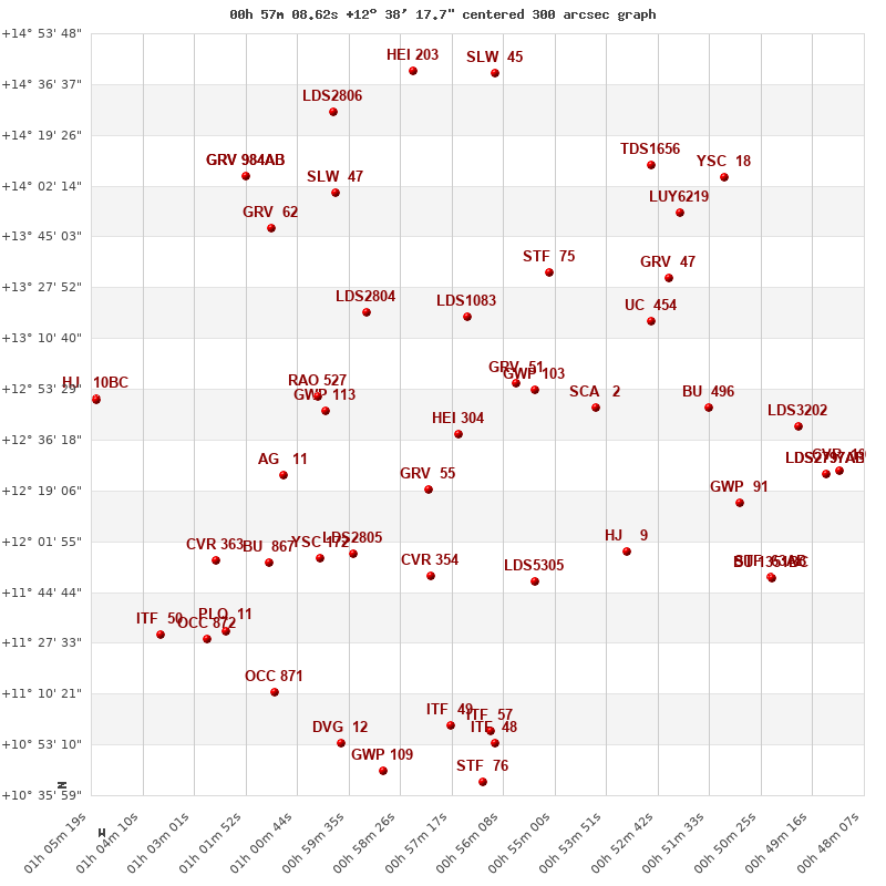
Click on the map to see the double of your interest.
Pass over with the mouse cursor to display the catalog designation.
|
| Show |
name |
coord_2000 |
discov# |
comp |
pa |
sep |
dist(') |
| Show |
|
00571+1239 |
HEI 304 |
|
87 |
0.8 |
|
| Show |
|
00578+1219 |
GRV 55 |
|
105 |
18.1 |
22 |
| Show |
|
00558+1255 |
GRV 51 |
|
240 |
60.3 |
26 |
| Show |
|
00554+1253 |
GWP 103 |
|
113 |
25.5 |
29 |
| Show |
|
00569+1318 |
LDS1083 |
|
154 |
3.1 |
40 |
| Show |
|
01001+1246 |
GWP 113 |
|
138 |
16.4 |
44 |
| Show |
|
00541+1247 |
SCA 2 |
|
251 |
14.5 |
46 |
| Show |
|
01003+1251 |
RAO 527 |
|
|
1.1 |
48 |
| Show |
|
00578+1150 |
CVR 354 |
|
67 |
14.1 |
50 |
| Show |
|
00592+1319 |
LDS2804 |
|
354 |
3.2 |
51 |
| Show |
|
00595+1158 |
LDS2805 |
|
51 |
50.2 |
54 |
| Show |
|
00554+1149 |
LDS5305 |
|
274 |
8.4 |
56 |
| Show |
|
01010+1224 |
AG 11 |
|
10 |
55.8 |
59 |
| Show |
|
01002+1156 |
YSC 172 |
|
131 |
0.0 |
62 |
| Show |
|
00551+1333 |
STF 75 |
|
273 |
5.2 |
63 |
| Show |
|
00534+1159 |
HJ 9 |
|
100 |
12.5 |
68 |
| Show |
|
00529+1316 |
UC 454 |
|
94 |
11.8 |
74 |
| Show |
|
01014+1155 |
BU 867 |
|
352 |
0.7 |
76 |
| Show |
|
00516+1247 |
BU 496 |
|
3 |
5.7 |
82 |
| Show |
|
00524+1331 |
GRV 47 |
|
153 |
22.9 |
87 |
| Show |
|
01025+1156 |
CVR 363 |
|
316 |
10.2 |
90 |
| Show |
|
00599+1400 |
SLW 47 |
|
159 |
45.8 |
91 |
| Show |
|
01013+1348 |
GRV 62 |
|
358 |
67.4 |
93 |
| Show |
|
00509+1215 |
GWP 91 |
|
95 |
24.4 |
95 |
| Show |
|
00573+1100 |
ITF 49 |
|
291 |
11.3 |
99 |
| Show |
|
00564+1058 |
ITF 57 |
|
302 |
9.7 |
101 |
| Show |
|
01023+1131 |
PLQ 11 |
|
3 |
9.9 |
102 |
| Show |
|
00522+1353 |
LUY6219 |
|
98 |
6.8 |
104 |
| Show |
|
00563+1053 |
ITF 48 |
|
126 |
2.1 |
106 |
| Show |
|
01012+1111 |
OCC 871 |
|
-1 |
0.1 |
107 |
| Show |
|
01027+1129 |
OCC 872 |
|
-1 |
0.1 |
108 |
| Show |
|
00529+1409 |
TDS1656 |
|
98 |
0.6 |
111 |
| Show |
|
00495+1241 |
LDS3202 |
|
283 |
3.0 |
111 |
| Show |
|
01019+1405 |
GRV 984 |
AB |
71 |
31.8 |
112 |
| Show |
|
01019+1405 |
SLW 49 |
AC |
281 |
178.9 |
112 |
| Show |
|
00598+1054 |
DVG 12 |
|
56 |
54.6 |
112 |
| Show |
|
00502+1150 |
STF 63 |
AB |
250 |
33.1 |
113 |
| Show |
|
00502+1150 |
BU 1351 |
BC |
318 |
118.3 |
114 |
| Show |
|
01000+1427 |
LDS2806 |
|
258 |
151.8 |
117 |
| Show |
|
00588+1044 |
GWP 109 |
|
212 |
14.5 |
117 |
| Show |
|
00566+1040 |
STF 76 |
|
199 |
3.0 |
119 |
| Show |
|
01052+1250 |
HJ 10 |
BC |
83 |
11.2 |
119 |
| Show |
|
01052+1250 |
HJ 10 |
AB |
314 |
5.0 |
119 |
| Show |
|
01052+1250 |
HJ 10 |
AC |
58 |
8.8 |
119 |
| Show |
|
01038+1130 |
ITF 50 |
|
353 |
11.1 |
119 |
| Show |
|
00489+1225 |
LDS2797 |
AB |
3 |
5.1 |
121 |
| Show |
|
00489+1225 |
LDS2797 |
Aa,Ab |
316 |
0.7 |
121 |
| Show |
|
00512+1405 |
YSC 18 |
|
241 |
0.1 |
123 |
| Show |
|
00563+1440 |
SLW 45 |
|
165 |
73.9 |
123 |
| Show |
|
00582+1442 |
HEI 203 |
|
82 |
1.2 |
124 |
| Show |
|
00487+1226 |
CVR 19 |
|
80 |
104.7 |
125 |
|
|
WDS 00571+1239 : COMPONENTS
00571+1239 A
| Componente originario normalizzato |
AB |
|
Coord arcsec 2000 |
005708.62+123817.7 |
|
Mag |
11.8 |
|
PmRA |
26.00 |
|
| PmDE |
6.0 |
|
Tycho2 |
0611-00686-1 |
|
| Tycho2 |
0611-00686-1 |
|
Pflag |
|
|
RAmdeg |
14.28594978 |
|
DEmdeg |
12.63827501 |
|
| PmRA |
25.5 |
|
PmDE |
5.8 |
|
E RAmdeg |
47 |
|
E DEmdeg |
35 |
|
| E pmRA |
1.5 |
|
E pmDE |
1.4 |
|
EpRAm |
1972.85 |
|
EpDEm |
1973.40 |
|
| Num |
6 |
|
Q RAmdeg |
0.6 |
|
Q DEmdeg |
0.7 |
|
Q pmRA |
0.5 |
|
| Q pmDE |
0.6 |
|
BTmag |
11.668 |
|
E BTmag |
0.104 |
|
VTmag |
10.996 |
|
| E VTmag |
0.098 |
|
Prox |
999 |
|
TYC |
T |
|
HIP |
|
|
| CCDM |
|
|
RAdeg |
14.28588806 |
|
DEdeg |
12.63827667 |
|
EpRA 1990 |
1.73 |
|
| EpDE 1990 |
1.74 |
|
E RAdeg |
59.9 |
|
E DEdeg |
70.8 |
|
Posflg |
|
|
| Corr |
0.0 |
|
00571+1239 B
| Componente originario normalizzato |
AB |
|
Coord arcsec 2000 |
005708.67+123817.7 |
|
Mag |
11.8 |
|
Calc coord |
yes |
|