06564-1016 RST 3475 BC
06h 56m 26.12s -10° 16' 26.0" P.A. 160.00 sep 0.4 mag 10.80,11.10
| Coord 2000 |
06564-1016 |
|
Discov num |
RST3475 |
|
Comp |
BC |
|
Coord arcsec 2000 |
06 56 26.12 -10 16 26.0 |
|
| Date first |
1938 |
|
Date last |
2018 |
|
Obs |
7 |
|
| Pa first |
174 |
|
Pa last |
160.1 |
|
P.A. Now (θ) |
160.1° |
|
| Sep first |
0.2 |
|
Sep last |
0.386 |
|
Sep. Now (ρ) |
0.386" |
|
| Mag pri |
10.80 |
|
Mag sec |
11.10 |
|
delta mag (ΔM) |
0.3 |
|
Spectral class |
|
|
| Pri motion ra |
-001 |
|
Sec motion ra |
|
|
| Pri motion dec |
-015 |
|
Sec motion dec |
|
|
| Notes |
|
|
Nature of this double is uncertain.
06564-1016 SYSTEM COMPONENTS
| Show |
name |
SAO |
coord |
wds_name |
last |
obs |
pa |
sep |
mag1 |
mag2 |
d_mag |
orb |
current |
| Show |
|
|
06 56 26 -10 16 08 |
RST 3475 A,BC |
2019 |
18 |
158 |
19.9 |
9.85 |
10.20 |
0.35 |
|
|
| Show |
|
|
06 56 26 -10 16 26 |
RST 3475 BC |
2018 |
7 |
160 |
0.4 |
10.80 |
11.10 |
0.30 |
|
<=== |
Triple system
4 estimated visually detectable stars in this system
OTHER CATALOGS AND DESIGNATIONS
| Constellation |
Monoceros |
|
Gaia DR2 |
3049392905758984192 |
|
WDS 06564-1016 RST 3475 BC : NOTES
No records found.
REFERENCES
| refcode |
metd |
author |
reference |
| Rst1933 |
T - |
Rossiter, R.A. |
1933MmRAS..65...27R |
| Rst1933 |
|
MemRAS 65, 27, 1933 |
|
| Rst1937 |
Ma - |
Rossiter, R.A. |
1937MmRAS..65...51R |
| Rst1937 |
|
MemRAS 65, 51, 1937 |
|
| Rst1943 |
Ma - |
Rossiter, R.A. |
1943POMic...8..133R |
| Rst1943 |
|
Pub. Univ. Michigan Obs. 8, 133, 1943 |
|
| Rst1944 |
- |
Rossiter, R.A. |
1944POMic...9....1R |
| Rst1944 |
|
Pub. Univ. Michigan Obs. 9, 1, 1944 |
|
| Rst1947 |
Ma - |
Rossiter, R.A. |
1947POMic...9....7R |
| Rst1947 |
|
Pub. Univ. Michigan Obs. 9, 7, 1947 |
|
| Rst1955 |
Ma j |
Rossiter, R.A. |
1955POMic..11....1R |
| Rst1955 |
+P+ |
Pub. Univ. Michigan Obs. 11, 1, 1955 |
|
| Rst1964 |
Ma - |
Rossiter, R.A. |
1964POMic...9...73R |
| Rst1964 |
|
Pub. Univ. Michigan Obs. 9, 73, 1964 |
|
WDS HISTORIC DATA
| coord_2000 |
discov_num |
comp |
epoch |
obs |
pa |
sep |
mag_pri |
mag_sec |
spectr |
notes |
coord_arcsec_2000 |
| 06564-1016 |
RST3475 |
BC |
1991 |
5 |
352 |
0.1 |
10.80 |
11.10 |
|
|
065626.12-101626.0 |
| 06564-1016 |
RST3475 |
BC |
2018 |
7 |
160 |
0.4 |
10.80 |
11.10 |
|
|
065626.12-101626.0 |
If you need more information about this double, apply for a
data request form to the WDS.
WDS 06564-1016 RST 3475 BC : VISUAL OBSERVATIONS REPORTS
No records found.
WDS 06564-1016 RST 3475 BC : MEASURES
No records found.
WDS 06564-1016 : VIRTUAL EYEPIECE
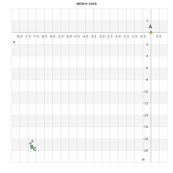
Click on the map to see the double of your interest.
Pass over with the mouse cursor to display the catalog designation.
|
|
WDS 06564-1016 : ALADIN DSS IMAGE @ 06h 56m 26.12s -10° 16' 26.0"
WDS 06564-1016 RST 3475 BC : NEIGHBORHOODS
|
|
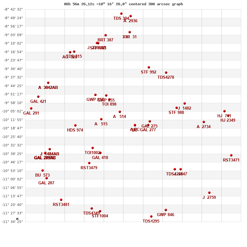
Click on the map to see the double of your interest.
Pass over with the mouse cursor to display the catalog designation.
|
| Show |
name |
coord_2000 |
discov# |
comp |
pa |
sep |
dist(') |
| Show |
|
06564-1016 |
RST3475 |
BC |
160 |
0.4 |
|
| Show |
|
06564-1016 |
RST3475 |
A,BC |
158 |
19.9 |
1 |
| Show |
|
06557-1017 |
GAL 277 |
|
147 |
6.1 |
12 |
| Show |
|
06556-1013 |
GAL 275 |
|
264 |
7.0 |
14 |
| Show |
|
06573-1005 |
A 514 |
|
103 |
1.5 |
18 |
| Show |
|
06584-1011 |
A 515 |
|
315 |
1.7 |
30 |
| Show |
|
06579-0955 |
TOI 898 |
|
37 |
1.3 |
31 |
| Show |
|
06581-0952 |
GWP 855 |
|
336 |
9.6 |
35 |
| Show |
|
06584-1038 |
GAL 418 |
|
179 |
15.4 |
38 |
| Show |
|
06540-1002 |
STF 988 |
|
265 |
33.2 |
39 |
| Show |
|
06589-1035 |
TOI1002 |
|
129 |
0.1 |
41 |
| Show |
|
06587-0952 |
GWP 857 |
|
190 |
8.7 |
43 |
| Show |
|
06536-0957 |
J 1482 |
|
351 |
8.3 |
47 |
| Show |
|
06556-0929 |
STF 992 |
|
300 |
13.9 |
49 |
| Show |
|
06541-1052 |
TDS4268 |
|
181 |
2.1 |
50 |
| Show |
|
06591-1047 |
RST3479 |
|
113 |
0.5 |
50 |
| Show |
|
06546-0934 |
TDS4278 |
|
130 |
0.6 |
51 |
| Show |
|
06599-1016 |
HDS 974 |
|
131 |
15.4 |
52 |
| Show |
|
06537-1051 |
J 2447 |
|
270 |
3.8 |
54 |
| Show |
|
06523-1014 |
A 2734 |
|
158 |
3.2 |
60 |
| Show |
|
06546-1125 |
GWP 846 |
|
118 |
49.9 |
74 |
| Show |
|
06586-0910 |
STF1003 |
|
321 |
3.9 |
74 |
| Show |
|
06587-0911 |
J 2768 |
AB |
54 |
5.9 |
75 |
| Show |
|
06587-0911 |
DAM 48 |
BC |
38 |
12.0 |
75 |
| Show |
|
06555-1130 |
TDS4295 |
|
19 |
2.4 |
76 |
| Show |
|
06585-1126 |
STF1004 |
|
89 |
20.5 |
76 |
| Show |
|
06567-0901 |
XMI 31 |
|
309 |
22.2 |
76 |
| Show |
|
07014-1036 |
J 1484 |
AB |
60 |
4.0 |
76 |
| Show |
|
07014-1036 |
DAM1197 |
AC |
38 |
9.0 |
76 |
| Show |
|
07014-1036 |
DAM1197 |
AD |
89 |
10.7 |
76 |
| Show |
|
06590-1124 |
TDS4349 |
|
114 |
2.2 |
77 |
| Show |
|
06582-0903 |
BRT 387 |
|
347 |
4.8 |
78 |
| Show |
|
06512-1005 |
HJ 741 |
|
233 |
15.0 |
79 |
| Show |
|
07000-0917 |
TDS 315 |
|
354 |
1.2 |
80 |
| Show |
|
07017-1039 |
GAL 289 |
BC |
60 |
8.0 |
81 |
| Show |
|
07017-1039 |
GAL 289 |
AB |
320 |
20.8 |
81 |
| Show |
|
07017-1039 |
RST3482 |
Aa,Ab |
277 |
1.4 |
81 |
| Show |
|
06510-1008 |
HJ 2349 |
|
286 |
15.2 |
81 |
| Show |
|
07002-0917 |
AG 328 |
|
183 |
6.5 |
82 |
| Show |
|
07015-0942 |
A 3042 |
AB |
92 |
0.2 |
83 |
| Show |
|
07015-0942 |
A 3042 |
AC |
80 |
11.1 |
83 |
| Show |
|
07015-0942 |
A 3042 |
AD |
345 |
8.8 |
83 |
| Show |
|
06528-1112 |
J 2759 |
|
33 |
8.6 |
85 |
| Show |
|
06508-1041 |
RST3471 |
|
359 |
0.4 |
87 |
| Show |
|
07021-0953 |
GAL 421 |
|
65 |
14.3 |
87 |
| Show |
|
07017-1100 |
GAL 287 |
|
11 |
6.6 |
88 |
| Show |
|
07018-1053 |
BU 573 |
|
311 |
0.8 |
88 |
| Show |
|
07008-1116 |
RST3481 |
|
263 |
0.6 |
88 |
| Show |
|
06567-0848 |
A 2936 |
|
66 |
0.5 |
89 |
| Show |
|
07024-1003 |
GAL 291 |
|
140 |
5.4 |
91 |
| Show |
|
06572-0846 |
TDS 304 |
|
213 |
1.3 |
92 |
|
|
WDS 06564-1016 : COMPONENTS
| |
A |
B |
| B |
pa=158.5°
sep=19.77"
| |
| C |
pa=158.6°
sep=20.16"
| pa=160.4°
sep=0.39"
|
06564-1016 A
| Coord arcsec 2000 |
065625.63-101607.6 |
|
Mag |
9.85 |
|
Spectral class |
K0 (yellow-orange) |
|
PmRA |
-2.00 |
|
| PmDE |
2.0 |
|
Tycho2 |
5384-01612-1 |
|
DM |
BD-10 1767 |
|
| Tycho2 |
5384-01612-1 |
|
Pflag |
|
|
RAmdeg |
104.10885532 |
|
DEmdeg |
-10.27390399 |
|
| PmRA |
0.4 |
|
PmDE |
3.6 |
|
E RAmdeg |
28 |
|
E DEmdeg |
31 |
|
| E pmRA |
1.5 |
|
E pmDE |
1.5 |
|
EpRAm |
1987.43 |
|
EpDEm |
1986.49 |
|
| Num |
4 |
|
Q RAmdeg |
1.1 |
|
Q DEmdeg |
0.4 |
|
Q pmRA |
1.1 |
|
| Q pmDE |
0.4 |
|
BTmag |
11.034 |
|
E BTmag |
0.060 |
|
VTmag |
10.199 |
|
| E VTmag |
0.041 |
|
Prox |
198 |
|
TYC |
T |
|
HIP |
|
|
| CCDM |
|
|
RAdeg |
104.10885417 |
|
DEdeg |
-10.27391222 |
|
EpRA 1990 |
1.77 |
|
| EpDE 1990 |
1.72 |
|
E RAdeg |
28.8 |
|
E DEdeg |
32.4 |
|
Posflg |
|
|
| Corr |
0.1 |
|
| Ccdm |
06564-1016 |
|
RComp |
|
|
Comp |
A |
|
Note1 |
|
|
| Note2 |
|
|
Discov num |
|
|
DRAs |
1.41 |
|
DDEs |
-4.2 |
|
| R dRAs |
12 |
|
Year |
|
|
Theta |
|
|
Rho |
|
|
| Obs |
3 |
|
Vmag |
9.5 |
|
Sp |
K0 |
|
PmNote |
|
|
| PmRA |
-46 |
|
PmDE |
74 |
|
Dm number |
-10 1767 |
|
Cat1 |
BD |
|
| Name2 |
152133 |
|
Cat2 |
SAO |
|
HD |
|
|
M HD |
|
|
| ADS BDS |
|
|
M ADS BDS |
|
|
N IDS |
|
|
IDS |
06517S1009A |
|
| HIC |
|
|
06564-1016 B
| Coord arcsec 2000 |
065626.12-101626.0 |
|
Mag |
10.8 |
|
PmRA |
-1.00 |
|
PmDE |
-15.0 |
|
| Calc delta mag |
0.95 |
|
| Ccdm |
06564-1016 |
|
RComp |
|
|
Comp |
B |
|
Note1 |
|
|
| Note2 |
|
|
Discov num |
RST3475 |
|
DRAs |
1.91 |
|
DDEs |
-21.7 |
|
| R dRAs |
10 |
|
Year |
1938 |
|
Theta |
158 |
|
Rho |
19.8 |
|
| Obs |
2 |
|
Vmag |
10.2 |
|
Sp |
|
|
PmNote |
* |
|
| PmRA |
-52 |
|
PmDE |
65 |
|
Dm number |
|
|
Cat1 |
|
|
| Name2 |
152135 |
|
Cat2 |
SAO |
|
HD |
|
|
M HD |
|
|
| ADS BDS |
|
|
M ADS BDS |
|
|
N IDS |
|
|
IDS |
06517S1009B |
|
| HIC |
|
|
06564-1016 C
| Coord arcsec 2000 |
065626.13-101626.4 |
|
Mag |
11.1 |
|
Calc delta mag |
1.25 |
|
Calc coord |
yes |
|
| Ccdm |
06564-1016 |
|
RComp |
B |
|
Comp |
C |
|
Note1 |
|
|
| Note2 |
|
|
Discov num |
RST3475 |
|
DRAs |
|
|
DDEs |
|
|
| R dRAs |
|
|
Year |
1951 |
|
Theta |
147 |
|
Rho |
0.2 |
|
| Obs |
3 |
|
Vmag |
10.5 |
|
Sp |
|
|
PmNote |
|
|
| PmRA |
|
|
PmDE |
|
|
Dm number |
|
|
Cat1 |
|
|
| Name2 |
|
|
Cat2 |
|
|
HD |
|
|
M HD |
|
|
| ADS BDS |
|
|
M ADS BDS |
|
|
N IDS |
|
|
IDS |
06517S1009C |
|
| HIC |
|
|