03494-1956 RST 2324
03h 49m 24.67s -19° 56' 08.1" P.A. 197.00 sep 0.3 mag 10.00,10.00 Sp G5
| Coord 2000 |
03494-1956 |
|
Discov num |
RST2324 |
|
Comp |
|
|
Coord arcsec 2000 |
03 49 24.67 -19 56 08.1 |
|
| Date first |
1935 |
|
Date last |
2018 |
|
Obs |
19 |
|
| Pa first |
208 |
|
Pa last |
197.2 |
|
P.A. Now (θ) |
193.4° |
|
| Sep first |
0.2 |
|
Sep last |
0.327 |
|
Sep. Now (ρ) |
0.316" |
|
| Mag pri |
10.00 |
|
Mag sec |
10.00 |
|
delta mag (ΔM) |
0 |
|
Spectral class |
G5 (yellow) |
|
| Pri motion ra |
+003 |
|
Sec motion ra |
|
|
| Pri motion dec |
+006 |
|
Sec motion dec |
|
|
| Notes |
O
(Orbital solution) |
|
This double is physical.
OTHER CATALOGS AND DESIGNATIONS
| Constellation |
Eridanus |
|
Tycho2 |
5884-00985-1 |
|
Gaia DR2 |
5094797546338595072 |
|
ORBITAL ELEMENTS
| Period (P) | 74.94y | |
Periastron (T) | 1995.01y | |
Semi-major axis (a) | 0.226a | |
| Eccentricity (e) | 0.597 | |
Inclination (i) | 130.9° | |
Longitude of periastron (ω) | 46.5° | |
| Node (Ω) | 35.4° | |
Notes | | |
Reference | Doc2019d | |
| Equinox | 2000 | |
Last observation | 2015 | |
Grade | 3 | (1=Definitive, 9=Indet.) |
| label |
theta |
rho |
| 2000 |
250.8 |
0.116 |
| 2001 |
242.7 |
0.136 |
| 2002 |
236.6 |
0.155 |
| 2003 |
231.8 |
0.172 |
| 2004 |
227.8 |
0.189 |
| 2005 |
224.5 |
0.204 |
| 2006 |
221.5 |
0.217 |
| 2007 |
219.0 |
0.230 |
| 2008 |
216.6 |
0.241 |
| 2009 |
214.5 |
0.251 |
| 2010 |
212.5 |
0.261 |
| 2011 |
210.7 |
0.269 |
| 2012 |
209.0 |
0.277 |
| 2013 |
207.3 |
0.283 |
| 2014 |
205.8 |
0.289 |
| 2015 |
204.2 |
0.295 |
| 2016 |
202.8 |
0.299 |
| 2017 |
201.4 |
0.303 |
| 2018 |
200.0 |
0.307 |
| 2019 |
198.6 |
0.310 |
| 2020 |
197.3 |
0.312 |
| 2021 |
196.0 |
0.314 |
| 2022 |
194.7 |
0.315 |
| 2023 |
193.4 |
0.316 |
| 2024 |
192.1 |
0.316 |
| 2025 |
190.8 |
0.316 |
| 2026 |
189.5 |
0.315 |
| 2027 |
188.2 |
0.314 |
| 2028 |
186.9 |
0.313 |
| 2029 |
185.6 |
0.311 |
| 2030 |
184.2 |
0.309 |
|
|
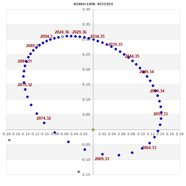
Note: Theta is PA, Rho is Sep. For yearly orbits, data refer to Jan 1st.
|
|
|
|
|
|
|
|
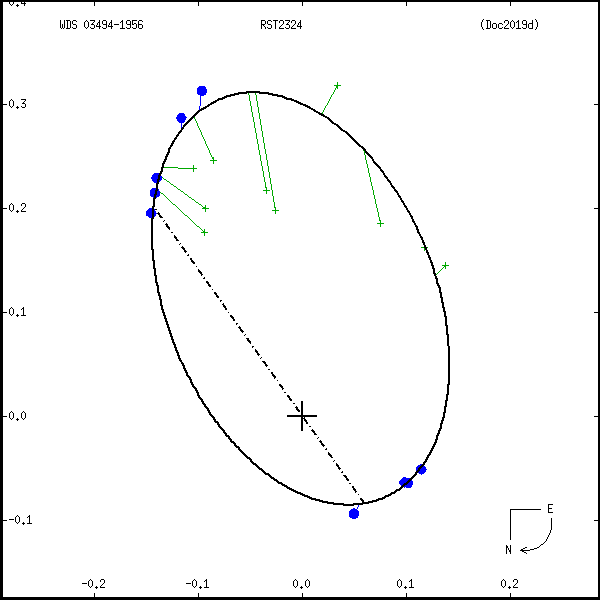
Measures: green=micrometric, blue=interferometric, purple=photographic |
|
WDS 03494-1956 RST 2324 : NOTES
No records found.
REFERENCES
| refcode |
metd |
author |
reference |
| Doc2019d |
orb - |
Docobo, J.A. & Campo, P. |
2019IAUDS.198S...1C |
| Doc2019d |
|
Inf. Circ. 198, 1, 2019 |
|
DISCOVERER
| idgroup |
discov |
author |
| 1 |
RST |
Rossiter, R.A. |
WDS HISTORIC DATA
| coord_2000 |
discov_num |
comp |
epoch |
obs |
pa |
sep |
mag_pri |
mag_sec |
spectr |
notes |
coord_arcsec_2000 |
| 03494-1956 |
RST2324 |
|
1993 |
14 |
28 |
0.1 |
10.00 |
10.00 |
G5 |
O |
034924.67-195608.1 |
| 03494-1956 |
RST2324 |
|
2008 |
15 |
217 |
0.2 |
10.00 |
10.00 |
G5 |
O |
034924.67-195608.1 |
| 03494-1956 |
RST2324 |
|
2010 |
16 |
214 |
0.3 |
10.00 |
10.00 |
G5 |
O |
034924.67-195608.1 |
| 03494-1956 |
RST2324 |
|
2011 |
17 |
212 |
0.3 |
10.00 |
10.00 |
G5 |
O |
034924.67-195608.1 |
| 03494-1956 |
RST2324 |
|
2015 |
18 |
202 |
0.3 |
10.00 |
10.00 |
G5 |
O |
034924.67-195608.1 |
| 03494-1956 |
RST2324 |
|
2018 |
19 |
197 |
0.3 |
10.00 |
10.00 |
G5 |
O |
034924.67-195608.1 |
If you need more information about this double, apply for a
data request form to the WDS.
WDS 03494-1956 RST 2324 : VISUAL OBSERVATIONS REPORTS
No records found.
WDS 03494-1956 RST 2324 : MEASURES
No records found.
WDS 03494-1956 : VIRTUAL EYEPIECE
Click on the map to see the double of your interest.
Pass over with the mouse cursor to display the catalog designation.
|
|
WDS 03494-1956 : ALADIN DSS IMAGE @ 03h 49m 24.67s -19° 56' 08.1"
WDS 03494-1956 RST 2324 : NEIGHBORHOODS
|
|
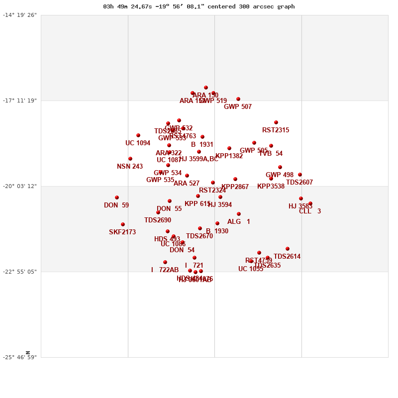
Click on the map to see the double of your interest.
Pass over with the mouse cursor to display the catalog designation.
|
| Show |
name |
coord_2000 |
discov# |
comp |
pa |
sep |
dist(') |
| Show |
|
03494-1956 |
RST2324 |
|
197 |
0.3 |
|
| Show |
|
03484-2025 |
HJ 3594 |
|
113 |
11.0 |
33 |
| Show |
|
03514-2023 |
KPP 615 |
|
80 |
5.6 |
39 |
| Show |
|
03464-1949 |
KPP2867 |
|
238 |
1.7 |
43 |
| Show |
|
03528-1942 |
ARA 527 |
|
131 |
6.5 |
51 |
| Show |
|
03512-1855 |
HJ 3599 |
A,BC |
73 |
12.6 |
67 |
| Show |
|
03512-1855 |
B 684 |
BC |
133 |
0.4 |
67 |
| Show |
|
03472-1847 |
KPP1382 |
|
3 |
10.4 |
76 |
| Show |
|
03459-2059 |
ALG 1 |
|
293 |
5.6 |
80 |
| Show |
|
03488-2118 |
B 1930 |
|
264 |
1.0 |
83 |
| Show |
|
03551-2032 |
DON 55 |
|
129 |
1.0 |
89 |
| Show |
|
03553-1921 |
GWP 534 |
|
15 |
10.1 |
90 |
| Show |
|
03508-1824 |
B 1931 |
|
266 |
2.7 |
94 |
| Show |
|
03511-2128 |
TDS2670 |
|
93 |
0.5 |
95 |
| Show |
|
03563-1935 |
GWP 535 |
|
63 |
22.9 |
99 |
| Show |
|
03551-1855 |
UC 1087 |
|
253 |
10.3 |
101 |
| Show |
|
03417-1948 |
KPP3538 |
|
158 |
1.9 |
110 |
| Show |
|
03551-1841 |
ARA 322 |
|
280 |
6.1 |
111 |
| Show |
|
03440-1836 |
GWP 505 |
|
184 |
108.2 |
112 |
| Show |
|
03566-2056 |
TDS2690 |
|
305 |
0.5 |
118 |
| Show |
|
03533-1807 |
RST4763 |
|
285 |
0.6 |
123 |
| Show |
|
03554-2134 |
HDS 493 |
|
165 |
0.8 |
129 |
| Show |
|
03547-1811 |
GWP 533 |
|
87 |
31.0 |
129 |
| Show |
|
03405-1925 |
GWP 498 |
|
317 |
25.0 |
130 |
| Show |
|
03546-2144 |
UC 1086 |
|
126 |
44.6 |
130 |
| Show |
|
03417-1842 |
TVB 54 |
|
153 |
1.6 |
132 |
| Show |
|
03534-2156 |
DON 54 |
|
356 |
0.7 |
133 |
| Show |
|
03539-1751 |
GWP 532 |
|
147 |
15.1 |
141 |
| Show |
|
03553-1758 |
TDS2685 |
|
102 |
0.5 |
146 |
| Show |
|
03517-2227 |
I 721 |
|
216 |
4.0 |
155 |
| Show |
|
04003-1908 |
NSN 243 |
|
182 |
3.1 |
161 |
| Show |
|
03379-1941 |
TDS2607 |
|
78 |
0.9 |
164 |
| Show |
|
03433-2217 |
RST4759 |
|
231 |
0.1 |
165 |
| Show |
|
03377-2028 |
HJ 3583 |
|
87 |
12.0 |
168 |
| Show |
|
03592-1821 |
UC 1094 |
|
23 |
11.5 |
169 |
| Show |
|
03411-1756 |
RST2315 |
|
145 |
1.8 |
169 |
| Show |
|
03443-2234 |
UC 1055 |
|
14 |
24.2 |
174 |
| Show |
|
03461-1708 |
GWP 507 |
|
189 |
24.0 |
175 |
| Show |
|
03509-2254 |
UC 1076 |
|
13 |
78.5 |
180 |
| Show |
|
03493-1656 |
GWP 519 |
|
7 |
55.1 |
180 |
| Show |
|
04020-2026 |
DON 59 |
|
42 |
1.9 |
181 |
| Show |
|
03422-2227 |
TDS2635 |
|
245 |
0.5 |
182 |
| Show |
|
03524-2253 |
HDS 484 |
|
334 |
2.5 |
182 |
| Show |
|
03517-2256 |
HJ 3601 |
AB |
300 |
10.6 |
183 |
| Show |
|
03557-2236 |
I 722 |
AB |
87 |
4.1 |
183 |
| Show |
|
03557-2236 |
I 722 |
BC |
22 |
8.0 |
183 |
| Show |
|
03520-1656 |
ARA 151 |
|
119 |
5.2 |
184 |
| Show |
|
04012-2120 |
SKF2173 |
|
134 |
29.3 |
186 |
| Show |
|
03365-2038 |
CLL 3 |
|
206 |
42.5 |
187 |
| Show |
|
03503-1646 |
ARA 150 |
|
133 |
10.9 |
191 |
| Show |
|
03395-2209 |
TDS2614 |
|
308 |
0.1 |
192 |
|
|
WDS 03494-1956 : COMPONENTS
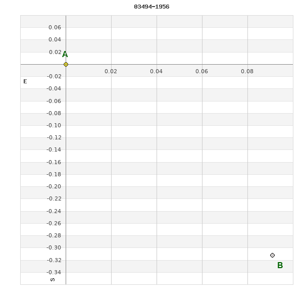
03494-1956 A
| Componente originario normalizzato |
AB |
|
Coord arcsec 2000 |
034924.67-195608.1 |
|
Mag |
10 |
|
Spectral class |
G5 (yellow) |
|
| PmRA |
3.00 |
|
PmDE |
6.0 |
|
Tycho2 |
5884-00985-1 |
|
| Tycho2 |
5884-00985-1 |
|
Pflag |
|
|
RAmdeg |
57.35288774 |
|
DEmdeg |
-19.93559684 |
|
| PmRA |
-3.5 |
|
PmDE |
16.2 |
|
E RAmdeg |
18 |
|
E DEmdeg |
22 |
|
| E pmRA |
2.0 |
|
E pmDE |
2.1 |
|
EpRAm |
1989.83 |
|
EpDEm |
1989.37 |
|
| Num |
7 |
|
Q RAmdeg |
0.7 |
|
Q DEmdeg |
1.2 |
|
Q pmRA |
0.7 |
|
| Q pmDE |
1.1 |
|
BTmag |
10.353 |
|
E BTmag |
0.040 |
|
VTmag |
9.504 |
|
| E VTmag |
0.028 |
|
Prox |
999 |
|
TYC |
T |
|
HIP |
|
|
| CCDM |
|
|
RAdeg |
57.35289750 |
|
DEdeg |
-19.93563639 |
|
EpRA 1990 |
1.68 |
|
| EpDE 1990 |
1.60 |
|
E RAdeg |
18.7 |
|
E DEdeg |
22.8 |
|
Posflg |
|
|
| Corr |
0.0 |
|
| Ccdm |
03494-1956 |
|
RComp |
|
|
Comp |
A |
|
Note1 |
|
|
| Note2 |
|
|
Discov num |
|
|
DRAs |
0.63 |
|
DDEs |
-8.3 |
|
| R dRAs |
10 |
|
Year |
|
|
Theta |
|
|
Rho |
|
|
| Obs |
2 |
|
Vmag |
10.0 |
|
Sp |
G5 |
|
PmNote |
* |
|
| PmRA |
-6 |
|
PmDE |
9 |
|
Dm number |
-20 716 |
|
Cat1 |
BD |
|
| Name2 |
168863 |
|
Cat2 |
SAO |
|
HD |
|
|
M HD |
|
|
| ADS BDS |
|
|
M ADS BDS |
|
|
N IDS |
|
|
IDS |
03450S2014A |
|
| HIC |
|
|
03494-1956 B
| Componente originario normalizzato |
AB |
|
Coord arcsec 2000 |
034924.66-195608.4 |
|
Mag |
10 |
|
Calc coord |
yes |
|
| Ccdm |
03494-1956 |
|
RComp |
|
|
Comp |
B |
|
Note1 |
|
|
| Note2 |
|
|
Discov num |
RST2324 |
|
DRAs |
|
|
DDEs |
|
|
| R dRAs |
|
|
Year |
1951 |
|
Theta |
189 |
|
Rho |
0.2 |
|
| Obs |
4 |
|
Vmag |
10.0 |
|
Sp |
|
|
PmNote |
|
|
| PmRA |
|
|
PmDE |
|
|
Dm number |
|
|
Cat1 |
|
|
| Name2 |
|
|
Cat2 |
|
|
HD |
|
|
M HD |
|
|
| ADS BDS |
|
|
M ADS BDS |
|
|
N IDS |
|
|
IDS |
03450S2014B |
|
| HIC |
|
|