03005+3934 A 1530 (HD 18567)
03h 00m 31.19s +39° 34' 21.3" P.A. 76.00 sep 0.3 mag 9.29,10.11 Sp F0 dist. 193.42 pc (630.94 l.y.)
| Coord 2000 |
03005+3934 |
|
Discov num |
A 1530 |
|
Comp |
|
|
Coord arcsec 2000 |
03 00 31.19 +39 34 21.3 |
|
| Date first |
1907 |
|
Date last |
2008 |
|
Obs |
20 |
|
| Pa first |
263 |
|
Pa last |
76.4 |
|
P.A. Now (θ) |
76.4° |
|
| Sep first |
0.4 |
|
Sep last |
0.274 |
|
Sep. Now (ρ) |
0.274" |
|
| Mag pri |
9.29 |
|
Mag sec |
10.11 |
|
delta mag (ΔM) |
0.82 |
|
Spectral class |
F0 (yellow-white) |
|
| Pri motion ra |
+010 |
|
Sec motion ra |
|
|
| Pri motion dec |
-004 |
|
Sec motion dec |
|
|
| Notes |
O
(Orbital solution) |
|
This double is physical.
OTHER CATALOGS AND DESIGNATIONS
| Name |
HD 18567 |
|
Constellation |
Perseus |
|
SAO |
56079 |
|
HIP |
14020 |
|
| Tycho2 |
2851-00260-1 |
|
Gaia DR2 |
143613192302150528 |
|
HD |
18567 |
|
ADS |
2273 |
|
| BD |
BD+38 609 |
|
Distance |
193.42 |
|
Distance ly |
630.94 |
|
ORBITAL ELEMENTS
| Period (P) | 127.8y | ± 7.2 |
Periastron (T) | 2020.7y | ± 3.5 |
Semi-major axis (a) | 0.4924a | ± 0.0038 |
| Eccentricity (e) | 0.739 | ± 0.053 |
Inclination (i) | 83.14° | ± 1.08 |
Longitude of periastron (ω) | 78.72° | ± 1.59 |
| Node (Ω) | 79.31° | ± 1.7 |
Notes | | |
Reference | Hrt2011a | |
| Equinox | 2000 | |
Last observation | 2008 | |
Grade | 4 | (1=Definitive, 9=Indet.) |
| label |
theta |
rho |
| 2000 |
64.8 |
0.240 |
| 2001 |
65.7 |
0.246 |
| 2002 |
66.6 |
0.251 |
| 2003 |
67.5 |
0.256 |
| 2004 |
68.3 |
0.260 |
| 2005 |
69.1 |
0.264 |
| 2006 |
69.9 |
0.267 |
| 2007 |
70.6 |
0.269 |
| 2008 |
71.4 |
0.270 |
| 2009 |
72.1 |
0.270 |
| 2010 |
72.9 |
0.269 |
| 2011 |
73.7 |
0.266 |
| 2012 |
74.4 |
0.262 |
| 2013 |
75.3 |
0.255 |
| 2014 |
76.1 |
0.246 |
| 2015 |
77.1 |
0.233 |
| 2016 |
78.2 |
0.215 |
| 2017 |
79.5 |
0.192 |
| 2018 |
81.3 |
0.160 |
| 2019 |
84.1 |
0.119 |
| 2020 |
90.8 |
0.068 |
| 2021 |
146.0 |
0.017 |
| 2022 |
243.7 |
0.057 |
| 2023 |
252.3 |
0.111 |
| 2024 |
255.4 |
0.158 |
| 2025 |
257.2 |
0.198 |
| 2026 |
258.4 |
0.232 |
| 2027 |
259.3 |
0.260 |
| 2028 |
260.0 |
0.284 |
| 2029 |
260.6 |
0.305 |
| 2030 |
261.2 |
0.323 |
|
|

Note: Theta is PA, Rho is Sep. For yearly orbits, data refer to Jan 1st.
|
|
|
|
|
|
|
|
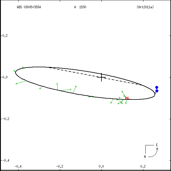
Measures: green=micrometric, blue=interferometric, purple=photographic |
|
WDS 03005+3934 A 1530 (HD 18567) : NOTES
No records found.
REFERENCES
| refcode |
metd |
author |
reference |
| Hrt2011a |
Su j |
Hartkopf, W.I. & Mason, B.D. |
2011AJ....142...56H |
| Hrt2011a |
+orb |
AJ 142, 56, 2011 |
|
DISCOVERER
| idgroup |
discov |
author |
| 1 |
A |
Aitken, R.G. |
WDS HISTORIC DATA
| coord_2000 |
discov_num |
comp |
epoch |
obs |
pa |
sep |
mag_pri |
mag_sec |
spectr |
notes |
coord_arcsec_2000 |
| 03005+3934 |
A 1530 |
|
1991 |
18 |
51 |
0.2 |
9.29 |
10.11 |
F0 |
|
030031.19+393421.3 |
| 03005+3934 |
A 1530 |
|
2008 |
19 |
76 |
0.3 |
9.29 |
10.11 |
F0 |
|
030031.19+393421.3 |
If you need more information about this double, apply for a
data request form to the WDS.
WDS 03005+3934 A 1530 (HD 18567) : VISUAL OBSERVATIONS REPORTS
No records found.
WDS 03005+3934 A 1530 (HD 18567) : MEASURES
No records found.
WDS 03005+3934 (HD 18567) : VIRTUAL EYEPIECE
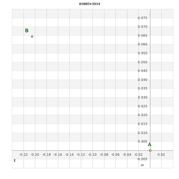
Click on the map to see the double of your interest.
Pass over with the mouse cursor to display the catalog designation.
|
|
WDS 03005+3934 (HD 18567) : ALADIN DSS IMAGE @ 03h 00m 31.19s +39° 34' 21.3"
WDS 03005+3934 A 1530 (HD 18567) : NEIGHBORHOODS
|
|
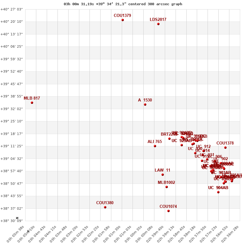
Click on the map to see the double of your interest.
Pass over with the mouse cursor to display the catalog designation.
|
| Show |
name |
coord_2000 |
discov# |
comp |
pa |
sep |
dist(') |
| Show |
|
03005+3934 |
A 1530 |
|
76 |
0.3 |
|
| Show |
|
02595+3916 |
BRT2202 |
|
71 |
3.1 |
23 |
| Show |
|
03001+3911 |
ALI 765 |
|
11 |
11.3 |
24 |
| Show |
|
02589+3916 |
UC 924 |
CD |
22 |
67.6 |
26 |
| Show |
|
02589+3916 |
UC 924 |
BC |
57 |
36.2 |
27 |
| Show |
|
02589+3916 |
UC 924 |
AB |
60 |
16.5 |
27 |
| Show |
|
02589+3916 |
UC 924 |
AC |
58 |
52.7 |
27 |
| Show |
|
02589+3912 |
UC 925 |
AB |
284 |
69.3 |
29 |
| Show |
|
02589+3912 |
UC 925 |
AC |
159 |
61.7 |
29 |
| Show |
|
02585+3912 |
UC 921 |
AB |
297 |
44.1 |
33 |
| Show |
|
02583+3914 |
UC 916 |
BC |
91 |
52.6 |
33 |
| Show |
|
02585+3912 |
UC 921 |
BC |
278 |
49.2 |
33 |
| Show |
|
02583+3914 |
UC 916 |
AB |
77 |
49.1 |
33 |
| Show |
|
02584+3907 |
UC 920 |
|
113 |
55.1 |
37 |
| Show |
|
02580+3909 |
UC 912 |
|
123 |
60.3 |
39 |
| Show |
|
02598+3856 |
LAW 11 |
|
17 |
0.9 |
40 |
| Show |
|
02581+3907 |
UC 914 |
|
101 |
26.8 |
40 |
| Show |
|
02581+3903 |
UC 915 |
|
67 |
43.4 |
43 |
| Show |
|
02579+3904 |
UC 911 |
|
44 |
43.7 |
44 |
| Show |
|
02599+4020 |
LDS2817 |
|
1 |
22.1 |
46 |
| Show |
|
02571+3910 |
COU1378 |
|
91 |
0.4 |
47 |
| Show |
|
02575+3903 |
UC 906 |
|
250 |
40.6 |
47 |
| Show |
|
02596+3849 |
MLB1002 |
|
89 |
6.7 |
47 |
| Show |
|
02577+3900 |
UC 910 |
|
234 |
48.9 |
48 |
| Show |
|
03014+4021 |
COU1379 |
|
77 |
0.7 |
49 |
| Show |
|
02576+3858 |
UC 908 |
BC |
302 |
70.2 |
50 |
| Show |
|
02576+3857 |
UC 909 |
BC |
225 |
49.5 |
50 |
| Show |
|
02573+3902 |
UC 902 |
|
229 |
54.0 |
50 |
| Show |
|
02576+3858 |
UC 908 |
AB |
113 |
75.1 |
50 |
| Show |
|
02576+3858 |
UC 908 |
AC |
52 |
12.2 |
50 |
| Show |
|
02576+3857 |
UC 909 |
AB |
349 |
64.7 |
51 |
| Show |
|
02576+3857 |
UC 909 |
AC |
301 |
55.7 |
51 |
| Show |
|
02572+3859 |
UC 900 |
AB |
217 |
37.6 |
53 |
| Show |
|
02572+3859 |
UC 900 |
AC |
126 |
23.1 |
53 |
| Show |
|
02572+3859 |
UC 900 |
BC |
68 |
44.4 |
53 |
| Show |
|
02573+3854 |
UC 903 |
AB |
93 |
73.7 |
56 |
| Show |
|
02573+3854 |
UC 903 |
AC |
17 |
40.0 |
56 |
| Show |
|
03053+3934 |
MLB 817 |
|
220 |
4.4 |
56 |
| Show |
|
02571+3852 |
UC 898 |
AB |
156 |
73.6 |
59 |
| Show |
|
02571+3852 |
UC 898 |
AC |
232 |
26.3 |
59 |
| Show |
|
02571+3852 |
UC 898 |
AD |
155 |
55.3 |
59 |
| Show |
|
02571+3852 |
UC 898 |
CD |
127 |
55.8 |
59 |
| Show |
|
02571+3852 |
UC 898 |
BC |
316 |
71.8 |
59 |
| Show |
|
02571+3852 |
UC 898 |
BD |
342 |
18.4 |
59 |
| Show |
|
02596+3835 |
COU1074 |
|
154 |
1.7 |
60 |
| Show |
|
02568+3853 |
UC 895 |
AB |
164 |
54.8 |
60 |
| Show |
|
03023+3837 |
COU1380 |
|
101 |
0.2 |
61 |
| Show |
|
02568+3853 |
UC 895 |
BD |
201 |
29.2 |
61 |
| Show |
|
02568+3853 |
UC 895 |
BC |
265 |
48.1 |
61 |
| Show |
|
02574+3846 |
UC 904 |
AB |
43 |
76.2 |
61 |
| Show |
|
02574+3846 |
UC 904 |
AC |
237 |
46.7 |
61 |
|
|
WDS 03005+3934 : COMPONENTS
03005+3934 A
| Componente originario normalizzato |
AB |
|
Name |
HD 18567 |
|
Coord arcsec 2000 |
030031.19+393421.3 |
|
Mag |
9.29 |
|
| Spectral class |
F0 (yellow-white) |
|
PmRA |
10.00 |
|
PmDE |
-4.0 |
|
SAO |
56079 |
|
| HIP |
14020 |
|
Tycho2 |
2851-00260-1 |
|
HD |
18567 |
|
BD |
BD+38 609 |
|
| Tycho2 |
2851-00260-1 |
|
Pflag |
|
|
RAmdeg |
45.12989344 |
|
DEmdeg |
39.57256377 |
|
| PmRA |
-17.9 |
|
PmDE |
-9.1 |
|
E RAmdeg |
12 |
|
E DEmdeg |
13 |
|
| E pmRA |
1.4 |
|
E pmDE |
1.4 |
|
EpRAm |
1990.28 |
|
EpDEm |
1989.79 |
|
| Num |
8 |
|
Q RAmdeg |
1.7 |
|
Q DEmdeg |
0.8 |
|
Q pmRA |
1.8 |
|
| Q pmDE |
0.9 |
|
BTmag |
9.226 |
|
E BTmag |
0.024 |
|
VTmag |
8.810 |
|
| E VTmag |
0.021 |
|
Prox |
999 |
|
TYC |
T |
|
HIP |
14020 |
|
| CCDM |
AS |
|
RAdeg |
45.12994528 |
|
DEdeg |
39.57258583 |
|
EpRA 1990 |
1.60 |
|
| EpDE 1990 |
1.39 |
|
E RAdeg |
11.7 |
|
E DEdeg |
13.6 |
|
Posflg |
P |
|
| Corr |
-0.1 |
|
| SAO |
56079 |
|
DelFlag |
|
|
RA1950 |
|
|
PmRA1950 |
-0.0022 |
|
| DE1950 |
|
|
PmDE1950 |
-0.004 |
|
Vmag |
8.5 |
|
SpType |
F0 |
|
| Double code |
|
|
Source |
5 |
|
CatNum |
348 |
|
DM |
BD+38 609 |
|
| DMcomp |
|
|
BDsup |
|
|
HD |
18567 |
|
M HD |
0 |
|
| GC |
|
|
RA1950rad |
0.77367346 |
|
DE1950rad |
0.68722203 |
|
PmRA2000 |
-0.0022 |
|
| PmDE2000 |
-0.007 |
|
| Catalog |
H |
|
HIP |
14020 |
|
Proxy |
H |
|
RAhms |
03 00 31.19 |
|
| DEdms |
+39 34 21.3 |
|
Vmag |
8.77 |
|
VarFlag |
|
|
R Vmag |
G |
|
| RAdeg |
45.13 |
|
DEdeg |
39.5726 |
|
AstroRef |
* |
|
Plx |
2.06 |
|
| CCDM |
03005+3934 |
|
N CCDM |
I |
|
Nsys |
1 |
|
Ncomp |
2 |
|
| MultFlag |
C |
|
Source |
S |
|
Qual |
B |
|
M HIP |
AS |
|
| Theta |
51 |
|
Rho |
0.158 |
|
HD |
18567 |
|
BD |
BD+38 609 |
|
| CD |
|
|
CP |
|
|
Dm number |
+38 609 |
|
VIred |
0.48 |
|
| SpType |
F0 |
|
R SpType |
|
|
Coord arcsec 2000 |
030031.19+393421.3 |
|
| HIP |
14020 |
|
Sn |
55 |
|
So |
3 |
|
Nc |
2 |
|
| RArad |
0.7876662673 |
|
DErad |
0.6906719984 |
|
Plx |
5.17 |
|
PmRA |
-21.65 |
|
| PmDE |
-5.26 |
|
E RArad |
1.21 |
|
E DErad |
1.28 |
|
E Plx |
2.01 |
|
| E pmRA |
1.46 |
|
E pmDE |
1.37 |
|
Hpmag |
8.8725 |
|
E Hpmag |
0.0039 |
|
| SHp |
0.025 |
|
VA |
0 |
|
BV |
0.41 |
|
E BV |
0.015 |
|
| VI |
0.48 |
|
| Ccdm |
03005+3934 |
|
RComp |
|
|
Comp |
A |
|
Note1 |
|
|
| Note2 |
|
|
Discov num |
|
|
DRAs |
1.32 |
|
DDEs |
20.8 |
|
| R dRAs |
12 |
|
Year |
|
|
Theta |
|
|
Rho |
|
|
| Obs |
2 |
|
Vmag |
9.3 |
|
Sp |
F0 |
|
PmNote |
|
|
| PmRA |
-46 |
|
PmDE |
-10 |
|
Dm number |
+38 609 |
|
Cat1 |
BD |
|
| Name2 |
+39 348 |
|
Cat2 |
AGK2/3 |
|
HD |
18567 |
|
M HD |
|
|
| ADS BDS |
A 2273 |
|
M ADS BDS |
|
|
N IDS |
|
|
IDS |
02541N3910A |
|
| HIC |
14020 |
|
03005+3934 B
| Componente originario normalizzato |
AB |
|
Coord arcsec 2000 |
030031.21+393421.4 |
|
Mag |
10.11 |
|
Calc delta mag |
0.82 |
|
| Calc coord |
yes |
|
| Ccdm |
03005+3934 |
|
RComp |
|
|
Comp |
B |
|
Note1 |
|
|
| Note2 |
|
|
Discov num |
A 1530 |
|
DRAs |
|
|
DDEs |
|
|
| R dRAs |
|
|
Year |
1954 |
|
Theta |
295 |
|
Rho |
0.2 |
|
| Obs |
6 |
|
Vmag |
9.7 |
|
Sp |
|
|
PmNote |
|
|
| PmRA |
|
|
PmDE |
|
|
Dm number |
|
|
Cat1 |
|
|
| Name2 |
|
|
Cat2 |
|
|
HD |
|
|
M HD |
|
|
| ADS BDS |
A 2273 |
|
M ADS BDS |
|
|
N IDS |
|
|
IDS |
02541N3910B |
|
| HIC |
14020 |
|