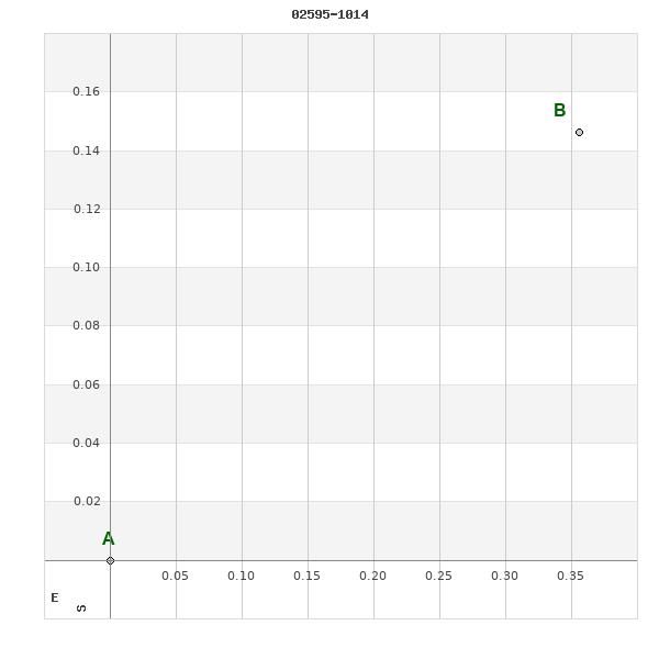
02595-1014 RST 4217
02h 59m 34.22s -10° 14' 18.6" P.A. 292.00 sep 0.4 mag 11.40,11.40
| Coord 2000 |
02595-1014 |
|
Discov num |
RST4217 |
|
Comp |
|
|
Coord arcsec 2000 |
02 59 34.22 -10 14 18.6 |
|
| Date first |
1939 |
|
Date last |
1977 |
|
Obs |
3 |
|
| Pa first |
114 |
|
Pa last |
292 |
|
P.A. Now (θ) |
292° |
|
| Sep first |
0.3 |
|
Sep last |
0.39 |
|
Sep. Now (ρ) |
0.39" |
|
| Mag pri |
11.40 |
|
Mag sec |
11.40 |
|
delta mag (ΔM) |
0 |
|
Spectral class |
|
|
| Pri motion ra |
+041 |
|
Sec motion ra |
|
|
| Pri motion dec |
-016 |
|
Sec motion dec |
|
|
| Notes |
|
|
Nature of this double is uncertain.
OTHER CATALOGS AND DESIGNATIONS
| Constellation |
Eridanus |
|
Tycho2 |
5290-00493-1 |
|
Gaia DR2 |
5161066112872016384 |
|
WDS 02595-1014 RST 4217 : NOTES
No records found.
REFERENCES
| refcode |
metd |
author |
reference |
| Rst1933 |
T - |
Rossiter, R.A. |
1933MmRAS..65...27R |
| Rst1933 |
|
MemRAS 65, 27, 1933 |
|
| Rst1937 |
Ma - |
Rossiter, R.A. |
1937MmRAS..65...51R |
| Rst1937 |
|
MemRAS 65, 51, 1937 |
|
| Rst1943 |
Ma - |
Rossiter, R.A. |
1943POMic...8..133R |
| Rst1943 |
|
Pub. Univ. Michigan Obs. 8, 133, 1943 |
|
| Rst1944 |
- |
Rossiter, R.A. |
1944POMic...9....1R |
| Rst1944 |
|
Pub. Univ. Michigan Obs. 9, 1, 1944 |
|
| Rst1947 |
Ma - |
Rossiter, R.A. |
1947POMic...9....7R |
| Rst1947 |
|
Pub. Univ. Michigan Obs. 9, 7, 1947 |
|
| Rst1955 |
Ma j |
Rossiter, R.A. |
1955POMic..11....1R |
| Rst1955 |
+P+ |
Pub. Univ. Michigan Obs. 11, 1, 1955 |
|
| Rst1964 |
Ma - |
Rossiter, R.A. |
1964POMic...9...73R |
| Rst1964 |
|
Pub. Univ. Michigan Obs. 9, 73, 1964 |
|
WDS HISTORIC DATA
| coord_2000 |
discov_num |
comp |
epoch |
obs |
pa |
sep |
mag_pri |
mag_sec |
spectr |
notes |
coord_arcsec_2000 |
| 02595-1014 |
RST4217 |
|
1977 |
3 |
292 |
0.4 |
11.40 |
11.40 |
|
|
025934.22-101418.6 |
If you need more information about this double, apply for a
data request form to the WDS.
WDS 02595-1014 RST 4217 : VISUAL OBSERVATIONS REPORTS
No records found.
WDS 02595-1014 RST 4217 : MEASURES
No records found.
WDS 02595-1014 : VIRTUAL EYEPIECE
Click on the map to see the double of your interest.
Pass over with the mouse cursor to display the catalog designation.
|
|
WDS 02595-1014 : ALADIN DSS IMAGE @ 02h 59m 34.22s -10° 14' 18.6"
WDS 02595-1014 RST 4217 : NEIGHBORHOODS
|
|
Click on the map to see the double of your interest.
Pass over with the mouse cursor to display the catalog designation.
|
| Show |
name |
coord_2000 |
discov# |
comp |
pa |
sep |
dist(') |
| Show |
|
02595-1014 |
RST4217 |
|
292 |
0.4 |
|
| Show |
|
02594-1016 |
A 2610 |
|
8 |
0.4 |
3 |
| Show |
|
03013-1020 |
A 2612 |
|
148 |
2.5 |
26 |
| Show |
|
03018-1042 |
RST4219 |
|
137 |
1.0 |
43 |
| Show |
|
02596-0925 |
A 455 |
AB |
315 |
3.4 |
50 |
| Show |
|
02596-0925 |
HJ 3545 |
AC |
68 |
44.2 |
50 |
| Show |
|
03002-1110 |
BRT2627 |
|
247 |
12.1 |
57 |
| Show |
|
02570-0930 |
KPP1263 |
|
151 |
9.7 |
59 |
| Show |
|
03036-1001 |
GWP 415 |
|
221 |
5.7 |
61 |
| Show |
|
02598-0913 |
JNN 22 |
|
321 |
0.6 |
62 |
| Show |
|
03003-1118 |
A 2611 |
|
263 |
0.1 |
65 |
| Show |
|
03001-0908 |
RST4218 |
|
209 |
2.3 |
67 |
| Show |
|
03035-1059 |
BU 1174 |
|
221 |
0.6 |
74 |
| Show |
|
03044-0951 |
RST4221 |
|
53 |
0.7 |
76 |
| Show |
|
02564-1133 |
LDS5405 |
|
220 |
11.7 |
92 |
| Show |
|
02544-0922 |
UC 850 |
|
109 |
38.7 |
94 |
| Show |
|
02532-1007 |
GWP 385 |
|
22 |
31.6 |
94 |
| Show |
|
02550-0841 |
GRV 995 |
|
153 |
25.7 |
107 |
| Show |
|
02548-0853 |
NSC 17 |
|
15 |
6.1 |
108 |
| Show |
|
02527-1105 |
GWP 384 |
|
222 |
43.9 |
114 |
| Show |
|
03053-0857 |
A 456 |
|
45 |
4.7 |
115 |
| Show |
|
02547-1147 |
UC 855 |
|
277 |
25.6 |
118 |
| Show |
|
02526-0914 |
NSN 248 |
|
206 |
4.4 |
120 |
| Show |
|
03044-1150 |
KPP1261 |
|
318 |
9.7 |
120 |
| Show |
|
02580-1215 |
UC 913 |
|
256 |
10.8 |
123 |
| Show |
|
02535-0851 |
RST4216 |
|
316 |
7.1 |
124 |
| Show |
|
02553-1209 |
GWP 395 |
|
254 |
21.9 |
131 |
| Show |
|
02558-0815 |
BRT 359 |
|
346 |
4.9 |
132 |
| Show |
|
02535-1151 |
GAL 79 |
|
354 |
5.7 |
132 |
| Show |
|
03059-1151 |
RST3377 |
|
113 |
2.6 |
134 |
| Show |
|
03088-0952 |
GWP 427 |
|
105 |
466.5 |
138 |
| Show |
|
02593-1234 |
A 2609 |
|
348 |
0.6 |
140 |
| Show |
|
03034-0804 |
LDS5409 |
|
143 |
171.7 |
141 |
| Show |
|
02557-1223 |
GAL 329 |
|
204 |
28.5 |
141 |
| Show |
|
03037-1225 |
RST3375 |
|
215 |
1.7 |
145 |
| Show |
|
03025-1232 |
UC 932 |
|
205 |
10.2 |
145 |
| Show |
|
02498-0955 |
KPP1176 |
|
316 |
9.2 |
146 |
| Show |
|
02590-0746 |
GRV 996 |
|
336 |
27.8 |
149 |
| Show |
|
02552-0800 |
EGN 2 |
|
84 |
10.2 |
150 |
| Show |
|
02531-1212 |
GAL 327 |
|
332 |
11.2 |
151 |
| Show |
|
02569-0749 |
BRT 360 |
|
348 |
4.1 |
151 |
| Show |
|
02573-1241 |
LDS5406 |
|
295 |
286.0 |
152 |
| Show |
|
02542-1225 |
GWP 387 |
|
346 |
11.7 |
153 |
| Show |
|
02493-1033 |
STF 315 |
|
166 |
1.2 |
153 |
| Show |
|
02496-0932 |
GWP 374 |
|
110 |
95.0 |
154 |
| Show |
|
02559-0751 |
SKF1942 |
|
354 |
11.4 |
154 |
| Show |
|
02571-1244 |
GWP 401 |
|
17 |
8.9 |
154 |
| Show |
|
03097-0935 |
MET 21 |
|
150 |
5.3 |
155 |
| Show |
|
02490-1029 |
BRG 16 |
AB |
216 |
0.6 |
157 |
| Show |
|
02490-1029 |
BRG 16 |
AC |
211 |
0.6 |
157 |
| Show |
|
02490-1029 |
BRG 16 |
BC |
258 |
0.2 |
157 |
|
|
WDS 02595-1014 : COMPONENTS
02595-1014 A
| Componente originario normalizzato |
AB |
|
Coord arcsec 2000 |
025934.22-101418.6 |
|
Mag |
11.4 |
|
PmRA |
41.00 |
|
| PmDE |
-16.0 |
|
Tycho2 |
5290-00493-1 |
|
DM |
BD-10 588 |
|
| Tycho2 |
5290-00493-1 |
|
Pflag |
|
|
RAmdeg |
44.89259180 |
|
DEmdeg |
-10.23850019 |
|
| PmRA |
40.6 |
|
PmDE |
-15.8 |
|
E RAmdeg |
27 |
|
E DEmdeg |
31 |
|
| E pmRA |
1.6 |
|
E pmDE |
1.7 |
|
EpRAm |
1981.37 |
|
EpDEm |
1977.77 |
|
| Num |
4 |
|
Q RAmdeg |
0.8 |
|
Q DEmdeg |
0.6 |
|
Q pmRA |
0.8 |
|
| Q pmDE |
0.6 |
|
BTmag |
11.592 |
|
E BTmag |
0.075 |
|
VTmag |
10.680 |
|
| E VTmag |
0.056 |
|
Prox |
999 |
|
TYC |
T |
|
HIP |
|
|
| CCDM |
|
|
RAdeg |
44.89250000 |
|
DEdeg |
-10.23846056 |
|
EpRA 1990 |
1.83 |
|
| EpDE 1990 |
1.72 |
|
E RAdeg |
34.9 |
|
E DEdeg |
44.5 |
|
Posflg |
|
|
| Corr |
-0.2 |
|
02595-1014 B
| Componente originario normalizzato |
AB |
|
Coord arcsec 2000 |
025934.20-101418.5 |
|
Mag |
11.4 |
|
Calc coord |
yes |
|