22107+0755 WOR 10
22h 10m 44.71s +07° 54' 32.9" P.A. 2.00 sep 1.0 mag 11.54,11.76 dist. 38.02 pc (124.02 l.y.)
| Coord 2000 |
22107+0755 |
|
Discov num |
WOR 10 |
|
Comp |
|
|
Coord arcsec 2000 |
22 10 44.71 +07 54 32.9 |
|
| Date first |
1959 |
|
Date last |
2018 |
|
Obs |
28 |
|
| Pa first |
157 |
|
Pa last |
2.4 |
|
P.A. Now (θ) |
2.4° |
|
| Sep first |
0.8 |
|
Sep last |
0.961 |
|
Sep. Now (ρ) |
0.961" |
|
| Mag pri |
11.54 |
|
Mag sec |
11.76 |
|
delta mag (ΔM) |
0.22 |
|
Spectral class |
|
|
| Pri motion ra |
+253 |
|
Sec motion ra |
|
|
| Pri motion dec |
+014 |
|
Sec motion dec |
|
|
| Notes |
O
(Orbital solution) |
|
This double is physical.
OTHER CATALOGS AND DESIGNATIONS
| Spectr |
M0 |
|
Constellation |
Pegasus |
|
HIP |
109480 |
|
Tycho2 |
1136-00702-1 |
|
| Gaia DR2 |
2722006206116795008 |
|
Distance |
38.02 |
|
Distance ly |
124.02 |
|
ORBITAL ELEMENTS
| Period (P) | 336y | |
Periastron (T) | 1971y | |
Semi-major axis (a) | 1.388a | |
| Eccentricity (e) | 0.412 | |
Inclination (i) | 119.5° | |
Longitude of periastron (ω) | 33.6° | |
| Node (Ω) | 154.7° | |
Notes | | |
Reference | Zir2014a | |
| Equinox | 2000 | |
Last observation | 2008 | |
Grade | 5 | (1=Definitive, 9=Indet.) |
| label |
theta |
rho |
| 2000 |
38.1 |
0.541 |
| 2001 |
35.0 |
0.558 |
| 2002 |
32.1 |
0.576 |
| 2003 |
29.4 |
0.595 |
| 2004 |
26.9 |
0.615 |
| 2005 |
24.5 |
0.636 |
| 2006 |
22.3 |
0.657 |
| 2007 |
20.2 |
0.678 |
| 2008 |
18.3 |
0.700 |
| 2009 |
16.4 |
0.722 |
| 2010 |
14.7 |
0.744 |
| 2011 |
13.1 |
0.766 |
| 2012 |
11.6 |
0.789 |
| 2013 |
10.1 |
0.811 |
| 2014 |
8.7 |
0.834 |
| 2015 |
7.5 |
0.856 |
| 2016 |
6.2 |
0.879 |
| 2017 |
5.1 |
0.901 |
| 2018 |
3.9 |
0.923 |
| 2019 |
2.9 |
0.946 |
| 2020 |
1.9 |
0.967 |
| 2021 |
0.9 |
0.989 |
| 2022 |
360.0 |
1.011 |
| 2023 |
359.1 |
1.032 |
| 2024 |
358.2 |
1.053 |
| 2025 |
357.4 |
1.074 |
| 2026 |
356.6 |
1.095 |
| 2027 |
355.9 |
1.115 |
| 2028 |
355.1 |
1.135 |
| 2029 |
354.4 |
1.155 |
| 2030 |
353.7 |
1.175 |
|
|
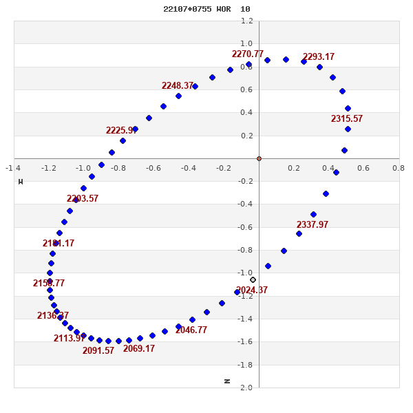
Note: Theta is PA, Rho is Sep. For yearly orbits, data refer to Jan 1st.
|
|
|
|
|
|
|
|
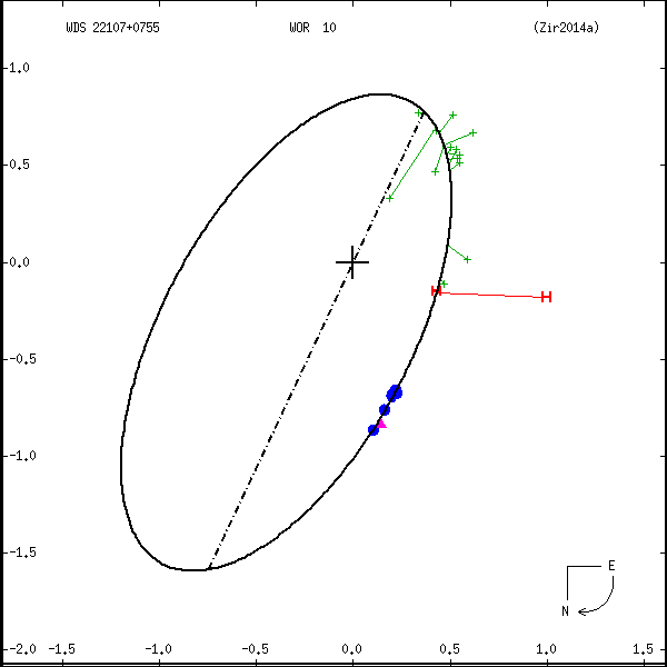
Measures: green=micrometric, blue=interferometric, purple=photographic |
|
WDS 22107+0755 WOR 10 : NOTES
No records found.
REFERENCES
| refcode |
metd |
author |
reference |
| Zir2014a |
orb - |
Zirm, H. |
2014IAUDS.182....1Z |
| Zir2014a |
|
Inf. Circ. 182, 1, 2014 |
|
DISCOVERER
| idgroup |
discov |
author |
| 1 |
WOR |
Worley, C.E. |
WDS HISTORIC DATA
| coord_2000 |
discov_num |
comp |
epoch |
obs |
pa |
sep |
mag_pri |
mag_sec |
spectr |
notes |
coord_arcsec_2000 |
| 22107+0755 |
WOR 10 |
|
1991 |
15 |
80 |
1.0 |
11.54 |
11.76 |
|
|
221044.56+075432.7 |
| 22107+0755 |
WOR 10 |
|
2007 |
17 |
18 |
0.7 |
11.54 |
11.76 |
|
D |
221044.56+075432.7 |
| 22107+0755 |
WOR 10 |
|
2008 |
19 |
16 |
0.7 |
11.54 |
11.76 |
|
D |
221044.56+075432.7 |
| 22107+0755 |
WOR 10 |
|
2013 |
20 |
10 |
0.9 |
11.54 |
11.76 |
|
O |
221044.56+075432.7 |
| 22107+0755 |
WOR 10 |
|
2014 |
21 |
187 |
0.9 |
11.54 |
11.76 |
|
O |
221044.56+075432.7 |
| 22107+0755 |
WOR 10 |
|
2018 |
25 |
2 |
1.0 |
11.54 |
11.76 |
|
O |
221044.71+075432.9 |
If you need more information about this double, apply for a
data request form to the WDS.
WDS 22107+0755 WOR 10 : VISUAL OBSERVATIONS REPORTS
No records found.
WDS 22107+0755 WOR 10 : MEASURES
No records found.
WDS 22107+0755 : VIRTUAL EYEPIECE

Click on the map to see the double of your interest.
Pass over with the mouse cursor to display the catalog designation.
|
|
WDS 22107+0755 : ALADIN DSS IMAGE @ 22h 10m 44.71s +07° 54' 32.9"
WDS 22107+0755 WOR 10 : NEIGHBORHOODS
|
|

Click on the map to see the double of your interest.
Pass over with the mouse cursor to display the catalog designation.
|
| Show |
name |
coord_2000 |
discov# |
comp |
pa |
sep |
dist(') |
| Show |
|
22107+0755 |
WOR 10 |
|
2 |
1.0 |
|
| Show |
|
22100+0757 |
STF2867 |
AB |
208 |
10.5 |
11 |
| Show |
|
22100+0757 |
ABH 159 |
AD |
219 |
95.5 |
11 |
| Show |
|
22100+0757 |
STF2867 |
BC |
247 |
6.3 |
11 |
| Show |
|
22098+0800 |
HJ 955 |
|
317 |
9.5 |
16 |
| Show |
|
22121+0748 |
UC 4678 |
|
303 |
23.8 |
22 |
| Show |
|
22116+0735 |
BRT2193 |
|
268 |
3.1 |
24 |
| Show |
|
22091+0807 |
ITF 1 |
|
64 |
18.7 |
28 |
| Show |
|
22122+0828 |
HDS3150 |
|
294 |
0.2 |
40 |
| Show |
|
22137+0743 |
BU 699 |
AB |
185 |
2.5 |
46 |
| Show |
|
22137+0743 |
BU 699 |
AC |
322 |
50.6 |
46 |
| Show |
|
22145+0759 |
STF2878 |
AB |
116 |
1.6 |
56 |
| Show |
|
22145+0759 |
STF2878 |
AC |
119 |
69.0 |
56 |
| Show |
|
22145+0759 |
STF2878 |
AD |
274 |
124.9 |
56 |
| Show |
|
22119+0654 |
BU 698 |
AB |
338 |
10.7 |
64 |
| Show |
|
22119+0654 |
BU 698 |
AC |
289 |
105.7 |
64 |
| Show |
|
22067+0734 |
GWP3124 |
|
48 |
12.7 |
64 |
| Show |
|
22063+0759 |
UC 4647 |
|
276 |
18.5 |
66 |
| Show |
|
22073+0842 |
CVR 258 |
|
127 |
32.9 |
71 |
| Show |
|
22060+0813 |
YSC 74 |
|
219 |
0.2 |
74 |
| Show |
|
22066+0653 |
SLW1261 |
|
345 |
71.3 |
88 |
| Show |
|
22167+0812 |
TDT3440 |
|
55 |
1.3 |
90 |
| Show |
|
22077+0913 |
HJ 3090 |
|
81 |
1.6 |
92 |
| Show |
|
22162+0841 |
J 3265 |
|
142 |
4.0 |
93 |
| Show |
|
22050+0838 |
OSO 168 |
AB |
329 |
13.4 |
96 |
| Show |
|
22050+0838 |
LDS4942 |
AC |
50 |
128.2 |
96 |
| Show |
|
22165+0841 |
J 2403 |
|
93 |
5.4 |
98 |
| Show |
|
22171+0822 |
HU 287 |
|
83 |
1.3 |
99 |
| Show |
|
22102+0612 |
VSP 57 |
|
11 |
0.2 |
103 |
| Show |
|
22117+0612 |
OSO 173 |
AB |
221 |
20.1 |
104 |
| Show |
|
22117+0612 |
OSO 173 |
AC |
231 |
26.2 |
104 |
| Show |
|
22172+0839 |
J 2404 |
|
46 |
6.3 |
106 |
| Show |
|
22173+0843 |
GRV 558 |
|
73 |
26.0 |
111 |
| Show |
|
22052+0911 |
HJ 3087 |
|
100 |
29.9 |
113 |
| Show |
|
22041+0657 |
GWP3119 |
|
9 |
14.6 |
115 |
| Show |
|
22173+0653 |
UC 4704 |
|
225 |
31.3 |
116 |
| Show |
|
22125+0602 |
HJ 3098 |
|
80 |
28.9 |
116 |
| Show |
|
22186+0827 |
OSO 175 |
|
197 |
4.9 |
122 |
| Show |
|
22035+0652 |
HJ 3084 |
|
53 |
15.1 |
125 |
| Show |
|
22122+0553 |
HJ 3097 |
BD |
323 |
7.7 |
125 |
| Show |
|
22122+0553 |
HJ 3097 |
AB |
38 |
20.2 |
126 |
| Show |
|
22122+0553 |
HJ 3097 |
AC |
333 |
26.9 |
126 |
| Show |
|
22187+0712 |
GRV 562 |
|
203 |
32.3 |
126 |
| Show |
|
22035+0649 |
HJ 3083 |
|
210 |
31.6 |
127 |
| Show |
|
22193+0800 |
J 179 |
|
311 |
3.8 |
127 |
| Show |
|
22192+0729 |
SLW1272 |
|
113 |
121.0 |
129 |
| Show |
|
22196+0740 |
BRT2194 |
|
223 |
3.4 |
133 |
| Show |
|
22095+0542 |
HWE 61 |
|
128 |
1.2 |
134 |
| Show |
|
22173+0612 |
CVR 937 |
|
341 |
14.3 |
142 |
| Show |
|
22130+0537 |
SLW1268 |
|
351 |
24.9 |
142 |
| Show |
|
22110+1020 |
UC 270 |
|
155 |
42.0 |
146 |
|
|
WDS 22107+0755 : COMPONENTS
22107+0755 A
| Componente originario normalizzato |
AB |
|
Coord arcsec 2000 |
221044.71+075432.9 |
|
Mag |
11.54 |
|
Spectral class |
M0 (red) |
|
| PmRA |
253.00 |
|
PmDE |
14.0 |
|
| Ccdm |
22107+0755 |
|
RComp |
|
|
Comp |
A |
|
Note1 |
|
|
| Note2 |
|
|
Discov num |
|
|
DRAs |
2.75 |
|
DDEs |
-26.3 |
|
| R dRAs |
65 |
|
Year |
|
|
Theta |
|
|
Rho |
|
|
| Obs |
2 |
|
Vmag |
11.3 |
|
Sp |
M0 |
|
PmNote |
* |
|
| PmRA |
241 |
|
PmDE |
65 |
|
Dm number |
|
|
Cat1 |
|
|
| Name2 |
|
|
Cat2 |
|
|
HD |
|
|
M HD |
|
|
| ADS BDS |
|
|
M ADS BDS |
|
|
N IDS |
|
|
IDS |
22057N0725A |
|
| HIC |
109480 |
|
22107+0755 B
| Componente originario normalizzato |
AB |
|
Coord arcsec 2000 |
221044.71+075433.9 |
|
Mag |
11.76 |
|
Calc delta mag |
0.22 |
|
| Calc coord |
yes |
|
| Ccdm |
22107+0755 |
|
RComp |
|
|
Comp |
B |
|
Note1 |
|
|
| Note2 |
|
|
Discov num |
WOR 10 |
|
DRAs |
|
|
DDEs |
|
|
| R dRAs |
|
|
Year |
1959 |
|
Theta |
157 |
|
Rho |
0.8 |
|
| Obs |
1 |
|
Vmag |
12.5 |
|
Sp |
|
|
PmNote |
|
|
| PmRA |
|
|
PmDE |
|
|
Dm number |
|
|
Cat1 |
|
|
| Name2 |
|
|
Cat2 |
|
|
HD |
|
|
M HD |
|
|
| ADS BDS |
|
|
M ADS BDS |
|
|
N IDS |
|
|
IDS |
22057N0725B |
|
| HIC |
109480 |
|