22077+2622 COU 537
22h 07m 40.20s +26° 21' 35.8" P.A. 328.00 sep 0.2 mag 8.60,8.80 Sp G0
| Coord 2000 |
22077+2622 |
|
Discov num |
COU 537 |
|
Comp |
|
|
Coord arcsec 2000 |
22 07 40.20 +26 21 35.8 |
|
| Date first |
1970 |
|
Date last |
2013 |
|
Obs |
40 |
|
| Pa first |
339 |
|
Pa last |
327.6 |
|
P.A. Now (θ) |
354.9° |
|
| Sep first |
0.3 |
|
Sep last |
0.241 |
|
Sep. Now (ρ) |
0.234" |
|
| Mag pri |
8.60 |
|
Mag sec |
8.80 |
|
delta mag (ΔM) |
0.2 |
|
Spectral class |
G0 (yellow) |
|
| Pri motion ra |
-017 |
|
Sec motion ra |
|
|
| Pri motion dec |
-020 |
|
Sec motion dec |
|
|
| Notes |
O
(Orbital solution) |
|
This double is physical.
OTHER CATALOGS AND DESIGNATIONS
| Constellation |
Pegasus |
|
Tycho2 |
2212-01321-1 |
|
ORBITAL ELEMENTS
| Period (P) | 47.43y | |
Periastron (T) | 1993.7y | |
Semi-major axis (a) | 0.185a | |
| Eccentricity (e) | 0.595 | |
Inclination (i) | 35.1° | |
Longitude of periastron (ω) | 89.1° | |
| Node (Ω) | 69.3° | |
Notes | | |
Reference | Doc2012g | |
| Equinox | 2000 | |
Last observation | 2008 | |
Grade | 3 | (1=Definitive, 9=Indet.) |
| label |
theta |
rho |
| 2000 |
273.2 |
0.162 |
| 2001 |
279.3 |
0.174 |
| 2002 |
284.7 |
0.184 |
| 2003 |
289.5 |
0.192 |
| 2004 |
293.9 |
0.200 |
| 2005 |
298.1 |
0.207 |
| 2006 |
301.9 |
0.213 |
| 2007 |
305.6 |
0.218 |
| 2008 |
309.1 |
0.223 |
| 2009 |
312.5 |
0.227 |
| 2010 |
315.8 |
0.230 |
| 2011 |
319.0 |
0.233 |
| 2012 |
322.1 |
0.236 |
| 2013 |
325.1 |
0.238 |
| 2014 |
328.1 |
0.239 |
| 2015 |
331.1 |
0.240 |
| 2016 |
334.1 |
0.241 |
| 2017 |
337.0 |
0.241 |
| 2018 |
339.9 |
0.241 |
| 2019 |
342.9 |
0.241 |
| 2020 |
345.8 |
0.240 |
| 2021 |
348.8 |
0.238 |
| 2022 |
351.8 |
0.237 |
| 2023 |
354.9 |
0.234 |
| 2024 |
358.0 |
0.232 |
| 2025 |
1.3 |
0.229 |
| 2026 |
4.6 |
0.225 |
| 2027 |
8.0 |
0.221 |
| 2028 |
11.6 |
0.216 |
| 2029 |
15.4 |
0.210 |
| 2030 |
19.3 |
0.204 |
|
|
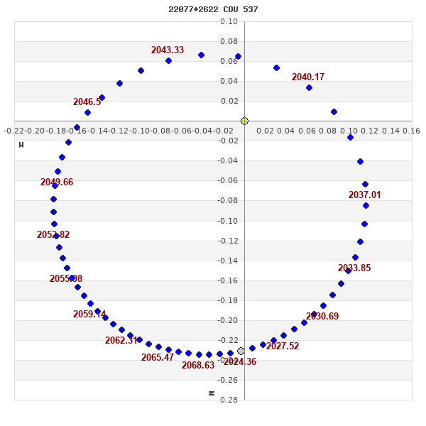
Note: Theta is PA, Rho is Sep. For yearly orbits, data refer to Jan 1st.
|
|
|
|
|
|
|
|
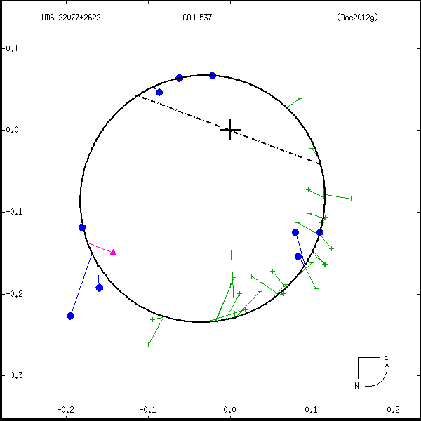
Measures: green=micrometric, blue=interferometric, purple=photographic |
|
WDS 22077+2622 COU 537 : NOTES
No records found.
REFERENCES
| refcode |
metd |
author |
reference |
| Doc2012g |
orb - |
Docobo, J.A. & Ling, J.F. |
2012IAUDS.177R...1D |
| Doc2012g |
|
Inf. Circ. 177, 1, 2012 |
|
DISCOVERER
| idgroup |
discov |
author |
| 1 |
COU |
Couteau, P. |
WDS HISTORIC DATA
| coord_2000 |
discov_num |
comp |
epoch |
obs |
pa |
sep |
mag_pri |
mag_sec |
spectr |
notes |
coord_arcsec_2000 |
| 22077+2622 |
COU 537 |
|
1996 |
33 |
242 |
0.1 |
8.60 |
8.80 |
G0 |
NO |
220740.20+262135.8 |
| 22077+2622 |
COU 537 |
|
2006 |
34 |
303 |
0.2 |
8.60 |
8.80 |
G0 |
NO |
220740.20+262135.8 |
| 22077+2622 |
COU 537 |
|
2007 |
35 |
136 |
0.2 |
8.60 |
8.80 |
G0 |
NO |
220740.20+262135.8 |
| 22077+2622 |
COU 537 |
|
2008 |
36 |
319 |
0.3 |
8.60 |
8.80 |
G0 |
NO |
220740.20+262135.8 |
| 22077+2622 |
COU 537 |
|
2009 |
37 |
320 |
0.3 |
8.60 |
8.80 |
G0 |
NO |
220740.20+262135.8 |
| 22077+2622 |
COU 537 |
|
2010 |
39 |
325 |
0.3 |
8.60 |
8.80 |
G0 |
O |
220740.20+262135.8 |
| 22077+2622 |
COU 537 |
|
2013 |
40 |
328 |
0.2 |
8.60 |
8.80 |
G0 |
O |
220740.20+262135.8 |
If you need more information about this double, apply for a
data request form to the WDS.
WDS 22077+2622 COU 537 : VISUAL OBSERVATIONS REPORTS
No records found.
WDS 22077+2622 COU 537 : MEASURES
No records found.
WDS 22077+2622 : VIRTUAL EYEPIECE
Click on the map to see the double of your interest.
Pass over with the mouse cursor to display the catalog designation.
|
|
WDS 22077+2622 : ALADIN DSS IMAGE @ 22h 07m 40.20s +26° 21' 35.8"
WDS 22077+2622 COU 537 : NEIGHBORHOODS
|
|
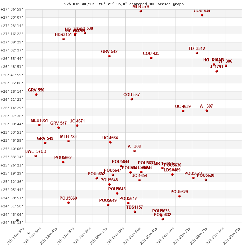
Click on the map to see the double of your interest.
Pass over with the mouse cursor to display the catalog designation.
|
| Show |
name |
coord_2000 |
discov# |
comp |
pa |
sep |
dist(') |
| Show |
|
22077+2622 |
COU 537 |
|
328 |
0.2 |
|
| Show |
|
22063+2656 |
COU 435 |
|
12 |
1.4 |
39 |
| Show |
|
22091+2545 |
UC 4664 |
|
28 |
8.3 |
42 |
| Show |
|
22092+2657 |
GRV 542 |
|
10 |
30.3 |
42 |
| Show |
|
22075+2538 |
A 308 |
|
312 |
0.2 |
44 |
| Show |
|
22041+2612 |
UC 4639 |
|
343 |
11.0 |
49 |
| Show |
|
22114+2600 |
UC 4671 |
|
27 |
39.9 |
56 |
| Show |
|
22084+2525 |
POU5644 |
|
322 |
16.1 |
58 |
| Show |
|
22066+2524 |
POU5637 |
|
107 |
13.2 |
59 |
| Show |
|
22077+2521 |
POU5641 |
|
238 |
8.2 |
62 |
| Show |
|
22070+2521 |
STT 596 |
AB |
229 |
127.2 |
62 |
| Show |
|
22070+2521 |
PTI 1 |
Aa,Ab |
173 |
0.0 |
62 |
| Show |
|
22055+2524 |
FMR 168 |
AB |
243 |
75.0 |
65 |
| Show |
|
22090+2518 |
POU5647 |
|
110 |
20.9 |
66 |
| Show |
|
22071+2514 |
UC 4654 |
|
354 |
73.0 |
69 |
| Show |
|
22120+2546 |
MLB 723 |
|
339 |
2.3 |
69 |
| Show |
|
22025+2612 |
A 307 |
|
125 |
0.4 |
71 |
| Show |
|
22048+2523 |
POU5630 |
|
58 |
13.9 |
71 |
| Show |
|
22109+2717 |
COU 538 |
|
112 |
0.1 |
71 |
| Show |
|
22032+2701 |
TDT3312 |
|
197 |
2.5 |
72 |
| Show |
|
22127+2557 |
GRV 547 |
|
82 |
33.6 |
72 |
| Show |
|
22049+2516 |
LDS1489 |
|
58 |
7.4 |
74 |
| Show |
|
22100+2515 |
POU5652 |
|
210 |
10.3 |
74 |
| Show |
|
22070+2735 |
MLB 579 |
|
21 |
8.3 |
75 |
| Show |
|
22092+2510 |
POU5648 |
|
211 |
9.4 |
75 |
| Show |
|
22116+2716 |
HO 289 |
AB |
344 |
58.9 |
76 |
| Show |
|
22116+2716 |
HO 289 |
BC |
324 |
3.1 |
76 |
| Show |
|
22116+2716 |
HO 289 |
BD |
275 |
17.4 |
76 |
| Show |
|
22087+2502 |
POU5645 |
|
134 |
13.9 |
81 |
| Show |
|
22124+2712 |
HDS3151 |
|
321 |
0.2 |
81 |
| Show |
|
22020+2651 |
HO 610 |
AB |
241 |
0.6 |
82 |
| Show |
|
22020+2651 |
HO 610 |
AC |
331 |
33.4 |
82 |
| Show |
|
22020+2651 |
HO 610 |
AD |
283 |
34.6 |
82 |
| Show |
|
22020+2651 |
HO 610 |
AE |
239 |
56.1 |
82 |
| Show |
|
22017+2646 |
J 1791 |
|
247 |
4.5 |
82 |
| Show |
|
22124+2529 |
POU5662 |
|
262 |
14.1 |
83 |
| Show |
|
22079+2454 |
POU5642 |
|
243 |
16.2 |
88 |
| Show |
|
22034+2516 |
POU5623 |
|
329 |
19.1 |
88 |
| Show |
|
22136+2545 |
GRV 549 |
|
268 |
9.5 |
89 |
| Show |
|
22140+2600 |
MLB1051 |
|
90 |
2.3 |
89 |
| Show |
|
22142+2625 |
GRV 550 |
|
46 |
70.8 |
89 |
| Show |
|
22093+2453 |
POU5649 |
|
70 |
5.2 |
92 |
| Show |
|
22012+2650 |
A 306 |
|
310 |
1.4 |
92 |
| Show |
|
22044+2500 |
POU5629 |
|
235 |
5.6 |
93 |
| Show |
|
22075+2447 |
TDS1157 |
|
24 |
2.2 |
95 |
| Show |
|
22032+2729 |
COU 434 |
|
92 |
1.0 |
96 |
| Show |
|
22026+2514 |
POU5620 |
|
248 |
12.4 |
97 |
| Show |
|
22143+2534 |
BWL 57 |
CD |
304 |
0.1 |
102 |
| Show |
|
22056+2444 |
POU5633 |
|
236 |
18.1 |
102 |
| Show |
|
22055+2441 |
POU5632 |
|
344 |
3.5 |
105 |
| Show |
|
22120+2455 |
POU5660 |
|
323 |
7.3 |
105 |
|
|
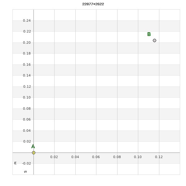
WDS 22077+2622 : COMPONENTS
22077+2622 A
| Componente originario normalizzato |
AB |
|
Coord arcsec 2000 |
220740.20+262135.8 |
|
Mag |
8.6 |
|
Spectral class |
G0 (yellow) |
|
| PmRA |
-17.00 |
|
PmDE |
-20.0 |
|
| Ccdm |
22077+2622 |
|
RComp |
|
|
Comp |
A |
|
Note1 |
|
|
| Note2 |
|
|
Discov num |
|
|
DRAs |
-1.80 |
|
DDEs |
-23.6 |
|
| R dRAs |
10 |
|
Year |
|
|
Theta |
|
|
Rho |
|
|
| Obs |
2 |
|
Vmag |
8.6 |
|
Sp |
G0 |
|
PmNote |
* |
|
| PmRA |
-6 |
|
PmDE |
-13 |
|
Dm number |
+25 4677 |
|
Cat1 |
BD |
|
| Name2 |
+26 2642 |
|
Cat2 |
AGK2/3 |
|
HD |
|
|
M HD |
|
|
| ADS BDS |
|
|
M ADS BDS |
|
|
N IDS |
|
|
IDS |
22031N2552A |
|
| HIC |
|
|
22077+2622 B
| Componente originario normalizzato |
AB |
|
Coord arcsec 2000 |
220740.19+262136.0 |
|
Mag |
8.8 |
|
Tycho2 |
2212-01321-1 |
|
| Calc delta mag |
0.2 |
|
Calc coord |
yes |
|
| Tycho2 |
2212-01321-1 |
|
Pflag |
|
|
RAmdeg |
331.91754705 |
|
DEmdeg |
26.35997633 |
|
| PmRA |
-16.1 |
|
PmDE |
-19.2 |
|
E RAmdeg |
12 |
|
E DEmdeg |
13 |
|
| E pmRA |
1.4 |
|
E pmDE |
1.3 |
|
EpRAm |
1990.41 |
|
EpDEm |
1989.35 |
|
| Num |
8 |
|
Q RAmdeg |
1.2 |
|
Q DEmdeg |
0.8 |
|
Q pmRA |
1.3 |
|
| Q pmDE |
0.8 |
|
BTmag |
9.683 |
|
E BTmag |
0.026 |
|
VTmag |
9.022 |
|
| E VTmag |
0.020 |
|
Prox |
897 |
|
TYC |
T |
|
HIP |
|
|
| CCDM |
|
|
RAdeg |
331.91758917 |
|
DEdeg |
26.36002139 |
|
EpRA 1990 |
1.76 |
|
| EpDE 1990 |
1.73 |
|
E RAdeg |
11.9 |
|
E DEdeg |
14.0 |
|
Posflg |
|
|
| Corr |
-0.1 |
|
| Ccdm |
22077+2622 |
|
RComp |
|
|
Comp |
B |
|
Note1 |
|
|
| Note2 |
|
|
Discov num |
COU 537 |
|
DRAs |
|
|
DDEs |
|
|
| R dRAs |
|
|
Year |
1970 |
|
Theta |
339 |
|
Rho |
0.3 |
|
| Obs |
1 |
|
Vmag |
8.8 |
|
Sp |
|
|
PmNote |
|
|
| PmRA |
|
|
PmDE |
|
|
Dm number |
|
|
Cat1 |
|
|
| Name2 |
|
|
Cat2 |
|
|
HD |
|
|
M HD |
|
|
| ADS BDS |
|
|
M ADS BDS |
|
|
N IDS |
|
|
IDS |
22031N2552B |
|
| HIC |
|
|