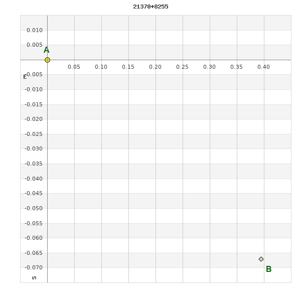
21370+8255 STF 2837 (HD 207146)
21h 36m 58.67s +82° 55' 16.5" P.A. 269.00 sep 3.2 mag 8.84,9.36 Sp G5
| Coord 2000 |
21370+8255 |
|
Discov num |
STF2837 |
|
Comp |
|
|
Coord arcsec 2000 |
21 36 58.67 +82 55 16.5 |
|
| Date first |
1832 |
|
Date last |
2018 |
|
Obs |
88 |
|
| Pa first |
321 |
|
Pa last |
268.8 |
|
P.A. Now (θ) |
268.8° |
|
| Sep first |
2.2 |
|
Sep last |
3.202 |
|
Sep. Now (ρ) |
3.202" |
|
| Mag pri |
8.84 |
|
Mag sec |
9.36 |
|
delta mag (ΔM) |
0.52 |
|
Spectral class |
G5 (yellow) |
|
| Pri motion ra |
+007 |
|
Sec motion ra |
|
|
| Pri motion dec |
-051 |
|
Sec motion dec |
|
|
| Notes |
O
(Orbital solution) |
|
This double is physical.
OTHER CATALOGS AND DESIGNATIONS
| Name |
HD 207146 |
|
Constellation |
Cepheus |
|
SAO |
3606 |
|
Tycho2 |
4649-00057-1 |
|
| Gaia DR2 |
2300220420283692672 |
|
HD |
207146 |
|
GC |
30375 |
|
ADS |
15229 |
|
ORBITAL ELEMENTS
| Period (P) | 1153.3017y | ± 590.6734 |
Periastron (T) | 1794.7941y | ± 82.5643 |
Semi-major axis (a) | 4.69589a | ± 1.90688 |
| Eccentricity (e) | 0.846 | ± 0.20093 |
Inclination (i) | 116.269° | ± 15.188 |
Longitude of periastron (ω) | 95.766° | ± 15.376 |
| Node (Ω) | 146.809° | ± 64.776 |
Notes | | |
Reference | Izm2019 | |
| Equinox | | |
Last observation | 2015 | |
Grade | 5 | (1=Definitive, 9=Indet.) |
| label |
theta |
rho |
| 2000 |
271.8 |
3.115 |
| 2001 |
271.7 |
3.118 |
| 2002 |
271.5 |
3.122 |
| 2003 |
271.3 |
3.125 |
| 2004 |
271.2 |
3.129 |
| 2005 |
271.0 |
3.132 |
| 2006 |
270.8 |
3.136 |
| 2007 |
270.7 |
3.139 |
| 2008 |
270.5 |
3.142 |
| 2009 |
270.3 |
3.146 |
| 2010 |
270.2 |
3.149 |
| 2011 |
270.0 |
3.152 |
| 2012 |
269.8 |
3.156 |
| 2013 |
269.7 |
3.159 |
| 2014 |
269.5 |
3.162 |
| 2015 |
269.4 |
3.166 |
| 2016 |
269.2 |
3.169 |
| 2017 |
269.0 |
3.172 |
| 2018 |
268.9 |
3.175 |
| 2019 |
268.7 |
3.179 |
| 2020 |
268.5 |
3.182 |
| 2021 |
268.4 |
3.185 |
| 2022 |
268.2 |
3.188 |
| 2023 |
268.1 |
3.191 |
| 2024 |
267.9 |
3.195 |
| 2025 |
267.8 |
3.198 |
| 2026 |
267.6 |
3.201 |
| 2027 |
267.4 |
3.204 |
| 2028 |
267.3 |
3.207 |
| 2029 |
267.1 |
3.210 |
| 2030 |
267.0 |
3.213 |
|
|
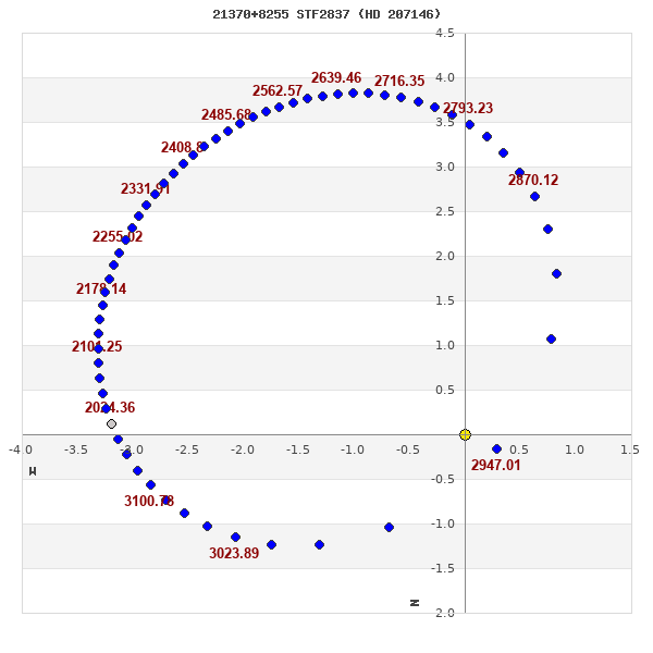
Note: Theta is PA, Rho is Sep. For yearly orbits, data refer to Jan 1st.
|
|
|
|
|
|
|
|
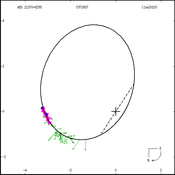
Measures: green=micrometric, blue=interferometric, purple=photographic |
|
WDS 21370+8255 STF 2837 (HD 207146) : NOTES
No records found.
REFERENCES
| refcode |
metd |
author |
reference |
| Izm2019 |
orb u |
Izmailov, I.S. |
2019AstL...45...30I |
| Izm2019 |
|
Ast. Lett. 45, 30, 2019 |
|
| Izm2019 |
|
(Orbital elements from weighted solutions used when available (Table 2), |
|
| Izm2019 |
|
unweighted elements (Table 1) used for remaining 29 systems.) |
|
DISCOVERER
| idgroup |
discov |
author |
| 1 |
STF |
Struve, F.G.W. |
WDS HISTORIC DATA
| coord_2000 |
discov_num |
comp |
epoch |
obs |
pa |
sep |
mag_pri |
mag_sec |
spectr |
notes |
coord_arcsec_2000 |
| 21370+8255 |
STF2837 |
|
2007 |
72 |
271 |
3.1 |
8.84 |
9.36 |
G5 |
L |
213658.67+825516.5 |
| 21370+8255 |
STF2837 |
|
2010 |
74 |
270 |
3.1 |
8.84 |
9.36 |
G5 |
L |
213658.67+825516.5 |
| 21370+8255 |
STF2837 |
|
2016 |
84 |
269 |
3.2 |
8.84 |
9.36 |
G5 |
O |
213658.67+825516.5 |
| 21370+8255 |
STF2837 |
|
2018 |
87 |
270 |
3.2 |
8.84 |
9.36 |
G5 |
O |
213658.67+825516.5 |
If you need more information about this double, apply for a
data request form to the WDS.
WDS 21370+8255 STF 2837 (HD 207146) : VISUAL OBSERVATIONS REPORTS
No records found.
WDS 21370+8255 STF 2837 (HD 207146) : MEASURES
No records found.
WDS 21370+8255 (HD 207146) : VIRTUAL EYEPIECE
Click on the map to see the double of your interest.
Pass over with the mouse cursor to display the catalog designation.
|
|
WDS 21370+8255 (HD 207146) : ALADIN DSS IMAGE @ 21h 36m 58.67s +82° 55' 16.5"
WDS 21370+8255 STF 2837 (HD 207146) : NEIGHBORHOODS
|
|
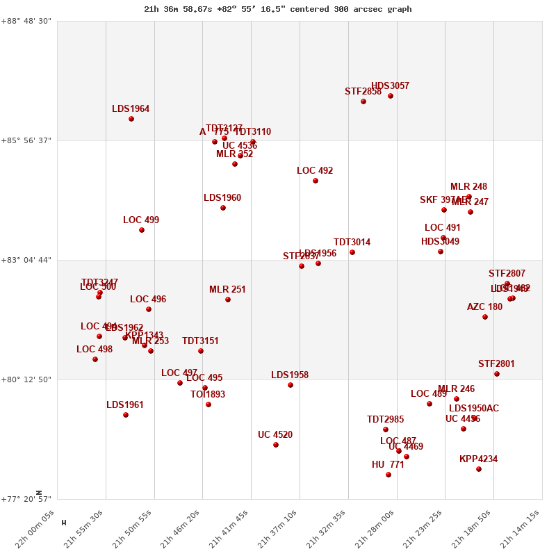
Click on the map to see the double of your interest.
Pass over with the mouse cursor to display the catalog designation.
|
| Show |
name |
coord_2000 |
discov# |
comp |
pa |
sep |
dist(') |
| Show |
|
21370+8255 |
STF2837 |
|
269 |
3.2 |
1 |
| Show |
|
21354+8300 |
LDS1956 |
|
351 |
62.2 |
6 |
| Show |
|
21322+8316 |
TDT3014 |
|
217 |
1.6 |
23 |
| Show |
|
21239+8317 |
HDS3049 |
|
339 |
0.3 |
33 |
| Show |
|
21176+8231 |
STF2807 |
|
310 |
1.8 |
45 |
| Show |
|
21236+8337 |
LOC 491 |
|
64 |
1.1 |
48 |
| Show |
|
21440+8208 |
MLR 251 |
|
43 |
1.6 |
50 |
| Show |
|
21561+8218 |
TDT3247 |
|
352 |
0.6 |
53 |
| Show |
|
21562+8212 |
LOC 500 |
|
200 |
5.2 |
58 |
| Show |
|
21521+8348 |
LOC 499 |
|
269 |
10.8 |
59 |
| Show |
|
21170+8210 |
LOC 482 |
|
75 |
1.7 |
60 |
| Show |
|
21164+8210 |
LDS1949 |
|
106 |
15.4 |
60 |
| Show |
|
21514+8154 |
LOC 496 |
|
251 |
5.3 |
68 |
| Show |
|
21196+8143 |
AZC 180 |
|
6 |
52.1 |
81 |
| Show |
|
21210+8413 |
MLR 247 |
|
301 |
2.1 |
83 |
| Show |
|
21235+8417 |
SKF 397 |
AB |
200 |
3.7 |
85 |
| Show |
|
21446+8420 |
LDS1960 |
|
358 |
84.4 |
86 |
| Show |
|
21211+8436 |
MLR 248 |
|
107 |
0.5 |
104 |
| Show |
|
21561+8115 |
LOC 494 |
|
359 |
26.1 |
108 |
| Show |
|
21540+8112 |
LDS1962 |
|
167 |
26.2 |
109 |
| Show |
|
21518+8102 |
KPP1343 |
|
232 |
10.1 |
118 |
| Show |
|
21357+8459 |
LOC 492 |
|
314 |
1.9 |
124 |
| Show |
|
21465+8053 |
TDT3151 |
|
301 |
1.0 |
124 |
| Show |
|
21513+8053 |
MLR 253 |
|
129 |
1.6 |
126 |
| Show |
|
21565+8042 |
LOC 498 |
|
104 |
1.4 |
140 |
| Show |
|
21433+8523 |
MLR 252 |
|
66 |
2.6 |
149 |
| Show |
|
21185+8021 |
STF2801 |
|
271 |
2.1 |
160 |
| Show |
|
21428+8535 |
UC 4536 |
|
33 |
27.2 |
160 |
| Show |
|
21485+8008 |
LOC 497 |
|
314 |
3.3 |
169 |
| Show |
|
21390+8002 |
LDS1958 |
|
206 |
8.5 |
171 |
| Show |
|
21461+8001 |
LOC 495 |
|
81 |
30.0 |
176 |
| Show |
|
21452+8554 |
A 775 |
|
205 |
2.8 |
180 |
| Show |
|
21415+8555 |
TDT3110 |
|
67 |
2.6 |
180 |
| Show |
|
21443+8559 |
TDT3127 |
|
117 |
0.5 |
185 |
| Show |
|
21223+7945 |
MLR 246 |
|
47 |
3.1 |
193 |
| Show |
|
21249+7938 |
LOC 489 |
|
31 |
1.5 |
200 |
| Show |
|
21458+7937 |
TOI1893 |
|
203 |
6.1 |
200 |
| Show |
|
21529+8627 |
LDS1964 |
|
63 |
121.7 |
214 |
| Show |
|
21536+7922 |
LDS1961 |
|
29 |
208.9 |
217 |
| Show |
|
21207+7916 |
LDS1950 |
AC |
287 |
5.3 |
222 |
| Show |
|
21290+7901 |
TDT2985 |
|
212 |
0.5 |
236 |
| Show |
|
21217+7902 |
UC 4456 |
|
353 |
30.2 |
237 |
| Show |
|
21312+8652 |
STF2858 |
|
157 |
14.4 |
238 |
| Show |
|
21285+8700 |
HDS3057 |
|
278 |
0.4 |
246 |
| Show |
|
21394+7839 |
UC 4520 |
|
189 |
30.6 |
257 |
| Show |
|
21278+7830 |
LOC 487 |
|
256 |
2.1 |
267 |
| Show |
|
21271+7822 |
UC 4469 |
|
188 |
9.1 |
274 |
| Show |
|
21202+7804 |
KPP4234 |
|
212 |
3.6 |
295 |
| Show |
|
21288+7756 |
HU 771 |
|
193 |
2.6 |
300 |
|
|
WDS 21370+8255 : COMPONENTS
21370+8255 A
| Componente originario normalizzato |
AB |
|
Name |
HD 207146 |
|
Coord arcsec 2000 |
213658.67+825516.5 |
|
Mag |
8.84 |
|
| Spectral class |
G5 (yellow) |
|
PmRA |
7.00 |
|
PmDE |
-51.0 |
|
SAO |
3606 |
|
| Tycho2 |
4649-00057-1 |
|
HD |
207146 |
|
GC |
30375 |
|
DM |
BD+82 657 |
|
| Tycho2 |
4649-00057-1 |
|
Pflag |
|
|
RAmdeg |
324.24446894 |
|
DEmdeg |
82.92125841 |
|
| PmRA |
9.0 |
|
PmDE |
-51.6 |
|
E RAmdeg |
9 |
|
E DEmdeg |
10 |
|
| E pmRA |
1.2 |
|
E pmDE |
1.2 |
|
EpRAm |
1991.10 |
|
EpDEm |
1990.84 |
|
| Num |
8 |
|
Q RAmdeg |
1.4 |
|
Q DEmdeg |
1.1 |
|
Q pmRA |
1.5 |
|
| Q pmDE |
1.1 |
|
BTmag |
9.677 |
|
E BTmag |
0.022 |
|
VTmag |
8.841 |
|
| E VTmag |
0.015 |
|
Prox |
31 |
|
TYC |
T |
|
HIP |
|
|
| CCDM |
|
|
RAdeg |
324.24430167 |
|
DEdeg |
82.92137750 |
|
EpRA 1990 |
1.77 |
|
| EpDE 1990 |
1.70 |
|
E RAdeg |
8.8 |
|
E DEdeg |
9.8 |
|
Posflg |
D |
|
| Corr |
0.0 |
|
| SAO |
3606 |
|
DelFlag |
|
|
RA1950 |
|
|
PmRA1950 |
-0.0041 |
|
| DE1950 |
|
|
PmDE1950 |
-0.042 |
|
Vmag |
8.7 |
|
SpType |
G5 |
|
| Double code |
|
|
Source |
70 |
|
CatNum |
30375 |
|
DM |
BD+82 657 |
|
| DMcomp |
|
|
BDsup |
|
|
HD |
207146 |
|
M HD |
0 |
|
| GC |
30375 |
|
RA1950rad |
5.67022276 |
|
DE1950rad |
1.4433054 |
|
PmRA2000 |
-0.0036 |
|
| PmDE2000 |
-0.047 |
|
| Ccdm |
21370+8255 |
|
RComp |
|
|
Comp |
A |
|
Note1 |
|
|
| Note2 |
|
|
Discov num |
|
|
DRAs |
-2.63 |
|
DDEs |
17.0 |
|
| R dRAs |
10 |
|
Year |
|
|
Theta |
|
|
Rho |
|
|
| Obs |
2 |
|
Vmag |
9.2 |
|
Sp |
G5 |
|
PmNote |
* |
|
| PmRA |
-24 |
|
PmDE |
-39 |
|
Dm number |
+82 657 |
|
Cat1 |
BD |
|
| Name2 |
+82 635 |
|
Cat2 |
AGK2/3 |
|
HD |
207146 |
|
M HD |
|
|
| ADS BDS |
A15229 |
|
M ADS BDS |
|
|
N IDS |
|
|
IDS |
21418N8228A |
|
| HIC |
|
|
21370+8255 B
| Componente originario normalizzato |
AB |
|
Coord arcsec 2000 |
213658.46+825516.4 |
|
Mag |
9.36 |
|
Calc delta mag |
0.52 |
|
| Calc coord |
yes |
|
| Ccdm |
21370+8255 |
|
RComp |
|
|
Comp |
B |
|
Note1 |
|
|
| Note2 |
|
|
Discov num |
STF2837 |
|
DRAs |
|
|
DDEs |
|
|
| R dRAs |
|
|
Year |
1953 |
|
Theta |
282 |
|
Rho |
2.9 |
|
| Obs |
23 |
|
Vmag |
9.7 |
|
Sp |
|
|
PmNote |
|
|
| PmRA |
|
|
PmDE |
|
|
Dm number |
|
|
Cat1 |
|
|
| Name2 |
|
|
Cat2 |
|
|
HD |
|
|
M HD |
|
|
| ADS BDS |
A15229 |
|
M ADS BDS |
|
|
N IDS |
|
|
IDS |
21418N8228B |
|
| HIC |
|
|