19414+3023 SLE 669 AB (HD 332361)
19h 41m 21.85s +30° 22' 55.0" P.A. 292.00 sep 10.8 mag 10.70,10.50 Sp A2
| Coord 2000 |
19414+3023 |
|
Discov num |
SLE 669 |
|
Comp |
AB |
|
Coord arcsec 2000 |
19 41 21.85 +30 22 55.0 |
|
| Date first |
1900 |
|
Date last |
2015 |
|
Obs |
12 |
|
| Pa first |
292 |
|
Pa last |
291.6 |
|
P.A. Now (θ) |
291.6° |
|
| Sep first |
10.9 |
|
Sep last |
10.805 |
|
Sep. Now (ρ) |
10.805" |
|
| Mag pri |
10.70 |
|
Mag sec |
10.50 |
|
delta mag (ΔM) |
0.2 |
|
Spectral class |
A2 (white) |
|
| Pri motion ra |
+002 |
|
Sec motion ra |
+000 |
|
| Pri motion dec |
-001 |
|
Sec motion dec |
-001 |
|
| Notes |
|
|
rPM=0.894
This double is not physical.
19414+3023 SYSTEM COMPONENTS
| Show |
name |
SAO |
coord |
wds_name |
last |
obs |
pa |
sep |
mag1 |
mag2 |
d_mag |
orb |
current |
| Show |
|
|
19 41 22 +30 22 55 |
TDT 1636 Aa,Ab |
1991 |
1 |
183 |
0.5 |
11.33 |
11.44 |
0.11 |
|
|
| Show |
HD 332361 |
|
19 41 22 +30 22 55 |
SLE 669 AB |
2015 |
12 |
292 |
10.8 |
10.70 |
10.50 |
0.20 |
|
<=== |
Triple system
2 estimated visually detectable stars in this system
OTHER CATALOGS AND DESIGNATIONS
| Name |
HD 332361 |
|
Constellation |
Cygnus |
|
Tycho2 |
2656-01190-1 |
|
Gaia DR2 |
2032838846187484160 |
|
| HD |
332361 |
|
WDS 19414+3023 SLE 669 AB (HD 332361) : NOTES
No records found.
REFERENCES
| refcode |
metd |
author |
reference |
| Sle1966 |
Mc j |
Soulie, G. |
1966JO.....49..359S |
| Sle1966 |
+Pa |
J. Obs. 49, 359, 1966 |
|
| Sle1983 |
Pa - |
Soulie, G. |
1983A&AS...54..281S |
| Sle1983 |
|
A&AS 54, 281, 1983 |
|
| Sle1984 |
Pa - |
Soulie, G. |
1984A&AS...56..351S |
| Sle1984 |
|
A&AS 56, 351, 1984 |
|
| Sle1985 |
Pa - |
Soulie, G. |
1985A&AS...61...17S |
| Sle1985 |
|
A&AS 61, 17, 1985 |
|
| Sle1986a |
Pa - |
Soulie, G. |
. |
| Sle1986a |
|
Bull. Inf. Cent. Donnes Stell. #30, 91, 1986 |
|
| Sle1986b |
Pa - |
Soulie, G. |
. |
| Sle1986b |
|
Bull. Inf. Cent. Donnes Stell. #30, 103, 1986 |
|
| Sle2003 |
C j |
Soulie, G. |
2003O&T....56...10S |
| Sle2003 |
|
Obs. et Travaux 56, 10, 2003 |
|
| Sle2006 |
Pa - |
Soulie, G. |
2006O&T....62...26S |
| Sle2006 |
|
Obs. et Travaux 62, 26, 2006 |
|
| Sle2006b |
Pa j |
Soulie, G. |
2006O&T....63...15S |
| Sle2006b |
|
Obs. et Travaux 63, 15, 2006 |
|
| Sle2007 |
C j |
Soulie, G. |
2007O&T....65...34S |
| Sle2007 |
|
Obs. et Travaux 65, 34, 2007 |
|
WDS HISTORIC DATA
| coord_2000 |
discov_num |
comp |
epoch |
obs |
pa |
sep |
mag_pri |
mag_sec |
spectr |
notes |
coord_arcsec_2000 |
| 19414+3023 |
SLE 669 |
AB |
1998 |
4 |
292 |
10.8 |
10.70 |
10.50 |
|
D |
194121.85+302255.0 |
| 19414+3023 |
SLE 669 |
AB |
2007 |
5 |
292 |
10.7 |
10.70 |
10.50 |
|
D |
194121.85+302255.0 |
| 19414+3023 |
SLE 669 |
AB |
2010 |
6 |
292 |
10.9 |
10.70 |
10.50 |
|
D |
194121.85+302255.0 |
| 19414+3023 |
SLE 669 |
AB |
2015 |
8 |
292 |
11.0 |
10.70 |
10.50 |
A2 |
|
194121.85+302255.0 |
If you need more information about this double, apply for a
data request form to the WDS.
WDS 19414+3023 SLE 669 AB (HD 332361) : VISUAL OBSERVATIONS REPORTS
No records found.
WDS 19414+3023 SLE 669 AB (HD 332361) : MEASURES
No records found.
WDS 19414+3023 (HD 332361) : VIRTUAL EYEPIECE
Click on the map to see the double of your interest.
Pass over with the mouse cursor to display the catalog designation.
|
|
WDS 19414+3023 (HD 332361) : ALADIN DSS IMAGE @ 19h 41m 21.85s +30° 22' 55.0"
WDS 19414+3023 SLE 669 AB (HD 332361) : NEIGHBORHOODS
|
|

Click on the map to see the double of your interest.
Pass over with the mouse cursor to display the catalog designation.
|
| Show |
name |
coord_2000 |
discov# |
comp |
pa |
sep |
dist(') |
| Show |
|
19414+3023 |
TDT1636 |
Aa,Ab |
183 |
0.5 |
1 |
| Show |
|
19414+3023 |
SLE 669 |
AB |
292 |
10.8 |
1 |
| Show |
|
19404+3026 |
SLE 664 |
|
180 |
6.9 |
13 |
| Show |
|
19413+3043 |
BU 145 |
AB |
271 |
0.9 |
21 |
| Show |
|
19413+3043 |
BU 145 |
AC |
28 |
7.9 |
21 |
| Show |
|
19413+3043 |
BU 145 |
AD |
156 |
26.7 |
21 |
| Show |
|
19401+3037 |
J 776 |
AB |
47 |
3.5 |
21 |
| Show |
|
19401+3037 |
J 776 |
AC |
33 |
27.7 |
21 |
| Show |
|
19414+2959 |
BRT 41 |
|
156 |
3.7 |
25 |
| Show |
|
19394+3029 |
SLE 659 |
AB |
107 |
8.4 |
27 |
| Show |
|
19394+3029 |
SLE 659 |
AC |
88 |
15.5 |
27 |
| Show |
|
19394+3029 |
BKO 76 |
AD |
250 |
80.3 |
27 |
| Show |
|
19394+3029 |
FYM 175 |
AF |
182 |
23.6 |
27 |
| Show |
|
19394+3029 |
FYM 175 |
FG |
22 |
7.3 |
28 |
| Show |
|
19394+3029 |
BKO 76 |
DE |
258 |
3.4 |
28 |
| Show |
|
19394+3009 |
MCA 57 |
|
247 |
0.0 |
30 |
| Show |
|
19399+3001 |
SLE 661 |
|
158 |
10.9 |
30 |
| Show |
|
19399+3037 |
BRT3347 |
AB |
211 |
1.7 |
33 |
| Show |
|
19399+3037 |
BRT3347 |
AC |
74 |
2.2 |
33 |
| Show |
|
19418+3056 |
TDT1645 |
|
207 |
1.1 |
34 |
| Show |
|
19386+3026 |
SLE 653 |
|
338 |
11.5 |
37 |
| Show |
|
19442+3015 |
HJ 1434 |
|
300 |
8.3 |
38 |
| Show |
|
19443+3021 |
BEW 3 |
|
302 |
11.5 |
39 |
| Show |
|
19413+2944 |
SLE 668 |
|
268 |
10.9 |
39 |
| Show |
|
19417+3103 |
A 371 |
|
19 |
1.9 |
41 |
| Show |
|
19425+3102 |
BRT 266 |
|
161 |
6.4 |
42 |
| Show |
|
19396+2945 |
STF2557 |
AB |
103 |
11.0 |
45 |
| Show |
|
19396+2945 |
BU 54 |
AC |
304 |
21.8 |
45 |
| Show |
|
19396+2945 |
ABH 124 |
AD |
147 |
47.8 |
45 |
| Show |
|
19396+2945 |
ABH 124 |
AE |
164 |
65.7 |
45 |
| Show |
|
19396+2945 |
ABH 124 |
AF |
180 |
89.2 |
45 |
| Show |
|
19396+2945 |
ABH 124 |
AG |
229 |
39.4 |
45 |
| Show |
|
19396+2945 |
ABH 124 |
AH |
92 |
103.6 |
45 |
| Show |
|
19396+2945 |
ABH 124 |
AI |
116 |
100.5 |
45 |
| Show |
|
19396+2945 |
BKO 77 |
AJ |
124 |
27.9 |
45 |
| Show |
|
19396+2945 |
BKO 77 |
AK |
97 |
69.2 |
45 |
| Show |
|
19396+2945 |
BKO 77 |
AL |
220 |
30.0 |
45 |
| Show |
|
19396+2945 |
BKO 77 |
AM |
120 |
111.9 |
45 |
| Show |
|
19415+2937 |
SLE 670 |
|
164 |
10.0 |
47 |
| Show |
|
19377+3022 |
BU 144 |
|
356 |
6.1 |
47 |
| Show |
|
19386+2953 |
COU1162 |
Aa,Ab |
127 |
0.7 |
47 |
| Show |
|
19386+2953 |
SLE 654 |
AB |
92 |
15.5 |
47 |
| Show |
|
19394+2942 |
SLE 658 |
AB |
14 |
6.0 |
48 |
| Show |
|
19394+2942 |
FYM 134 |
AC |
149 |
4.7 |
48 |
| Show |
|
19376+3030 |
LDS1026 |
|
138 |
17.9 |
51 |
| Show |
|
19374+3026 |
COU1319 |
|
138 |
2.6 |
51 |
| Show |
|
19374+3025 |
A 370 |
|
264 |
4.9 |
52 |
| Show |
|
19376+3006 |
BRT 39 |
AB |
166 |
5.1 |
52 |
| Show |
|
19431+2935 |
TDT1670 |
|
308 |
1.5 |
53 |
| Show |
|
19421+2934 |
OL 121 |
|
221 |
0.9 |
54 |
| Show |
|
19439+3105 |
BRT 268 |
BC |
132 |
4.6 |
54 |
|
|
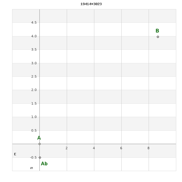
WDS 19414+3023 : COMPONENTS
| |
A |
Ab |
| Ab |
pa=182.2°
sep=0.50"
| |
| B |
pa=294.7°
sep=9.54"
| pa=297.4°
sep=9.74"
|
19414+3023 A
| Name |
HD 332361 |
|
Coord arcsec 2000 |
194121.85+302255.0 |
|
Mag |
10.7 |
|
Spectral class |
A2 (white) |
|
| PmRA |
2.00 |
|
PmDE |
-1.0 |
|
Tycho2 |
2656-01190-1 |
|
HD |
332361 |
|
| Tycho2 |
2656-01190-1 |
|
Pflag |
|
|
RAmdeg |
295.34109205 |
|
DEmdeg |
30.38196474 |
|
| PmRA |
5.8 |
|
PmDE |
-2.2 |
|
E RAmdeg |
34 |
|
E DEmdeg |
30 |
|
| E pmRA |
2.3 |
|
E pmDE |
2.2 |
|
EpRAm |
1988.91 |
|
EpDEm |
1989.67 |
|
| Num |
3 |
|
Q RAmdeg |
1.0 |
|
Q DEmdeg |
3.1 |
|
Q pmRA |
1.0 |
|
| Q pmDE |
3.1 |
|
BTmag |
11.043 |
|
E BTmag |
0.048 |
|
VTmag |
10.705 |
|
| E VTmag |
0.054 |
|
Prox |
901 |
|
TYC |
T |
|
HIP |
|
|
| CCDM |
|
|
RAdeg |
295.34107611 |
|
DEdeg |
30.38196972 |
|
EpRA 1990 |
1.57 |
|
| EpDE 1990 |
1.76 |
|
E RAdeg |
34.8 |
|
E DEdeg |
29.7 |
|
Posflg |
|
|
| Corr |
0.1 |
|
19414+3023 Ab
| Coord arcsec 2000 |
194121.85+302254.5 |
|
Mag |
11.44 |
|
PmRA |
6.00 |
|
PmDE |
-2.0 |
|
| Calc delta mag |
0.11 |
|
Calc coord |
yes |
|
19414+3023 B
| Coord arcsec 2000 |
194121.18+302259.0 |
|
Mag |
10.5 |
|
PmRA |
0.00 |
|
PmDE |
-1.0 |
|
| Calc delta mag |
0.83 |
|
Calc coord |
yes |
|