18150-5018 I 429 (HD 166839)
18h 15m 00.43s -50° 18' 29.0" P.A. 303.00 sep 0.1 mag 8.00,8.20 Sp A0V
| Coord 2000 |
18150-5018 |
|
Discov num |
I 429 |
|
Comp |
|
|
Coord arcsec 2000 |
18 15 00.43 -50 18 29.0 |
|
| Date first |
1902 |
|
Date last |
2021 |
|
Obs |
29 |
|
| Pa first |
150 |
|
Pa last |
302.5 |
|
P.A. Now (θ) |
124.8° |
|
| Sep first |
0.5 |
|
Sep last |
0.056 |
|
Sep. Now (ρ) |
0.076" |
|
| Mag pri |
8.00 |
|
Mag sec |
8.20 |
|
delta mag (ΔM) |
0.2 |
|
Spectral class |
A0V (white) |
|
| Pri motion ra |
+004 |
|
Sec motion ra |
|
|
| Pri motion dec |
-038 |
|
Sec motion dec |
|
|
| Notes |
N
O
(See Notes, Orbital solution) |
|
This double is physical.
OTHER CATALOGS AND DESIGNATIONS
| Name |
HD 166839 |
|
Constellation |
Telescopium |
|
SAO |
245344 |
|
Tycho2 |
8366-02361-1 |
|
| Gaia DR2 |
6703329357805862016 |
|
HD |
166839 |
|
GC |
24867 |
|
ORBITAL ELEMENTS SOLUTION #1
| Period (P) | 69.81y | ± 2 |
Periastron (T) | 1946.53y | ± 0.85 |
Semi-major axis (a) | 0.096a | ± 0.003 |
| Eccentricity (e) | 0.887 | ± 0.01 |
Inclination (i) | 66.1° | ± 3 |
Longitude of periastron (ω) | 355.9° | ± 10 |
| Node (Ω) | 320.1° | ± 6 |
Notes | n | |
Reference | Doc2022b | |
| Equinox | | |
Last observation | 2021 | |
Grade | 3 | (1=Definitive, 9=Indet.) |
| label |
theta |
rho |
| 2000 |
144.3 |
0.144 |
| 2001 |
144.7 |
0.139 |
| 2002 |
145.2 |
0.134 |
| 2003 |
145.7 |
0.129 |
| 2004 |
146.3 |
0.123 |
| 2005 |
146.9 |
0.117 |
| 2006 |
147.6 |
0.110 |
| 2007 |
148.4 |
0.103 |
| 2008 |
149.3 |
0.096 |
| 2009 |
150.3 |
0.087 |
| 2010 |
151.6 |
0.078 |
| 2011 |
153.3 |
0.068 |
| 2012 |
155.5 |
0.058 |
| 2013 |
158.9 |
0.045 |
| 2014 |
165.0 |
0.032 |
| 2015 |
182.0 |
0.016 |
| 2016 |
286.6 |
0.008 |
| 2017 |
24.1 |
0.008 |
| 2018 |
96.4 |
0.019 |
| 2019 |
111.1 |
0.032 |
| 2020 |
117.2 |
0.045 |
| 2021 |
120.7 |
0.056 |
| 2022 |
123.1 |
0.067 |
| 2023 |
124.8 |
0.076 |
| 2024 |
126.2 |
0.085 |
| 2025 |
127.3 |
0.093 |
| 2026 |
128.3 |
0.100 |
| 2027 |
129.1 |
0.107 |
| 2028 |
129.8 |
0.114 |
| 2029 |
130.5 |
0.120 |
| 2030 |
131.1 |
0.126 |
|
|
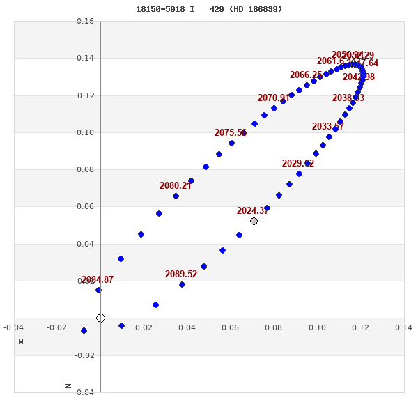
Note: Theta is PA, Rho is Sep. For yearly orbits, data refer to Jan 1st.
|
|
|
|
|
|
|
|
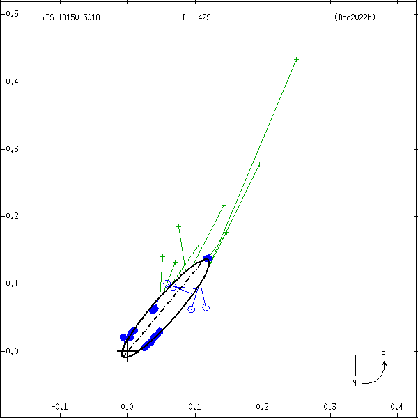
Measures: green=micrometric, blue=interferometric, purple=photographic |
|
ORBITAL ELEMENTS SOLUTION #2
| Period (P) | 130y | |
Periastron (T) | 2013.19y | ± 4.23 |
Semi-major axis (a) | 0.193a | ± 0.004 |
| Eccentricity (e) | 0.129 | ± 0.031 |
Inclination (i) | 84.8° | ± 0.4 |
Longitude of periastron (ω) | 78.8° | ± 14.7 |
| Node (Ω) | 138.1° | ± 0.7 |
Notes | n | |
Reference | Tok2021f | |
| Equinox | | |
Last observation | 2021 | |
Grade | 3 | (1=Definitive, 9=Indet.) |
| label |
theta |
rho |
| 2000 |
141.4 |
0.148 |
| 2001 |
141.8 |
0.141 |
| 2002 |
142.3 |
0.135 |
| 2003 |
142.8 |
0.127 |
| 2004 |
143.5 |
0.120 |
| 2005 |
144.1 |
0.112 |
| 2006 |
145.0 |
0.103 |
| 2007 |
145.9 |
0.094 |
| 2008 |
147.1 |
0.085 |
| 2009 |
148.5 |
0.076 |
| 2010 |
150.3 |
0.067 |
| 2011 |
152.8 |
0.057 |
| 2012 |
156.2 |
0.047 |
| 2013 |
161.4 |
0.038 |
| 2014 |
170.1 |
0.028 |
| 2015 |
186.2 |
0.020 |
| 2016 |
216.8 |
0.016 |
| 2017 |
254.4 |
0.017 |
| 2018 |
278.0 |
0.024 |
| 2019 |
290.2 |
0.032 |
| 2020 |
297.1 |
0.042 |
| 2021 |
301.4 |
0.051 |
| 2022 |
304.4 |
0.061 |
| 2023 |
306.5 |
0.071 |
| 2024 |
308.1 |
0.080 |
| 2025 |
309.4 |
0.089 |
| 2026 |
310.5 |
0.098 |
| 2027 |
311.4 |
0.107 |
| 2028 |
312.1 |
0.115 |
| 2029 |
312.8 |
0.124 |
| 2030 |
313.3 |
0.131 |
|
|
Note: Theta is PA, Rho is Sep. For yearly orbits, data refer to Jan 1st.
|
|
|
|
|
|
|
|
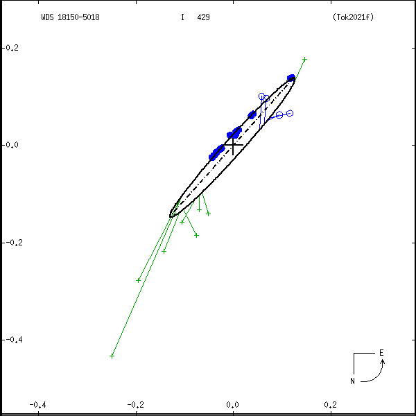
Measures: green=micrometric, blue=interferometric, purple=photographic |
|
WDS 18150-5018 I 429 (HD 166839) : NOTES
| discov_num |
notes |
refcode |
| I 429 |
Measures scattered, but probable rapid motion. |
|
REFERENCES
| refcode |
metd |
author |
reference |
| Doc2022b |
orb - |
Docobo, J.A., Campo, P., Mendez, R.A., & Costa, E. |
2022IAUDS.206....1S |
| Doc2022b |
|
Inf. Circ. 206, 1, 2021 |
|
| Tok2021f |
orb - |
Tokovinin, A. |
2021IAUDS.204....1T |
| Tok2021f |
|
Inf. Circ. 204, 1, 2021 |
|
DISCOVERER
| idgroup |
discov |
author |
| 1 |
I |
Innes, R.T.A. |
| 5 |
I |
MNRAS 57, 533, 1897 (data also in I__1897b, |
| 5 |
I |
I__1897c) |
WDS HISTORIC DATA
| coord_2000 |
discov_num |
comp |
epoch |
obs |
pa |
sep |
mag_pri |
mag_sec |
spectr |
notes |
coord_arcsec_2000 |
| 18150-5018 |
I 429 |
|
1991 |
16 |
140 |
0.2 |
8.00 |
8.20 |
A0V |
N |
181500.43-501829.0 |
| 18150-5018 |
I 429 |
|
2009 |
18 |
149 |
0.1 |
8.00 |
8.20 |
A0V |
N |
181500.43-501829.0 |
| 18150-5018 |
I 429 |
|
2013 |
19 |
162 |
0.0 |
8.00 |
8.20 |
A0V |
N |
181500.43-501829.0 |
| 18150-5018 |
I 429 |
|
2014 |
21 |
169 |
0.0 |
8.00 |
8.20 |
A0V |
N |
181500.43-501829.0 |
| 18150-5018 |
I 429 |
|
2015 |
22 |
198 |
0.0 |
8.00 |
8.20 |
A0V |
N |
181500.43-501829.0 |
| 18150-5018 |
I 429 |
|
2018 |
24 |
289 |
0.0 |
8.00 |
8.20 |
A0V |
NO |
181500.43-501829.0 |
| 18150-5018 |
I 429 |
|
2019 |
26 |
293 |
0.0 |
8.00 |
8.20 |
A0V |
NO |
181500.43-501829.0 |
| 18150-5018 |
I 429 |
|
2020 |
28 |
300 |
0.1 |
8.00 |
8.20 |
A0V |
NO |
181500.43-501829.0 |
| 18150-5018 |
I 429 |
|
2021 |
29 |
303 |
0.1 |
8.00 |
8.20 |
A0V |
NO |
181500.43-501829.0 |
If you need more information about this double, apply for a
data request form to the WDS.
WDS 18150-5018 I 429 (HD 166839) : VISUAL OBSERVATIONS REPORTS
No records found.
WDS 18150-5018 I 429 (HD 166839) : MEASURES
No records found.
WDS 18150-5018 (HD 166839) : VIRTUAL EYEPIECE
Click on the map to see the double of your interest.
Pass over with the mouse cursor to display the catalog designation.
|
|
WDS 18150-5018 (HD 166839) : ALADIN DSS IMAGE @ 18h 15m 00.43s -50° 18' 29.0"
WDS 18150-5018 I 429 (HD 166839) : NEIGHBORHOODS
|
|

Click on the map to see the double of your interest.
Pass over with the mouse cursor to display the catalog designation.
|
| Show |
name |
coord_2000 |
discov# |
comp |
pa |
sep |
dist(') |
| Show |
|
18150-5018 |
I 429 |
|
303 |
0.1 |
|
| Show |
|
18146-5031 |
BRT1037 |
|
323 |
4.5 |
14 |
| Show |
|
18129-5034 |
HDO 288 |
|
116 |
1.6 |
25 |
| Show |
|
18133-4955 |
B 2434 |
|
203 |
6.3 |
29 |
| Show |
|
18129-4959 |
HRG 128 |
|
358 |
6.8 |
30 |
| Show |
|
18130-5044 |
RST 971 |
|
112 |
0.3 |
32 |
| Show |
|
18104-5019 |
RST 968 |
|
137 |
0.6 |
44 |
| Show |
|
18153-4928 |
TOK 915 |
|
283 |
0.1 |
51 |
| Show |
|
18174-4929 |
HDS2586 |
|
32 |
2.3 |
55 |
| Show |
|
18189-5107 |
RST 974 |
|
206 |
0.3 |
61 |
| Show |
|
18165-4913 |
SKF1145 |
|
158 |
52.9 |
68 |
| Show |
|
18205-5107 |
BRT1043 |
|
85 |
5.5 |
71 |
| Show |
|
18177-4910 |
BRT1040 |
|
99 |
5.5 |
74 |
| Show |
|
18199-5121 |
LDS 637 |
|
162 |
23.0 |
74 |
| Show |
|
18071-4949 |
I 1350 |
|
210 |
0.6 |
82 |
| Show |
|
18232-4953 |
KPP1538 |
|
285 |
11.6 |
83 |
| Show |
|
18075-5106 |
RST 964 |
|
232 |
5.4 |
86 |
| Show |
|
18063-5045 |
TDT 685 |
|
293 |
0.5 |
87 |
| Show |
|
18154-4851 |
HJ 5033 |
AB |
113 |
17.3 |
88 |
| Show |
|
18154-4851 |
HJ 5033 |
AC |
10 |
15.6 |
88 |
| Show |
|
18154-4851 |
HJ 5033 |
AD |
69 |
25.4 |
88 |
| Show |
|
18204-4908 |
I 1361 |
|
254 |
2.3 |
88 |
| Show |
|
18155-5149 |
HDS2578 |
|
333 |
0.4 |
91 |
| Show |
|
18244-5042 |
TDT 842 |
|
298 |
1.1 |
93 |
| Show |
|
18119-5147 |
RST 970 |
|
201 |
1.3 |
94 |
| Show |
|
18065-4931 |
I 622 |
|
44 |
0.6 |
96 |
| Show |
|
18231-4923 |
UC 3568 |
|
271 |
36.6 |
96 |
| Show |
|
18242-4942 |
UC 3572 |
|
156 |
74.0 |
97 |
| Show |
|
18074-5124 |
RST 963 |
|
101 |
3.2 |
98 |
| Show |
|
18210-5139 |
UC 3556 |
|
69 |
62.8 |
99 |
| Show |
|
18240-5108 |
HDS2602 |
|
13 |
3.6 |
99 |
| Show |
|
18100-4852 |
HJ 5017 |
|
320 |
22.5 |
100 |
| Show |
|
18206-5144 |
CPO 582 |
|
156 |
4.2 |
100 |
| Show |
|
18252-5048 |
UC 3575 |
|
30 |
21.8 |
102 |
| Show |
|
18245-4932 |
UC 3574 |
|
277 |
34.8 |
104 |
| Show |
|
18080-5139 |
RST 967 |
|
7 |
2.6 |
105 |
| Show |
|
18124-4836 |
I 1354 |
|
163 |
1.3 |
107 |
| Show |
|
18221-4857 |
RST 979 |
|
222 |
0.4 |
107 |
| Show |
|
18150-4832 |
RSS 479 |
|
207 |
24.6 |
107 |
| Show |
|
18150-4831 |
I 1356 |
AB |
320 |
0.4 |
108 |
| Show |
|
18150-4831 |
I 1356 |
AC |
167 |
8.1 |
108 |
| Show |
|
18201-5156 |
RST 975 |
|
212 |
0.6 |
108 |
| Show |
|
18119-5205 |
DAW 21 |
BC |
102 |
1.6 |
111 |
| Show |
|
18119-5205 |
HJ 5022 |
A,BC |
97 |
6.1 |
111 |
| Show |
|
18267-4957 |
BRT1053 |
|
268 |
5.1 |
115 |
| Show |
|
18050-4917 |
B 2854 |
|
7 |
5.6 |
116 |
| Show |
|
18261-5107 |
UC 3581 |
|
331 |
37.8 |
116 |
| Show |
|
18220-4845 |
SWR 243 |
|
93 |
24.6 |
116 |
| Show |
|
18249-5128 |
KPP2547 |
|
223 |
23.0 |
117 |
| Show |
|
18207-5203 |
HDS2593 |
|
79 |
13.9 |
118 |
| Show |
|
18026-5013 |
HDS2540 |
|
14 |
16.8 |
119 |
|
|
WDS 18150-5018 : COMPONENTS
18150-5018 A
| Componente originario normalizzato |
AB |
|
Name |
HD 166839 |
|
Coord arcsec 2000 |
181500.43-501829.0 |
|
Mag |
8 |
|
| Spectral class |
A0V (white) |
|
PmRA |
4.00 |
|
PmDE |
-38.0 |
|
SAO |
245344 |
|
| Tycho2 |
8366-02361-1 |
|
HD |
166839 |
|
GC |
24867 |
|
DM |
CD-5011800 |
|
| Tycho2 |
8366-02361-1 |
|
Pflag |
|
|
RAmdeg |
273.75180290 |
|
DEmdeg |
-50.30806586 |
|
| PmRA |
3.0 |
|
PmDE |
-33.2 |
|
E RAmdeg |
4 |
|
E DEmdeg |
4 |
|
| E pmRA |
1.0 |
|
E pmDE |
1.0 |
|
EpRAm |
1991.30 |
|
EpDEm |
1991.32 |
|
| Num |
13 |
|
Q RAmdeg |
0.8 |
|
Q DEmdeg |
0.8 |
|
Q pmRA |
0.7 |
|
| Q pmDE |
0.8 |
|
BTmag |
7.263 |
|
E BTmag |
0.015 |
|
VTmag |
7.225 |
|
| E VTmag |
0.010 |
|
Prox |
999 |
|
TYC |
T |
|
HIP |
|
|
| CCDM |
|
|
RAdeg |
273.75179194 |
|
DEdeg |
-50.30798889 |
|
EpRA 1990 |
1.69 |
|
| EpDE 1990 |
1.66 |
|
E RAdeg |
3.9 |
|
E DEdeg |
4.4 |
|
Posflg |
|
|
| Corr |
0.0 |
|
| SAO |
245344 |
|
DelFlag |
|
|
RA1950 |
|
|
PmRA1950 |
-0.0035 |
|
| DE1950 |
|
|
PmDE1950 |
-0.024 |
|
Vmag |
7.3 |
|
SpType |
A0 |
|
| Double code |
|
|
Source |
70 |
|
CatNum |
24867 |
|
DM |
CD-5011800 |
|
| DMcomp |
|
|
BDsup |
|
|
HD |
166839 |
|
M HD |
0 |
|
| GC |
24867 |
|
RA1950rad |
4.76082533 |
|
DE1950rad |
-0.87830751 |
|
PmRA2000 |
-0.0037 |
|
| PmDE2000 |
-0.027 |
|
| Ccdm |
18150-5018 |
|
RComp |
|
|
Comp |
A |
|
Note1 |
|
|
| Note2 |
|
|
Discov num |
|
|
DRAs |
0.44 |
|
DDEs |
-29.1 |
|
| R dRAs |
10 |
|
Year |
|
|
Theta |
|
|
Rho |
|
|
| Obs |
2 |
|
Vmag |
8.0 |
|
Sp |
A0 |
|
PmNote |
* |
|
| PmRA |
2 |
|
PmDE |
-32 |
|
Dm number |
-5011800 |
|
Cat1 |
CD |
|
| Name2 |
245344 |
|
Cat2 |
SAO |
|
HD |
166839 |
|
M HD |
|
|
| ADS BDS |
|
|
M ADS BDS |
|
|
N IDS |
|
|
IDS |
18072S5020A |
|
| HIC |
|
|
18150-5018 B
| Componente originario normalizzato |
AB |
|
Coord arcsec 2000 |
181500.43-501829.0 |
|
Mag |
8.2 |
|
Calc delta mag |
0.2 |
|
| Calc coord |
yes |
|
| Ccdm |
18150-5018 |
|
RComp |
|
|
Comp |
B |
|
Note1 |
|
|
| Note2 |
|
|
Discov num |
I 429 |
|
DRAs |
|
|
DDEs |
|
|
| R dRAs |
|
|
Year |
1952 |
|
Theta |
|
|
Rho |
0.1 |
|
| Obs |
7 |
|
Vmag |
8.2 |
|
Sp |
|
|
PmNote |
|
|
| PmRA |
|
|
PmDE |
|
|
Dm number |
|
|
Cat1 |
|
|
| Name2 |
|
|
Cat2 |
|
|
HD |
|
|
M HD |
|
|
| ADS BDS |
|
|
M ADS BDS |
N |
|
N IDS |
|
|
IDS |
18072S5020B |
|
| HIC |
|
|