17502+4424 SIG 3
17h 50m 12.91s +44° 24' 04.3" P.A. 68.00 sep 0.2 mag 13.20,14.00 Sp M7.5+L0
| Coord 2000 |
17502+4424 |
|
Discov num |
SIG 3 |
|
Comp |
|
|
Coord arcsec 2000 |
17 50 12.91 +44 24 04.3 |
|
| Date first |
2002 |
|
Date last |
2010 |
|
Obs |
12 |
|
| Pa first |
340 |
|
Pa last |
67.6 |
|
P.A. Now (θ) |
67.6° |
|
| Sep first |
0.2 |
|
Sep last |
0.222 |
|
Sep. Now (ρ) |
0.222" |
|
| Mag pri |
13.20 |
|
Mag sec |
14.00 |
|
delta mag (ΔM) |
0.8 |
|
Spectral class |
M7.5+L0 (red/very deep red) |
|
| Pri motion ra |
-014 |
|
Sec motion ra |
|
|
| Pri motion dec |
+138 |
|
Sec motion dec |
|
|
| Notes |
N
O
K
(See Notes, Orbital solution, K-band or other infrared magnitudes) |
|
Visually invisible, K-band or other infrared star : Summary line gives K-band or other infrared (>1 micron) magnitudes
This double is physical.
OTHER CATALOGS AND DESIGNATIONS
| Constellation |
Hercules |
|
Gaia DR2 |
1349492949336359936 |
|
ORBITAL ELEMENTS SOLUTION #1
| Period (P) | 317y | ± 240 |
Periastron (T) | 2004.3y | ± 1.8 |
Semi-major axis (a) | 0.728a | ± 0.375 |
| Eccentricity (e) | 0.71 | ± 0.18 |
Inclination (i) | 44° | ± 10 |
Longitude of periastron (ω) | 267° | ± 26 |
| Node (Ω) | 99° | ± 6 |
Notes | n | |
Reference | Kon2010 | |
| Equinox | 2000 | |
Last observation | 2009 | |
Grade | 5 | (1=Definitive, 9=Indet.) |
| label |
theta |
rho |
| 2000 |
318.3 |
0.198 |
| 2001 |
326.7 |
0.182 |
| 2002 |
336.7 |
0.168 |
| 2003 |
348.2 |
0.158 |
| 2004 |
0.9 |
0.153 |
| 2005 |
14.1 |
0.153 |
| 2006 |
26.8 |
0.158 |
| 2007 |
38.3 |
0.168 |
| 2008 |
48.3 |
0.182 |
| 2009 |
56.8 |
0.198 |
| 2010 |
64.0 |
0.215 |
| 2011 |
70.1 |
0.233 |
| 2012 |
75.3 |
0.252 |
| 2013 |
79.8 |
0.270 |
| 2014 |
83.7 |
0.287 |
| 2015 |
87.2 |
0.305 |
| 2016 |
90.3 |
0.321 |
| 2017 |
93.1 |
0.338 |
| 2018 |
95.7 |
0.353 |
| 2019 |
98.0 |
0.368 |
| 2020 |
100.2 |
0.383 |
| 2021 |
102.2 |
0.397 |
| 2022 |
104.0 |
0.410 |
| 2023 |
105.8 |
0.423 |
| 2024 |
107.5 |
0.436 |
| 2025 |
109.0 |
0.448 |
| 2026 |
110.5 |
0.460 |
| 2027 |
111.9 |
0.471 |
| 2028 |
113.2 |
0.482 |
| 2029 |
114.5 |
0.492 |
| 2030 |
115.8 |
0.503 |
|
|

Note: Theta is PA, Rho is Sep. For yearly orbits, data refer to Jan 1st.
|
|
|
|
|
|
|
|
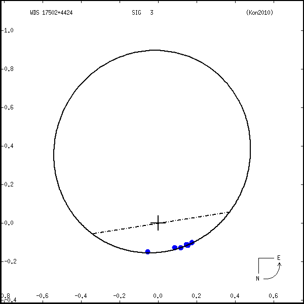
Measures: green=micrometric, blue=interferometric, purple=photographic |
|
ORBITAL ELEMENTS SOLUTION #2
| Period (P) | 170y | ± 60 |
Periastron (T) | 2170.9974y | |
Semi-major axis (a) | 580m | ± 150 |
| Eccentricity (e) | 0.7 | ± 0.09 |
Inclination (i) | 53° | ± 4 |
Longitude of periastron (ω) | 185° | ± 26 |
| Node (Ω) | 131° | ± 10 |
Notes | n | |
Reference | Dup2017 | |
| Equinox | | |
Last observation | 2010 | |
Grade | 5 | (1=Definitive, 9=Indet.) |
| label |
theta |
rho |
| 2000 |
304.0 |
0.175 |
| 2001 |
314.0 |
0.174 |
| 2002 |
324.4 |
0.169 |
| 2003 |
335.5 |
0.163 |
| 2004 |
347.6 |
0.156 |
| 2005 |
0.6 |
0.152 |
| 2006 |
14.0 |
0.151 |
| 2007 |
27.1 |
0.156 |
| 2008 |
39.0 |
0.166 |
| 2009 |
49.3 |
0.179 |
| 2010 |
58.1 |
0.196 |
| 2011 |
65.3 |
0.215 |
| 2012 |
71.4 |
0.236 |
| 2013 |
76.4 |
0.257 |
| 2014 |
80.7 |
0.279 |
| 2015 |
84.4 |
0.300 |
| 2016 |
87.5 |
0.322 |
| 2017 |
90.3 |
0.344 |
| 2018 |
92.7 |
0.365 |
| 2019 |
94.9 |
0.386 |
| 2020 |
96.8 |
0.407 |
| 2021 |
98.6 |
0.427 |
| 2022 |
100.2 |
0.447 |
| 2023 |
101.7 |
0.466 |
| 2024 |
103.0 |
0.485 |
| 2025 |
104.3 |
0.504 |
| 2026 |
105.4 |
0.522 |
| 2027 |
106.5 |
0.539 |
| 2028 |
107.6 |
0.557 |
| 2029 |
108.5 |
0.573 |
| 2030 |
109.4 |
0.590 |
|
|
Note: Theta is PA, Rho is Sep. For yearly orbits, data refer to Jan 1st.
|
|
|
|
|
|
|
|
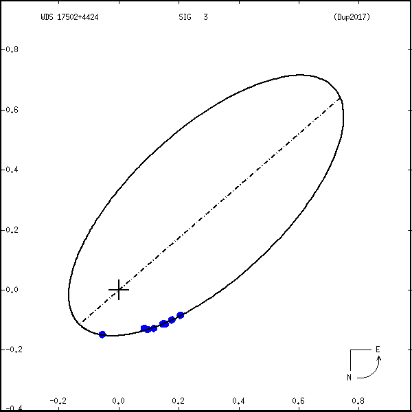
Measures: green=micrometric, blue=interferometric, purple=photographic |
|
WDS 17502+4424 SIG 3 : NOTES
| discov_num |
notes |
refcode |
| SIG 3 |
2MASSW J1750129+442404. |
|
|
Spectral types M7.5, M9.5. Estimated orbital period 36 +10/-9 yrs. |
Sig2003 |
|
Konopacky et al. (2010) derive a distance of 37.6 +/- 12.3 pc and a |
|
|
system mass of 0.20 +/- 0.12 Msun. |
Kon2010 |
REFERENCES
| refcode |
metd |
author |
reference |
| Dup2017 |
A j |
Dupuy, T.J. & Liu, M.C. |
2017ApJS..231...15D |
| Dup2017 |
+orb |
ApJS 231, 15, 2017 |
|
| Kon2010 |
Ag j |
Konopacky, Q.M., Ghez, A.M., Barman, T.S., Rice, E.L., Bailey, III, J.I., |
2010ApJ...711.1087K |
| Kon2010 |
|
White, R.J., McLean, I.S., & Duchene, G. |
|
| Kon2010 |
|
ApJ 711, 1087, 2010 |
|
| Sig2003 |
A j |
Siegler, N., Close, L.M., Mamajek, E.E., & Freed, M. |
2003ApJ...598.1265S |
| Sig2003 |
|
ApJ 598, 1265, 2003 |
|
WDS HISTORIC DATA
| coord_2000 |
discov_num |
comp |
epoch |
obs |
pa |
sep |
mag_pri |
mag_sec |
spectr |
notes |
coord_arcsec_2000 |
| 17502+4424 |
SIG 3 |
|
2002 |
1 |
340 |
0.2 |
13.20 |
14.00 |
|
N |
175012.91+442404.3 |
| 17502+4424 |
SIG 3 |
|
2009 |
7 |
60 |
0.2 |
13.20 |
14.00 |
M7.5+L0 |
NOD |
175012.91+442404.3 |
| 17502+4424 |
SIG 3 |
|
2010 |
12 |
68 |
0.2 |
13.20 |
14.00 |
M7.5+L0 |
NO K |
175012.91+442404.3 |
If you need more information about this double, apply for a
data request form to the WDS.
WDS 17502+4424 SIG 3 : VISUAL OBSERVATIONS REPORTS
No records found.
WDS 17502+4424 SIG 3 : MEASURES
No records found.
WDS 17502+4424 : VIRTUAL EYEPIECE

Click on the map to see the double of your interest.
Pass over with the mouse cursor to display the catalog designation.
|
|
WDS 17502+4424 : ALADIN DSS IMAGE @ 17h 50m 12.91s +44° 24' 04.3"
WDS 17502+4424 SIG 3 : NEIGHBORHOODS
|
|

Click on the map to see the double of your interest.
Pass over with the mouse cursor to display the catalog designation.
|
| Show |
name |
coord_2000 |
discov# |
comp |
pa |
sep |
dist(') |
| Show |
|
17502+4424 |
SIG 3 |
|
68 |
0.2 |
|
| Show |
|
17480+4406 |
KPP4061 |
|
26 |
4.2 |
30 |
| Show |
|
17512+4454 |
STF2242 |
AB |
325 |
3.4 |
33 |
| Show |
|
17512+4454 |
CTT 26 |
AC |
108 |
79.7 |
33 |
| Show |
|
17474+4409 |
CVR 206 |
|
303 |
10.7 |
34 |
| Show |
|
17469+4442 |
BRT 344 |
|
185 |
3.1 |
41 |
| Show |
|
17483+4506 |
SMA 79 |
|
92 |
15.3 |
47 |
| Show |
|
17514+4332 |
LDS4767 |
|
253 |
15.7 |
54 |
| Show |
|
17497+4325 |
LDS4764 |
|
41 |
50.5 |
59 |
| Show |
|
17446+4440 |
A 1882 |
|
57 |
2.0 |
63 |
| Show |
|
17533+4329 |
TDT 556 |
|
257 |
0.8 |
65 |
| Show |
|
17481+4324 |
KPP4062 |
|
74 |
1.8 |
65 |
| Show |
|
17556+4350 |
TDT 575 |
|
209 |
0.5 |
68 |
| Show |
|
17559+4351 |
ES 1415 |
|
130 |
1.7 |
70 |
| Show |
|
17526+4531 |
UC 233 |
|
94 |
24.3 |
72 |
| Show |
|
17536+4313 |
ES 2663 |
|
333 |
10.1 |
82 |
| Show |
|
17506+4547 |
SLW1214 |
|
25 |
22.2 |
83 |
| Show |
|
17433+4345 |
STF2214 |
AB |
210 |
19.9 |
84 |
| Show |
|
17433+4345 |
D 16 |
BC |
150 |
0.9 |
85 |
| Show |
|
17571+4343 |
KPP 404 |
|
293 |
3.7 |
85 |
| Show |
|
17422+4423 |
COU1596 |
|
104 |
0.2 |
86 |
| Show |
|
17425+4458 |
TDT 470 |
|
195 |
2.2 |
90 |
| Show |
|
17519+4256 |
COU1598 |
|
231 |
0.4 |
90 |
| Show |
|
17505+4554 |
KPP3323 |
|
213 |
1.6 |
91 |
| Show |
|
17454+4540 |
COU1597 |
|
301 |
1.0 |
91 |
| Show |
|
17439+4323 |
BWL 47 |
AB |
290 |
2.8 |
92 |
| Show |
|
17439+4323 |
BWL 47 |
AC |
314 |
9.2 |
92 |
| Show |
|
17516+4555 |
A 1883 |
|
41 |
0.6 |
93 |
| Show |
|
17593+4422 |
UC 3463 |
|
305 |
51.0 |
97 |
| Show |
|
17486+4606 |
CBL 518 |
|
34 |
19.8 |
104 |
| Show |
|
17428+4310 |
STF2209 |
|
127 |
29.8 |
110 |
| Show |
|
18001+4452 |
LDS4769 |
|
312 |
82.7 |
110 |
| Show |
|
17571+4303 |
CBL 520 |
|
111 |
35.8 |
111 |
| Show |
|
17571+4551 |
HU 235 |
|
289 |
1.8 |
114 |
| Show |
|
17567+4557 |
BVD 258 |
|
91 |
15.5 |
116 |
| Show |
|
17536+4234 |
COU1600 |
|
251 |
0.7 |
116 |
| Show |
|
17596+4314 |
COU1784 |
|
97 |
2.2 |
124 |
| Show |
|
17444+4615 |
TDS 879 |
|
37 |
1.4 |
127 |
| Show |
|
17453+4229 |
UC 3398 |
|
134 |
17.3 |
127 |
| Show |
|
17441+4613 |
A 1881 |
|
209 |
4.9 |
127 |
| Show |
|
18011+4521 |
STF3129 |
|
168 |
30.8 |
130 |
| Show |
|
18015+4517 |
STF2270 |
|
212 |
6.3 |
132 |
| Show |
|
17474+4633 |
WJD 2 |
|
108 |
2.4 |
132 |
| Show |
|
18025+4414 |
OLE 4 |
Aa,Ab |
319 |
0.1 |
133 |
| Show |
|
18025+4414 |
BU 1127 |
AB |
39 |
0.7 |
133 |
| Show |
|
17383+4500 |
ES 1257 |
AB |
296 |
2.7 |
133 |
| Show |
|
17383+4500 |
ES 1257 |
AC |
124 |
52.3 |
133 |
| Show |
|
17389+4522 |
ES 1258 |
|
317 |
12.2 |
134 |
| Show |
|
17471+4215 |
A 697 |
|
128 |
0.4 |
134 |
| Show |
|
18022+4506 |
CBL 73 |
|
293 |
31.7 |
135 |
| Show |
|
17557+4626 |
BAR 43 |
AB |
253 |
2.0 |
135 |
|
|
WDS 17502+4424 : COMPONENTS
17502+4424 A
| Componente originario normalizzato |
AB |
|
Coord arcsec 2000 |
175012.91+442404.3 |
|
Mag |
13.2 |
|
Spectral class |
M7.5 (red) |
|
| PmRA |
-14.00 |
|
PmDE |
138.0 |
|
17502+4424 B
| Componente originario normalizzato |
AB |
|
Coord arcsec 2000 |
175012.92+442404.4 |
|
Mag |
14 |
|
Spectral class |
L0 (very deep red) |
|
| Calc delta mag |
0.8 |
|
Calc coord |
yes |
|