17313+1901 COU 499 (HD 158956)
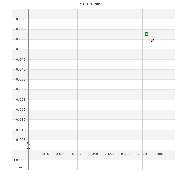
17h 31m 17.44s +19° 01' 02.8" P.A. 304.00 sep 0.1 mag 8.70,8.70 Sp A5 dist. 446.43 pc (1456.25 l.y.)
| Coord 2000 |
17313+1901 |
|
Discov num |
COU 499 |
|
Comp |
|
|
Coord arcsec 2000 |
17 31 17.44 +19 01 02.8 |
|
| Date first |
1970 |
|
Date last |
2021 |
|
Obs |
26 |
|
| Pa first |
90 |
|
Pa last |
304.2 |
|
P.A. Now (θ) |
304.2° |
|
| Sep first |
0.2 |
|
Sep last |
0.097 |
|
Sep. Now (ρ) |
0.097" |
|
| Mag pri |
8.70 |
|
Mag sec |
8.70 |
|
delta mag (ΔM) |
0 |
|
Spectral class |
A5 (white) |
|
| Pri motion ra |
-012 |
|
Sec motion ra |
|
|
| Pri motion dec |
-028 |
|
Sec motion dec |
|
|
| Notes |
O
(Orbital solution) |
|
This double is physical.
OTHER CATALOGS AND DESIGNATIONS
| Name |
HD 158956 |
|
Constellation |
Hercules |
|
SAO |
102882 |
|
HIP |
85740 |
|
| Tycho2 |
1546-01390-1 |
|
Gaia DR2 |
4553813709233975808 |
|
HD |
158956 |
|
BD |
BD+19 3336 |
|
| Distance |
446.43 |
|
Distance ly |
1456.25 |
|
ORBITAL ELEMENTS
| Period (P) | 316.83y | |
Periastron (T) | 2003.65y | |
Semi-major axis (a) | 0.284a | |
| Eccentricity (e) | 0.5 | |
Inclination (i) | 124.6° | |
Longitude of periastron (ω) | 216.5° | |
| Node (Ω) | 225.1° | |
Notes | | |
Reference | Tok2017c | |
| Equinox | 2000 | |
Last observation | 2017 | |
Grade | 5 | (1=Definitive, 9=Indet.) |
| label |
theta |
rho |
| 2000 |
32.0 |
0.136 |
| 2001 |
29.5 |
0.133 |
| 2002 |
26.9 |
0.130 |
| 2003 |
24.2 |
0.126 |
| 2004 |
21.3 |
0.123 |
| 2005 |
18.2 |
0.119 |
| 2006 |
14.9 |
0.115 |
| 2007 |
11.4 |
0.112 |
| 2008 |
7.6 |
0.108 |
| 2009 |
3.7 |
0.105 |
| 2010 |
359.4 |
0.102 |
| 2011 |
354.9 |
0.099 |
| 2012 |
350.2 |
0.096 |
| 2013 |
345.2 |
0.094 |
| 2014 |
340.1 |
0.093 |
| 2015 |
334.8 |
0.092 |
| 2016 |
329.4 |
0.091 |
| 2017 |
324.0 |
0.092 |
| 2018 |
318.7 |
0.092 |
| 2019 |
313.5 |
0.094 |
| 2020 |
308.4 |
0.096 |
| 2021 |
303.6 |
0.098 |
| 2022 |
299.1 |
0.101 |
| 2023 |
294.8 |
0.104 |
| 2024 |
290.8 |
0.108 |
| 2025 |
287.1 |
0.112 |
| 2026 |
283.6 |
0.117 |
| 2027 |
280.5 |
0.121 |
| 2028 |
277.5 |
0.126 |
| 2029 |
274.8 |
0.131 |
| 2030 |
272.2 |
0.136 |
|
|
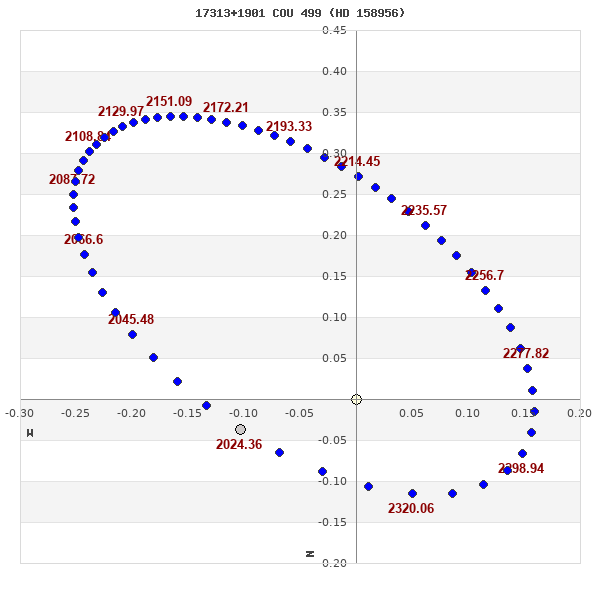
Note: Theta is PA, Rho is Sep. For yearly orbits, data refer to Jan 1st.
|
|
|
|
|
|
|
|
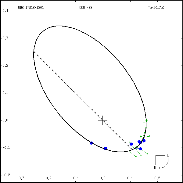
Measures: green=micrometric, blue=interferometric, purple=photographic |
|
WDS 17313+1901 COU 499 (HD 158956) : NOTES
No records found.
REFERENCES
| refcode |
metd |
author |
reference |
| Tok2017c |
orb - |
Tokovinin, A. |
2017IAUDS.193....1T |
| Tok2017c |
|
Inf. Circ. 193, 1, 2017 |
|
DISCOVERER
| idgroup |
discov |
author |
| 1 |
COU |
Couteau, P. |
WDS HISTORIC DATA
| coord_2000 |
discov_num |
comp |
epoch |
obs |
pa |
sep |
mag_pri |
mag_sec |
spectr |
notes |
coord_arcsec_2000 |
| 17313+1901 |
COU 499 |
|
1996 |
18 |
43 |
0.2 |
8.70 |
8.70 |
A5 |
O |
173117.44+190102.8 |
| 17313+1901 |
COU 499 |
|
2007 |
19 |
5 |
0.1 |
8.70 |
8.70 |
A5 |
O |
173117.44+190102.8 |
| 17313+1901 |
COU 499 |
|
2015 |
20 |
333 |
0.1 |
8.70 |
8.70 |
A5 |
O |
173117.44+190102.8 |
| 17313+1901 |
COU 499 |
|
2017 |
21 |
321 |
0.1 |
8.70 |
8.70 |
A5 |
O |
173117.44+190102.8 |
| 17313+1901 |
COU 499 |
|
2018 |
22 |
315 |
0.1 |
8.70 |
8.70 |
A5 |
O |
173117.44+190102.8 |
| 17313+1901 |
COU 499 |
|
2021 |
25 |
304 |
0.1 |
8.70 |
8.70 |
A5 |
O |
173117.44+190102.8 |
If you need more information about this double, apply for a
data request form to the WDS.
WDS 17313+1901 COU 499 (HD 158956) : VISUAL OBSERVATIONS REPORTS
No records found.
WDS 17313+1901 COU 499 (HD 158956) : MEASURES
No records found.
WDS 17313+1901 (HD 158956) : VIRTUAL EYEPIECE
Click on the map to see the double of your interest.
Pass over with the mouse cursor to display the catalog designation.
|
|
WDS 17313+1901 (HD 158956) : ALADIN DSS IMAGE @ 17h 31m 17.44s +19° 01' 02.8"
WDS 17313+1901 COU 499 (HD 158956) : NEIGHBORHOODS
|
|

Click on the map to see the double of your interest.
Pass over with the mouse cursor to display the catalog designation.
|
| Show |
name |
coord_2000 |
discov# |
comp |
pa |
sep |
dist(') |
| Show |
|
17313+1901 |
COU 499 |
|
304 |
0.1 |
1 |
| Show |
|
17304+1913 |
RAO 373 |
|
225 |
2.5 |
18 |
| Show |
|
17298+1902 |
NSN 691 |
|
181 |
37.8 |
22 |
| Show |
|
17332+1900 |
GRV 960 |
|
61 |
29.4 |
28 |
| Show |
|
17296+1945 |
HO 632 |
|
197 |
6.7 |
50 |
| Show |
|
17297+1815 |
BRT2433 |
|
308 |
4.5 |
51 |
| Show |
|
17353+1853 |
KPP3319 |
|
343 |
3.2 |
58 |
| Show |
|
17267+1904 |
GRV 954 |
|
261 |
58.1 |
64 |
| Show |
|
17274+1941 |
GRV 955 |
|
274 |
15.3 |
68 |
| Show |
|
17336+1801 |
BPM 688 |
|
169 |
99.6 |
69 |
| Show |
|
17348+1812 |
TDT 422 |
|
139 |
0.5 |
71 |
| Show |
|
17285+1755 |
TDT 370 |
|
119 |
0.5 |
77 |
| Show |
|
17338+2013 |
UC 3368 |
|
156 |
81.6 |
81 |
| Show |
|
17339+1747 |
COU 627 |
|
145 |
2.2 |
84 |
| Show |
|
17261+1957 |
GRV 953 |
|
153 |
6.8 |
92 |
| Show |
|
17248+1843 |
UC 3337 |
|
192 |
31.7 |
94 |
| Show |
|
17291+1727 |
DAL 14 |
AB |
88 |
2.4 |
99 |
| Show |
|
17291+1727 |
DAL 14 |
AC |
184 |
18.2 |
99 |
| Show |
|
17372+1809 |
TDT 436 |
|
184 |
0.1 |
99 |
| Show |
|
17387+1834 |
OSO 82 |
CD |
202 |
9.9 |
103 |
| Show |
|
17387+1834 |
BUP 177 |
BC |
270 |
104.9 |
105 |
| Show |
|
17249+1806 |
BPMA 50 |
|
145 |
151.2 |
106 |
| Show |
|
17387+1840 |
SLO 1 |
AB |
219 |
1.7 |
107 |
| Show |
|
17387+1840 |
SLO 1 |
AC |
149 |
146.3 |
107 |
| Show |
|
17387+1834 |
BUP 177 |
AB |
266 |
272.2 |
109 |
| Show |
|
17387+1834 |
BUP 177 |
AC |
269 |
374.3 |
109 |
| Show |
|
17290+2046 |
TDT 376 |
|
305 |
0.7 |
110 |
| Show |
|
17376+1747 |
BPM 690 |
|
210 |
65.8 |
117 |
| Show |
|
17309+2106 |
TDT 392 |
|
136 |
1.8 |
126 |
| Show |
|
17316+1654 |
BPM 684 |
|
242 |
90.7 |
128 |
| Show |
|
17375+2036 |
GAU 21 |
AB |
4 |
16.0 |
129 |
| Show |
|
17339+1655 |
LDT 22 |
|
63 |
0.4 |
132 |
| Show |
|
17319+1649 |
TOK 314 |
|
323 |
174.7 |
132 |
| Show |
|
17360+2100 |
STF2190 |
AB |
22 |
10.4 |
136 |
| Show |
|
17360+2100 |
WAL 83 |
AC |
37 |
76.8 |
136 |
| Show |
|
17267+2101 |
BRT2432 |
|
351 |
2.7 |
137 |
| Show |
|
17259+1655 |
KUI 81 |
AB |
216 |
8.5 |
148 |
| Show |
|
17259+1655 |
KUI 81 |
AC |
220 |
26.8 |
148 |
| Show |
|
17306+2129 |
LDS4748 |
|
283 |
15.2 |
149 |
| Show |
|
17406+2017 |
AG 211 |
|
130 |
2.7 |
152 |
| Show |
|
17297+1629 |
BPM 683 |
|
323 |
101.8 |
154 |
| Show |
|
17250+2109 |
JNN 113 |
|
24 |
3.5 |
156 |
| Show |
|
17275+1627 |
A 2184 |
AB |
41 |
1.6 |
163 |
| Show |
|
17275+1627 |
LBU 5 |
AC |
259 |
49.3 |
163 |
| Show |
|
17387+2106 |
KPP3320 |
|
250 |
1.7 |
164 |
| Show |
|
17336+1618 |
LDS4752 |
|
145 |
3.0 |
167 |
| Show |
|
17299+2147 |
TDT 382 |
|
288 |
0.3 |
168 |
| Show |
|
17319+1613 |
LDS 996 |
|
283 |
178.8 |
169 |
| Show |
|
17235+1654 |
A 2183 |
AB |
137 |
1.2 |
169 |
| Show |
|
17224+2056 |
COU 201 |
AB |
258 |
0.5 |
170 |
| Show |
|
17224+2056 |
COU 201 |
AC |
301 |
10.3 |
170 |
|
|
WDS 17313+1901 : COMPONENTS
17313+1901 A
| Componente originario normalizzato |
AB |
|
Name |
HD 158956 |
|
Coord arcsec 2000 |
173117.44+190102.8 |
|
Mag |
8.7 |
|
| Spectral class |
A5 (white) |
|
PmRA |
-12.00 |
|
PmDE |
-28.0 |
|
SAO |
102882 |
|
| HIP |
85740 |
|
Tycho2 |
1546-01390-1 |
|
HD |
158956 |
|
BD |
BD+19 3336 |
|
| Tycho2 |
1546-01390-1 |
|
Pflag |
|
|
RAmdeg |
262.82264579 |
|
DEmdeg |
19.01738344 |
|
| PmRA |
-5.2 |
|
PmDE |
-27.9 |
|
E RAmdeg |
8 |
|
E DEmdeg |
8 |
|
| E pmRA |
1.1 |
|
E pmDE |
1.1 |
|
EpRAm |
1990.78 |
|
EpDEm |
1990.77 |
|
| Num |
10 |
|
Q RAmdeg |
0.8 |
|
Q DEmdeg |
1.0 |
|
Q pmRA |
0.8 |
|
| Q pmDE |
1.0 |
|
BTmag |
9.385 |
|
E BTmag |
0.019 |
|
VTmag |
9.002 |
|
| E VTmag |
0.015 |
|
Prox |
999 |
|
TYC |
T |
|
HIP |
85740 |
|
| CCDM |
|
|
RAdeg |
262.82265917 |
|
DEdeg |
19.01744833 |
|
EpRA 1990 |
1.64 |
|
| EpDE 1990 |
1.67 |
|
E RAdeg |
8.3 |
|
E DEdeg |
8.3 |
|
Posflg |
|
|
| Corr |
-0.1 |
|
| SAO |
102882 |
|
DelFlag |
|
|
RA1950 |
|
|
PmRA1950 |
0.0003 |
|
| DE1950 |
|
|
PmDE1950 |
-0.047 |
|
Vmag |
8.7 |
|
SpType |
A5 |
|
| Double code |
|
|
Source |
28 |
|
CatNum |
6308 |
|
DM |
BD+19 3336 |
|
| DMcomp |
|
|
BDsup |
|
|
HD |
158956 |
|
M HD |
0 |
|
| GC |
|
|
RA1950rad |
4.57760319 |
|
DE1950rad |
0.33254926 |
|
PmRA2000 |
0.0004 |
|
| PmDE2000 |
-0.045 |
|
| Catalog |
H |
|
HIP |
85740 |
|
Proxy |
|
|
RAhms |
17 31 17.44 |
|
| DEdms |
+19 01 02.8 |
|
Vmag |
8.98 |
|
VarFlag |
|
|
R Vmag |
G |
|
| RAdeg |
262.823 |
|
DEdeg |
19.0175 |
|
AstroRef |
|
|
Plx |
4.25 |
|
| CCDM |
17313+1901 |
|
N CCDM |
I |
|
Nsys |
1 |
|
Ncomp |
1 |
|
| MultFlag |
|
|
Source |
|
|
Qual |
S |
|
M HIP |
|
|
| Theta |
|
|
Rho |
|
|
HD |
158956 |
|
BD |
BD+19 3336 |
|
| CD |
|
|
CP |
|
|
Dm number |
+19 3336 |
|
VIred |
1.53 |
|
| SpType |
A5 |
|
R SpType |
|
|
Coord arcsec 2000 |
173117.44+190102.8 |
|
| HIP |
85740 |
|
Sn |
5 |
|
So |
0 |
|
Nc |
1 |
|
| RArad |
4.5871206092 |
|
DErad |
0.3319171274 |
|
Plx |
2.24 |
|
PmRA |
-1.71 |
|
| PmDE |
-27.35 |
|
E RArad |
0.93 |
|
E DErad |
0.99 |
|
E Plx |
1.32 |
|
| E pmRA |
1.31 |
|
E pmDE |
1.15 |
|
Hpmag |
9.0329 |
|
E Hpmag |
0.0049 |
|
| SHp |
0.042 |
|
VA |
0 |
|
BV |
0.361 |
|
E BV |
0.013 |
|
| VI |
0.42 |
|
| Ccdm |
17313+1901 |
|
RComp |
|
|
Comp |
A |
|
Note1 |
|
|
| Note2 |
|
|
Discov num |
|
|
DRAs |
-0.55 |
|
DDEs |
2.5 |
|
| R dRAs |
10 |
|
Year |
|
|
Theta |
|
|
Rho |
|
|
| Obs |
2 |
|
Vmag |
8.7 |
|
Sp |
A5 |
|
PmNote |
* |
|
| PmRA |
-1 |
|
PmDE |
-29 |
|
Dm number |
+19 3336 |
|
Cat1 |
BD |
|
| Name2 |
+19 1620 |
|
Cat2 |
AGK2/3 |
|
HD |
158956 |
|
M HD |
|
|
| ADS BDS |
|
|
M ADS BDS |
|
|
N IDS |
|
|
IDS |
17269N1905A |
|
| HIC |
85740 |
|
17313+1901 B
| Componente originario normalizzato |
AB |
|
Coord arcsec 2000 |
173117.43+190102.9 |
|
Mag |
8.7 |
|
Calc coord |
yes |
|
| Ccdm |
17313+1901 |
|
RComp |
|
|
Comp |
B |
|
Note1 |
|
|
| Note2 |
|
|
Discov num |
COU 499 |
|
DRAs |
|
|
DDEs |
|
|
| R dRAs |
|
|
Year |
1970 |
|
Theta |
88 |
|
Rho |
0.2 |
|
| Obs |
1 |
|
Vmag |
8.7 |
|
Sp |
|
|
PmNote |
|
|
| PmRA |
|
|
PmDE |
|
|
Dm number |
|
|
Cat1 |
|
|
| Name2 |
|
|
Cat2 |
|
|
HD |
|
|
M HD |
|
|
| ADS BDS |
|
|
M ADS BDS |
|
|
N IDS |
|
|
IDS |
17269N1905B |
|
| HIC |
85740 |
|