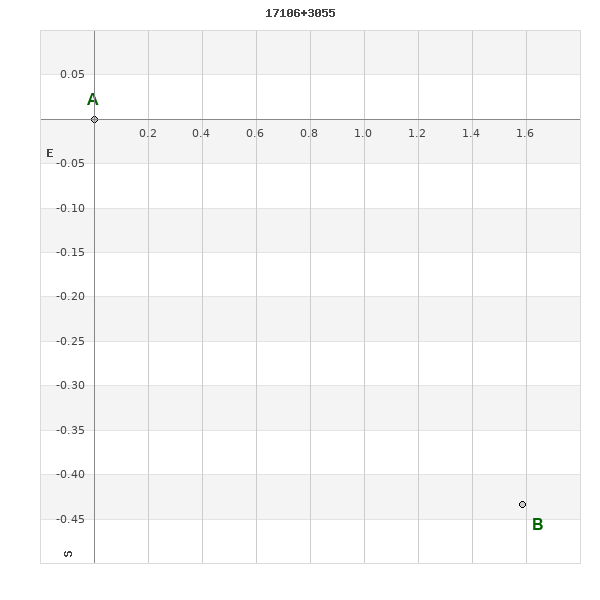
17106+3055 TDT 248
17h 10m 38.85s +30° 55' 22.2" P.A. 257.00 sep 1.9 mag 12.03,12.55
| Coord 2000 |
17106+3055 |
|
Discov num |
TDT 248 |
|
Comp |
|
|
Coord arcsec 2000 |
17 10 38.85 +30 55 22.2 |
|
| Date first |
1991 |
|
Date last |
1991 |
|
Obs |
1 |
|
| Pa first |
257 |
|
Pa last |
256.8 |
|
P.A. Now (θ) |
256.8° |
|
| Sep first |
1.9 |
|
Sep last |
1.9 |
|
Sep. Now (ρ) |
1.9" |
|
| Mag pri |
12.03 |
|
Mag sec |
12.55 |
|
delta mag (ΔM) |
0.52 |
|
Spectral class |
|
|
| Pri motion ra |
-010 |
|
Sec motion ra |
-010 |
|
| Pri motion dec |
-004 |
|
Sec motion dec |
-004 |
|
| Notes |
|
|
Nature of this double is uncertain.
OTHER CATALOGS AND DESIGNATIONS
| Constellation |
Hercules |
|
Tycho2 |
2591-01724-1 |
|
Gaia DR2 |
1309350162058992128 |
|
WDS 17106+3055 TDT 248 : NOTES
No records found.
REFERENCES
No records found.
WDS HISTORIC DATA
| coord_2000 |
discov_num |
comp |
epoch |
obs |
pa |
sep |
mag_pri |
mag_sec |
spectr |
notes |
coord_arcsec_2000 |
| 17106+3055 |
TDT 248 |
|
1991 |
1 |
257 |
1.9 |
12.03 |
12.55 |
|
|
171038.85+305522.2 |
If you need more information about this double, apply for a
data request form to the WDS.
WDS 17106+3055 TDT 248 : VISUAL OBSERVATIONS REPORTS
No records found.
WDS 17106+3055 TDT 248 : MEASURES
No records found.
WDS 17106+3055 : VIRTUAL EYEPIECE
Click on the map to see the double of your interest.
Pass over with the mouse cursor to display the catalog designation.
|
|
WDS 17106+3055 : ALADIN DSS IMAGE @ 17h 10m 38.85s +30° 55' 22.2"
WDS 17106+3055 TDT 248 : NEIGHBORHOODS
|
|
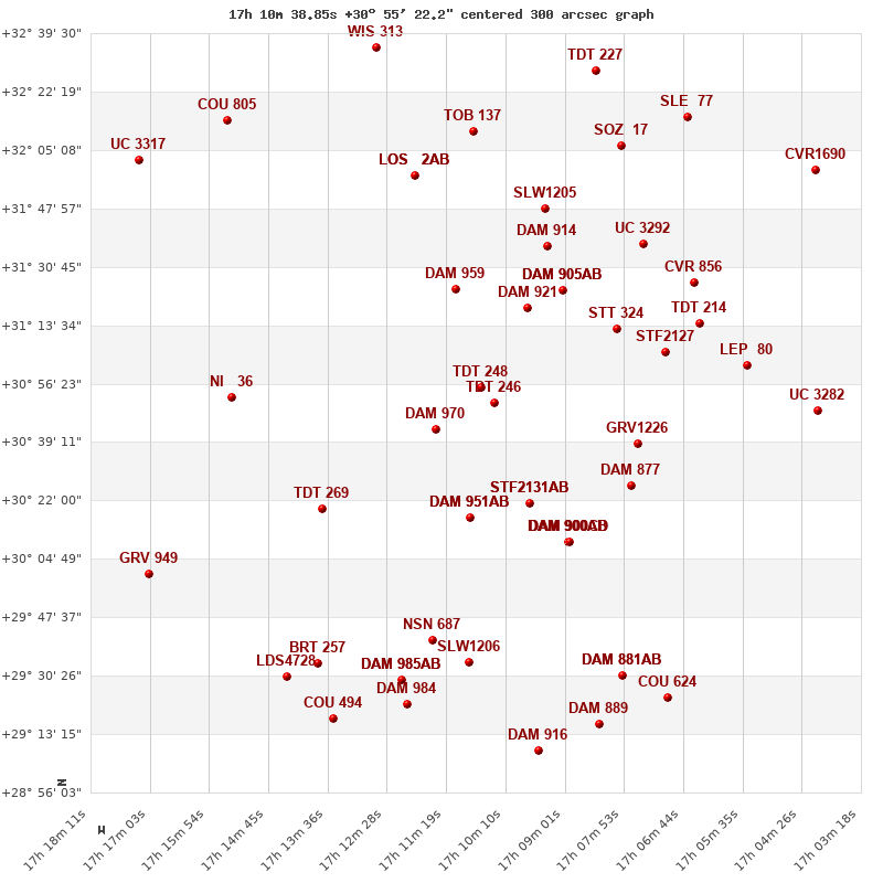
Click on the map to see the double of your interest.
Pass over with the mouse cursor to display the catalog designation.
|
| Show |
name |
coord_2000 |
discov# |
comp |
pa |
sep |
dist(') |
| Show |
|
17106+3055 |
TDT 248 |
|
257 |
1.9 |
|
| Show |
|
17104+3051 |
TDT 246 |
|
277 |
0.5 |
6 |
| Show |
|
17115+3043 |
DAM 970 |
|
298 |
3.8 |
17 |
| Show |
|
17097+3119 |
DAM 921 |
|
26 |
7.3 |
26 |
| Show |
|
17111+3124 |
DAM 959 |
|
199 |
1.9 |
30 |
| Show |
|
17091+3124 |
DAM 905 |
AB |
331 |
1.1 |
35 |
| Show |
|
17091+3124 |
DAM 905 |
AC |
174 |
3.3 |
35 |
| Show |
|
17097+3021 |
STF2131 |
AB |
178 |
24.3 |
37 |
| Show |
|
17097+3021 |
ARN 46 |
AC |
335 |
140.4 |
37 |
| Show |
|
17080+3112 |
STT 324 |
|
222 |
3.6 |
38 |
| Show |
|
17109+3017 |
DAM 951 |
AB |
198 |
3.7 |
39 |
| Show |
|
17109+3017 |
DAM 951 |
AC |
102 |
10.5 |
39 |
| Show |
|
17076+3038 |
GRV1226 |
|
267 |
22.1 |
43 |
| Show |
|
17094+3137 |
DAM 914 |
|
287 |
6.0 |
45 |
| Show |
|
17071+3106 |
STF2127 |
|
281 |
15.1 |
48 |
| Show |
|
17077+3026 |
DAM 877 |
|
138 |
2.7 |
48 |
| Show |
|
17090+3010 |
DAM 900 |
AB |
270 |
5.8 |
51 |
| Show |
|
17090+3010 |
DAM 900 |
AC |
255 |
20.6 |
51 |
| Show |
|
17090+3010 |
DAM 900 |
CD |
150 |
1.0 |
51 |
| Show |
|
17137+3020 |
TDT 269 |
|
12 |
0.6 |
54 |
| Show |
|
17094+3148 |
SLW1205 |
|
257 |
147.6 |
55 |
| Show |
|
17064+3114 |
TDT 214 |
|
354 |
0.7 |
58 |
| Show |
|
17075+3137 |
UC 3292 |
|
37 |
18.7 |
59 |
| Show |
|
17065+3126 |
CVR 856 |
|
172 |
18.7 |
62 |
| Show |
|
17155+3053 |
NI 36 |
|
347 |
14.9 |
63 |
| Show |
|
17120+3158 |
LOS 2 |
AB |
44 |
11.6 |
65 |
| Show |
|
17120+3158 |
GYL 5 |
AC |
321 |
16.9 |
65 |
| Show |
|
17055+3102 |
LEP 80 |
|
269 |
23.6 |
67 |
| Show |
|
17108+3211 |
TOB 137 |
|
262 |
40.9 |
76 |
| Show |
|
17116+2941 |
NSN 687 |
|
117 |
11.9 |
76 |
| Show |
|
17079+3206 |
SOZ 17 |
|
197 |
6.5 |
80 |
| Show |
|
17109+2934 |
SLW1206 |
|
303 |
81.6 |
81 |
| Show |
|
17041+3048 |
UC 3282 |
|
330 |
8.4 |
85 |
| Show |
|
17122+2929 |
DAM 985 |
AB |
135 |
1.2 |
89 |
| Show |
|
17122+2929 |
DAM 985 |
AC |
100 |
7.4 |
89 |
| Show |
|
17135+2935 |
BRT 257 |
|
182 |
5.8 |
91 |
| Show |
|
17079+2931 |
DAM 881 |
AB |
26 |
2.8 |
92 |
| Show |
|
17079+2931 |
DAM 881 |
AC |
306 |
5.1 |
92 |
| Show |
|
17066+3215 |
SLE 77 |
|
268 |
19.7 |
95 |
| Show |
|
17121+2922 |
DAM 984 |
|
331 |
1.8 |
96 |
| Show |
|
17084+3229 |
TDT 227 |
|
230 |
2.3 |
98 |
| Show |
|
17145+2931 |
LDS4728 |
|
309 |
2.4 |
99 |
| Show |
|
17170+3000 |
GRV 949 |
|
277 |
10.6 |
100 |
| Show |
|
17152+3214 |
COU 805 |
|
235 |
0.9 |
101 |
| Show |
|
17071+2923 |
COU 624 |
|
274 |
3.5 |
103 |
| Show |
|
17127+3235 |
WIS 313 |
|
273 |
999.9 |
104 |
| Show |
|
17084+2916 |
DAM 889 |
|
264 |
2.2 |
104 |
| Show |
|
17135+2918 |
COU 494 |
|
354 |
1.6 |
105 |
| Show |
|
17042+3159 |
CVR1690 |
|
238 |
3.5 |
105 |
| Show |
|
17173+3202 |
UC 3317 |
|
359 |
10.4 |
108 |
| Show |
|
17095+2909 |
DAM 916 |
|
344 |
2.6 |
108 |
|
|
WDS 17106+3055 : COMPONENTS
17106+3055 A
| Componente originario normalizzato |
AB |
|
Coord arcsec 2000 |
171038.85+305522.2 |
|
Mag |
12.03 |
|
PmRA |
-10.00 |
|
| PmDE |
-4.0 |
|
Tycho2 |
2591-01724-1 |
|
| Tycho2 |
2591-01724-1 |
|
Pflag |
|
|
RAmdeg |
257.66182656 |
|
DEmdeg |
30.92281554 |
|
| PmRA |
-9.5 |
|
PmDE |
-3.8 |
|
E RAmdeg |
74 |
|
E DEmdeg |
71 |
|
| E pmRA |
2.6 |
|
E pmDE |
2.5 |
|
EpRAm |
1980.23 |
|
EpDEm |
1980.15 |
|
| Num |
4 |
|
Q RAmdeg |
0.6 |
|
Q DEmdeg |
2.2 |
|
Q pmRA |
0.6 |
|
| Q pmDE |
2.2 |
|
BTmag |
12.758 |
|
E BTmag |
0.205 |
|
VTmag |
12.000 |
|
| E VTmag |
0.152 |
|
Prox |
797 |
|
TYC |
|
|
HIP |
|
|
| CCDM |
|
|
RAdeg |
257.66185083 |
|
DEdeg |
30.92281944 |
|
EpRA 1990 |
1.68 |
|
| EpDE 1990 |
1.63 |
|
E RAdeg |
79.8 |
|
E DEdeg |
76.5 |
|
Posflg |
|
|
| Corr |
0.0 |
|
17106+3055 B
| Componente originario normalizzato |
AB |
|
Coord arcsec 2000 |
171038.73+305521.8 |
|
Mag |
12.55 |
|
PmRA |
-10.00 |
|
| PmDE |
-4.0 |
|
Calc delta mag |
0.52 |
|
Calc coord |
yes |
|