11556-1815 RST 2773
11h 55m 36.06s -18° 14' 42.4" P.A. 332.00 sep 2.3 mag 11.10,11.10
| Coord 2000 |
11556-1815 |
|
Discov num |
RST2773 |
|
Comp |
|
|
Coord arcsec 2000 |
11 55 36.06 -18 14 42.4 |
|
| Date first |
1935 |
|
Date last |
2016 |
|
Obs |
5 |
|
| Pa first |
333 |
|
Pa last |
332.2 |
|
P.A. Now (θ) |
332.2° |
|
| Sep first |
2.2 |
|
Sep last |
2.313 |
|
Sep. Now (ρ) |
2.313" |
|
| Mag pri |
11.10 |
|
Mag sec |
11.10 |
|
delta mag (ΔM) |
0 |
|
Spectral class |
|
|
| Pri motion ra |
-017 |
|
Sec motion ra |
|
|
| Pri motion dec |
-012 |
|
Sec motion dec |
|
|
| Notes |
|
|
Nature of this double is uncertain.
OTHER CATALOGS AND DESIGNATIONS
| Constellation |
Crater |
|
Tycho2 |
6097-00656-1 |
|
Gaia DR2 |
3567223093859946496 |
|
WDS 11556-1815 RST 2773 : NOTES
No records found.
REFERENCES
| refcode |
metd |
author |
reference |
| Rst1933 |
T - |
Rossiter, R.A. |
1933MmRAS..65...27R |
| Rst1933 |
|
MemRAS 65, 27, 1933 |
|
| Rst1937 |
Ma - |
Rossiter, R.A. |
1937MmRAS..65...51R |
| Rst1937 |
|
MemRAS 65, 51, 1937 |
|
| Rst1943 |
Ma - |
Rossiter, R.A. |
1943POMic...8..133R |
| Rst1943 |
|
Pub. Univ. Michigan Obs. 8, 133, 1943 |
|
| Rst1944 |
- |
Rossiter, R.A. |
1944POMic...9....1R |
| Rst1944 |
|
Pub. Univ. Michigan Obs. 9, 1, 1944 |
|
| Rst1947 |
Ma - |
Rossiter, R.A. |
1947POMic...9....7R |
| Rst1947 |
|
Pub. Univ. Michigan Obs. 9, 7, 1947 |
|
| Rst1955 |
Ma j |
Rossiter, R.A. |
1955POMic..11....1R |
| Rst1955 |
+P+ |
Pub. Univ. Michigan Obs. 11, 1, 1955 |
|
| Rst1964 |
Ma - |
Rossiter, R.A. |
1964POMic...9...73R |
| Rst1964 |
|
Pub. Univ. Michigan Obs. 9, 73, 1964 |
|
WDS HISTORIC DATA
| coord_2000 |
discov_num |
comp |
epoch |
obs |
pa |
sep |
mag_pri |
mag_sec |
spectr |
notes |
coord_arcsec_2000 |
| 11556-1815 |
RST2773 |
|
2005 |
3 |
336 |
2.3 |
11.10 |
11.10 |
|
|
115536.06-181442.4 |
| 11556-1815 |
RST2773 |
|
2016 |
4 |
332 |
2.3 |
11.10 |
11.10 |
|
|
115536.06-181442.4 |
If you need more information about this double, apply for a
data request form to the WDS.
WDS 11556-1815 RST 2773 : VISUAL OBSERVATIONS REPORTS
No records found.
WDS 11556-1815 RST 2773 : MEASURES
No records found.
WDS 11556-1815 : VIRTUAL EYEPIECE
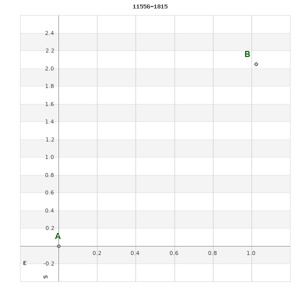
Click on the map to see the double of your interest.
Pass over with the mouse cursor to display the catalog designation.
|
|
WDS 11556-1815 : ALADIN DSS IMAGE @ 11h 55m 36.06s -18° 14' 42.4"
WDS 11556-1815 RST 2773 : NEIGHBORHOODS
|
|
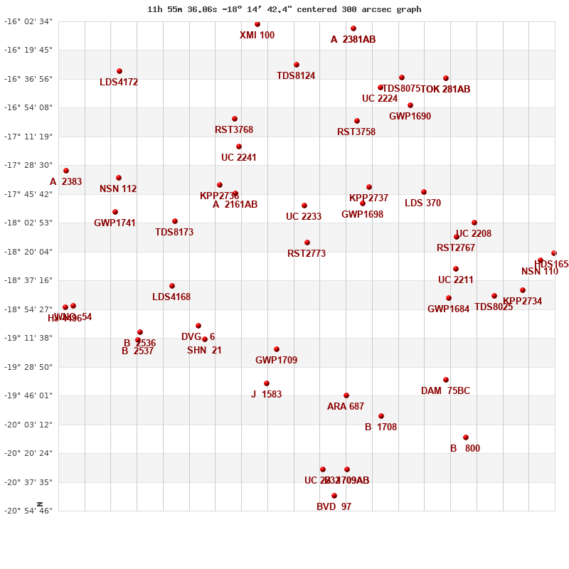
Click on the map to see the double of your interest.
Pass over with the mouse cursor to display the catalog designation.
|
| Show |
name |
coord_2000 |
discov# |
comp |
pa |
sep |
dist(') |
| Show |
|
11556-1815 |
RST2773 |
|
332 |
2.3 |
|
| Show |
|
11557-1752 |
UC 2233 |
|
7 |
60.2 |
23 |
| Show |
|
11532-1751 |
GWP1698 |
|
140 |
120.2 |
42 |
| Show |
|
11529-1741 |
KPP2737 |
|
320 |
6.2 |
52 |
| Show |
|
11588-1746 |
A 2161 |
AB |
326 |
5.1 |
54 |
| Show |
|
11594-1740 |
KPP2736 |
|
24 |
1.6 |
65 |
| Show |
|
11569-1918 |
GWP1709 |
|
135 |
45.9 |
67 |
| Show |
|
11586-1717 |
UC 2241 |
|
279 |
7.4 |
72 |
| Show |
|
11534-1702 |
RST3758 |
|
92 |
1.8 |
79 |
| Show |
|
11505-1744 |
LDS 370 |
|
58 |
19.1 |
80 |
| Show |
|
12014-1802 |
TDS8173 |
|
217 |
0.8 |
84 |
| Show |
|
12004-1904 |
DVG 6 |
|
325 |
4.0 |
84 |
| Show |
|
12001-1912 |
SHN 21 |
|
276 |
0.1 |
86 |
| Show |
|
11588-1701 |
RST3768 |
|
265 |
3.7 |
87 |
| Show |
|
11574-1939 |
J 1583 |
|
72 |
8.4 |
88 |
| Show |
|
12015-1840 |
LDS4168 |
|
273 |
1.8 |
89 |
| Show |
|
11490-1811 |
RST2767 |
|
170 |
0.7 |
94 |
| Show |
|
11491-1831 |
UC 2211 |
|
205 |
19.3 |
95 |
| Show |
|
11539-1945 |
ARA 687 |
|
65 |
7.8 |
95 |
| Show |
|
11494-1848 |
GWP1684 |
|
320 |
16.7 |
95 |
| Show |
|
11524-1642 |
UC 2224 |
|
297 |
9.2 |
104 |
| Show |
|
11511-1653 |
GWP1690 |
|
190 |
77.8 |
105 |
| Show |
|
11483-1803 |
UC 2208 |
|
273 |
13.2 |
106 |
| Show |
|
11561-1628 |
TDS8124 |
|
270 |
0.5 |
107 |
| Show |
|
11523-1958 |
B 1708 |
|
270 |
0.2 |
114 |
| Show |
|
11514-1636 |
TDS8075 |
|
134 |
0.5 |
116 |
| Show |
|
12029-1908 |
B 2536 |
|
288 |
2.6 |
117 |
| Show |
|
11495-1937 |
DAM 75 |
BC |
77 |
15.0 |
119 |
| Show |
|
11495-1937 |
LDS 368 |
AB |
91 |
9.1 |
120 |
| Show |
|
11495-1937 |
NVL 6 |
AD |
232 |
32.9 |
120 |
| Show |
|
12030-1913 |
B 2537 |
|
259 |
2.1 |
121 |
| Show |
|
11474-1847 |
TDS8025 |
|
17 |
0.9 |
121 |
| Show |
|
12040-1756 |
GWP1741 |
|
213 |
26.4 |
122 |
| Show |
|
12039-1736 |
NSN 112 |
|
111 |
16.1 |
125 |
| Show |
|
11536-1607 |
A 2381 |
AB |
355 |
4.6 |
132 |
| Show |
|
11536-1607 |
A 2381 |
AC |
319 |
71.5 |
132 |
| Show |
|
11495-1636 |
TOK 281 |
AB |
20 |
406.5 |
132 |
| Show |
|
11495-1636 |
TOK 717 |
Aa,Ab |
113 |
0.2 |
132 |
| Show |
|
11578-1604 |
XMI 100 |
|
75 |
25.4 |
135 |
| Show |
|
11549-2030 |
UC 2232 |
|
109 |
14.2 |
136 |
| Show |
|
11461-1843 |
KPP2734 |
|
267 |
8.2 |
138 |
| Show |
|
11538-2030 |
B 1709 |
AB |
227 |
0.7 |
138 |
| Show |
|
11538-2030 |
B 1709 |
AC |
47 |
2.9 |
138 |
| Show |
|
11454-1825 |
NSN 110 |
|
196 |
1.2 |
146 |
| Show |
|
12058-1853 |
WNO 54 |
|
342 |
187.8 |
151 |
| Show |
|
11544-2046 |
BVD 97 |
|
187 |
30.3 |
152 |
| Show |
|
11486-2011 |
B 800 |
|
33 |
1.1 |
153 |
| Show |
|
11448-1821 |
HDS1658 |
|
97 |
0.3 |
155 |
| Show |
|
12062-1853 |
HJ 4496 |
|
28 |
12.4 |
156 |
| Show |
|
12037-1631 |
LDS4172 |
|
294 |
323.7 |
157 |
| Show |
|
12062-1732 |
A 2383 |
|
205 |
0.3 |
157 |
|
|
WDS 11556-1815 : COMPONENTS
11556-1815 A
| Componente originario normalizzato |
AB |
|
Coord arcsec 2000 |
115536.06-181442.4 |
|
Mag |
11.1 |
|
PmRA |
-17.00 |
|
| PmDE |
-12.0 |
|
Tycho2 |
6097-00656-1 |
|
| Tycho2 |
6097-00656-1 |
|
Pflag |
|
|
RAmdeg |
178.90021660 |
|
DEmdeg |
-18.24504812 |
|
| PmRA |
-17.1 |
|
PmDE |
-12.2 |
|
E RAmdeg |
41 |
|
E DEmdeg |
48 |
|
| E pmRA |
3.4 |
|
E pmDE |
4.0 |
|
EpRAm |
1983.40 |
|
EpDEm |
1983.88 |
|
| Num |
5 |
|
Q RAmdeg |
4.3 |
|
Q DEmdeg |
3.6 |
|
Q pmRA |
4.3 |
|
| Q pmDE |
3.5 |
|
BTmag |
12.194 |
|
E BTmag |
0.144 |
|
VTmag |
11.606 |
|
| E VTmag |
0.122 |
|
Prox |
999 |
|
TYC |
|
|
HIP |
|
|
| CCDM |
|
|
RAdeg |
178.90031889 |
|
DEdeg |
-18.24510167 |
|
EpRA 1990 |
1.75 |
|
| EpDE 1990 |
1.61 |
|
E RAdeg |
60.8 |
|
E DEdeg |
75.2 |
|
Posflg |
|
|
| Corr |
0.2 |
|
| Ccdm |
11556-1815 |
|
RComp |
|
|
Comp |
A |
|
Note1 |
|
|
| Note2 |
|
|
Discov num |
|
|
DRAs |
0.09 |
|
DDEs |
17.8 |
|
| R dRAs |
66 |
|
Year |
|
|
Theta |
|
|
Rho |
|
|
| Obs |
2 |
|
Vmag |
11.1 |
|
Sp |
|
|
PmNote |
|
|
| PmRA |
|
|
PmDE |
|
|
Dm number |
-17 3506 |
|
Cat1 |
BD |
|
| Name2 |
|
|
Cat2 |
|
|
HD |
|
|
M HD |
|
|
| ADS BDS |
|
|
M ADS BDS |
|
|
N IDS |
|
|
IDS |
11505S1741A |
|
| HIC |
|
|
11556-1815 B
| Componente originario normalizzato |
AB |
|
Coord arcsec 2000 |
115535.99-181440.4 |
|
Mag |
11.1 |
|
Calc coord |
yes |
|
| Ccdm |
11556-1815 |
|
RComp |
|
|
Comp |
B |
|
Note1 |
|
|
| Note2 |
|
|
Discov num |
RST2773 |
|
DRAs |
|
|
DDEs |
|
|
| R dRAs |
|
|
Year |
1934 |
|
Theta |
332 |
|
Rho |
2.2 |
|
| Obs |
3 |
|
Vmag |
11.1 |
|
Sp |
|
|
PmNote |
|
|
| PmRA |
|
|
PmDE |
|
|
Dm number |
|
|
Cat1 |
|
|
| Name2 |
|
|
Cat2 |
|
|
HD |
|
|
M HD |
|
|
| ADS BDS |
|
|
M ADS BDS |
|
|
N IDS |
|
|
IDS |
11505S1741B |
|
| HIC |
|
|