07380+0521 SLE 435
07h 37m 57.11s +05° 20' 31.6" P.A. 287.00 sep 5.9 mag 11.90,12.80
| Coord 2000 |
07380+0521 |
|
Discov num |
SLE 435 |
|
Comp |
|
|
Coord arcsec 2000 |
07 37 57.11 +05 20 31.6 |
|
| Date first |
1984 |
|
Date last |
2015 |
|
Obs |
8 |
|
| Pa first |
287 |
|
Pa last |
286.9 |
|
P.A. Now (θ) |
286.9° |
|
| Sep first |
6.8 |
|
Sep last |
5.917 |
|
Sep. Now (ρ) |
5.917" |
|
| Mag pri |
11.90 |
|
Mag sec |
12.80 |
|
delta mag (ΔM) |
0.9 |
|
Spectral class |
|
|
| Pri motion ra |
+011 |
|
Sec motion ra |
-042 |
|
| Pri motion dec |
-002 |
|
Sec motion dec |
+011 |
|
| Notes |
|
|
rPM=1.257
This double is not physical.
OTHER CATALOGS AND DESIGNATIONS
| Constellation |
Canis Minor |
|
Gaia DR2 |
3138351775922266624 |
|
WDS 07380+0521 SLE 435 : NOTES
No records found.
REFERENCES
| refcode |
metd |
author |
reference |
| Sle1966 |
Mc j |
Soulie, G. |
1966JO.....49..359S |
| Sle1966 |
+Pa |
J. Obs. 49, 359, 1966 |
|
| Sle1983 |
Pa - |
Soulie, G. |
1983A&AS...54..281S |
| Sle1983 |
|
A&AS 54, 281, 1983 |
|
| Sle1984 |
Pa - |
Soulie, G. |
1984A&AS...56..351S |
| Sle1984 |
|
A&AS 56, 351, 1984 |
|
| Sle1985 |
Pa - |
Soulie, G. |
1985A&AS...61...17S |
| Sle1985 |
|
A&AS 61, 17, 1985 |
|
| Sle1986a |
Pa - |
Soulie, G. |
. |
| Sle1986a |
|
Bull. Inf. Cent. Donnes Stell. #30, 91, 1986 |
|
| Sle1986b |
Pa - |
Soulie, G. |
. |
| Sle1986b |
|
Bull. Inf. Cent. Donnes Stell. #30, 103, 1986 |
|
| Sle2003 |
C j |
Soulie, G. |
2003O&T....56...10S |
| Sle2003 |
|
Obs. et Travaux 56, 10, 2003 |
|
| Sle2006 |
Pa - |
Soulie, G. |
2006O&T....62...26S |
| Sle2006 |
|
Obs. et Travaux 62, 26, 2006 |
|
| Sle2006b |
Pa j |
Soulie, G. |
2006O&T....63...15S |
| Sle2006b |
|
Obs. et Travaux 63, 15, 2006 |
|
| Sle2007 |
C j |
Soulie, G. |
2007O&T....65...34S |
| Sle2007 |
|
Obs. et Travaux 65, 34, 2007 |
|
WDS HISTORIC DATA
| coord_2000 |
discov_num |
comp |
epoch |
obs |
pa |
sep |
mag_pri |
mag_sec |
spectr |
notes |
coord_arcsec_2000 |
| 07380+0521 |
SLE 435 |
|
1999 |
2 |
286 |
5.9 |
11.90 |
12.80 |
|
D |
073757.11+052031.6 |
| 07380+0521 |
SLE 435 |
|
2000 |
3 |
286 |
5.9 |
11.90 |
12.80 |
|
D |
073757.11+052031.6 |
| 07380+0521 |
SLE 435 |
|
2010 |
4 |
287 |
5.1 |
11.90 |
12.80 |
|
|
073757.11+052031.6 |
| 07380+0521 |
SLE 435 |
|
2015 |
5 |
287 |
5.9 |
11.90 |
12.80 |
|
|
073757.11+052031.6 |
If you need more information about this double, apply for a
data request form to the WDS.
WDS 07380+0521 SLE 435 : VISUAL OBSERVATIONS REPORTS
No records found.
WDS 07380+0521 SLE 435 : MEASURES
No records found.
WDS 07380+0521 : VIRTUAL EYEPIECE
Click on the map to see the double of your interest.
Pass over with the mouse cursor to display the catalog designation.
|
|
WDS 07380+0521 : ALADIN DSS IMAGE @ 07h 37m 57.11s +05° 20' 31.6"
WDS 07380+0521 SLE 435 : NEIGHBORHOODS
|
|
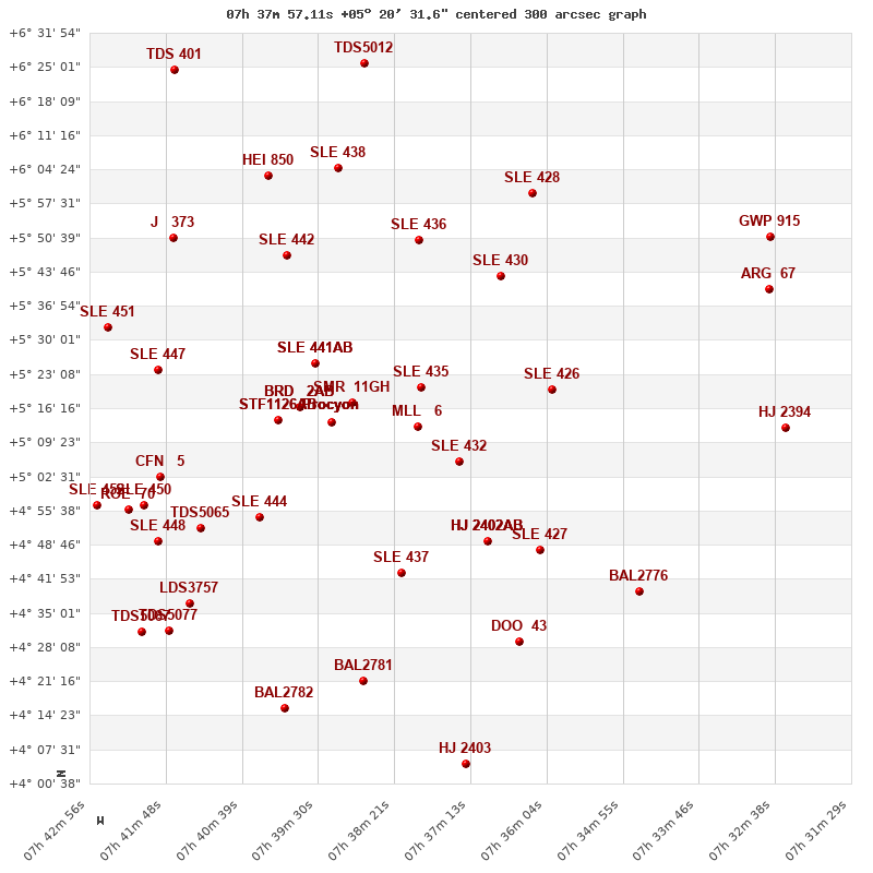
Click on the map to see the double of your interest.
Pass over with the mouse cursor to display the catalog designation.
|
| Show |
name |
coord_2000 |
discov# |
comp |
pa |
sep |
dist(') |
| Show |
|
07380+0521 |
SLE 435 |
|
287 |
5.9 |
|
| Show |
|
07380+0513 |
MLL 6 |
|
73 |
2.7 |
8 |
| Show |
|
07393+0514 |
SMR 11 |
GH |
277 |
33.6 |
16 |
| Show |
|
07374+0506 |
SLE 432 |
|
139 |
14.5 |
18 |
| Show |
Procyon |
07393+0514 |
SHB 1 |
AB |
286 |
3.8 |
22 |
| Show |
Procyon |
07393+0514 |
LAM 6 |
AC |
22 |
180.2 |
22 |
| Show |
Procyon |
07393+0514 |
DIC 1 |
AD |
326 |
116.7 |
22 |
| Show |
Procyon |
07393+0514 |
D 29 |
AE |
67 |
467.4 |
22 |
| Show |
Procyon |
07393+0514 |
SLE 439 |
AF |
333 |
172.3 |
22 |
| Show |
Procyon |
07393+0514 |
SMR 11 |
AG |
314 |
355.7 |
22 |
| Show |
|
07396+0525 |
SLE 441 |
AB |
151 |
11.3 |
25 |
| Show |
|
07396+0525 |
FYM 169 |
AC |
9 |
10.8 |
25 |
| Show |
|
07398+0516 |
BRD 2 |
AB |
187 |
0.9 |
28 |
| Show |
|
07398+0516 |
BRD 2 |
AB,C |
335 |
37.3 |
28 |
| Show |
|
07368+0543 |
SLE 430 |
|
91 |
15.3 |
29 |
| Show |
|
07360+0520 |
SLE 426 |
|
137 |
19.3 |
30 |
| Show |
|
07380+0550 |
SLE 436 |
|
259 |
17.8 |
30 |
| Show |
|
07401+0514 |
STF1126 |
AB |
176 |
0.9 |
34 |
| Show |
|
07401+0514 |
STF1126 |
AC |
250 |
43.1 |
34 |
| Show |
|
07369+0501 |
HJ 2402 |
AB |
288 |
27.9 |
35 |
| Show |
|
07369+0501 |
HJ 2402 |
AC |
329 |
38.1 |
35 |
| Show |
|
07369+0501 |
HJ 2402 |
AD |
74 |
64.7 |
35 |
| Show |
|
07383+0443 |
SLE 437 |
|
314 |
11.6 |
38 |
| Show |
|
07400+0547 |
SLE 442 |
|
204 |
13.4 |
41 |
| Show |
|
07362+0448 |
SLE 427 |
|
143 |
7.4 |
43 |
| Show |
|
07404+0454 |
SLE 444 |
|
181 |
15.8 |
45 |
| Show |
|
07363+0600 |
SLE 428 |
|
309 |
9.6 |
47 |
| Show |
|
07392+0605 |
SLE 438 |
|
192 |
8.1 |
48 |
| Show |
|
07404+0603 |
HEI 850 |
|
8 |
1.2 |
55 |
| Show |
|
07365+0429 |
DOO 43 |
|
200 |
15.0 |
56 |
| Show |
|
07413+0452 |
TDS5065 |
|
34 |
1.5 |
58 |
| Show |
|
07419+0524 |
SLE 447 |
|
325 |
20.6 |
60 |
| Show |
|
07389+0421 |
BAL2781 |
|
10 |
6.1 |
61 |
| Show |
|
07419+0502 |
CFN 5 |
|
136 |
1.0 |
62 |
| Show |
|
07417+0551 |
J 373 |
|
98 |
1.6 |
64 |
| Show |
|
07347+0439 |
BAL2776 |
|
269 |
5.6 |
64 |
| Show |
|
07388+0626 |
TDS5012 |
|
146 |
2.3 |
67 |
| Show |
|
07419+0449 |
SLE 448 |
|
218 |
7.4 |
67 |
| Show |
|
07421+0457 |
SLE 450 |
|
188 |
6.1 |
67 |
| Show |
|
07415+0437 |
LDS3757 |
|
348 |
90.5 |
68 |
| Show |
|
07423+0455 |
ROE 70 |
|
332 |
9.3 |
71 |
| Show |
|
07427+0533 |
SLE 451 |
|
157 |
15.6 |
72 |
| Show |
|
07400+0416 |
BAL2782 |
|
113 |
1.8 |
72 |
| Show |
|
07418+0431 |
TDS5077 |
|
63 |
0.6 |
76 |
| Show |
|
07373+0406 |
HJ 2403 |
|
283 |
7.7 |
77 |
| Show |
|
07428+0457 |
SLE 452 |
|
138 |
18.7 |
77 |
| Show |
|
07422+0431 |
TDS5087 |
|
179 |
2.2 |
80 |
| Show |
|
07327+0540 |
ARG 67 |
|
140 |
24.8 |
81 |
| Show |
|
07325+0512 |
HJ 2394 |
|
69 |
10.7 |
83 |
| Show |
|
07327+0551 |
GWP 915 |
|
146 |
26.1 |
85 |
| Show |
|
07417+0624 |
TDS 401 |
|
102 |
0.8 |
85 |
|
|
WDS 07380+0521 : COMPONENTS
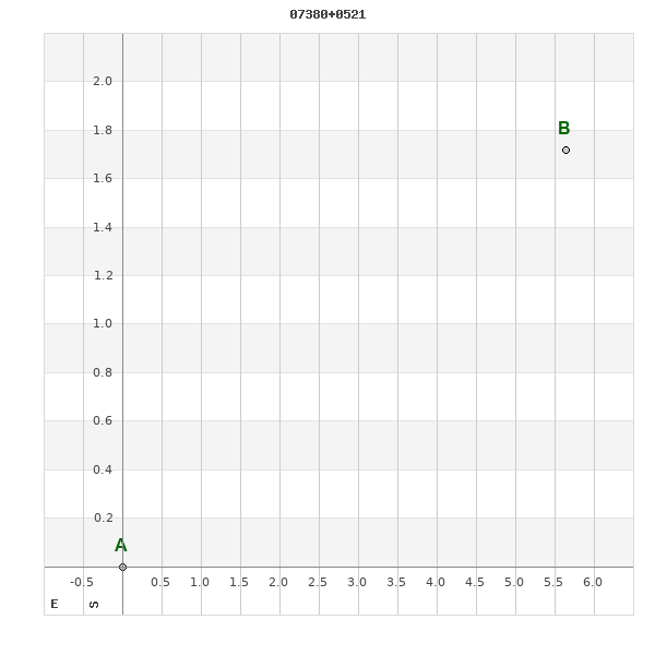
07380+0521 A
| Componente originario normalizzato |
AB |
|
Coord arcsec 2000 |
073757.11+052031.6 |
|
Mag |
11.9 |
|
PmRA |
11.00 |
|
| PmDE |
-2.0 |
|
07380+0521 B
| Componente originario normalizzato |
AB |
|
Coord arcsec 2000 |
073756.73+052033.3 |
|
Mag |
12.8 |
|
PmRA |
-42.00 |
|
| PmDE |
11.0 |
|
Calc delta mag |
0.9 |
|
Calc coord |
yes |
|