18083+1318 GWP 2762 AD
18h 08m 19.03s +13° 17' 34.4" P.A. 73.00 sep 159.4 mag 10.70,16.70
| Coord 2000 |
18083+1318 |
|
Discov num |
GWP2762 |
|
Comp |
AD |
|
Coord arcsec 2000 |
18 08 19.03 +13 17 34.4 |
|
| Date first |
1950 |
|
Date last |
2015 |
|
Obs |
5 |
|
| Pa first |
73 |
|
Pa last |
72.6 |
|
P.A. Now (θ) |
72.6° |
|
| Sep first |
161.4 |
|
Sep last |
159.38 |
|
Sep. Now (ρ) |
159.38" |
|
| Mag pri |
10.70 |
|
Mag sec |
16.70 |
|
delta mag (ΔM) |
6 |
|
Spectral class |
|
|
| Pri motion ra |
+000 |
|
Sec motion ra |
+000 |
|
| Pri motion dec |
-070 |
|
Sec motion dec |
+000 |
|
| Notes |
V
(Proper motion indicates physical) |
|
rPM=1
This double is physical.
18083+1318 SYSTEM COMPONENTS
| Show |
name |
SAO |
coord |
wds_name |
last |
obs |
pa |
sep |
mag1 |
mag2 |
d_mag |
orb |
current |
| Show |
|
|
18 08 19 +13 17 34 |
GWP 2760 AB |
2017 |
11 |
11 |
28.6 |
10.70 |
17.30 |
6.60 |
|
|
| Show |
|
|
18 08 19 +13 17 34 |
GWP 2761 AC |
2020 |
10 |
40 |
99.6 |
10.70 |
12.70 |
2.00 |
|
|
| Show |
|
|
18 08 19 +13 17 34 |
GWP 2762 AD |
2015 |
5 |
73 |
159.4 |
10.70 |
16.70 |
6.00 |
|
<=== |
Quadruple system
4 estimated visually detectable stars in this system
OTHER CATALOGS AND DESIGNATIONS
| Constellation |
Ophiuchus |
|
Tycho2 |
1021-01355-1 |
|
Gaia DR2 |
4497231603921545216 |
|
WDS 18083+1318 GWP 2762 AD : NOTES
No records found.
REFERENCES
| refcode |
metd |
author |
reference |
| GWP |
|
Garraf Wide Pairs: CPM wide pairs (>50mas/y) discovered in the Garraf Astronomical |
|
| GWP |
|
Observatory (OAG) CPMWP Survey |
|
| GWP |
|
Part I (2012): Measures of 1725 pairs. Equatorial zone |
|
| GWP |
|
(RA 00h00m to 11h59m, DEC +20 to -20 deg) |
|
| GWP |
|
Garraf Wide Pairs: CPM wide pairs (>50mas/y) discovered in the Garraf Astronomical |
|
| GWP |
|
Observatory (OAG) CPMWP Survey |
|
| GWP |
|
Part II (2016): Measures of 1657 pairs. Equatorial zone |
|
| GWP |
|
(RA 12h00m to 23h59m, DEC +20 to -20 deg) |
|
WDS HISTORIC DATA
| coord_2000 |
discov_num |
comp |
epoch |
obs |
pa |
sep |
mag_pri |
mag_sec |
spectr |
notes |
coord_arcsec_2000 |
| 18083+1318 |
GWP2762 |
AD |
1999 |
3 |
73 |
159.1 |
10.70 |
16.70 |
|
V |
180819.03+131734.4 |
| 18083+1318 |
GWP2762 |
AD |
2001 |
4 |
73 |
159.0 |
10.70 |
16.70 |
|
V |
180819.03+131734.4 |
| 18083+1318 |
GWP2762 |
AD |
2015 |
5 |
73 |
159.4 |
10.70 |
16.70 |
|
V |
180819.03+131734.4 |
If you need more information about this double, apply for a
data request form to the WDS.
WDS 18083+1318 GWP 2762 AD : VISUAL OBSERVATIONS REPORTS
No records found.
WDS 18083+1318 GWP 2762 AD : MEASURES
No records found.
WDS 18083+1318 : VIRTUAL EYEPIECE
Click on the map to see the double of your interest.
Pass over with the mouse cursor to display the catalog designation.
|
|
WDS 18083+1318 : ALADIN DSS IMAGE @ 18h 08m 19.03s +13° 17' 34.4"
WDS 18083+1318 GWP 2762 AD : NEIGHBORHOODS
|
|
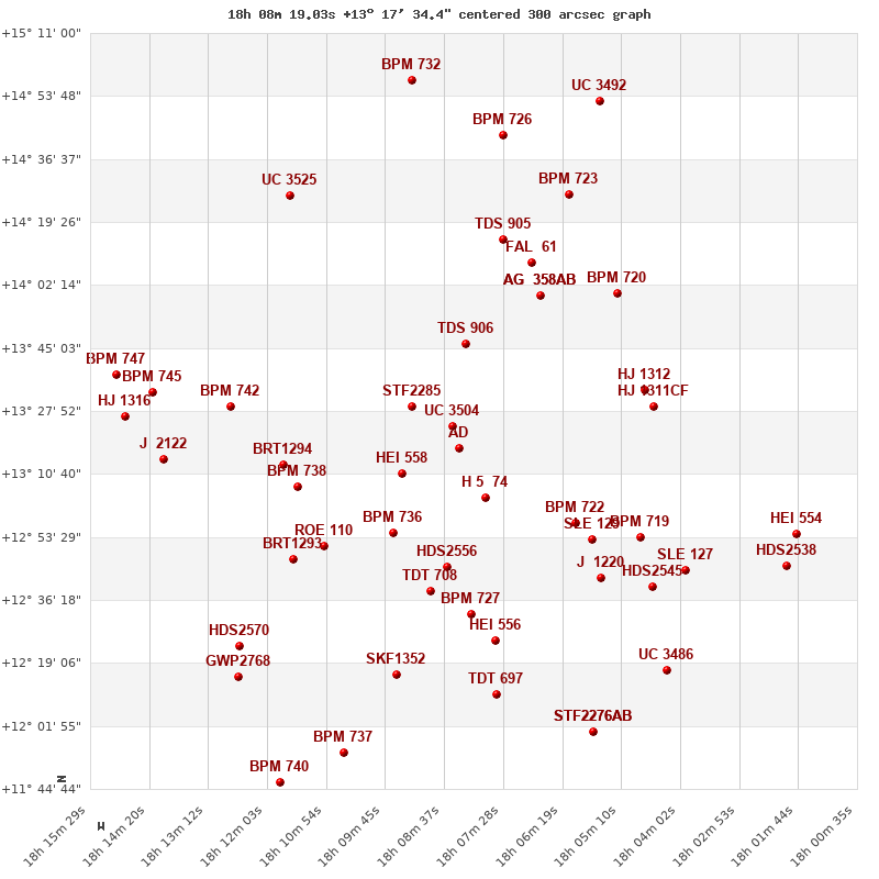
Click on the map to see the double of your interest.
Pass over with the mouse cursor to display the catalog designation.
|
| Show |
name |
coord_2000 |
discov# |
comp |
pa |
sep |
dist(') |
| Show |
|
18083+1318 |
GWP2760 |
AB |
11 |
28.6 |
|
| Show |
|
18083+1318 |
GWP2761 |
AC |
40 |
99.6 |
|
| Show |
|
18083+1318 |
GWP2762 |
AD |
73 |
159.4 |
|
| Show |
|
18085+1324 |
UC 3504 |
|
333 |
50.0 |
7 |
| Show |
|
18078+1304 |
H 5 74 |
|
140 |
42.7 |
16 |
| Show |
|
18094+1311 |
HEI 558 |
|
142 |
2.7 |
18 |
| Show |
|
18093+1329 |
STF2285 |
|
333 |
3.6 |
18 |
| Show |
|
18082+1346 |
TDS 906 |
|
29 |
1.2 |
29 |
| Show |
|
18096+1255 |
BPM 736 |
|
193 |
85.2 |
30 |
| Show |
|
18086+1245 |
HDS2556 |
|
124 |
0.5 |
33 |
| Show |
|
18061+1257 |
BPM 722 |
|
340 |
105.0 |
39 |
| Show |
|
18089+1239 |
TDT 708 |
|
83 |
1.0 |
40 |
| Show |
|
18057+1253 |
SLE 129 |
|
272 |
11.0 |
46 |
| Show |
|
18081+1232 |
BPM 727 |
|
203 |
43.6 |
46 |
| Show |
|
18109+1251 |
ROE 110 |
|
135 |
3.8 |
47 |
| Show |
|
18115+1307 |
BPM 738 |
|
48 |
107.9 |
48 |
| Show |
|
18067+1359 |
AG 358 |
AB |
330 |
3.7 |
48 |
| Show |
|
18067+1359 |
FOX 219 |
AD |
318 |
86.4 |
48 |
| Show |
|
18067+1359 |
COU 8 |
BC |
120 |
0.9 |
48 |
| Show |
|
18117+1313 |
BRT1294 |
|
281 |
3.9 |
51 |
| Show |
|
18056+1242 |
J 1220 |
|
128 |
1.5 |
54 |
| Show |
|
18076+1225 |
HEI 556 |
|
114 |
1.8 |
54 |
| Show |
|
18069+1408 |
FAL 61 |
|
129 |
6.5 |
55 |
| Show |
|
18048+1333 |
HJ 1312 |
|
60 |
25.2 |
55 |
| Show |
|
18116+1247 |
BRT1293 |
|
74 |
5.4 |
57 |
| Show |
|
18046+1329 |
HJ 1311 |
CF |
55 |
7.4 |
57 |
| Show |
|
18048+1253 |
BPM 719 |
|
277 |
18.7 |
57 |
| Show |
|
18075+1415 |
TDS 905 |
|
115 |
1.3 |
59 |
| Show |
|
18053+1400 |
BPM 720 |
|
327 |
54.4 |
62 |
| Show |
|
18095+1216 |
SKF1352 |
|
42 |
14.3 |
65 |
| Show |
|
18128+1329 |
BPM 742 |
|
173 |
102.2 |
66 |
| Show |
|
18046+1240 |
HDS2545 |
|
121 |
0.1 |
67 |
| Show |
|
18076+1210 |
TDT 697 |
|
167 |
2.2 |
68 |
| Show |
|
18039+1244 |
SLE 127 |
|
304 |
8.6 |
73 |
| Show |
|
18062+1427 |
BPM 723 |
|
255 |
80.4 |
76 |
| Show |
|
18126+1224 |
HDS2570 |
|
352 |
0.1 |
83 |
| Show |
|
18116+1426 |
UC 3525 |
|
289 |
65.8 |
84 |
| Show |
|
18141+1314 |
J 2122 |
|
329 |
5.6 |
85 |
| Show |
|
18043+1217 |
UC 3486 |
|
177 |
50.6 |
85 |
| Show |
|
18057+1200 |
STF2276 |
AB |
257 |
7.1 |
87 |
| Show |
|
18057+1200 |
STF2276 |
AC |
306 |
63.8 |
87 |
| Show |
|
18057+1200 |
STF2276 |
BC |
311 |
58.7 |
87 |
| Show |
|
18075+1443 |
BPM 726 |
|
236 |
23.4 |
87 |
| Show |
|
18143+1333 |
BPM 745 |
|
73 |
29.0 |
89 |
| Show |
|
18126+1215 |
GWP2768 |
|
268 |
11.3 |
89 |
| Show |
|
18106+1155 |
BPM 737 |
|
261 |
29.0 |
90 |
| Show |
|
18148+1327 |
HJ 1316 |
|
250 |
14.0 |
96 |
| Show |
|
18020+1245 |
HDS2538 |
|
210 |
0.4 |
99 |
| Show |
|
18018+1254 |
HEI 554 |
|
13 |
2.6 |
99 |
| Show |
|
18150+1338 |
BPM 747 |
|
55 |
99.8 |
100 |
| Show |
|
18092+1458 |
BPM 732 |
|
187 |
35.7 |
102 |
|
|
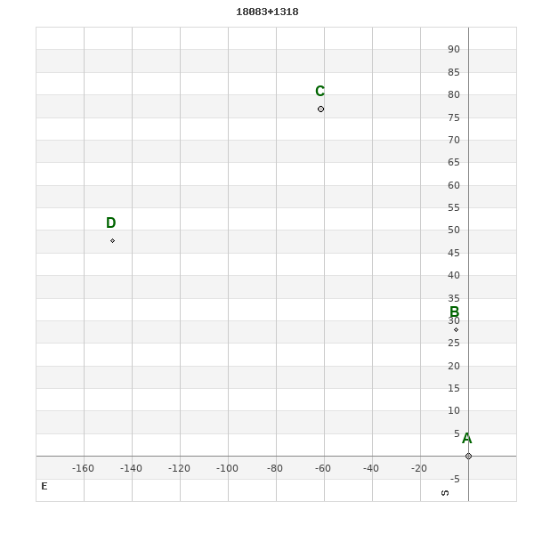
WDS 18083+1318 : COMPONENTS
| |
A |
B |
C |
| B |
pa=10.6°
sep=28.58"
| |
| C |
pa=38.7°
sep=98.50"
| pa=49.2°
sep=74.52"
| |
| D |
pa=72.2°
sep=155.49"
| pa=82.2°
sep=144.08"
| pa=108.7°
sep=91.16"
|
18083+1318 A
| Coord arcsec 2000 |
180819.03+131734.4 |
|
Mag |
10.7 |
|
PmRA |
0.00 |
|
PmDE |
-70.0 |
|
| Tycho2 |
1021-01355-1 |
|
| Tycho2 |
1021-01355-1 |
|
Pflag |
|
|
RAmdeg |
272.07926788 |
|
DEmdeg |
13.29288004 |
|
| PmRA |
1.9 |
|
PmDE |
-69.0 |
|
E RAmdeg |
29 |
|
E DEmdeg |
28 |
|
| E pmRA |
1.3 |
|
E pmDE |
1.3 |
|
EpRAm |
1984.69 |
|
EpDEm |
1982.48 |
|
| Num |
5 |
|
Q RAmdeg |
0.8 |
|
Q DEmdeg |
1.7 |
|
Q pmRA |
0.8 |
|
| Q pmDE |
1.6 |
|
BTmag |
11.492 |
|
E BTmag |
0.065 |
|
VTmag |
10.787 |
|
| E VTmag |
0.056 |
|
Prox |
999 |
|
TYC |
T |
|
HIP |
|
|
| CCDM |
|
|
RAdeg |
272.07926500 |
|
DEdeg |
13.29302667 |
|
EpRA 1990 |
1.74 |
|
| EpDE 1990 |
1.56 |
|
E RAdeg |
33.9 |
|
E DEdeg |
39.3 |
|
Posflg |
|
|
| Corr |
-0.1 |
|
18083+1318 B
| Coord arcsec 2000 |
180819.39+131802.5 |
|
Mag |
17.3 |
|
PmRA |
-4.00 |
|
PmDE |
-70.0 |
|
| Calc delta mag |
6.6 |
|
Calc coord |
yes |
|
18083+1318 C
| Coord arcsec 2000 |
180823.25+131851.2 |
|
Mag |
12.7 |
|
PmRA |
0.00 |
|
PmDE |
0.0 |
|
| Calc delta mag |
2 |
|
Calc coord |
yes |
|
18083+1318 D
| Coord arcsec 2000 |
180829.17+131822.1 |
|
Mag |
16.7 |
|
PmRA |
0.00 |
|
PmDE |
0.0 |
|
| Calc delta mag |
6 |
|
Calc coord |
yes |
|