10143+0214 GWP 1321 AB
10h 14m 17.64s +02° 13' 58.5" P.A. 152.00 sep 19.0 mag 12.50,14.90 Sp +M0.4
| Coord 2000 |
10143+0214 |
|
Discov num |
GWP1321 |
|
Comp |
AB |
|
Coord arcsec 2000 |
10 14 17.64 +02 13 58.5 |
|
| Date first |
1991 |
|
Date last |
2016 |
|
Obs |
8 |
|
| Pa first |
151 |
|
Pa last |
152.1 |
|
P.A. Now (θ) |
152.1° |
|
| Sep first |
19.0 |
|
Sep last |
19.031 |
|
Sep. Now (ρ) |
19.031" |
|
| Mag pri |
12.50 |
|
Mag sec |
14.90 |
|
delta mag (ΔM) |
2.4 |
|
Spectral class |
+M0.4 |
|
| Pri motion ra |
-060 |
|
Sec motion ra |
-041 |
|
| Pri motion dec |
-019 |
|
Sec motion dec |
-019 |
|
| Notes |
V
(Proper motion indicates physical) |
|
rPM=0.302
This double is physical.
10143+0214 SYSTEM COMPONENTS
| Show |
name |
SAO |
coord |
wds_name |
last |
obs |
pa |
sep |
mag1 |
mag2 |
d_mag |
orb |
current |
| Show |
|
|
10 14 18 +02 13 58 |
GWP 1321 AB |
2016 |
8 |
152 |
19.0 |
12.50 |
14.90 |
2.40 |
|
<=== |
| Show |
|
|
10 14 18 +02 13 58 |
GWP 1321 AC |
2015 |
5 |
77 |
85.3 |
12.50 |
20.00 |
7.50 |
|
|
| Show |
|
|
10 14 18 +02 13 42 |
SLW 450 BC |
2015 |
6 |
64 |
82.6 |
14.90 |
20.00 |
5.10 |
|
|
Triple system
3 estimated visually detectable stars in this system
OTHER CATALOGS AND DESIGNATIONS
| Constellation |
Sextans |
|
Gaia DR2 |
3835594365867604352 |
|
WDS 10143+0214 GWP 1321 AB : NOTES
No records found.
REFERENCES
| refcode |
metd |
author |
reference |
| GWP |
|
Garraf Wide Pairs: CPM wide pairs (>50mas/y) discovered in the Garraf Astronomical |
|
| GWP |
|
Observatory (OAG) CPMWP Survey |
|
| GWP |
|
Part I (2012): Measures of 1725 pairs. Equatorial zone |
|
| GWP |
|
(RA 00h00m to 11h59m, DEC +20 to -20 deg) |
|
| GWP |
|
Garraf Wide Pairs: CPM wide pairs (>50mas/y) discovered in the Garraf Astronomical |
|
| GWP |
|
Observatory (OAG) CPMWP Survey |
|
| GWP |
|
Part II (2016): Measures of 1657 pairs. Equatorial zone |
|
| GWP |
|
(RA 12h00m to 23h59m, DEC +20 to -20 deg) |
|
| SLW |
|
Sloan Digital Sky Survey SLoWPoKES Catalog |
................... |
| SLW |
|
(catalog of wide, low-mass CPM pairs - see Dhital et al. 2010) |
2010AJ....139.2566D |
WDS HISTORIC DATA
| coord_2000 |
discov_num |
comp |
epoch |
obs |
pa |
sep |
mag_pri |
mag_sec |
spectr |
notes |
coord_arcsec_2000 |
| 10143+0214 |
GWP1321 |
AB |
2000 |
2 |
152 |
19.0 |
12.50 |
14.90 |
M0.4 |
V |
101417.64+021358.5 |
| 10143+0214 |
GWP1321 |
AB |
2016 |
4 |
152 |
19.0 |
12.50 |
14.90 |
+M0.4 |
V |
101417.64+021358.5 |
If you need more information about this double, apply for a
data request form to the WDS.
WDS 10143+0214 GWP 1321 AB : VISUAL OBSERVATIONS REPORTS
No records found.
WDS 10143+0214 GWP 1321 AB : MEASURES
No records found.
WDS 10143+0214 : VIRTUAL EYEPIECE
Click on the map to see the double of your interest.
Pass over with the mouse cursor to display the catalog designation.
|
|
WDS 10143+0214 : ALADIN DSS IMAGE @ 10h 14m 17.64s +02° 13' 58.5"
WDS 10143+0214 GWP 1321 AB : NEIGHBORHOODS
|
|

Click on the map to see the double of your interest.
Pass over with the mouse cursor to display the catalog designation.
|
| Show |
name |
coord_2000 |
discov# |
comp |
pa |
sep |
dist(') |
| Show |
|
10143+0214 |
GWP1321 |
AB |
152 |
19.0 |
|
| Show |
|
10143+0214 |
GWP1321 |
AC |
77 |
85.3 |
|
| Show |
|
10143+0214 |
SLW 450 |
BC |
64 |
82.6 |
1 |
| Show |
|
10145+0213 |
RAO 572 |
|
157 |
0.7 |
4 |
| Show |
|
10145+0153 |
CBL 306 |
|
226 |
21.3 |
22 |
| Show |
|
10129+0221 |
BAL1870 |
|
9 |
18.9 |
22 |
| Show |
|
10127+0212 |
BAL1868 |
|
331 |
5.9 |
25 |
| Show |
|
10129+0158 |
BAL1869 |
|
257 |
7.9 |
27 |
| Show |
|
10141+0145 |
BAL1871 |
|
166 |
14.4 |
30 |
| Show |
|
10139+0246 |
HEI 758 |
|
48 |
0.7 |
33 |
| Show |
|
10169+0225 |
YSC 38 |
|
270 |
0.9 |
41 |
| Show |
|
10125+0245 |
BAL2370 |
CD |
352 |
20.1 |
43 |
| Show |
|
10125+0245 |
DAM 68 |
AB |
101 |
14.9 |
43 |
| Show |
|
10125+0245 |
DAM 68 |
AC |
59 |
20.8 |
43 |
| Show |
|
10125+0245 |
DAM 68 |
AD |
27 |
33.9 |
43 |
| Show |
|
10152+0134 |
BAL1872 |
|
236 |
6.1 |
43 |
| Show |
|
10125+0245 |
DAM 68 |
DE |
91 |
5.5 |
43 |
| Show |
|
10175+0225 |
SLW 457 |
|
93 |
112.5 |
50 |
| Show |
|
10140+0306 |
CBL 304 |
|
278 |
26.6 |
53 |
| Show |
|
10179+0213 |
CVR 557 |
|
9 |
17.0 |
55 |
| Show |
|
10106+0254 |
TDS7081 |
|
4 |
1.3 |
69 |
| Show |
|
10187+0243 |
BAL2371 |
|
219 |
3.5 |
73 |
| Show |
|
10115+0313 |
DAM2111 |
|
33 |
9.9 |
73 |
| Show |
|
10118+0317 |
HEI 756 |
AB |
102 |
0.9 |
73 |
| Show |
|
10118+0317 |
DAM2120 |
AB,C |
199 |
8.4 |
73 |
| Show |
|
10109+0118 |
GRV 813 |
|
321 |
42.9 |
76 |
| Show |
|
10149-0059 |
GWP1325 |
|
355 |
14.9 |
76 |
| Show |
|
10138+0337 |
GWP1312 |
|
81 |
16.8 |
84 |
| Show |
|
10158+0336 |
BAL2840 |
|
189 |
11.6 |
86 |
| Show |
|
10204+0156 |
BAL1874 |
|
350 |
11.8 |
88 |
| Show |
|
10159+0339 |
GWP1331 |
|
138 |
118.5 |
89 |
| Show |
|
10097+0310 |
STF1412 |
AB |
293 |
30.7 |
89 |
| Show |
|
10097+0310 |
STF1412 |
AC |
52 |
90.0 |
89 |
| Show |
|
10103+0107 |
CBL 303 |
|
114 |
8.6 |
90 |
| Show |
|
10161-0048 |
DAM2211 |
|
222 |
7.2 |
91 |
| Show |
|
10199+0249 |
DAM2286 |
|
145 |
6.9 |
92 |
| Show |
|
10094+0118 |
BAL1437 |
AB |
261 |
1.8 |
93 |
| Show |
|
10094+0118 |
BAL1437 |
AC |
128 |
2.9 |
93 |
| Show |
|
10202+0245 |
HEI 759 |
|
64 |
0.3 |
94 |
| Show |
|
10137+0031 |
BAL1438 |
|
290 |
2.9 |
104 |
| Show |
|
10190-0056 |
DAM2305 |
|
94 |
2.7 |
105 |
| Show |
|
10087+0110 |
KPP3806 |
|
180 |
17.0 |
106 |
| Show |
|
10204+0310 |
HDS1485 |
|
331 |
0.3 |
108 |
| Show |
|
10212+0131 |
BAL1875 |
|
344 |
13.3 |
113 |
| Show |
|
10192-0048 |
DAM2308 |
|
178 |
4.0 |
114 |
| Show |
|
10143-0021 |
DAM2167 |
|
184 |
44.2 |
114 |
| Show |
|
10187+0042 |
SLW 461 |
|
76 |
57.2 |
114 |
| Show |
|
10148-0017 |
A 2566 |
|
97 |
1.7 |
118 |
| Show |
|
10069+0258 |
GAT 4 |
|
212 |
2.5 |
119 |
| Show |
|
10072+0117 |
BAL1436 |
|
228 |
10.6 |
121 |
| Show |
|
10115-0018 |
RST5345 |
|
14 |
2.5 |
124 |
|
|
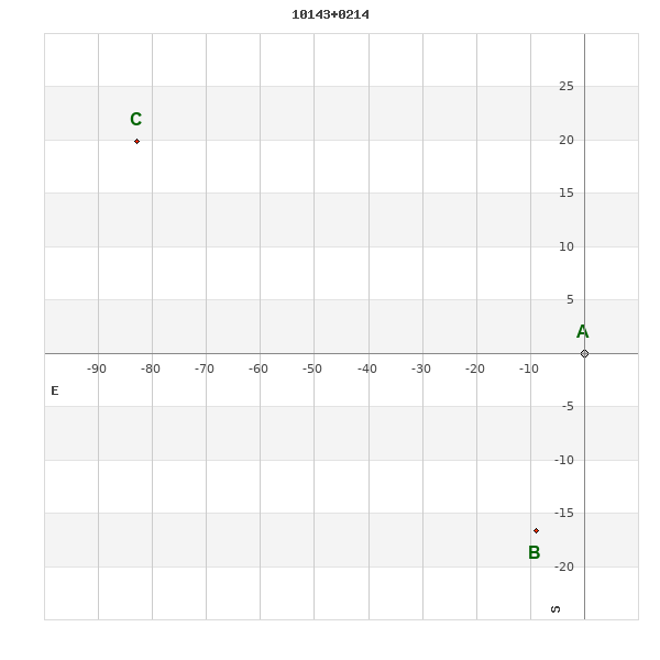
WDS 10143+0214 : COMPONENTS
| |
A |
B |
| B |
pa=152.0°
sep=18.81"
| |
| C |
pa=76.5°
sep=85.21"
| pa=63.7°
sep=82.53"
|
10143+0214 A
| Coord arcsec 2000 |
101417.64+021358.5 |
|
Mag |
12.5 |
|
PmRA |
-60.00 |
|
PmDE |
-19.0 |
|
10143+0214 B
| Coord arcsec 2000 |
101418.23+021341.9 |
|
Coord calc |
101418.23+021341.9 |
|
Mag |
14.9 |
|
Spectral class |
M0.4 (red) |
|
| PmRA |
-56.00 |
|
PmDE |
-17.0 |
|
Calc delta mag |
2.4 |
|
10143+0214 C
| Coord arcsec 2000 |
101423.17+021418.4 |
|
Mag |
20 |
|
Spectral class |
M3.9 (red) |
|
PmRA |
-54.00 |
|
| PmDE |
-14.0 |
|
Calc delta mag |
7.5 |
|
Calc coord |
yes |
|