03070+1816 LDS 3453 AC
03h 06m 58.97s +18° 16' 28.5" P.A. 129.00 sep 56.6 mag 12.31,17.30
| Coord 2000 |
03070+1816 |
|
Discov num |
LDS3453 |
|
Comp |
AC |
|
Coord arcsec 2000 |
03 06 58.97 +18 16 28.5 |
|
| Date first |
1960 |
|
Date last |
2015 |
|
Obs |
3 |
|
| Pa first |
130 |
|
Pa last |
128.8 |
|
P.A. Now (θ) |
128.8° |
|
| Sep first |
59.0 |
|
Sep last |
56.61 |
|
Sep. Now (ρ) |
56.61" |
|
| Mag pri |
12.31 |
|
Mag sec |
17.30 |
|
delta mag (ΔM) |
4.99 |
|
Spectral class |
|
|
| Pri motion ra |
+011 |
|
Sec motion ra |
+010 |
|
| Pri motion dec |
-119 |
|
Sec motion dec |
-082 |
|
| Notes |
V
(Proper motion indicates physical) |
|
rPM=0.31
This double is physical.
03070+1816 SYSTEM COMPONENTS
| Show |
name |
SAO |
coord |
wds_name |
last |
obs |
pa |
sep |
mag1 |
mag2 |
d_mag |
orb |
current |
| Show |
|
|
03 06 59 +18 16 28 |
LDS 3453 AB |
2015 |
3 |
259 |
173.0 |
12.31 |
13.36 |
1.05 |
|
|
| Show |
|
|
03 06 59 +18 16 28 |
LDS 3453 AC |
2015 |
3 |
129 |
56.6 |
12.31 |
17.30 |
4.99 |
|
<=== |
| Show |
|
|
03 06 47 +18 15 56 |
GWP 422 BC |
2015 |
3 |
91 |
214.2 |
13.36 |
17.30 |
3.94 |
|
|
Triple system
3 estimated visually detectable stars in this system
OTHER CATALOGS AND DESIGNATIONS
| Constellation |
Aries |
|
Tycho2 |
1228-01345-1 |
|
Gaia DR2 |
58925512487888896 |
|
WDS 03070+1816 LDS 3453 AC : NOTES
No records found.
REFERENCES
| refcode |
metd |
author |
reference |
| GWP |
|
Garraf Wide Pairs: CPM wide pairs (>50mas/y) discovered in the Garraf Astronomical |
|
| GWP |
|
Observatory (OAG) CPMWP Survey |
|
| GWP |
|
Part I (2012): Measures of 1725 pairs. Equatorial zone |
|
| GWP |
|
(RA 00h00m to 11h59m, DEC +20 to -20 deg) |
|
| GWP |
|
Garraf Wide Pairs: CPM wide pairs (>50mas/y) discovered in the Garraf Astronomical |
|
| GWP |
|
Observatory (OAG) CPMWP Survey |
|
| GWP |
|
Part II (2016): Measures of 1657 pairs. Equatorial zone |
|
| GWP |
|
(RA 12h00m to 23h59m, DEC +20 to -20 deg) |
|
| LDS |
|
Luyten p.m. catalog (from additional DD list) |
................... |
WDS HISTORIC DATA
| coord_2000 |
discov_num |
comp |
epoch |
obs |
pa |
sep |
mag_pri |
mag_sec |
spectr |
notes |
coord_arcsec_2000 |
| 03070+1816 |
LDS3453 |
AC |
1998 |
2 |
130 |
57.2 |
11.85 |
17.30 |
|
vD |
030658.97+181628.5 |
| 03070+1816 |
LDS3453 |
AC |
2015 |
3 |
129 |
56.6 |
12.31 |
17.30 |
|
V |
030658.97+181628.5 |
If you need more information about this double, apply for a
data request form to the WDS.
WDS 03070+1816 LDS 3453 AC : VISUAL OBSERVATIONS REPORTS
No records found.
WDS 03070+1816 LDS 3453 AC : MEASURES
No records found.
WDS 03070+1816 : VIRTUAL EYEPIECE
Click on the map to see the double of your interest.
Pass over with the mouse cursor to display the catalog designation.
|
|
WDS 03070+1816 : ALADIN DSS IMAGE @ 03h 06m 58.97s +18° 16' 28.5"
WDS 03070+1816 LDS 3453 AC : NEIGHBORHOODS
|
|
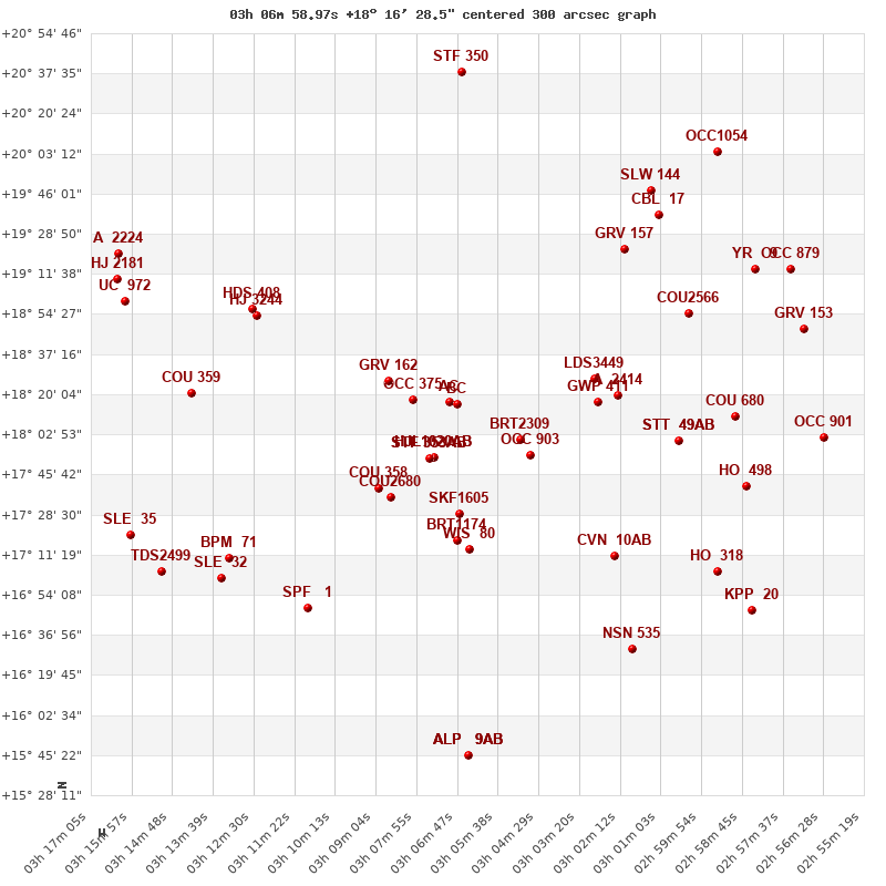
Click on the map to see the double of your interest.
Pass over with the mouse cursor to display the catalog designation.
|
| Show |
name |
coord_2000 |
discov# |
comp |
pa |
sep |
dist(') |
| Show |
|
03070+1816 |
LDS3453 |
AB |
259 |
173.0 |
|
| Show |
|
03070+1816 |
LDS3453 |
AC |
129 |
56.6 |
|
| Show |
|
03070+1816 |
GWP 422 |
BC |
91 |
214.2 |
3 |
| Show |
|
03080+1818 |
OCC 375 |
|
-1 |
0.3 |
15 |
| Show |
|
03074+1753 |
HJL1020 |
AB |
359 |
105.8 |
25 |
| Show |
|
03074+1753 |
OCC 395 |
Aa,Ab |
-1 |
0.0 |
25 |
| Show |
|
03075+1753 |
STF 353 |
AB |
53 |
12.4 |
26 |
| Show |
|
03075+1753 |
FOX 128 |
AC |
17 |
30.0 |
26 |
| Show |
|
03087+1825 |
GRV 162 |
|
232 |
10.2 |
27 |
| Show |
|
03050+1800 |
BRT2309 |
|
106 |
1.5 |
33 |
| Show |
|
03047+1754 |
OCC 903 |
|
-1 |
0.1 |
40 |
| Show |
|
03090+1740 |
COU 358 |
|
112 |
2.1 |
47 |
| Show |
|
03087+1736 |
COU2680 |
|
245 |
1.5 |
47 |
| Show |
|
03067+1729 |
SKF1605 |
|
240 |
56.4 |
48 |
| Show |
|
03029+1827 |
LDS3449 |
|
123 |
55.0 |
59 |
| Show |
|
03068+1717 |
BRT1174 |
|
152 |
4.2 |
60 |
| Show |
|
03028+1817 |
GWP 411 |
|
188 |
7.5 |
60 |
| Show |
|
03064+1713 |
WIS 80 |
|
217 |
999.9 |
64 |
| Show |
|
03023+1820 |
A 2414 |
|
68 |
0.5 |
68 |
| Show |
|
03124+1855 |
HJ 3244 |
|
97 |
8.6 |
86 |
| Show |
|
03125+1857 |
HDS 408 |
|
160 |
0.1 |
89 |
| Show |
|
03024+1711 |
CVN 10 |
AB |
132 |
0.8 |
94 |
| Show |
|
03024+1711 |
BNK 2 |
Ba,Bb |
57 |
0.1 |
94 |
| Show |
|
03005+1800 |
STT 49 |
AB |
48 |
2.3 |
94 |
| Show |
|
03005+1800 |
STT 49 |
AC |
208 |
147.1 |
94 |
| Show |
|
03020+1922 |
GRV 157 |
|
179 |
66.8 |
97 |
| Show |
|
03002+1853 |
COU2566 |
|
59 |
0.8 |
103 |
| Show |
|
03143+1821 |
COU 359 |
|
177 |
0.2 |
104 |
| Show |
|
03110+1648 |
SPF 1 |
|
222 |
0.2 |
106 |
| Show |
|
03132+1710 |
BPM 71 |
|
169 |
107.1 |
112 |
| Show |
|
02590+1811 |
COU 680 |
|
102 |
0.4 |
115 |
| Show |
|
03011+1937 |
CBL 17 |
|
194 |
30.9 |
116 |
| Show |
|
03134+1701 |
SLE 32 |
|
257 |
15.1 |
119 |
| Show |
|
03013+1947 |
SLW 144 |
|
99 |
12.3 |
122 |
| Show |
|
02586+1741 |
HO 498 |
|
62 |
0.4 |
125 |
| Show |
|
03018+1631 |
NSN 535 |
|
309 |
16.2 |
129 |
| Show |
|
02595+1704 |
HO 318 |
|
26 |
3.2 |
130 |
| Show |
|
02584+1914 |
YR 9 |
|
239 |
0.6 |
135 |
| Show |
|
03151+1704 |
TDS2499 |
|
196 |
0.4 |
137 |
| Show |
|
03161+1900 |
UC 972 |
|
62 |
23.9 |
138 |
| Show |
|
03160+1720 |
SLE 35 |
|
170 |
13.7 |
141 |
| Show |
|
03066+2038 |
STF 350 |
|
119 |
16.4 |
142 |
| Show |
|
03164+1910 |
HJ 2181 |
|
277 |
26.3 |
144 |
| Show |
|
02570+1848 |
GRV 153 |
|
277 |
7.6 |
146 |
| Show |
|
03163+1920 |
A 2224 |
|
331 |
0.8 |
148 |
| Show |
|
02574+1913 |
OCC 879 |
|
-1 |
0.1 |
148 |
| Show |
|
02585+1648 |
KPP 20 |
|
196 |
7.3 |
151 |
| Show |
|
02564+1801 |
OCC 901 |
|
-1 |
-1.0 |
152 |
| Show |
|
03064+1545 |
ALP 9 |
AB |
88 |
17.6 |
152 |
| Show |
|
03064+1545 |
ALP 9 |
AC |
62 |
18.4 |
152 |
| Show |
|
03064+1545 |
ALP 9 |
AD |
77 |
28.9 |
152 |
|
|
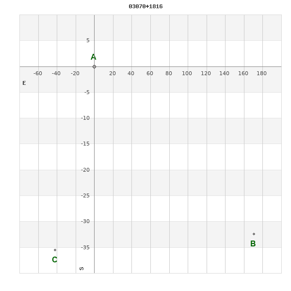
WDS 03070+1816 : COMPONENTS
| |
A |
B |
| B |
pa=259.2°
sep=173.41"
| |
| C |
pa=130.3°
sep=54.89"
| pa=90.8°
sep=212.28"
|
03070+1816 A
| Coord arcsec 2000 |
030658.97+181628.5 |
|
Mag |
12.31 |
|
PmRA |
16.00 |
|
PmDE |
-150.0 |
|
| Tycho2 |
1228-01345-1 |
|
| Tycho2 |
1228-01345-1 |
|
Pflag |
|
|
RAmdeg |
46.74572079 |
|
DEmdeg |
18.27459095 |
|
| PmRA |
16.2 |
|
PmDE |
-150.2 |
|
E RAmdeg |
95 |
|
E DEmdeg |
114 |
|
| E pmRA |
2.6 |
|
E pmDE |
2.8 |
|
EpRAm |
1975.36 |
|
EpDEm |
1967.99 |
|
| Num |
2 |
|
Q RAmdeg |
|
|
Q DEmdeg |
|
|
Q pmRA |
|
|
| Q pmDE |
|
|
BTmag |
13.427 |
|
E BTmag |
0.442 |
|
VTmag |
11.846 |
|
| E VTmag |
0.195 |
|
Prox |
999 |
|
TYC |
|
|
HIP |
|
|
| CCDM |
|
|
RAdeg |
46.74568222 |
|
DEdeg |
18.27494139 |
|
EpRA 1990 |
1.82 |
|
| EpDE 1990 |
1.60 |
|
E RAdeg |
104.3 |
|
E DEdeg |
132.0 |
|
Posflg |
|
|
| Corr |
-0.1 |
|
03070+1816 B
| Coord arcsec 2000 |
030647.01+181556.1 |
|
Coord calc |
030647.01+181556.1 |
|
Mag |
13.36 |
|
PmRA |
2.00 |
|
| PmDE |
-90.0 |
|
Calc delta mag |
1.05 |
|
03070+1816 C
| Coord arcsec 2000 |
030701.91+181553.0 |
|
Mag |
17.3 |
|
PmRA |
10.00 |
|
PmDE |
-82.0 |
|
| Calc delta mag |
4.99 |
|
Calc coord |
yes |
|